-
Paper Information
- Next Paper
- Paper Submission
-
Journal Information
- About This Journal
- Editorial Board
- Current Issue
- Archive
- Author Guidelines
- Contact Us
World Environment
p-ISSN: 2163-1573 e-ISSN: 2163-1581
2013; 3(5): 165-169
doi:10.5923/j.env.20130305.04
An Adaptive Monitoring System for Identify the Spots of Pollutants on the Water Surface
 Abstract
 Reference
 Full-Text PDF
 Full-text HTML
F. A. Mkrtchyan, V. F. Krapivin
Institute of Radioengineering & Electronics RAS, 1 Vvedensky Sq., Fryazino, Moscow reg., 141190, Russia
Correspondence to: F. A. Mkrtchyan, Institute of Radioengineering & Electronics RAS, 1 Vvedensky Sq., Fryazino, Moscow reg., 141190, Russia.
| Email: |  |
Copyright © 2012 Scientific & Academic Publishing. All Rights Reserved.
The problem of detection and identification of the pollution spots on the water surface, especially of oil spills, is being solved by many scientists. The recently developed technology of an adaptive identification of the environmental elements from measurements in the visible spectral region permits to synthesize an expert system for an adaptive identification of the environmental parameters (ESAIEP). The system’s structure includes a compact multi-channel spectropolarimeter (MSP), information interface with computer (IIC), computer software (STW), and extending database (EDB). The STW realizes a number of algorithms to process the data fluxes from MSP and provides service functions of visualization and control of the regime of measurements. The EDB consists of the sets of standard spectral images of the spots of pollutants represented by points in the multi-dimensional vector space of indicators, pre-calculated on the basis of learning samples. The principle of the ESAIEP functioning is based on fixation of changes of the light flux at the MSP output and their transformation into a digital code. Further processing of these data with respect to their efficiency is determined by the STW composition containing various algorithms of recognition of 2D objects. The adaptability of the recognition procedure is determined by the level of accumulated knowledge about special features of intensity fluctuations and polarizing properties of the light reflected from the water surface. The STW includes the means that make it possible, in case of uncertain identification of the pollution spot, to make an expert decision based on the visual analysis of its spectral image. This procedure is realized in the mode of dialogue with ESAIEP, and if decision is made, the operator can fix it in the database in the form of a standard for subsequent situations of an appearance of similar spots.
Keywords: Water Surface, Pollution Spots, Identification, Spectropolarimeter, Polarization Optics
Cite this paper: F. A. Mkrtchyan, V. F. Krapivin, An Adaptive Monitoring System for Identify the Spots of Pollutants on the Water Surface, World Environment, Vol. 3 No. 5, 2013, pp. 165-169. doi: 10.5923/j.env.20130305.04.
Article Outline
1. Introduction
- Water ecosystems are one of the important objects of geoinfomational monitoring. Knowledge of microwave attenuation properties of water systems needed in this respect since attenuation values and their dependence on frequency and biometrical features afford a basis for microwave remote sensing retrieving algorithms.One of perspective approach to the solution of the problems arising here is GIMS-technology(GIMS = GIS + model). The basic scheme of collection and processing of the information in geoinformation monitoring system(GIMS) recognizes that effective monitoring researched object is possible at complex use of methods of simulation modeling, collection and processing of the information[1].From the position of system analysis, the system of collection and processing of the information ingeoinformation monitoring represents the structure uniting the computers of various classes, databases and the advanced problem-oriented software. Creation of such system demands the development of formalized description of the information flows and unique methodology of its processing.Development of GIMS requires the decision of a set of problems related to the formation of data measurements flows to be solved. The problem of monitoring water ecosystems using the remote sensing measurements is one of important among them. Various algorithms of the theory of images recognition, statistical decisions and cluster analysis are used to solve this problem.The feature of remote measurements is information acquisition, when the data of measurements, acquired during tracing of flying system along routes of survey, are directed to input of the processing system. As result the two dimensional image of investigated object is registered. Statistical model of spottiness for investigated space is one of models for this image.In real conditions, the study of spots, the acquiring of their statistical characteristics and their using in a problem of detection is enough a complex problem. It is necessary to develop the criteria allowing the distinguishing the spots from other phenomena. For example, it is necessary to determine such threshold the exceeding of which is the spot indicator. Also it is necessary to develop model presentation of processes of spots detection.Realization of GIMS-technology will result in the creation of regional and global maps of water systems radiative characteristics and characteristics of electromagnetic waves attenuation by water system based on created database, a priori information and modeling in conditions of limited closure of Earth surface by satellite microwave survey.
2. Structure and Functions of the Esaiep
- Construction of the ESAIEP is connected with consideration of the components of the biosphere, climate and social medium characterized by the given level of spatial hierarchy. It is based on the use of GIMS - technology.Subsystem for Planning and Analysis of the Data Acquisition Systems. This subsystem solves the task of experimental planning by analysis of the structure of the environmental data acquisition system, making use of data from satellites, flying laboratories and movable and stationary ground observation means. The laboratories are equipped with the necessary software and hardware tools to allow determination of the degree of environmental contamination, of the ecological situation, mapping of the characteristic geological formations, detection of soil subsurface centres of ecological injury, performing the all-weather land-cover typification and detection of permafrost disturbances, oil spills, forest states and pollution of bodies of water.Subsystem for Initial Data Processing and Data Acquisition. Methods and algorithms for synchronous analysis of aero-space information and ground measurements are realized using space-time interpolation methods. Retrieval of the data and their reduction to the common time scale is performed. Model parameters are determined. Thematic classification of the data is carried out and space-time combination is performed of images in the optical, IR and microwave ranges and of trace measurements obtained from devices of various types.Subsystem for Computer Mapping. Algorithms are realized for creation of computer maps with characteristic markings for evaluating the ecological situation. Multilevel scaling and fragmentation of the territory is envisaged. The overlaying of output maps with the information needed by the user is provided through the user interface.Subsystem for Evaluation of the State of the Atmosphere. Models of atmospheric pollution spread due to evaporation and burning of oil products, natural gas and other outputs of industrial enterprises are suggested. The problem of evaluation of the atmosphere dust content is solved. The gas and aerosol composition of the near-earth atmospheric layer are provided and forecasting maps of their distribution over the earth’s surface are created.Subsystem for Evaluation of the State of the Soil-Plant Cover. This subsystem solves the following tasks: • typifying of the floristic background taking into account the microrelief, soil type and its salinity, humidification and degree of soil brine mineralization;• revealing of micro- and macrorelief peculiarities and subsurface anomalies;• determination of the structural topology of the land cover;• indication of forests, swamps, agricultural crops and pastures.Subsystem for Evaluation of the State of the Water Medium. A complex simulation model of the territory is developed taking into account seasonal changes of surface and river runoff, the influence of snow cover and permafrost and the regime of precipitation and evapotranspiration. A model is constructed of water quality dynamics for the hydrologic network of the territory.Subsystem for Risk Evaluation of the Ecological Safety and the Health of the Population. Algorithms are developed for evaluation of the damage to nature, economic stability and population health depending on changes in the environment connected with natural trends of meteorological, biogeochemical, biogeocenotic, micro- biologic, radiologic and other natural processes as well as the enhancement of environmental stress of anthropogenic origin.Subsystem for Identification of Causes of Ecological and Sanitary Disturbances. The task of revealing the sources of environmental pollution is solved. This subsystem determines the source coordinates, the magnitude and the possible time of nonplanned introductions of contaminate substances. The dynamic characteristics of the pollution sources are given. A priori unknown pollution sources are revealed and the directions of possible transborder transfer of pollutants are determined.Subsystem for Intelligent Support.Software-mathematical algorithms are realized for providing the user with intelligent support in performing the complex analysis of objective information formed in the framework of the simulation experiment. The necessary information for the objective dialogue with the global model is provided in a convenient form for the user. The introduction of data processing corrections is also provided. The knowledge base of anthropogenic, demographic and socio-economic processes on the territory is formed. The ESAIEP functions include:• Acquisition and accumulation of data by means of in-situ and remote methods and their analysis with the subsequent subject processing. • Systematic observation and evaluation of the environment.• Evaluation and synthesis of knowledge concerning the atmosphere, soil-plant cover, and water medium change.• Predetermination of the forecasting diagnostics of the environment change under anthropogenic forcing.• Analysis of the tendencies in the environmental processes when the anthropogenic scenarios are realized.• Identification of causes of ecological disturbances and danger warning. The user, following the hierarchy of the ESAIEP menu, can realize the following operations:• to ask for data on any identifier (array) and to correct any of its fragments;• to ask for estimates of all or part of the parameters of simulation units and to correct them;• to select the sets of parameters and identifiers for a more prompt access to them;• to synthesize a symbolic schematic map of the distribution of the estimates of the environmental characteristics;• to predict the state of the environment down to a given depth or till accomplishing the a-priori formulated criterion of assessment of the state of the water environment.
3. Multichannel Spectropolarimeter (Msp)
- The creation of multichannel polarization optical instrumentation and use of spectroellipsometric technology are very important for the real-time ecological control of aquatic environment. It should be mentioned that efficient solution of this multiparametric problem greatly depends on the precision and simplicity of ellipsometric devices. This report is aimed to describe: -a technology of combined use of spectroellipsometry and algorithms of identification and recognition that allowed the creation of a standard integral complex of instrumental, algorithmic, modular and software tools for the collection and processing of data on the aquatic environment quality with forecasting and decision - making functions -a compact measuring - information MSP for monitoring the quality of aquatic environment, that is based on the combined use of spectroellipsometry and training, classification, and identification algorithms This MSP will differ from modern foreign analogues by the use of a new and very promising method of ellipsometric measurements, an original element base of polarization optics and a complex mathematical approach to estimating the quality of a water object subjected to anthropogenic influence. Unlike foreign analogues, the system has no rotating polarization elements. This allows one to increase the signal-to-noise ratio and the long-term stability of measurements, to simplify and reduce the price of MSP. The system will be trainable to the recognition of the pollutants of aquatic environment. ● New approach in ellipsometry, based on binary polarization modulation[2, 3]; ● New low cost effective polarization elements; ● No rotating polarization elements; ● Excellent signal-to-noise ratio and the long-term stability of measurements makes possible to simplify and reduce the price of the MSP; ● One of the key element of the systems is a polarization switch which transforms unpolarized light from a source into highly linearly polarized light with alternate (up to KHz or more) and orthogonal polarizations; ● Sets of silicon photodiodes with arbitrary access to them; ● Flexibility, simple design, low cost, high precision, long term stability. Specifications MSP: a) Specification of portable 128-channelspectropolarimeter : ● Spectral range 280-600 nm ● Minimal measurement time 0.5 sec ● Precision and stability 0.01 and 0.02 degree in Psi and Delta, respectively, polarization rotation angle – 0,001 degree ● Sources: miniature pulsed xenon lamp PX-2 with high resource and laser diode ● Micro spot focus 300µm with PX-2 and 30µm with laser diode ● Acromatic compensator ● User-friendly software ● A weight of measuring device – about 4 kg. b) Specification of compact 128-channelspectroellipsometer with halogen lamp. ● Spectral ranges-380-740 nm and 650-930 nm. ● Minimal measurement time- 0.6 sec. ● Precision to 0.003 and 0.01 degree in Psi and Delta, respectively, polarization rotation angle – 0,001 degree. Sources: halogen lamp KGM-9-70 ● Long-term stability 0,01 degree ● Use of acromatic compensator on the basis of Freznel rhomb made of fus quartz enhances precision of measurements. ● A weight of measuring device – about 4 kg. ● Polarization block-2 kg. Analyzer block-2 kg For the first time the combined use of real - time spectroellipsometry measurements and data processing methods has been realized in an Adaptive Identifier (Figure 1).
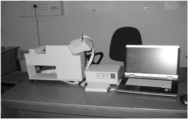 | Figure 1. High precision real-time multichannel spectropolarimeter with binary polarization modulation |
4. Identification of Pollutants on the Water Surface
- The problem of detection and identification of the pollution spots on the water surface, especially of oil spills, is being solved by many scientists. The recently developed technology of an adaptive identification of the environmental elements from measurements in the visible spectral region permits to synthesize an expert system for an adaptive identification of the environmental parameters (ESAIEP). The system’s structure includes a compact multi-channel spectropolarimeter (MSP), information interface with computer (IIC), computer software (STW), and extending database (EDB). The STW realizes a number of algorithms to process the data fluxes from MSP and provides service functions of visualization and control of the regime of measurements. The EDB consists of the sets of standard spectral images of the spots of pollutants represented by points in the multi-dimensional vector space of indicators, pre-calculated on the basis of learning samples.The principle of the ESAIEP functioning is based on fixation of changes of the light flux at the MSP output and their transformation into a digital code. Further processing of these data with respect to their efficiency is determined by the STW composition containing various algorithms of recognition of 2D objects. The adaptability of the recognition procedure is determined by the level of accumulated knowledge about special features of intensity fluctuations and polarizing properties of the light reflected from the water surface. The STW includes the means that make it possible, in case of uncertain identification of the pollution spot, to make an expert decision based on the visual analysis of its spectral image. This procedure is realized in the mode of dialogue with ESAIEP, and if decision is made, the operator can fix it in the database in the form of a standard for subsequent situations of an appearance of similar spots. The principal scheme of the STW unit providing the procedure of identification is some transformation Φ. The light intensity ξ ij recorded at the time moment t i in the channel λ j is evaluated by the algorithm Φ where two hypotheses H0 and H1 are identified. The ESAIEP operator determines initial data vi, α and β and decides of which parameters ui = (u1,...,ur) will be calculated from measurements of {ξ ji}. The service unit IIC makes it possible to form vector u i from statistical characteristics of the series {ξ ji} or to use direct measurements. A-priori information characterizes the type of distribution f a (u i). The function
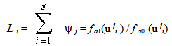 is compared with its ultimate values L i,min and L i,max At the first stage, these values are chosen arbitrarily, but then they change till reaching a maximum accurate recognition of the hypotheses H0 and H 1. We have L i,min → L*i,min and L i,max → L*i,max . The values L*i,min and L*i,max are memorized in EDB.After the learning procedure, the functioning of the expert system is limited only by the volume of measurements fixed by the operator, proceeding from statistical reliability and the real-time regime. The operator has two possibilities to regulate this regime, establishing the volume of the series {ξ ji} or fixing the time of their accumulation. Usually the latter characteristic equal to 1 s is chosen. The operator is combined with the ESAIEP units through the man-machine interface IIC, which provides the selective control of operations in all units.In the presence of the oil film on the water surface the system analyzes its thickness, age, source and geometry. In this case most informative are series of measurements at wavelengths 398 nm, 439 nm and 480 nm. In the case of dissolved or suspended components in the water the system estimates their concentration and from the data in EDB on the hydrodynamic parameters of the water body, it calculates their spatial distribution using the methods of 2D images processing.
5. Conclusions
- The results given in this paper illustrate how combined use of spectroellipsometric measurements and recognition algorithms give a possibility to to have operative monitoring of the water surface both in natural and laboratory conditions.