Hemalatha Ramakrishnan
Management,Christ University Institute of Management, Christ University, Bangalore, 560 060, India
Correspondence to: Hemalatha Ramakrishnan, Management,Christ University Institute of Management, Christ University, Bangalore, 560 060, India.
| Email: |  |
Copyright © 2012 Scientific & Academic Publishing. All Rights Reserved.
Abstract
This research paper has made an attempt to investigate the position of Bangalore Development Authority in acquiring increased quantum of land for the development of Bangalore city. Much of its policy efforts have been put to reality based on its efficient planning under various schemes. The paper has discussed the different schemes during various years, as a constant endeavour of city reach. Identification and conversion of village locations in expanding the city limits clearly reveals gainful development. Expansion of the city has been much in coordination with other local administrative undertakings. However, certain impediments have been well administered, results reveal more and more conversion of villages under different schemes have pushed opening out limit of the city growth in a spectacular manner.
Keywords:
Acquisition, Schemes
Cite this paper: Hemalatha Ramakrishnan, Acquisition of Land and Development of Bangalore City, American Journal of Economics, Vol. 4 No. 1, 2014, pp. 23-33. doi: 10.5923/j.economics.20140401.03.
1. Introduction
This paper attempts to understand the acquisition of land by Bangalore Development Authority. The main aim of the development authority is to ensure equitable distribution of land among growing population. Its purpose is not only to acquire land but to ensure that there is justifiable development in the allocation of schemes and in distribution of layouts. The paper is divided into two sections, the first section will explain how land is acquired and secondly, the research study will discuss the perception of sample household on acquisition of land from the Development Authority and how over a period of years owners have gained profitable appreciation in land value. There are practical delay in acquisition process and how the development authority has been successful in coordination with other administrative departments. The study has explored how the shift in administrative undertaking from City Improvement Board the development of city has taken place. This is evident that the city has progressed during various periods from 1960 to 2000. Prior to 2000 much attention has been towards development of special economic zones and infrastructure development. This has caused a gap meeting the growing needs of housing sector and as well unforeseen infrastructure delays. However, the latest trend of the city administration seems to be active in fulfilling the demands of realty and retail. Therefore, this paper would reflect on the schemes and the corresponding development through gainful land acquisition that has enhanced the inner as well outer growth of the city. analyzed.
2. Methodology
The study has used secondary source of data collected from Town and Country Planning Department and as well from Land survey department. To measure the various parameters calculation of average percentages is applied.
3. Review of Literature
1Louis A Rose and Summer J La Croix[4] in their case study have studied that the supply and demand for land and discussed land prices. The goal was to study the land price in Honalulu city and the methodology of regression results confirms that natural and institutional constraints restricts the supply of land and play an important role in determining price. He has made a comparison between demand conditions and ascertained the strength of factors causing high prices. The four demand variable population, population growth, amenities and income has been the cause for rise in land price.2Peter Colwell and CF Sirman[6] in their study have found that the hypothesized relationship between value and lot area gives rise to the potential for plottage and plattage. Plottage is a well known term for the additional value which is obtained by assembling two or more contiguous lots. If plottage exists the value of the whole is greater than the sum of the value of the parts. Plattage may be defined as the additional value which is obtained by deciding a lot into two or more smaller lots. In this case the value of the sum of the parts is greater than the value of the whole. Plattage may exist in the same market as plottage only over a different range of lot areas. For example value declines more between zero and one mile than between one to two miles. The time of sales is another important determinant of land value. The author has assumed in his study that land value is a increasing exponential function of time. That is, there is a constant rate of appreciation in land value. 3Alan A Walters,[1] in his article has asserted that the price of land is too high and has risen (or is rising) too rapidly. In less developed countries (LDCs) in the context of these statements one would normally understand that the complaints are directed against urban area. They are not normally applied on land in rural areas which are likely to remain long in pastoral use. The complaint is usually the joint one that prices of land are too high and have risen too rapidly. These are two quiet distinct allegations—one about the level of land prices relative to the level of other prices, and one about the rate of appreciation of land relative to the rate of appreciation of other goods or assets. The choice of the asset holder is between holding his wealth in the form of land or in some other asset such as bonds, or real capital. Each form of asset has an expected rate of return consisting of an income and an expected appreciation of price. In his comparison of asset value with un serviced land value, he discusses that non-urban land is not homogeneous and is of course affected by the spread of the city. Comparison of urban land usually includes services such as water, sewerage electricity and roads, and that the value or urban land will reflect the relative scarcities of these facilities. And even un serviced urban land will have prices that reflect the likelihood of services being installed. He has further discussed that the value of land in terms of income or wealth in terms of poor as a standard with the rate of growth. The acquisition of land as an asset should be in the interest of the poor. The rate of return on land is low because of the expectation of a rapid appreciation in price, it may well be in the interests of the poor to hold other higher yielding assets, such as stock in trade, and to rent living space. In assessing the impact of higher land prices on the urban poor, one must assess the extent to which they can substitute other things such as plentiful labour and capital for land to provide” low-cost” shelter.4Alan A Walters[4] has interpreted that changes in the annual opportunity cost will be brought about by changes in the price of the output of land relative to the general level of prices. Changes in the prices of inputs into land oriented activity relative to the general level of prices. Changes in applied technology in land related industry and, changes in the laws and regulations and other constraints on the use of land. These will reflect the variations in the productivity of land due to changes in preferences, changes in production and technology and changes in the legal and regulatory environment. Although easy to state the principle of opportunity cost involves some conceptual and many practical puzzles.He has analyzed the significance of the economic rent may differ from the opportunity cost because of mistakes due to the individual assessment being wrong. The usual indictment is that the prices of outputs and inputs that shape the economic rent do not reflect the social values of either resources or of outputs. They measure private profit and productivity rather than social values and aspirations. The deviations between social values and those values which would emerge in a free market are alleged to be large and significant. The cause of the difference between market or economic rent and the opportunity cost is that differential taxes, subsidies or controls may be imposed by government. In most cases tax restrictions and rationing are meant to serve primarily other goals rather than to measure what government deems to be the divergence between private and social cost. But it is well known that unless a congestion levy is exacted from urban road users, the value of an accessible location will therefore be less than the true social value. Therefore the important externality-highway congestion- suggests that the market will considerably underestimate the rental value of urban land, the greater, the congestion the greater the underestimation of the value of accessibility. It is useful to have a nomenclature for the extent to which a landlord can acquire the true economic surplus generated by his property. The appropriation ratio is defined as: AR= net rent received / Net surplus generated. The appropriation ratio will never knowingly exceed unity and will presumably never be less than zero. The net rent received is therefore the product of the net surplus and the appropriation ratio. Over the years actual appropriation ratio varies that may hold same for a given year. There is correspondingly a series of expected appropriation ratios which are thought to apply in future years, and these obviously have a crucial role in determining capital values.5Muttur Renganathan Narayana[5] has found evidence on the globalization and urban Growth in Bangalore is based on two indicators namely internationalization of trade and internationalization of capital. While the former is measured by export trade as a percent of Gross domestic income in Bangalore and latter by Foreign Direct Investment inflow as a percent of Gross Domestic Income of Bangalore.6Parry[7] how land use and land price are determined in a free market. On the fringe there might be a conflict between urban use and some other use. Occupiers of urban land will normally pay rent to the owners, marginalism concept is taken from three angle one, is tenant and rent agreement renewable, second, tenant has to form his own expectation of marginal income, thirdly marginal income exceeding marginal expenditure. Certain activities benefit from proximity to other activities. Same is the case like office clients accountants music teacher are all people who place some importance of being accessible to the public and on having their windows or name plates notices by those who pass by. Largely clientele are from Central Business District to pay rent, charge higher fee or else more to less expensive premise at a first to a back room on a top floor a location with car parking were the location has reputation. Land value increasing rent manifesting upward rental obsolescence might presage building obsolescence either because the owner considered that a building devoted to a different land use would be even more profitable or because he wished to provide a new building with more floor space and amenities devoted to the same use and earning even higher income. Precise location of activities nature and timing of re-development are all closely related. Frequent re-development takes place after land has been sold to a new owner.The speed at which price changes hands and so to question about land values. Urban land usually carries associated building and services. Local laws may prevent a site from being used for certain purpose. Price is determined in the context of existing permitted uses. Land in the vicinity at a time when the availability if the land is known widely. The highest price will often be the actual selling price but sometimes a purchaser may be ignorant of local prices and will adversely pay more than he would have done. If the owner of some land receives an offer for it he will not necessarily agreed to sell. Offer is highest that he is likely to get in the next year or two and compares well with prices recently paid for similar sites he will still consider that he puts a higher value on the land than this market value. If one could make correct valuation buying and selling would become very difficult. Normally the price paid for a property is somewhat less than the purchaser’s valuation and somewhat more than the seller’s. Equality of valuation would turn oil into glue.Empirical studies of the relation between land prices and distance from the Central Business District have been few. One example is a study by Mills using data from Hoyt’s classic. One hundred years of Land values in 7 Chicago[3]. The constant term is the logarithm of land value at the city center. It shows that the value has increased over time. The second term shows the amount by which land values decrease with each mile from the centre. In each case the amount of the value decreased with distance is shown to be significantly different from zero. 8Archarya G.S[2] in an article “ cities of India” ( sociological bulletin march 1953) confined his survey of the progress to cities a population of over one lakh designating them “ great values” to distinguish them apart. He also used them “supercity” to designate a city with a population over three lakh.
4. Acquisition of Land and Development of Bangalore City during 1960s to 2000
Bangalore Development Authority plays a significant role in development of Bangalore city. Its major functions are acquisition of land, provision of sites and services, creation of city infrastructure, planning and orderly growth of the Bangalore city. To acquire land in any part of the periphery location there are certain procedures that is followed: first and foremost is land notification. The Bangalore Development Authority announces in consultation and co-ordination with Revenue Department, City Municipal Corporation and the local government Thasildar. The authority ensures that land notification is published in Karnataka gazette. And this announcement furnishes details of year of land acquisition, survey number, name of the agriculturist one who has sold, boundaries, acres of land, property value and time with date. In the Extension of possession of land including government land Thasildar and local authorities are very specific as per records of rights of maintenance where ever land is unwarrantedly taken or utilized without government permission then the government has every right to acquire that land. Extent of land under court litigation is at the time of acquisition of land whenever the citizens or the owner of land is unsatisfactory or not willing to part with land or not satisfied with compensation then the Bangalore Development Authority takes it to the notice of civil court and then proceeds for litigation settlement. It was told that 99% of the land compensation is acknowledged and the development authority succeeds in gaining the land. Extent of built up land is depending upon the space of land that has not been used and depends upon the age of the building. De-notification is the decision taken by the government deemed to be fit that is not suitable for layout development but would be sold for other activity as well. Extent of land left out for other reasons is when preference for private have been allotted, for development of land by the Bangalore Development Authority. This is finally distributed in order to meet the demand of private builders including co-operative societies, industrial layouts, commercial undertakings, housing boards etc.As per 16/(2) notification actual possession of land is done and acquired in order to form the layout First survey is conducted, public is made aware through preliminary notification, investigation is carried out in order to assess the activity carried out, after this dispute, allegations and ownership will be cleared. And finally reward and incentive will be decided by the committee headed by assistant commissioner, revenue department, secretary in charge, sale deed department and engineering department. Based on the above procedure the study would like to reflect upon land acquired by the Bangalore Development Authority.
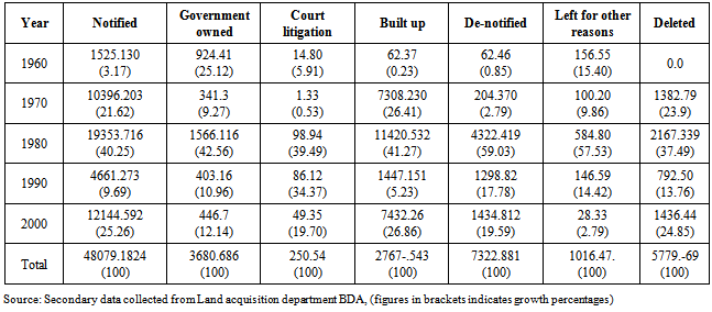
4.1. Table 1
Table 1 reveals the consolidation of acquisition of land by the Bangalore Development Authority from 1960 to 2000. The classification also explains about the different levels of acquiring land. There are seven stages at various levels, land gained by the Bangalore Development Authority. The extent of notified land is totally 48079 acres and 1824 guntas. To view the average growth to total land acquired the maximum land is gained mostly in the year 1980 it is 40.25% in acres and 39.25% in guntas. After notification the extent of land acquired including government land is 3680 acres and 686 guntas. The average acres of land to total is 42.55% in the year 1980. The extent of land under court litigation due to value determination and activities carried out previously on land use indicates total of 250acres and 54 guntas that has been under problem of litigation. Reason is indifference to part as well quality of land cause delay. As per the classification during the study period, it was found that large quantity of land has been kept in stay with civil court for litigation and solvency. In this process the extent of land acquired by the government is 3680 acres of land to the total and in guntas is 686. Here also it can be inferred from the table that the highest ever gained land is in the year 1980. The average to total acres of land is 42.56% and guntas it is 56% to total. When the extent of land under court litigation the total acres of land is about is 248 and 54 guntas respectively. Over a period of five decades it can be seen that quantity of land under civil court is highest once again in 1980 that is 39.5% to total. Thereafter in the following years for over a period of 10 years the study finds that the litigation percentage has come down to 34% and 36% in the year 1990 and 19% to 70% in the year 2000. This is as per information gathered from senior officials in land department. When the court insists the development authority the defined land has to be acquired and the compensation for the same has to be made as per the classification of land that varies from cultivable land to wet, and dry land. The extent of built up land is 2767 acres and 543 guntas, as per survey carried out by the land department. During every successive years the build up area of land has already been acquired by private for residence purpose and for commercial operation. This could not be acquired due to growth in value and the acquired land is very high based on square foot where the private were not ready to part with. This is clear from table that the high percentage of land is 41.27% in the year 1980 and in the year 1990 and 2000 the extent of built up is 5% and 26% to the total land acquired. The extent of de-notified land is 59% in the year 1980 this has been additional that the government has been able to gain excess over and above the notified land area. In the year 1990 there has been fall of 17% and has shown a rise of 19% in the year 2000-03. The government has acquired less qualitative land in terms of guntas that does not have expected quality as well that is not suitable for layout development. Due to scarcity of land and in order to cater to the growing commercial needs such land were not spared from gainful attempt. The reason for some of the site under de-notified classification is the Authority makes an attempt to put them for productive use so that even such excess land can be used for development of further commercial purpose or utilize for itself to start with administration centres and hire the building on lease / rent basis. Based on the operational function of the Bangalore Development Authority not only acquires but has the right to possess the land for its own ownership purpose to extend undue service in terms of planned city. Moving on, to the process of acquired land out of which the land that has been deleted for other reasons is distributing land for various other groups like co-operative society, industrial layout, organizations, private industrialist, corporates and other stakeholders need to take approval from the BDA. In this out of total land of 1016 acres nearly 584acres of land is distributed for private groups for development of residence and layouts as per the location of industries. From the table it can be inferred that the extent of available land left for other reasons within the city has come down to the level of 14% and 2% in the year 1990 and 2000. The quantity of deleted land is on account of un-classification and for the development of other links that does not accrue to the revenue receivables. In some situations the deleted land has been on account of social cause responsibilities and for informal sector development like slum clearance, roads, link paths, parks etc. The extent of deleted land for the five decade period is again showing a rising trend and then falling during the mid period, thereafter it has risen marginally. The table reveals during the initial period in 1960s there was no deleted land. In 1970s out of total of 5777 acres of land 1382 acres of land has been deleted (nearly 23.9%) In 1980s 2167 acres of land has been deleted to the extent of 37.51%. It can also be inferred that the extent of acres of land deleted in the year 2000 has increased to 1436 acres, in percentages 24.86%. Having observed the consolidated information of land acquisition for a period of five decades, the study would look into the acquisition of land development based on various schemes.Table 1. Acquisition of land by the Bangalore Development Authority during the period 1960 to 2000 (in acres/guntas)[9]
 |
| |
|
4.2. Table 2
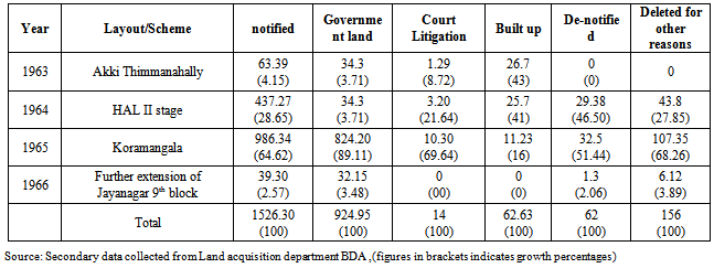
Table 2 explains the acquisition of land by City Improvement Trust Board and by Bangalore Development Authority during 1960s. The table also explains the various schemes developed by the Bangalore Development Authority in the year 1960s. During the beginning of the year in 1960s when the city was in the hands of City Improvement Trust Board four schemes were developed and the city was planned and has been upgraded in the name of different schemes or layouts like Akki Thimmanahalli, Koramangala, and Jayanagar. The highest land acquired was in Koramangala with 986 acres of land been for public notification implying a sharp rise and participation of city development authority. In the year 1965 out of total of 1526acres of land the maximum has been gained for development of koramangala scheme with 64.66%. Secondly HAL II stage scheme with 28.67% acquiring 437 acres and 27 guntas. Thirdly, is Akki Thimmanahally scheme with 63acres and 39 guntas respectively. The last scheme is the extension of Jayanagar 9th block with 39acres and 30 guntas. During every consecutive years from 1963 to 1966 it can be observed that maximum land is acquired and developed in Koramangala and at the same time the government possession of land is also maximum of 924 acres of land and 41 guntas, this exhibits a remarkable development of government administration The table reveals that the extent of land under court litigation is less with 14 acres of land and 80 guntas. This shows the problem of negotiation and settlement was less problematic, process was not much cumbersome and no delay. When we analyze the maximum built up area 62 acres and 37 guntas and in this HAL II stage occupies 41% and Akki Thimmanahalli 43%. This clearly indicates that the development process in the year 1960 was gradual slow and maximum effort by Bangalore Development Authority to acquire land in establishing government operations and in planning several layouts for residences purpose has been successful. This statement goes to say that the government has been able to gain an extra land over and above of 62acres and 37 guntas and in de-notification process also the authority has been able to acquire to the level of 62 acres and 46 guntas. In the final process gaining land for the extent of land left out for other reasons is 156acres and 55 guntas. This portion of land is been distributed for private participation in the development phase of housing, industrial buildings, group housing. Again here the table reveals that maximum land is achieved in koramangala and HAL II stage. In the entire process it is evident that not much land is left idle or deleted in Akki thimmanahalli scheme. During this year there has been fuller utilization of land for all purposes and as well in acquiring land was maximum and an overall achievement.Table 2. Acquisition of land by the City Improvement Trust Board during 1960s[9]
 |
| |
|
4.3. Table 3
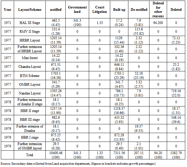
Table 3 reveals acquisition of land by the Development Authority during 1970s. In the year 1970s it is observed that there is a natural expansion of the city in all direction from the Central Business District, as well the total acquisition of land has increased to the level of 10400acres. Totally 15 schemes have been developed. In 1971 one scheme was developed by City Improvement Trust Board. During this period the administration and the responsibility been shifted or transferred to Bangalore Development Authority from the same year the speed of development has been active and several layouts in surveying the areas has been very extensive. Therefore, hence it can be seen nearly eight layouts has been developed in the year 1977 like ,Old Madras Road, Hennur Banaswadi road, Nandini Layout, RMV layout, HAL III stage, Chandra layout, BTM layout and several extensions have also taken place based on scheme and availability of land. The maximum land is acquired from BTM stage with 1703 acres and 10 guntas, Secondly from Nandini Layout with 1505 acres of land and 26 guntas, then comes HRBR layout with 1205acres and 14guntas in the year 1977 and in the year 1978 three schemes with the expansion of II and III stage of HBR layout, we can see from the table another 1237 acres, plus 982 acres of land and 14 plus 6 guntas of land has been acquired. Finally in the year 1979 again three schemes were recognized namely domlur, OMBR layout and HBR I stage gaining nearly 18acres,875 acres and 29 acres of land. During this period a non – stop rigorous attempt continued by the Bangalore Development Authority to gain extra land in order to expand the defined layout to a greater extent. In this level it can inferred that the additional land that has been developed to the level of 875acres and 25 guntas in HBR, then in OMBR layout 29 acres. During this period the government was merely able to acquire about 341 acres of land and 3 guntas. To view the quantity of land under court litigation there was a loss of 1 acre and 33 guntas.The quantity of land acquired and the extent of built up acres of land gained, in the gap of five years (i.e. 1966-71) the city is competent to grow with buildings raised by private participants. With more private participation in land development and this is especially happened in areas like HBR layout, OMBR layout, BTM layout mostly a team of influential groups. It can also be observed not all notified areas has been allotted for layout development but rather the private has been able to expand the city in their own way. From the total notified acres of land, the extent of built up is almost 7311 acres. The speed of development is high in BTM and HRBR layout. The development authority no doubt has been able to gain excess of land 207 acres and 370 guntas in the de-notification process and mostly from areas like BTM 52 acres, domlur19 acres The study interprets that not much has been acquired during this year. In most of the cases nearly 30% has gone without saying for built-up area when we analyze from the notified acres. The extent of left for other reasons was only 94.20 acres and that was left for development of HAL III stage and 6 acres in HBR layout II stage. The total deleted land were 1382 acres and 79 guntas in this year, mostly in HRBR layout, Chandra layout, Nandini layout,HBR layout II and III stage. Nearly 25 acres to 720 acres in Chandra Layout and in Nandini layout were left for commercial, staff quarters for bankers and for other development in order to bring about good connectivity of orderly path to outer ring road in different directions to reach Central business District. Table 3. Acquisition of land by Bangalore Development Authority during 1970s (in acres/guntas)[9]
 |
| |
|
4.4. Table 4
Table 4 explains the acquisition of land by Bangalore Development Authority during 1980s. In the year 1980s nearly 31 schemes were recognized. About 19353 acres total land and 716 guntas was acquired The following schemes as per year to mention is that two schemes in the year 1980 that is further extension of OMBR continued with 341 acres of land and 18 guntas were augmented that was left in the previous year. In the year 1982 West of chord Road and Nagarbhavi acquiring 19 acres and 1210 acres of land Simultaneously augmenting 35 and 38 guntas left previously were gained these were the new locations developed during this year, In the year 1983 further extension of RMV II stage continued that was left in the previous scheme in the previous year acquiring 131 acres and 33guntas. In the year 1984 four schemes were developed. Development of STBed 358 acres and 32 guntas, east of NGEF about 588 acres and 13 guntas and HSR layout 1425 acres and 20 guntas. In 1986 two schemes namely NGEF and HSR layout land development was augmented from the previous year gap that was left out. Totally 466 and 1664 acres of land and 19 and 21 guntas was acquired. In 1987 nine schemes were developed other than the old recognized schemes the new areas were Sajjepalya, Srigandadakaval, Challagatta scheme, Banashankari and JPNagar while all other schemes were developed with much interest and were taken in augmentation of previous land. Development continued in surveying and identifying further extension of areas.Table 4. Acquisition of land by Bangalore Development Authority during 1980s (in acres/guntas)[9]
 |
| |
|
Among the new locations that was identified the increased land area that was gained is 1047 acres and 6 guntas from Srigandadakaval location, followed by JPNagar VII stage with 892 acres and 34guntas, BTM 805 acres and 21 guntas, BSK IV stage 606 acres and 19 guntas, further extension of HSR layout 748 acres and 29 guntas and lastly Sajjepalya with 225acres and 31 guntas Challagtta scheme with 24 acres and 25guntas.The next phase of acquisition is in the year 1988 identified in the survey rounds of six schemes namely the two new locations were Laggere and Venketeswara while all other areas were JPNagar VII stage and IX stage , BTM 4th stage and Shivanagulu Tank Bed. The maximum land that was acquired was 2339 acres and 50guntas in JPNagar club together for development of VII and IX stage. Second is Laggere with 1071 acres and 24guntas. Third is BTM 397acres and 13guntas and fourthly is Shivanagulu Tank Bed with 293acres and 12 guntas Finally Venkatewara recorded with 209acres and 4guntas.Coming to the last phase of development in the year 1980s is five schemes were surveyed and developed namely Jnanabharathi, Banashankari III and V stage, Hoserakarahalli and development of Kanakapura village. The highest land that was surveyed and acquired is in BSK V stage with 1851 acres and 39guntas, second is Jnanabharthi with 900 acres and 30 guntas, BSK III stage 389 acres with Hoserakarahalli upgraded with 154acres and 39guntas and for development of link road 173acres of land and 43 guntas was acquired.The total land acquired for government possession in 1980 was 1567acres and 116 guntas. In this major share was gained from HSR layout, NGEF east and OMBR layout. In HSR layout about 1120acres of land 32guntas was gained accounting to 71% to the total. Then in OMBR layout with 244acres and 44 guntas accounting 12% to total and east of NGEF with 194 acres and 23guntas adding 12% possession to the total. In order to acquire this maximum land much, the civil court has helped with much effort and support to the Bangalore Development Authority to gain. During this year about 98acres and 93guntas was in civil court for litigation. Mostly from NGEF east, Shivanagulu Tank Bed,OMBR layout and from HSR layout the litigation issues had been successful and government has proved its efficiency and rigour in achieving its target. But however, land space in the east of NGEF has to be resolved and the factory has been wound up due to operational issues.In1980s the extent of built up area was 11427acres and 520guntas. Among the various locations the maximum built up area that got expanded is in Banashankari V stage with 1865acres 93guntas of land, followed by HSR layout with 1664acres and 21guntas, Nagarbhavi with 1124acres 39guntas, JPNagar with 1111acres 36guntas and finally OMBR layout with 75acres 20guntas. Total de-notified land is 4322acres 419guntas where the excess land that was de-notified because of non-feasibility of layout development were mostly in BSK V Stage, JPNagar VII stage, BTM III stage. Minimum de-notified acres was from 376 to 1458 in the above mentioned areas. The extent of left out space for other reasons were 584 acres 80 guntas and total deleted land was 2167 acres and 339guntas.
4.5. Table 5
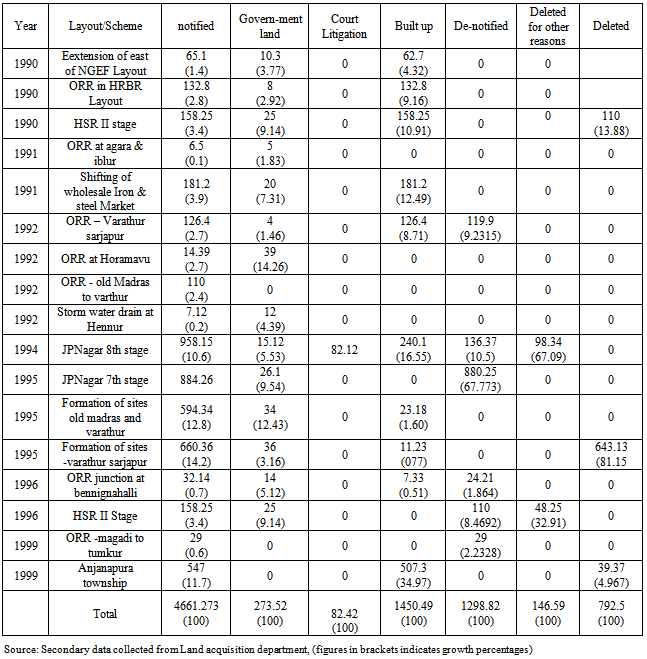
Table 5 explains the acquisition of land by Bangalore Development Authority during 1990s. The above table reveals the progress of the city at increased level in the year 1990s. Land acquired in the year 1990s is 4661 acres 273guntas. Totally 17 schemes were developed during this year. Three projects in the year 1990 namely extension of east of NGEF layout, Outer Ring Road in HRBR layout, HSR II Stage, two in 1991 Namely Agara Iblur, Iron and steel shift, four in 1992 namely Varathur Sarjapur, Horamavu, Old Madras road, Hennur, one in 1994 JPNagar, three in 1995 all these are extension work of the above schemes , two in 1996 Bennignahalli, HSR II stage, and two in 1999 Magadi to tumkur, Anjanapura township. During this year more than allotment of sites/schemes the study reveals that much emphasis was given for development of infrastructure. In order to decongest crowding and migration outer ring road connectivity was developed . There were three locations that was surveyed and developed for residential purposes like JPNagar 7th stage and 8th stage and Anjanapura township. Other than these identified conversions of villages to city limits rest of the land space were all extended further like east of NGEF, HRBR layout, HSR layout. The maximum development was for ORR(outer ring road) and the bulky acres of land was acquired for Sarjapur, Varathur ring road about 660acres of land was acquired and again 594 acres of land was acquired for linking Old madras road and Varathur road (due to many IT companies emerged). Among the layouts the maximum acres of land gained was in JPNagar 7th and 8th stage with 854 acres and 958acres of land. While in Anjanapura 547aces of land were gained. Extension possessed including land under court litigation is 403 and 86 acres of land while that of extent of land built up is 1447acres and extent of land de-notified is 1298 acres, land deleted for other reasons is 146 acres and total deleted land is 792 acres.Table 5. Acquisition of land by Bangalore Development Authority during 1990s (acres/guntas)[9]
 |
| |
|
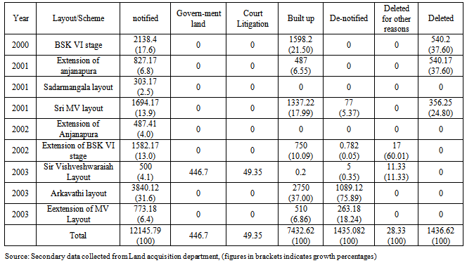
4.6. Table 6
Table 6 explains the acquisition of land by Bangalore Development Authority during 2000. Total land acquired in 2000 to 2003 is 12145acres and 502guntas. Nine schemes were developed during this year. New locations were Vishveshwaraiah layout, MV layout, Sadarmangala layout and Arkavathi layout. Among these layouts maximum acres of land was allotted for Arkavathi layout with 3840acres 12guntas, secondly MV layout with 1694acres and 17 guntas. Rest of the land space were utilized for further extension of BSK VI stage, MV layout and Anjanapura. The extension of land possessed by government was 446acres 7guntas from MV layout, extent under court litigation was 49acres and 35guntas, extent built up area is 7432acres26guntas, de-notified land was 1434acres 812guntas , extent left for other reasons was 28acres 33guntas, while deleted land was 1436acres 44guntas. Table 6. Acquisition of land by Bangalore Development Authority during 2000 (acres/guntas)[9]
 |
| |
|
Hence, it can be summed up Bangalore City has gained more priority in conversion and expansion of its geographical boundary limits acquiring large acres of land. The Development Authority have been leaping like a frog in its survey of vacant land, therefore the study has been to reflect the efficacy in the execution of various schemes.Limitations of the study: is that in the process of compiling data there were inconsistency gaps noticed during survey rounds missed and has impacted the frame of appropriate hypotheses testing. Descriptive test reveals that there is a gap in the series of data and graph does not show fruitful results. Hence the study is compelled to use average percentage calculation.
Notes
1. Louis A Rose and summer J La Croix, Urban Land price, the extraordinary case of Honolulu, Hawai Urban Studies, vol, 26 (1989) Pg.301.2. Peter Colwell and C F Sirman Area time, centrality and the value of land Journal of land economics 1978 pg 514-519.3. Alan A Walters Value of Urban Land, A prologue, The rise in the Value of land, Urban projects department, World Bank Washington, Times Research foundation 1982 page 24-79.4. Ibid page 37.5. Muttur Renganathan Narayana, Globalisation and urban Growth evidence for Bangalore, Faculty of Economics, University of Tokyo and Institute of Social and Economic change, Bangalore 2008. 6. Parry Rent of land for warehousing and industry are similarly determined. Based on location and base period Land rents, values, prices and use page 151.7. Edwin Mills “ The Value of urban Land” in Harvey perioff the Quality of the Urban Environment for Resources for the Future Inc., (Baltimore Johns Hopkins 1969) pp 231-253. Homer Hoyt One Hundred Year of Land Values in Chicago ( Chicago University of Chicago Press 1933.8. Archarya G.S Some thoughts on urbanization century second most serious problems” Yojana September 13, 1964, volume-VIII, No.18, page-11.
References
| [1] | Alan A Walters Value of Urban Land, A prologue, The rise in the Value of land, Urban projects department, World Bank Washington, Times Research foundation 1982 page 24-79[(1-2)]. Ibid page 37. |
| [2] | Archarya G.S Some thoughts on urbanization century second most serious problems” Yojana September 13, 1964, volume-VIII, No.18, page-11. |
| [3] | Edwin Mills “ The Value of urban Land” in Harvey perioff the Quality of the Urban Environment for Resources for the Future Inc., (Baltimore Johns Hopkins 1969) pp 231-253. Homer Hoyt One Hundred Year of Land Values in Chicago ( Chicago University of Chicago Press 1933. |
| [4] | Louis A Rose and summer J La Croix, Urban Land price, the extraordinary case of Honolulu, Hawai Urban Studies, vol, 26 (1989) Pg.301. |
| [5] | Muttur Renganathan Narayana ,Globalisation and urban Growth evidence for Bangalore, Faculty of Economics , University of Tokyo and Institute of Social and Economic change, Bangalore 2008. |
| [6] | Peter Colwell and C F Sirman Area time , centrality and the value of land Journal of land economics 1978 pg 514-519. |
| [7] | Parry Rent of land for warehousing and industry are similarly determined. Based on location and base period Land rents, values, prices and use page 151. |
| [8] | Annexure Data classified by investigator - Town and Country Planning department, Bangalore Development Authority. |
| [9] | All tables - Classified table developed by investigator - Land in hectares data- Acquisition of Land Department Bangalore Development Authority. |
 Abstract
 Reference
 Full-Text PDF
 Full-text HTML