-
Paper Information
- Paper Submission
-
Journal Information
- About This Journal
- Editorial Board
- Current Issue
- Archive
- Author Guidelines
- Contact Us
Archaeology
p-ISSN: 2332-838X e-ISSN: 2332-841X
2018; 6(1): 6-11
doi:10.5923/j.archaeology.20180601.02

The Probable Lower Paleolithic Evidence from Darongar River, Dargaz, North Khorasan, Iran
Ali Sadraeil1, Mehdi Fallah Mehneh2, Mahmoud Toghraei3, Bahram Anani4, Mahya Azar5
1M.A. Graduate of Archaeology, Tarbiat Modarres University, Tehran, Iran
2Phd of Archaeology Torbat Heydarieh University, Iran
3Director of Bandian Research Center, Iran
4Phd Student of Archaeology, Art University, Isfahan, Iran
5M.A. Graduate of Archaeology, Neyshabur University, Iran
Correspondence to: Ali Sadraeil, M.A. Graduate of Archaeology, Tarbiat Modarres University, Tehran, Iran.
| Email: |  |
Copyright © 2018 The Author(s). Published by Scientific & Academic Publishing.
This work is licensed under the Creative Commons Attribution International License (CC BY).
http://creativecommons.org/licenses/by/4.0/

More than six decades have passed since the beginning of Paleolithic excavations in Khorasan, and despite the fact that this region is considered as one of the first centers of Paleolithic studies in Iran, after the studies conducted by Carlton Stanley Coon, no other noteworthy research has been carried out on the Paleolithic era of Khorasan, and those limited studies performed in this area of Khorasan have often been focusedd on open air sites located on the edges and dried basins of rivers such as Kashfroud. Among these findings, those discoveries obtained from the Dargaz dried riverbed are among the latest findings of the Paleolithic period in northern Khorasan, that despite having been severely eroded by water, according to the morphology of the artifacts, their tool making industry can be attributed to the lower Paleolithic period. The above-mentioned artifacts include a small collection of core chopper, single-sided simple cores, two-sided cores, heavy side scrapers, rough retouched flakes with, and simple flakes that according to the morphology and type of technique used in the mentioned collection, it could be reasonable to attribute it to the lower Paleolithic period. It is obvious that the collection was not an in situ one and its main location may have been probably located at higher elevations washed by flood flows and carried to this point, so that the effects of this displacement are also observable in the form of water erosion experienced by the most artifacts. In the present paper, it has been attempted to describe, morphologically study, and, finally, and analyze these findings using a comparative study and morphology of the artefacts.
Keywords: Dargaz, Lower Paleolithic, Khorasan, Daroungar, Iran
Cite this paper: Ali Sadraeil, Mehdi Fallah Mehneh, Mahmoud Toghraei, Bahram Anani, Mahya Azar, The Probable Lower Paleolithic Evidence from Darongar River, Dargaz, North Khorasan, Iran, Archaeology, Vol. 6 No. 1, 2018, pp. 6-11. doi: 10.5923/j.archaeology.20180601.02.
Article Outline
1. Introduction
- In spite of the systematic and extensive research on the Paleolithic period in western Iran, providing a relatively clear picture of the livelihood of hunter-gather societies and their tool making traditions in these regions, in eastern Iran, and in particular Khorasan, the condition has been completely different and very little information is available about the Paleolithic era and its tool making traditions. Daroungar river of Dargaz is one of the two important catchment basins in Dargaz plain, which originates from the southern calcareous altitudes of “Allah Akbar” mountain ranges and extends to the northwest along the Ghuchan-Dergaz road; and since this is a freshwater and permanent river, it has played a decisive role in the distribution of settlements (Garagian, 1998: 1; Yousefi Zashk and Baghizadeh, 2012: 7). Meanwhile, the sedimentation rate at the plain surface has been very high, so that at the wall section of Daroungar river that passes from the eastern border and flows to the south of the huge hill of Yarim Tape with a north-south direction, the cultural layers have continued at a depth of 5 meters from the plain area (Ga Azhyan, 1377: 87); and according to this sediment size in the plain, there is little hope of identifying open air sites. Nevertheless, during a short visit to Daroungar dried riverbed 2 km north of Yarim Tape and 1 km to the west of the village of Artian, on part of Daroungar dried riverbed placed there in the form of compressed alluvial deposits at the edge of the main river route, a small collection of artifacts was identified. The mentioned artifacts include biface, chopper-core, single-sided simple core, heavy side scrapers, rough and simple flakes, and retouched flakes. According to the techniques used and also the presence of significant artifacts from the lower Paleolithic period, including biface and chopper-core and the undeniable similarities with the samples obtained from Kashfroud site, including Gak castle (1) and Gezi bridge (Jamie al-Ahmadi, 2008: 111), and the presence of a two-dimensional artifact has increased the significance of the data. Considering the importance of the obtained data, which are among the little evidence indicating the presence of hunter-gatherer communities in the lower Paleolithic in Khorasan province, using comparative studies and morphology of the tools, the authors intended to describe the findings, conduct a morphological study on them and finally analyze them.
2. Literature Review
- Paleolithic studies in the white archeological region of Iran are still at the beginning of their way due to insufficient archaeological activities, lack of attention to the prehistoric period, and the dynamic and active geological conditions of Khorasan, and the little information available has been provided thanks to the review of brief and sporadic archaeological reports. Karlton Stanley Coon was the first researcher who conducted Paleolithic studies in Khorasan (1951 Coon). Thibault and Ariaei discovered 7 sites from the lower Paleolithic period in Kashfroud and attributed them to the pre- Acheulian industry (Ariai & Thibault, 1975). Also, in recent years, some Paleolithic sites have been identified and studied in different parts of Khorasan (Jamialahmadi, 2008; Jamialahmadi et al., 2011; Barfi and Soroush 2014; Nikzad et al 2015; Sadraeil et al. 2017) from among which only the examples obtained from Kashfroud dates back to the lower Paleolithic period. Therefore, in the final analysis of the collection, the authors have attempted to compare the samples gained of Daroungar dried riverbed with those of Kashfroud and then analyze the results.
3. The Geology Settings and Natural-Cultural Landscapes of the Area
- From the geological perspective, the Dargaz plain has located in the sedimentary zone of Kopet Dagh (Yosefi Zoshk and Baghi Zadeh 2012). From the sedimentological aspect, the sediment rocks of the region include limestone, Dolomite, conglomerate, sandstone, shill and Marne (Adabi and Mosavi Herami 1986). With respect to this fact that one of the most important sources to chert, is sedimentary rock, it can be assumed that the rock source of the stone tools of the region would have searched in the highlands, although the rubble of flint has been observed in the terrace of Darongar River which might have been used by hunter/gatherers who had no access to highland sources. Daroungar is the most important water source in the area. But, given the environmental potential of the area, no Paleolithic scatters was reported in previous research (Garazhian 1998; Yosefi Zoshk and Baghi Zadeh 2012). The artifact collection obtained from Daroungar is located at the geographical coordinates of ″22 2837 N and ″68684.8659 E and altitude of 573 meters above the sea level (Fig. 1) and one kilometer west of the village of Artian and 2 kilometers north of Yarim Tape. This site is situated on the edge of Daroungar dried riverbed, and includes a small collection consisted of 11 pieces of lithic artifacts, in some of which the degree of water erosion is very high, indicating their transfer from another place to this point of the plain (Fig. 2). Although this feature is one of the main features of the Sone Age open air sites, it is only after the matching process1 that one can discuss about the exact location of the data.
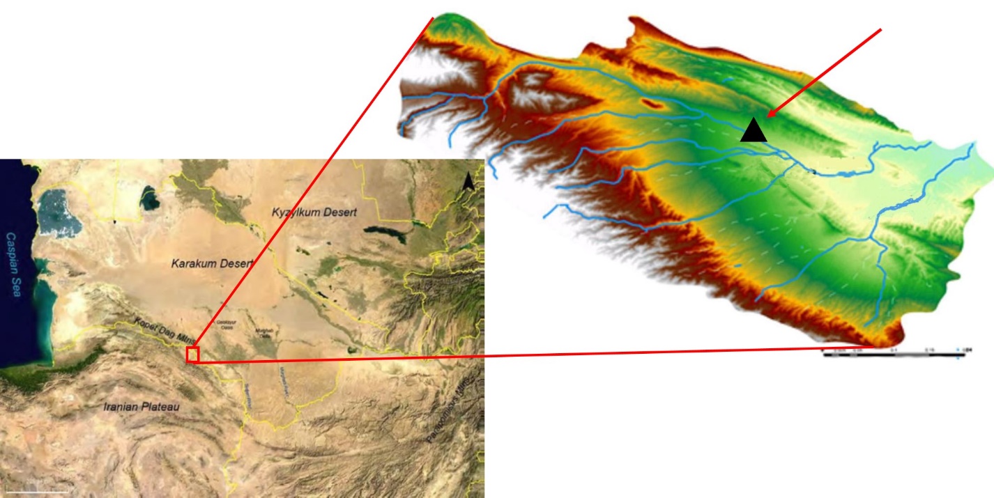 | Figure 1. Location and Topography of Dargaz Plain3 |
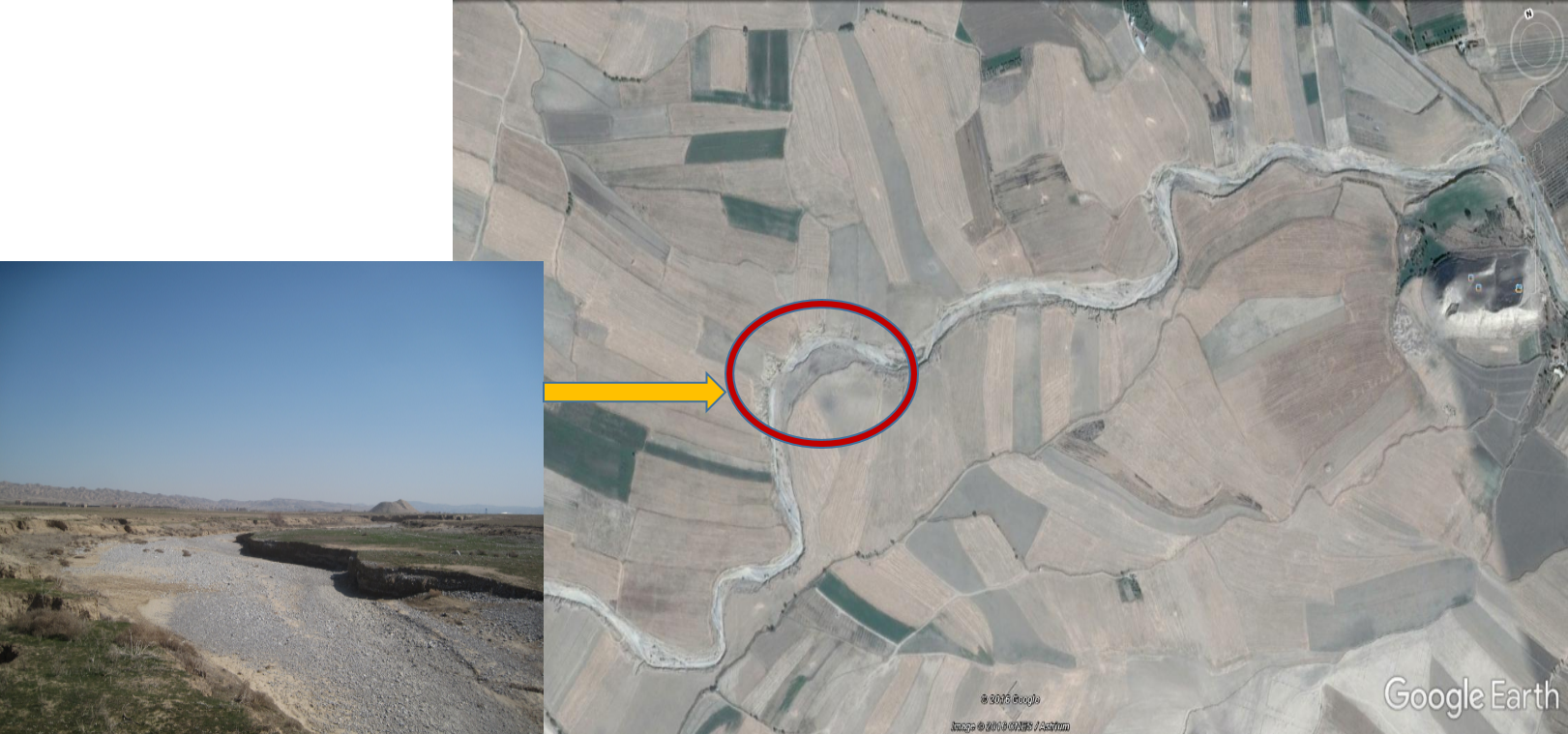 | Figure 2. Landscape of Daroungar dried riverbed and the discovery location of the artifacts |
4. Lithic Artifacts of the Dried Daroungar Riverbed
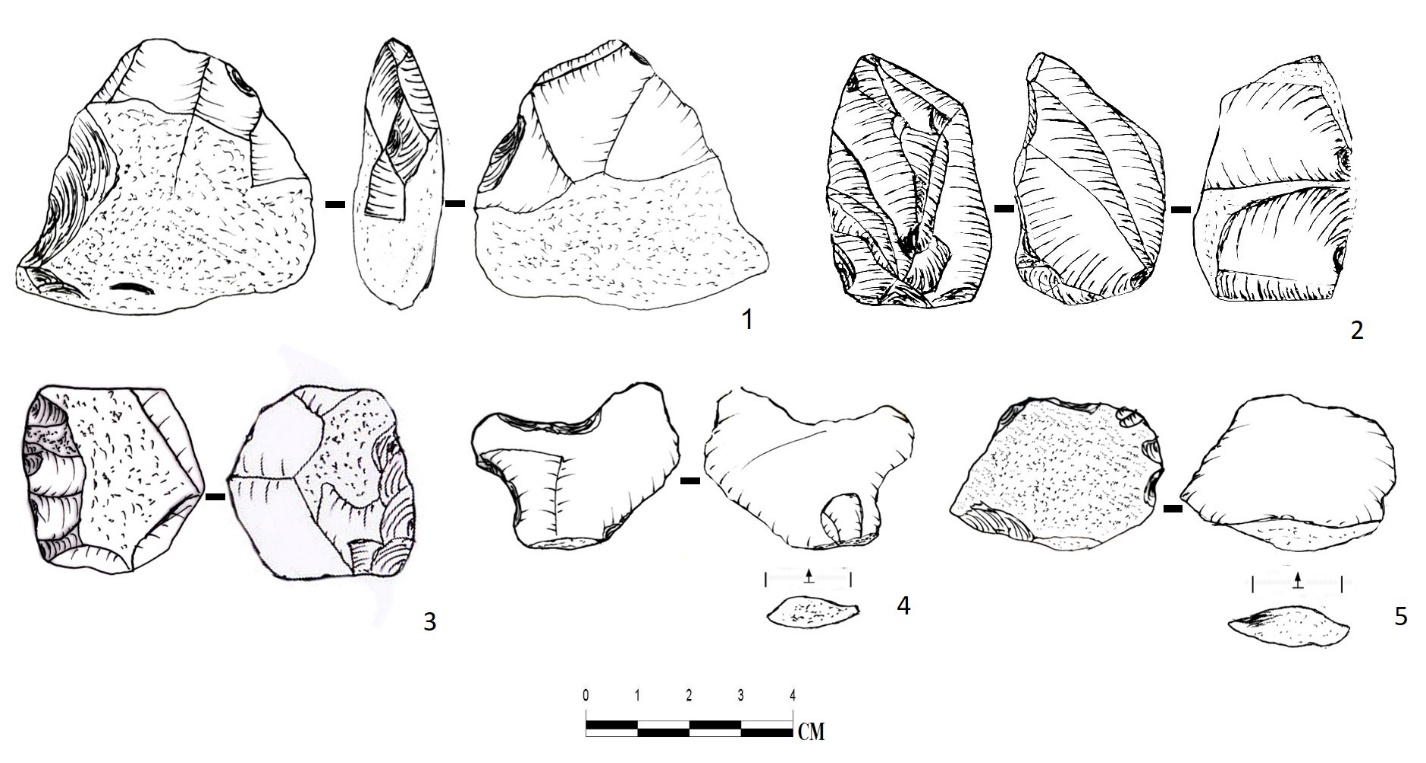
- The study area was approximately 150 X 100 m2 which was found on the edge of the eastern shore of Daroungar River, among the alluvial deposits accumulated along the river bed side. In some cases, the samples were identified at distances of more than 10 meters apart each other. The level of water erosion at the edge of the artifacts and also being placed among the alluvial deposits, which are not in situ, indicate that they have been transferred by floods from high altitudes to this part of the plain. In general, 11 pieces of stone tools2 were sampled during a visit to the dried Daroungar riverbed (Diagram 1 and Figures 3-5). These artifacts have been flaked from Chert stones ranging in color from light and dark brown to cornelian and streaky striped with low-to-medium quality (10); and medium-quality brown quartz (1). According to the type of the used stones and their small dimensions, and with reference to the abundance of Chert rubbles on Daroungar riverbed, one can assume that most important source of them may have had a local origin. The collection consists of simple one-dimension core (1), retouched core (1), chopper-core (2), a heavy side-scraper (1), a broken heavy scraper (1), retouched flakes (2), simple flake (2) and a biface, that the mentioned biface tool is among the few biface pieces found in Khorasan. This biface is 8.5 cm long and 3.4 cm wide, and there is 20% cortex3 (the primary cortex) on it. This biface, that have been squashed in some areas, is made of moderate quality striped flint, and flaking traces are seen in most parts of it, and therefore, it is comparable to the classic biface examples of the Acheulian industry, and it can significantly contribute to the relative dating of the artifacts. Generally, the high percentage of cortex in the artifacts (72%), as well as core and core pieces (36%) indicate that part of the artifacts related to flaking sequence can be identified in the collection, on the other hand, the lack of preparation pieces, chips and debris, and the water erosion experienced by most of the artifacts suggest that the findings are not produced in situ, thus according to the fact that the collection is situated among alluvial sediments of Daroungar river, it can be assumed that the aforementioned artifacts are part of an outdoor collection transferred to this point of the plain by flooding streams from the highlands which are washed away and carried here. The existence of single-side core, side heavy scrapers, as well as core cleavers is comparable to the collection obtained from Kashfroud (Jamialahmadi, 2008: 111). On the other hand, due to the presence of a biface in this collection, this collection is comparable with those found in Turkmen sites attributed to the second method of tool making during the lower Paleolithic period, i.e. the Acheulian method (Derevianko, 2005: 5).
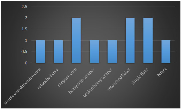 | Diagram 1. The Frequency Percentage Diagram of the Lithic Artifacts Tools (Image by the authors) |
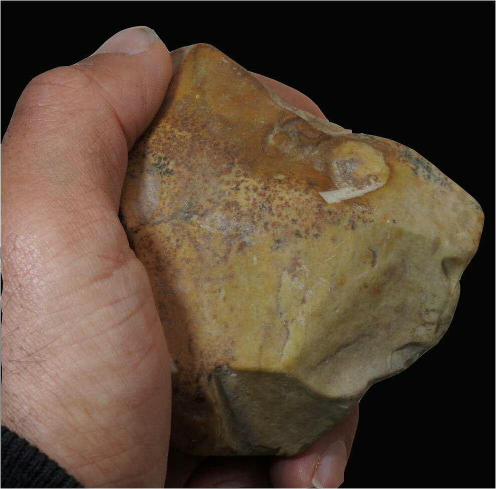 | Figure 3. Chopper- Core obtained from the dried Daroungar riverbed |
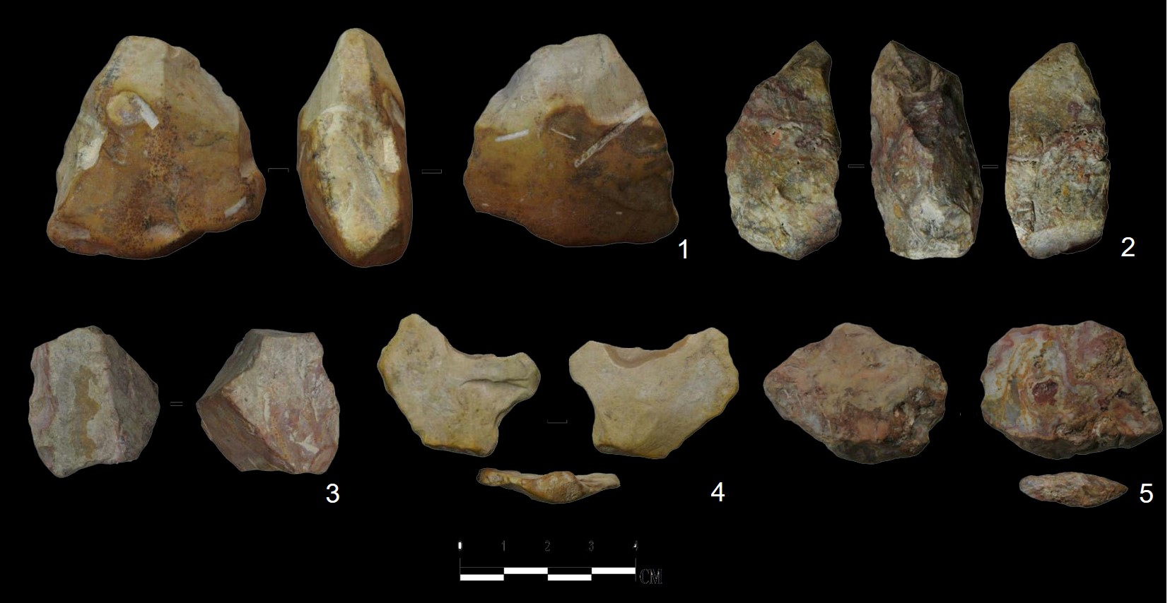 | Figure 4. A selection of artifacts obtained from the dried Daroungar riverbed: 1Chopper- core, 2 biface tool, 3 side heavy scraper, 4 and 5 rough flakes with lateral retouched |
5. Conclusions
- The artifacts obtained from Daroungar riverbed are among the few findings of the lower Paleolithic Period in Khorasan that provide some evidence indicating the presence of a tool making industry in this period. As mentioned before, the artifacts obtained from this collection include core cleavers, single-sided cores, core pieces, and heavy scrapers, flakes, and two-sided tools, that in terms of the applied techniques, including the presence of core cleavers and two-sided tools, we can find close connections with the sites discovered in Kashfroud. In the end, it should be argued that the obtained collection is not an in situ collection, rather it can provide important evidence of the presence of hunter-gatherer communities in Dargaz plain for the first time, emphasizing the need for conducting specialized research in this area so that through these kinds of studies a large part of the long history of hunter-gatherer communities’ presence in this part of Iran can be identified.
Notes
- 1. It is a process through which all the steps and sequences of flakes, such as core, cortical flakes, preparation of flakes, simple flakes, and debris can be identified.2. The terms "stone tools" and artefacts do not contradict each other, and the writers’ purpose of using them is only to prevent the repetition of a term.3. The original picture, which was edited by authors, has been obtained from Yousefi Zashk and Baghizadeh’s study (2012: 31).
 Abstract
 Reference
 Full-Text PDF
 Full-text HTML