Hassan Basafa, Mohammad Hossein Rezaei
Department of Archaeology, University of Neyshabur
Correspondence to: Mohammad Hossein Rezaei, Department of Archaeology, University of Neyshabur.
| Email: |  |
Copyright © 2014 Scientific & Academic Publishing. All Rights Reserved.
Abstract
Despite the strategic position and specific economic conditions of Khorasan province including location in the course of the route linking East to West and distinctive mineral resources, no integrated study has been conducted to date for understanding the prehistoric cultures in this province. Therefore, archaeological excavations in Chenaran site as a major site in Mashhad Plain can elucidate the dark archaeological aspects and chronological vacuum in this field. Chenaran site is located on the northern margin of the current city of Chenaran in Khorasan Razavi province. It was excavated in the summer of 2012. The main objectives were to estimate the extent of the prehistoric site of Chenaran and present relative and absolute chronology from the lower layers to the end of settlement, and fortunately considerable results in this field were achieved. In this paper, only the relative chronology results have been pointed, and it is hoped that absolute chronology results are independently released in another article, which is currently under consideration. According to the pilot study and in a comparative approach with the settlements in southwestern Turkmenistan, Chenaran site pottery is comparable with Anau Ia to Namazgah III period.
Keywords:
Chenaran Site, Cheshmeali Culture, Anu Culture, Namazgah Culture
Cite this paper: Hassan Basafa, Mohammad Hossein Rezaei, Evidence of Cheshmeh Ali Culture in Chenaran Plain (Northeastern Iran), Archaeology, Vol. 3 No. 1, 2014, pp. 10-15. doi: 10.5923/j.archaeology.20140301.02.
1. Introduction
Chenaran County is located in a distance of 55 Kilometer from northwest of Mashhad between Hezar masjed mountain range in north and Binalud in south (Figure 1). Chenaran plain with an area of about 3319 square kilometers is the largest lowland of Kashafrood river basin (Majid 2011, pp. 776) . Chenaran County is limited to Dargaz County from the north, to Mashhad from east, to Qoochan from west and to Neyshabur from south (Ghanbari 2002, p 5). The weather is hot in summer and cold in winter in Chenaran. The city has a mean annual precipitation of 250 mm (Hashemi-Attar, 2009). Agriculture and drinking water resources of this region include the rivers of Radekan, Akhlamad, Frizi, Golmakan, Ardak and Behmankan (Ghanbari 2002, p 44). Chenaran site is probably one of the most important prehistoric settlements in Mashhad Plain. Expansion of the current city of Chenaran is a serious threat for the limits and probably area of the site, and therefore the initial survey to determine the limits and area of the site seems to be necessary.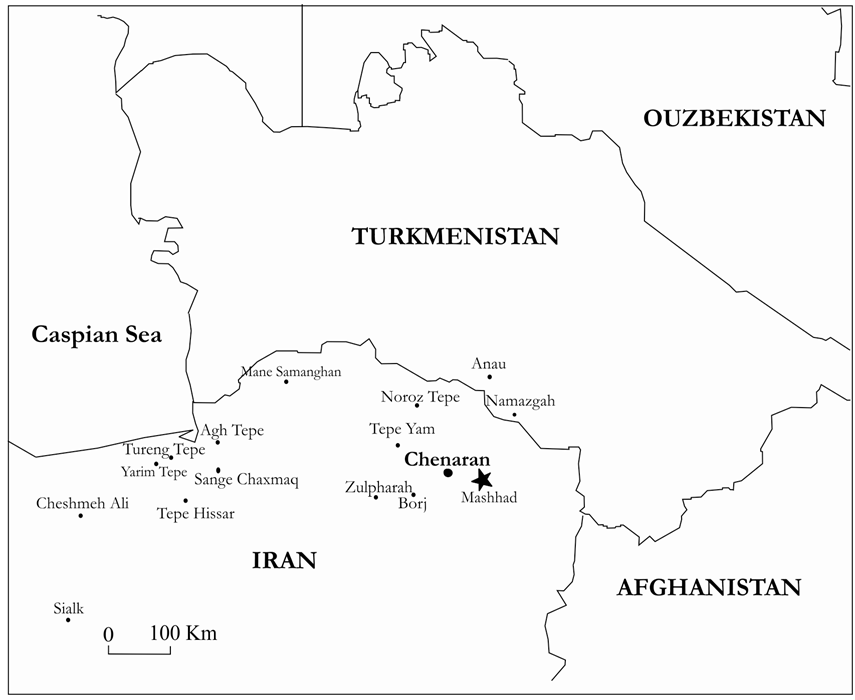 | Figure 1. Location of Chenaran Site and other Sites of Cheshmeh Ali Culture |
2. Topography and Description of the Site
This site is located in the northern part of Chenaran with an approximate length of 300 meters, width of 150 meters and an area of about 3 hectares (Figure 2). The site is oval-shaped, and has a height of about 10 meters from the surrounding land. Unfortunately, due to the expansion of Chenaran, limits and perhaps area of the site especially in the eastern part is subject to destruction.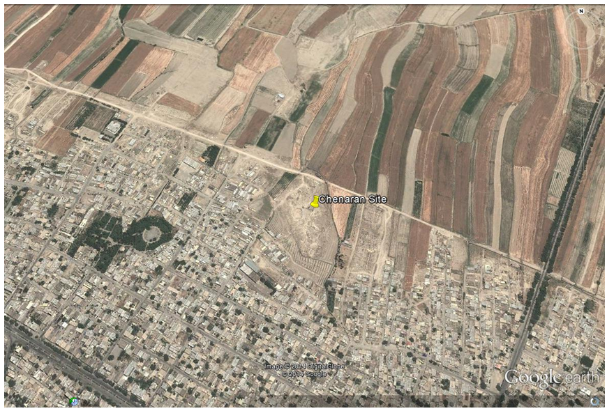 | Figure 2. Location of Chenaran Site |
3. Local Stratigraphy Trench and Excavation Method
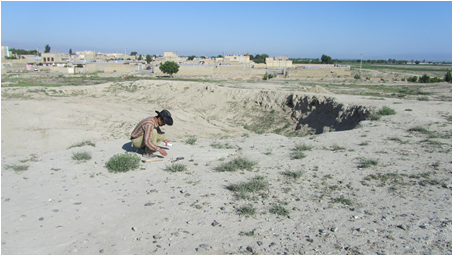
To determine the sequence of cultural periods as well as formation of natural and cultural layers and sediments in Chenaran site, a trench in the highest part of the hill with 3×3 m dimensions was explored for stratigraphy (Figure 3). The method suggested by Harris matrix was used in exploration, which is based on content and context of the layers. The site was explored in the summer of 2012. stratigraphy results of Chenaran hill indicate that stratigraphy operations have not been conducted up to virgin soil, and according to the excavations, 16 contexts were detected, which are numbered from top to bottom (Figure 4). The orientation of the contexts is evaluated in accordance with the slope of the hill, and has west to east direction (Figure 5). In this paper, we assess the context No.6, which contains the data related to Cheshmeh Ali culture.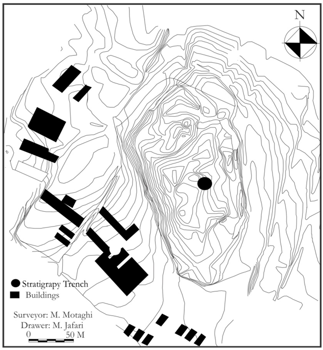 | Figure 3. Topography of Chenaran Site |
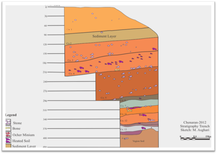 | Figure 4. Stratigraphy Section |
 | Figure 5. Local of Stratigraphy Trench |
4. Context 6
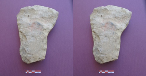
Context 6 was observed in the leading trench at a depth of -274 relative to the datum point. This context was under the context 5 and over the contexts 7, 8 and 9. Context deposits included clay, silt, clay heated with large amounts of ash, two pottery fragments with a thick, red cover and black motifs characteristic of Cheshmeh Ali pottery, as well as coal (Figure 6). Context 6 ended at a depth of -296m in the eastern wall. Cultural material in this context included two pieces of Lithics, one hoe, one core, a number of bladelet and Flake. 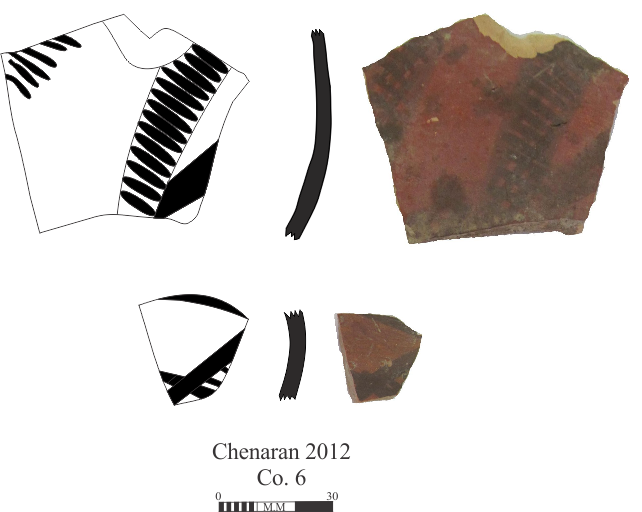 | Figure 6. Pottery of Context 6 |
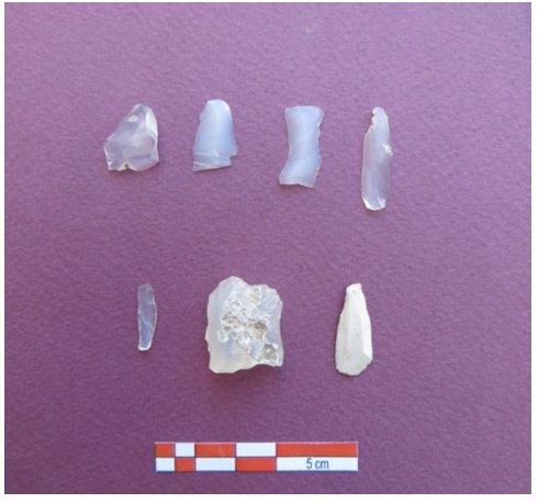
A total of 7 stone artefacts were collected from Context 6 including a thin blade core rock, 3 Bladelets with sickle gloss, 2 Flakes of chert with pale gray color and 1 Bladelet of creamy color (Figure 8). In addition to lithic, a Hoe was also found in this context (Figure 9). Several Fakes or their components which have not been used indicate that some Fakes were by products of Lithic, and were generated during the isolation process of core. A hoe found in the site and a number of Bladeless with sickle gloss in the edge indicate their use in cutting plant stems and the centrality of plants for livelihood of people in this site. These bladeless were combined using natural resins like tar in handles of bone or probably metal in later times, and were used as sickles to cut plants. Sickle gloss has been observed in lithic from neolithic period simultaneous with widespread use of plants by man, and parallel with the growing role of plants in human livelihood, it is increasingly observed in lithic.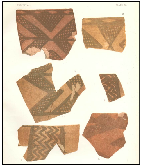 | Figure 7. Pottery of Cheshmeh Ali from Anau Tepe (Pumpelli 1904:pl.32) |
 | Figure 8. Lithics |
 | Figure 9. A hoe |
5. Cheshmeh Ali Culture and the Extent of its Sites in Khorasan
Pottery with red cover and geometric designs in black was first reported during Pumplley excavations in the lowest layers of the Anu Tepe (Anau Ia) located in the South West of Turkmenistan (Pumplley, 1904) (Figure 7). In 1912, de Morgan surveyed a Tepe in Rey, which was named Cheshmeh Ali due to its placement next to a fountain of the same name. Excavations were conducted by Eric Schmidt during three seasons in Cheshmeh Ali between 1934 and 1936. Schmidt divided the prehistoric traces of Cheshmeh Ali into two periods. The older was contemporary with Anau Tepe and the later period, which isitself divided into two sub-periods, coincided with Hissar Ia and Ib (Esfandiari, 1999). Geographical distribution of pottery series of Cheshmeh Ali encompasses large parts of north-central Iran, North East and South West of Turkmenistan. Cheshmeh Ali type pottery has different types: red covered with red texture and generally small bowl and pot forms in north-central Iran, buff texture and thin red coating in North East of Khorasan, and the type named Sialk II with Sialk I form by McCown identified in southwestern Turkmenistan and North of Khorasan. In general, Cheshmeh Ali pottery is a fine pottery with beautiful decorations and a red coat. The majority of pottery forms of Cheshmeh Ali are handmade, and potter's wheel has been gradually used at the end of the period. Fine sand forms the temper of fine pottery, and clay pottery has been thoroughly massaged. The pottery surface has thick clay glaze, and simple geometric motifs and animal and plant styles have been drawn in black on them. Animal design especially birds and horned animals are prominent among the designs of Cheshmeh Ali pottery (Talayi 2011, p 181). In addition to Sialk, Cheshmeh Ali and Zagheh sites, Cheshmeh Ali pottery has been found in many sites in the Central Plateau and Shahrood Sang Chaxmaq, Tureng Tepe (Ib), Yarim Tepe, Aq Tepe, Hotu and Belt sites in Gorgan. According to Malek, north central Iran has been the origin of Cheshmeh Ali culture, from where it has expanded to such areas as North East (Gorgan and Shahrood plains) and South West (Turkmenistan) (Shahmirzadi, 1999). During a survey of the upper valley of Atrak River, Ricciardi has introduced four settlements of Fath Abad, Khandagh, Jafar abad and an unnamed settlement (XA6) as settlements with similar finds with Anau I ( Ricciardi 1985, 1976 ). In 1998, Garazhyan identified Anau Ia type pottery in three sites of Yukhary Qaleh Qareh Goyonloo, Noroz Tepe and Yarim Tepe in Dargaz Plain adjoining the border with Iran and Turkmenistan (Garazhyan 1998). In 2002, Etemadi detected pottery types of Cheshmeh Ali in surface survey of Tepe Borj in Neyshabur Province. During the surveys in 2003 in North Khorasan Highlands, Cheshmeh Ali culture finds were identified in a Settlement named Zulpharah situated 114 kilometers south to Sabzevar on the eastern edge of the desert. In this study, Qaleh khan Settlement in Maneh and Samalghan district and Tepe Yam were detected with Cheshmeh Ali type pottery, with the former pottery being much similar to Cheshmeh Ali type pottery.
6. Conclusions
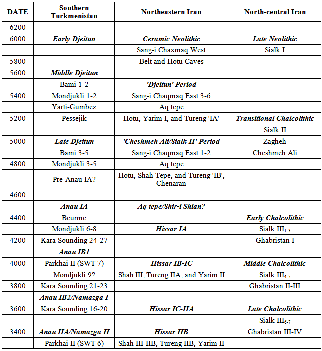
Due to the shortage of archeological studies in Khorasan and misunderstandings in this field, analysis of cultural material should rely on foothills of Turkmenistan, where the Prehistoric cultures are recognized with Jeitun culture in Neolithic period as well as Anau and Namazgah cultures in Chalcolithic period (Table 1). These names are derived from the hill names explored. Anau includes both northern and Southern hills, which are approximately located 12 km Southeast of Ashkh Abad (Kohl 1984: 18). Namazgah site is located about 154 kilometers southeast of Ashkh Abad, 90 km west of city of Tajan. As mentioned earlier, North East of Iran, especially Khorasan is called white in archaeological studies. In this study, we have dealt with Stratigraphic of one of the settlements named Chenaran, which is located in a plain between the mountains in northeast of Iran. Based on cultural materials especially pottery, Chalcolithic period has been suggested, which Coincides with Namazgah cultural period according to excavations conducted in Central Asia.Stratigraphic study of cultural material reveals homogeneity and specific relationship with neighboring areas. Based on pottery data, human communities of Chenaran settlement have had trans-regional relations with Central Asia and the Iranian plateau, and this in turn has caused their reciprocal effects, which is somewhat obvious, but a newer statistical community is required for better understanding. According to stratigraphy studies, 16 contexts have been detected in Chenaran settlement, which have been numbered from bottom to top. Relative Chronology suggested for these contexts is as follows:Anau Ia = Transition from Neolithic to Chalcolithic Namazgah I = Early Chalcolithic Namazgah II = Middle Chalcolithic Namazgah III = Late Chalcolithic Table 1. Chorological Table of Southern Turkmenistan, Northeastern Iran and North-central Iran
 |
| |
|
References
| [1] | Esfandiari, Azarmidokht, 1999. The status of Cheshmeali culture in the central plateau. Tehran: Institute of Archaeology. |
| [2] | Ghanbari, A., 2002. Geography of Chenaran city. First edition, Apadana Jam press. |
| [3] | Garazhyan, O. 1998. Archeological survey of prehistoric sites located in the border of Darungar River in North-East of Khorasan Province, thesis for MA in Archaeology, Tarbiat Modarres University. |
| [4] | Garazhyan, O and Rafi far, J. 2003. Research methods and practical bases for cultural relations during the transition period from the Neolithic to chalcolithic: Iran and Central Asia, to be published in Journal of Madras. |
| [5] | Hashemi Tabar, Z. 2009. Chenaran, Eleventh Annual Conference of the heads of History faculties in Khorasan Razavi Province. |
| [6] | Kohl, P.L., 1984: Central Asia: Paleolithic beginnings to the Iron age, Paris. |
| [7] | Majidi, N. et al, 2011. Determination of optimum cropping patterns consistent with management of water resources in Mashhad-Chenaran plain, Water and Soil journal, 25, 778-785. |
| [8] | Malek Shahmirzadi, S., 1999. Prehistoric Iran: Iran from the beginning to dawn of urbanization, Cultural Heritage Organization press. |
| [9] | Pumpelly, Raphaes, 1904. Explorations in Turkestan with an Account of the Basin of Eastern Perstern and Sistan, Washington: Carnegie Institution of Washington; 1905. |
| [10] | Ricciardi, Roberta Veone,"Greci, PartieSasanidi" (1985) In: neoQuarantelli, Ezio (ed.), La Terra tra i due fiumi: venti anni di archeologia italiana in Medio Oriente, la Mesopotamia dei tesori Torino: Quadrante, 1985, p. 289-293, 340-348. |
| [11] | Talayi, H., 2011. Eight thousand years of Iranian pottery. First edition, Samt press. |
 Abstract
 Reference
 Full-Text PDF
 Full-text HTML