-
Paper Information
- Previous Paper
- Paper Submission
-
Journal Information
- About This Journal
- Editorial Board
- Current Issue
- Archive
- Author Guidelines
- Contact Us
Archaeology
2013; 2(2): 23-27
doi:10.5923/j.archaeology.20130202.02
Re-theorisation of the Roads Heritage
 Abstract
 Reference
 Full-Text PDF
 Full-text HTML
Paola Villani
Dep. of Civil and Environmental Engineering, Transport Infrastructure and Geosciences, Politecnico di Milano, Milano, 20133, Italy
Correspondence to: Paola Villani, Dep. of Civil and Environmental Engineering, Transport Infrastructure and Geosciences, Politecnico di Milano, Milano, 20133, Italy.
| Email: |  |
Copyright © 2012 Scientific & Academic Publishing. All Rights Reserved.
Thanks to the opportunity of highway construction, a deep study has been conducted in order to understand the major influences that the Po Plain area had in the period 1800BC - 400 AD. Lack of basic ground items and a few but constant historical inconsistencies, have driven to a reconsideration of the commonly accepted and disclosed history. The analysis is based on a cross-reading of historical, artistic, literary preexistences, in a timeframe that concerns the period 1800 BC - 400 A.D. The paper gives a fresh look to the history of the area, from the evolution of Gallia Cisalpina, to the Galatians in Northern Italy and finally to Gens Cassia (previously named Elamites and Kassites) that introduced significant enhancements to the road technology and to transportation thanks to their deep knowledge in horse breeding, carriages construction and metalworks.
Keywords: Roads, Toll Roads, Toponyms, Transportation, Vehicles, Wheels, Wagons, Infrastructure, History, Religion, Language, Dialects, Europe, Asia, Pax Romana, Kassites, Trade, Toll
Cite this paper: Paola Villani, Re-theorisation of the Roads Heritage, Archaeology, Vol. 2 No. 2, 2013, pp. 23-27. doi: 10.5923/j.archaeology.20130202.02.
Article Outline
1. Introduction
- Cicero asserted "Alterius non sit qui suus esse potest" or "Let him not be another who can be himself"[1] and so identity of each groups transcend the centuries and leave its traces in history, from toponyms to heraldic symbols, from the perpetuation of traditions to language. In two papers[2,3] we have analyzed the data referring to the history roads, the place where according to the ancient kingdoms.The opportunity for the text drafting was the request to write the history of that across countryside involved in the construction of a new highway called BREBEMI (Brescia - Bergamo - Milano). In this paper has been used a "historical detective" methodology that cannot be described in a short paper. But like in a detective story, lack of basic ground items and a few but constant historical inconsistencies, have driven to a reconsideration of the commonly accepted and disclosed history. The analysis is based on a cross-reading of historical, artistic, ideogramic symbols and proto-writing, trade and other features of civilization, literary preexistences, in a timeframe that concerns since of the Intermediate Bronze Age up to 400 A.D.
2. History of the Area
- The area around Cassano d’Adda has always been crossed by many waterways – in ancient times, such waterways were necessary resources for watering animals and humans. So far, Egyptians have left an inscription which states: “A way without water is a no-way”. Such statement was considered valid in the whole world, regardless of latitude. The Appian Way used to be flanked by a waterway on which passengers were ferried at night and then could continue down the way on the road during the day. Boats used to be towed by mules.Pliny the Elder often refers to water supply points, which were vital places especially concerning Roman Legions displacements. Such places could even turn into real guard castrum or into border crossings points, which were often covered and walled spaces in order to host up to two thousand men. In ancient times, waterways were very important, since it was possible to transport goods and materials with little effort.Strabo, several times, mentions the transfer of men and goods using river boats and he is concerned to highlight the few rivers in which transport could be carried out only with extremely small boats.Now and then, the intermodal freight transport was important and while, on one side, it allowed goods to be carried effortlessly, on the other side it was, as today, an impedance factor for travel times: as a matter of fact, at that time, sea boats could easily sail up all the waterways, such as Adda and Oglio rivers, left-side tributary of the Po river in Lombardy and that did not happen - for example – with Nera, a tributary of the Tiber.Road tolls have not been invented by the Romans. At that time, travelling was a cost and as a matter of fact, a toll was much better and safer than an ambush. The risk was so high as to be often mentioned in declarations and invocations of the Bible with reference to the choice of the right way. Path had to be necessary safe, in order to be the right one. So far, to connect any location to another one, there were at least two different routes. Moreover, if the construction of a "public road" was certainly a source of income (because of the charged toll) to build roads was itself an affordable and assured prosperity to the village. The trade was taxed and constituted a source of considerable revenue. Exact sums in these toll stations were an important asset, and just a small portion was bound to what, nowadays, we classify under the name of "road management" (security, control and maintenance, or costs that resulted from the presence of post stations (mansio)).A well-established theory mentions that among the ancient civilizations, such one of Rome was the first and the only one to create and sustain a steady roads policy for nearly eight centuries, from 300 BC until the fall of the Western empire. We will see all, how often history is rewritten in retrospect by those ones who last held the power, and in terms of facts concerning "roads in history", such facts are not exactly the ones that have been handed down.Strabo reports the division of land over ancient times: Traspadana and Cisalpina. This part from Gallia Citeriore was also called Gallia Togata[Figure 1], after which we will explain the definition. Gallia Togata similarly reported as customary name in the text of Joannes Georgius Graevius.
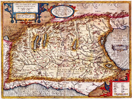 | Figure 1. Gallia Togata: Italia Gallica, sive Gallia Cisalpina |
3. Gallia Cisalpina
- First contacts between Rome and Verona are documented as early as the third century BC: it is told there were soon relations of friendship and alliance, but maybe it did not go exactly like that.Probably the first contacts were right in 390 BC, when Gauls of Brennus invaded Rome itself: historians have repeatedly asserted that the Venets realized the economic benefit of a possible peace treaty and had therefore put pressure on neighboring populations in order to ensure that Gauls came to terms with the Romans. These same historians have conveyed the story that Cenomani Gauls and Venets helped the Romans several times and even later, it is "fabricated news" but that will pass into history as erroneously the conquest of Cisalpina Gaul.The roman Senate required to Cenomani Gauls to expand the fortified castrum, which was on top of St. Peter's hill (Lessini Mountains), meanwhile they were busy with the foundation of a new city in the Adige bend. So far, it is obvious to see that, if you ask something to a population, it should mean that those ones were not at all subjected.History, the true one, tells something else: in 390 BC there was a battle in Allia (this may have given its name to the Gauls), such battle was fought near the small left affluent of the Tevere, and it was 11 miles far from Rome. In that area, 25-30 thousand men led by a chief (Brennus) defeated Roman army, which was hastily formed after it was ordered a levy en masse (tumultus) (July 18th, 390 BC). Romans capitulated and Gauls were thus able to enter Rome without resistance and putting it on fire. The siege ended only after the commitment made by the Romans to deliver one thousand pounds of gold, but the intervention of Camillo, persuaded Gauls to retreat, leaving much of the loot. It is clear that only an expert trading population could understand immediately how the sudden depletion of the other party couldn’t provide any economic benefit in medium - long term and this, just this, might have been the reason for the speech of Camillus to his compatriots Veliocassi so called "galli senoni". The well-known phrase[Non auro, sed ferro, recuperanda est patria] "not with gold but with iron you save your land! " made it possible to understand how the sale of large quantities of iron to the defeated Romans would bring lasting benefits to the community, who was settled at the confluence of Nera and Aniene. After this solution, Camillus, who was formerly part of ordo equester, was appointed commander of the Volscians, Aequi and Etruscans.In 49 BC, Caesar declared that Roman citizenship was being granted in Verona and the rank of municipium and agro of 3,700 km ² was being given by the Lex Roscia.At that time, tolls were widespread and transit was taxed in relation to the geographical location of the transporter: acquiring the Roman citizenship would have meant transporting and dealing in large part of Italy with a very low cost. Only in the capital, however, specific benefits were guaranteed for all dealers and thus, exempt from taxes and various tolls was assured. Everywhere, from Alps to Sicily, prices were different according to being or not being "Roman citizens".When referring to Gaul, thus we have to refer to Galati, who were descendants of the Celts who invaded Macedonia, led by "second Brennus"[literally, the second king]. Brennus invaded Greece in 281 BC and almost succeeded to reach the temple of Apollo at Delphi. Meanwhile, the Gauls killed the macedonian king Tolomeo Cerauno and afterwards they were rebuffed by Antigono Gonata, the grandson of Diodocus called Antigono I Monoftalmo. In 279 BC, other Gauls settled in Thrace and then, in 278 BC, they settled in Asia Minor. Nicomedes I of Bithynia had decided to seek help from the Gauls, in order to defeat his brother and therefore, three tribes (the Trocmi, the Tolistobogi e the Volci Tectosagi) moved far to Asia Minor. They were about 10,000 armed men, to whom to add an equal number of women and children.The new Celtic lineage colonists decided to settle permanently in the region (corresponding to the eastern Phrygia), which was known as "Galazia". Strabone described its state organization: according to the Celtic custom, each tribe was divided into "cantons" (as in Switzerland nowadays), and each one was governed by a chief (who was known as "tetrarca", such term was often used in Palestine), whose powers were almost unlimited, except for murder trials, during which the murderers were judged in a sacred place. Such place was known as Drynemeton (that is "temple of the oaks", those same oaks that have always been considered sacred in a vast area, from Asia Minor to the Brittany coast of France).It was the custom to go into the oak forests in order to swear by touching the wood of trees (Indo-Iranic treu). Such operation had to be repeated seven times. From this ancient custom comes the word troménie (tro-minihi, in Breton language, it literally means path (tro) of the minihi (sacred space)) from which the Latin word: monachium (monastery) derives. The pilgrimage of purging is still well-known today in the pre-Easter Christian custom, which is called "round of the seven parishes". Thus we may designate as "ancient places to consider as sacred," even all Indo-European toponyms which have the following prefixes sett*, sezz* o yed (in Azeri yeddi means seven) and from which derives the etymology of Jeddah (in Arabic, Ciddə), sacred city for Islam.If the original inhabitants of Phrygia had maintained political control of cities and lands, they were actually required to pay tithes to these "Galatians", who were sort of military aristocracy, living in fortified farms and separated by native (farms called "Qasim" from which then, "Cassim").These Galatians, otherwise known as Gauls or Cassi, were valiant warriors and highly respected by both the Greeks and Romans. They had knowledge of the use of metals and used it to manufacture wheels and helmets. Often they fought as mercenaries in the great battles of the time. For years, they had controlled the western part of Asia Minor and now and then, they were allies of this or that sovereign.
3.1. The Galatians in Northern Italy
- Regarding the land of northern Italy, historical informations have always been very deliberately confused: historians refers to the alleged culture of Golasecca and Villanoviana (proto-Etruscans) or to a vaguely defined "Bronze Age". For over a thousand years, until the advent of the Romans, trade and commerce, forge of helmets and gears took place on this country. Such business was spread all over an immense area, from the Atlantic to the Black Sea. A vase was found at Vix in Burgundy, finding dated 540 BC, and it shows the high quality achieved by Galatians craftsmen (Celts then). Furthermore, in this documentary evidence, wealthy life of this population is clear Such vase of Vix (named after the Latin, Vix crater, because in French, this term indicates all vases of clear Greek manufacturing) is a proven fact.In 540 BC, Carthaginians and Etruscans (united by common origin and language) drove out the Greeks from Corsica, while Rome was still under the total influence of the Etruscans: despite what is repeatedly mentioned by some Roman historians, it is quite impossible that the first kings of Rome were only seven, when considering the average age at that time and furthermore, the Urbe/City was ruled by various kings for about a quarter of a millennium (244 years).Few real historical facts, as mentioned, but then about these ones, it is necessary to proceed with the research.In 171 BC, a vast land, that stretched from the south of France and Illyria, was run by Cassio Longino, ancestor of the most famous one called Gaio Cassio Longino, who over a century later, took part to the murder of Caesar, but rather than murder, it was - probably - just an action to restore democracy in the world and to strike to death those who had unjustly robbed and killed.As Strabone asserts, Italy was inhabited by several tribes and they were united almost from a single ethnic group, since all of them were very little affected by administration and were devoted to a few and specific activities such as mining and metalworking, horse breeding, commerce. They were very cohesive and supportive to each other, shared a language (Semitic, considered of Phoenician strain). They were first ones to trace streets and to place milestones, furthermore they used to collect safe assets due to the tolls on transit. These early inhabitants, called by historians proto-Etruscans, took precautions - in a real self-defense system – in order that they could not be dispossessed by the Romans in any way, and thus, in order to protect those lands which belonged to them for generations, they had introduced ad hoc rules. Such rules were already included when drafting the "Law of the Twelve Tables" and as well, through them, for centuries, many taxes had not being paid, for example among them, those ones due to the norm of the right of burial. This perfectly explains the high number of busts and tombs along the Appian Way and other consular roads: from solemn tribute to the ancestors to a mere ploy to make an income for the coming centuries, and if necessary, transforming appropriate areas for graves in commerce places.The skill in breeding horses, which is still alive today thousands years later, in some specific areas of Italy (Tuscany, Cremona, etc..), such skill explains why there had always been a conspicuous presence of representatives of the ordo equester in the Roman Senate. Of course, each new war effort coming from Rome would push the gens Cassia (who provided both the means of transport - chariots and horses – and the manufacture of weapons) to significant and important assignments. Guaranteed revenues paid with public money. Just from the significant presence of many representatives of the ordo equester in the Senate, comes the name of Gallia Togata. Such name was used by old historians to define the northern Italy. But what was the origin of such population so devoted to extraction of metals and breeding of race horses ?
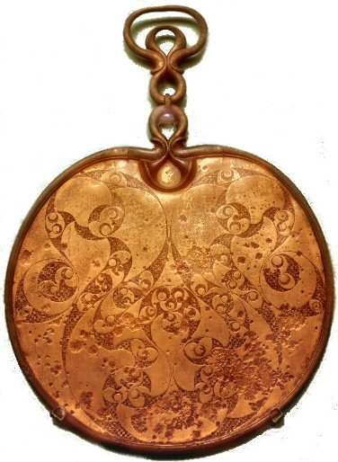 | Figure 2. The side of a bronze mirror from Desborough, Northants, England |
3.2. The Kassites
- The Kassites (people able to work the bronze with appropriate technology mainly as the ore cassiterite) were descents of Elam (offspring of Noah, Elam was the son of Sem and grandson of Cam and Iafet). Later on, they became known as Phoenicians (along the coast) and remained as Cassi inland. They developed among the Ittiti, Hurriti, Kassiti, Hyksos and they were all experts in breeding horses, in the construction of wagons and use of metals. They had knowledge of iron from 1600 BC and such iron, at the time, was more expensive than gold (five times more expensive) and silver (forty times less valuable than iron). The Kassites used to live in a mountainous and inaccessible areas and they knew how to use stones as noboby else ever did (excluding the Etruscans, who came directly from them). They were powerful military architects, builders of strategically insurmountable fortifications. Their cities were a model of architectural perfection, that was able to fit to the characteristics of the ground and that used all the possibilities of defenseSculptures and in general representations were of grand and solemn expression, either figures showing rulers or animals or other decorative items.
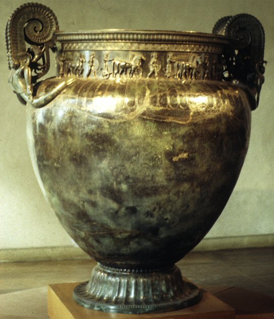 | Figure 3. The Vix Krate |
4. Conclusions
- History of cartography identifies with the history of men who have always tried to satisfy two of their basic needs: the safety of the place of residence and the desire to move and try to get food and resources. It follows that, at the same time, the map has always been a key tool in its broadest sense and, therefore, over time, some elements might have been purposely obscured. Strabone claimed that "description of the countries” had to respond to specific policy needs, to be intended in its full broadest sense: economic, military and strategic matters. No surprise therefore, whether with regard to our Peninsula, many historical information have been in time purposely obscured.