Meissam Aliei
PhD Candidate of Archaeology, Tarbiat Modarres University, Tehran, Iran
Correspondence to: Meissam Aliei, PhD Candidate of Archaeology, Tarbiat Modarres University, Tehran, Iran.
| Email: |  |
Copyright © 2012 Scientific & Academic Publishing. All Rights Reserved.
Abstract
After arrival of Islam in Iran, the number of monumental architecture including shrines and sepulchral places increased. Among the reasons for this phenomena immigration of offspring of Imams (Imamzadeh) and Sadat to Iran and their death or martyrdom in various places, and more over foundation of Shiite States in Iran could be mentioned. In general, this monumental architecture (sepulchral buildings) could be classified into two main groups: domed quadrangles and tomb like towers, among these two groups, domed polygonals take an intermediary state. Shemiranat region monuments in an area called Lavassanat and Roudbar Ghasran are typically domed polygonal in shape. Their histories, referring to various ages, mostly are dated to the Ilkhanid period. In this study we are to examine the general architectural features and embellishments of these buildings and their evolutionary process during history as well.
Keywords:
Architecture, Shemiranat, Lavassanat , Roudbar Ghasran, Sepulchral Buildings
Cite this paper: Meissam Aliei, Architectural Classification of Sepulchral Buildings from Saljuks to Qajar Period in Lavassanat and Roudbar Ghasran Region, Archaeology, Vol. 2 No. 2, 2013, pp. 15-22. doi: 10.5923/j.archaeology.20130202.01.
1. Introduction
Architecture is one of the important fields of art and civilizations which has been evolved during history till our days. During these times architecture, meeting human basic needs became an arena of various arts to demonstrate the glory and dignity of its owner. As in Iranian Islamic Architecture, Sepulchral monuments hold the second place among various monuments after the mosques[1]. This group of monuments can be surveyed and studied form different perspectives such as architectural, artistic, social, historical, cultural, and religious. In fact this kind of artworks has thrived Iranian Architecture during history. Each of mausoleums of this kind is an architectural museum[2].During history, Iranians always have special respect to their dead but this, before and after Islam, never means to worship them as gods or goddesses. This respect and regard can be interpreted as a synthesis of their theology and their fear of death, love, respect and care about their parents and ancestors which was never reached the stage of worshiping dead men. It must be mentioned that in contrary to some Muslim sects considering tomb and grave construction as polytheism, in Iran this phenomenon is a sign of respect and care about their ancestors and an endeavour in observation of their cultural and religious heritages and an attempt in maintaining a national identity[3].Considering these shrines and constructing these kinds of buildings are resulted from some reasons. The first is the belief in the world after death and the self- love and the next reason is the respect and regard of the fans and followers of the dead person. But one of the main reasons in constructing holy mausoleums (tombs of Imams and their Offspring)is the Shiite beliefs, which focal point is in Iran. As the mourning ceremonies of tenth of Muharram and its rituals became more evolved and complex, naturally more signs of reverence and bow was setup over graves.The growing rate of pilgrimage rituals of the graves of Imams and praying and reading Quran in these places, were the factors that resulted in construction of sepulchral monuments. The faith of the local people and permanent flooding of pilgrims coming from miles away would cause the development of holy shrines[4]
2. Geographical Location of the Region
Today Shemiran is divided into two parts: 1. A region located in the southern rang of central Alborz and now is connected to modern Tehran in the limits of municipalities of district 1 and parts of districts 2 and 4, which in historical texts is mentioned as Roudbar Ghasran (Tajrish).2) Districts and regions between valleys, and mountain peaks of the central Alborz and in the north and northeast of Tochal peak and the southern part of the central Alborz, with a decreasing height from west to east. This part is mentioned as interior (inner) Roudbar Ghasran in historical texts, which is divided into two parts: A) Lavassan: including small and large Lavassan. B) Roudbar Ghasran in the west of the region, geographical area of Roudbar e Ghasran is as follows[5].Furthest east of inner Roudbar Ghasran , is the origin of SiahPelas river, within the longitude of 51 degrees and 58 minutes and Ira’ village: at latitude of 35 degrees and 47 minutes and 56.2 seconds and at longitude of 51 minutes and 50 seconds and 27.8 seconds and height of 2427 meters above sea level and next to it(SirakSar pass) with geographical location of 35degrees and 48 minutes and 20.3 seconds latitude and 51 degrees and 49 minutes and 33 seconds longitude and height of 2341 meters above the sea level and its northeast area is SefidAb of Dasht e Lār (ĀbshārDovvom caravansary) with location of: 36 degrees and 1 minute and 37.6 seconds of latitude and 51 degrees and 48 minutes and 44.4 seconds of longitude and height of 3130 meters above sea level and its west is Shekarāb area with geographical location of 35 degrees and 55 minutes and 36.8 seconds latitude and 51 degrees and 25 minutes and 26.3 seconds of longitude and height of 2470 meters from sea level and its northwest is located in Dizin Pass with geographical location of 36 degree and 2 minutes and 14.5 seconds of latitude and 51 degree and 25 minutes and 58.6 seconds of longitude and height of 3300 meters from sea level. All over its southern frontage have been surrounded by the last southern mountain ranges of the central Alborz just like a huge wall stretching from Tochal peak (35 degrees, 53 minutes, and 03.5 seconds of latitude and 51 degrees, 25 minutes, and 11.6 seconds of longitude and height of 3992 meters from sea level) to SirakSar pass, neighbouring Ira’ village (east) (Map1)[6].The name of Ghasran is apparently an arabised form for Koohsarān or Koohsar Persian words meaning a hilly place/ highlands[7] and In the past, this region was used as a safe sanctuary and secure harbor during unsafe occasions, revolts and wars; and inhabitants of outer Roudbar Ghasran fluxed to this area from different parts such as Rey, Varāmin, Karaj, and Sāvojbolāgh when critical conditions occurred. It is because of the same reason that burial places of many offspring of Imams and eminent Shiites are located at this part. This feature which was similar to some regions including Alamout, Taleghan, Damavand, and Firouzkouh caused those sectarians who were tired of Omavid and Abbasid's injustice and tyranny to seek sanctuary at this place.
3. Investigated Sites
1) Imam Zadeh (offspring of Imam) Abdollah e Lavassan2) Imam Zadeh FazlAli e Nārān,3) Imam Zadeh Ibrahim e Ābnik,4) Imam Zadeh Tayyeb e Ābnik,5) Imam Zadeh Mousa Ābnik,6) Imam Zadeh Mohammad Bagher e Roudak,7) Imam Zadeh Mohammad Shoayb e Kond e Sofla,8) Imam Zadeh Seyed Khosro Nasser Abad,9) Imam Zadeh Mohammad and Abdollah e Boujan,10) Imam Zadeh Tayyeb e Rassanān,11) Imam Zadeh Fazl and Fazel e Chaharbagh,12) Imam Zadeh Khaje Soltan Ahmad Lavasan-e Bozorg,13) Imam Zadeh Younes Lavassan e Bozorg[8].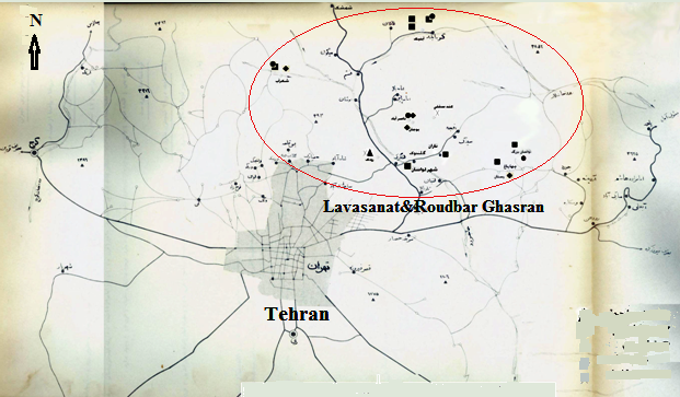 | Map 1. Map of region. (main illustration of Department of social sciences, university of Tehran,1968/69) |
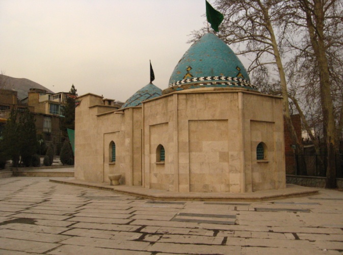 | Plate 1. Imam Zadeh Abdollah, Jaeij, Lavassan town |
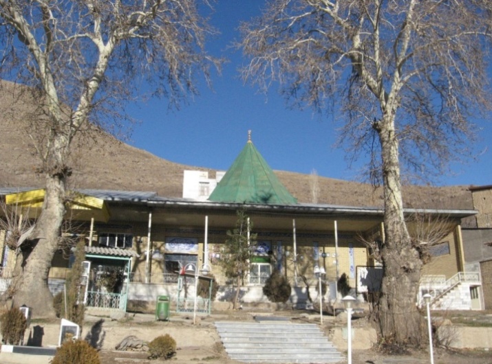
3.1. Imam Zadeh Abdollah Jaeij
(Lavasan town): geographical location: is located at 35 degrees, 49 minutes, and 7.14 seconds of latitude and at 51 degrees, 37 minutes and 44.0 seconds of longitude.(pl. 1)[9]
3.2. Imam Zadeh FazlAli e Nārān
(Lavassan town): is situated at 35 degrees, 49 minutes, and 35.4 seconds of latitude and 51 degrees, 39 minutes and 42.6 seconds of longitude (pl. 2).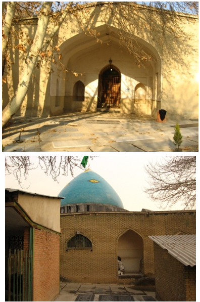 | Plate 2. Imamzade FazAli e Nārān, Lavassan town |
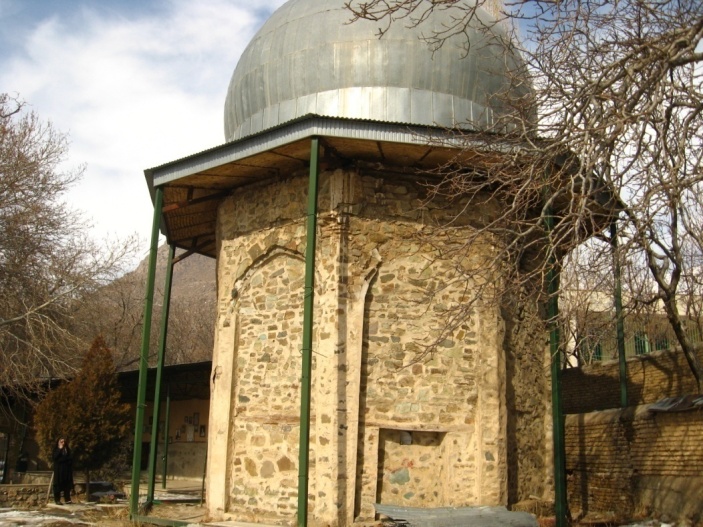
3.3. Imam Zadeh Ibrahim Ābnik
This offspring of Imam (Imamzadeh) is located at the northwest of Abnik village and in the western side of Kalaroud River and its geographical location is as follows: at latitude of 35 degrees, 59 minutes, and 22.9 seconds and longitude of 51degrees, 36 minutes and 7.59 seconds and height of 2450 meters above sea level. Imamzadeh is situated at the northwestern part of the village. The main materials of the building consist of rubble with stucco and clay mortar which are completely apparent from outside (pl. 3).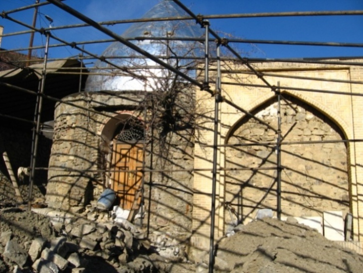 | Plate 3. Imamzade Ibrahim Abnik |
3.4. Imam Zadeh Tayyeb Ābnik
Its geographical location is: latitude of 35 degrees, 59 minutes and 16.1 seconds and longitude of 51 degrees, 36 minutes and 55.9 seconds (pl. 4).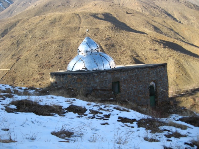 | Plate 4. Imamzade Tayyeb Abnik |
3.5. Imam Zadeh Mousa Ābnik
This shrine is located in Abnik village like Imam Zadeh Ibrahim and Tayyeb. This shrine is located in the southwest part and upper Imam Zadeh Tayyeb. Its geographical location is as follows: altitude of 35 degrees, 59 minutes, and 14.7 seconds and a longitude of 51 degrees, 36 minutes and 55.9 seconds (pl. 5).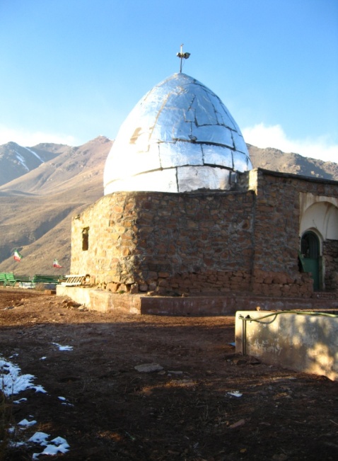 | Plate 5. Imamzade Mousa Abnik |
3.6. Imam Zadeh Mohammad Bagher e Roudak
This monument is situated on the southern end (upper part) of the village and in the western angle of Ziarat valley in geographical location of 35 degrees, 50 minutes, and 49.1 seconds of latitude and 51 degrees, 32 minutes and 51.8 seconds of longitude and at the height of 1869 meters above sea level. Apparently, the main materials of the building consist of rubble and traditional mortar of stucco. Today, all parts of the building including interior and exterior parts are covered with new materials (pl. 6). | Plate 6. Imamzade Mohammad Bagher Roudak |
3.7. Imam Zadeh Mohammad Shoeib Kond Sofla
Its geographical location is as follows: an latitude of 35 degrees, 51 minutes, and 52.9 seconds and longitude of 51 degrees, 38 minutes and 51.9 seconds and is situated on the height of 1992 meters from sea level. Materials of the building include rubble, stones from the bottom of the river and traditional stucco mortar (pl. 7). | Plate 7. Imamzade Mohammad Shoeib Kond e Sofla |
3.8. Imam Zadeh Seyed Khosro
Is located on about 1.5 km from northwest of Nasser Abad and in an area called Igeh. It is located in the eastern part of a valley, where the river flows. Its geographical location is: latitude of 35 degrees, 52 minutes and 42.9 seconds and a longitude of 51 degrees, 37 minutes and 50.4 seconds and height of 2096 meters above the sea level. Materials of the building consist of rubble and traditional stucco mortar (pl. 8).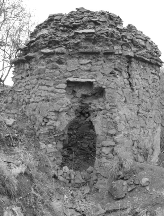 | Plate 8. Imamzade Khosro Nasser Abad |
3.9. Imam Zadeh Mohammad and Abdollah Boujan
Are located at the center of the village, south of the mosque and west of a road, running from Lavassan-e Kouchak (Lavasan town) to Boujan and Nasserabad. Its geographical location is as follows: 35 degrees, 51 minutes and 54.0 seconds of latitude and a longitude of 51 degrees, 37 minutes, and 23.1 seconds and on the height of 1985 meters from sea level. It seems that the main materials of the shrine have been originally consisted of stone and stucco mortar and during later periods it has been covered with bricks (pl. 9).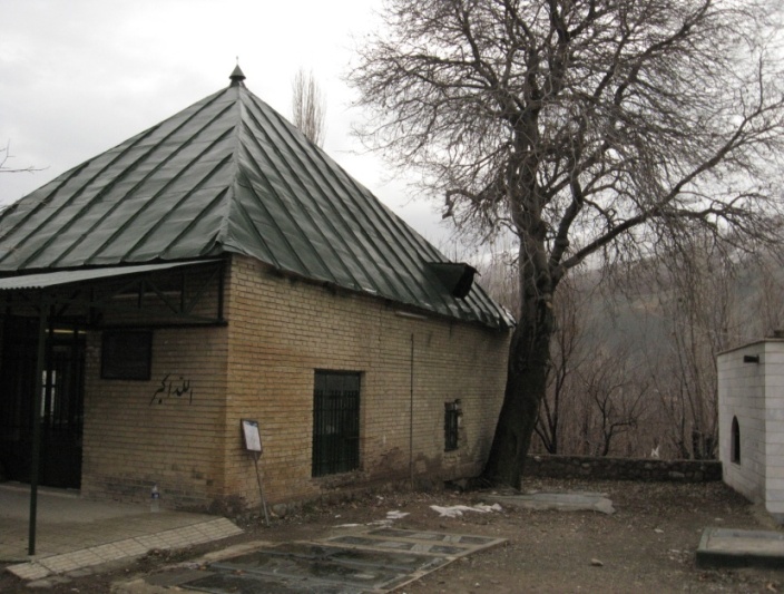 | Plate 9. Imamzade Mohammad and Abdollah Boujan |
3.10. Imam Zadeh Tayyeb e Rassanān
Is situated at the center of the village and besides a hill which is called Dezvareh hill by the indigenous people. On some graves existing beside the shrine, Dezvarei surname is observed. Its geographical location includes: an latitude of 35 degrees, 48 minutes, and 11.3 seconds and a longitude of 51 degrees, 45 minutes and 23.1 seconds and height of 1945 meters from the sea level. The main materials of the building include stone and mortar and materials of the joint building consist of brick and cement (pl. 10).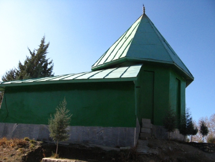 | Plate 10. Imamzade Tayyeb e Rassanān |
3.11. Imam Zadeh Fazl and Fazel Chahār Bāgh
The building is located in the southwest of the village and is practically situated out of the village's limits. The shrine is located on the right hand (east) of the main road. Its geographical location is as follows: latitude of 35 degrees, 48 minutes and 17.5 seconds and a longitude of 51 degrees, 45 minutes and 55.7 seconds and on the height of 1980 meters above the sea level. Materials of the main shrine (tower) include rubble and traditional stucco (pl. 11).
3.12. Imam Zadeh Khajeh Soltan Ahmad
Is located in northwest of the Lavassan e Bozorg village (Approximate to Lavassan town) and in Roudbar neighborhood, its geographical location is: latitude of 35 degrees, 49 minutes and 42.9 seconds and height of 2237 meters from the sea level. Major materials applied in constructing the shrine building include rubble and stucco (pl. 12).
3.13. Imam Zadeh Younes at Lavassan e Bozorg village
Its geographical location is as follows: latitude of 35 degrees, 49 minutes, and 24.6 seconds and latitude of 51 degrees, 47 minutes and 00.01 seconds and is situated on the height of 2188 meters above the seal level. The main materials employed in the building are stone and stucco (pl. 13). | Plate 11. Imamzade Fazl and Fazel e Chahar Bagh |
 | Plate 12. Imamzade Khajeh Soltan Ahmad |
 | Plate 13. Imamzade Younes |
4. Discussion
Based on statistical data, architectural features of these monuments Imam Zadehs (offspring of Imams) could be classified as following:According SPSS studies, materials are generally made of stone (rock). Entrances: the more the volume of the building is, the more the number of doors will be and on the other hand, the more the number of doors is, the more the number of lines is and in addition, the more the number of doors is, the more the type of prominence of the inscription is, the more contents are applied, the more recognizable the masters are, and the more clear the names of other people are.Relationship between dome and door: most of monuments with northern and eastern doors: have double vault domes but the monuments with doors on southern sides mostly have single- vault domes. The use of materials are the almost the same in each period. The higher the building is, the more the types of lines are and vice verse. This proportion for the height could be applied in the case of the contents (especially verses and Hadiths), names of the masters and other people as well.
5. Conclusions
Based on SPSS studies and Excel tables, all the buildings examined in present study are single, that means, in general they include the definition of "complex" of a number of graves belonging to different people that are situated in several adjoining buildings and constructions, which probably have distinct roofed graves (shrines) or boxes (such as Sheikh Safi el Din Ardebili complex or AbdolAzim-e Hassani holly shrine in Shahr-e Rey). Regardless this definition, with existence of incorporated (adjoint) rooms or prayer rooms (chapels) or graves existing in almost all important shrines (particularly religious ones), all of them are considered as complexes. Even some buildings like Imam Zadeh Mohammad and Abdollah e Boujan and or Fazl and Fazel Chahar Bagh have one grave stone, although the names of two individuals have been written on it. The basic material applied in all these buildings are stones of various types including river stones and rubbles. Although that in different periods (particularly, contemporary ages) decorations such as tiles or some basic materials like bricks have been applied them as well, but the main material is stones. Since the oldest monuments (like Imam Zadeh Mohammad Bagher Roudak) till the Ghajar period’s (such as Mohammad Shoeib Kond Sofla), although now in some buildings like Imam Zadeh Abdollah or Imam Zadeh FazlAli, we can see some different materials such as rubble and bricks but the main material in both of these monuments is stone, stucco and mortar. A mixture of stone (rock), stucco, and clay can be traces in constructing all these buildings. The cold weather and enough access to stone and various stone mines (due to mountainous climate of these regions)are the main logical reasons legitimate such materials in constructing these structures. While in southern Tehran in the region of Rey plain most buildings are made of bricks but in mountainous regions or the areas nearby there, in buildings such as Bibi ShahrBanoo shrine and NagharehKhaneh tower, having brick decorations are mostly made of stone materials.According their forms and plan these monuments could be divided into two general groups:1) Domed quadrangular/ square plan2) Domed polygonalBased on Hillenbrand's theory, the main difference between polygonal towers and domed polygonal is the ratio of their width to their height. As in rectangular towers, the width-height ratio is between 1 to 3.5 to 1 to 5.5. Lower than this proportion are considered as domed polygonals. Width-height ratio in Sultan Sanjar's shrine is: 1 over 2 and in Sultanieh dome is 1 over 2.2.[10].Ratios of width to height in the investigated rectangular buildings are as follows: 1) Imamzadeh Abdollah: 1 to 1.82) Imamzadeh Mohammad Bagher Roudak: 1 to 1.73) Imamzadeh Seyed Khosro: 1 to 1.54) Imamzadeh Tayeb Rasanan: 1 to 2.35) Imamzadeh Soltan Ahmad: 1 to 2.46) Imamzadeh Younes Lavassan-e Bozorg: 1 to 1.7Domed square shape buildings are as follows: 1) Imamzadeh Mousa Abnik: domed square shaped with beveled corners2) Imamzadeh Tayeb Abnik: domed square shaped with beveled corners 3) Mohammad Shoayb Kond Sofla: domed square.4) Mohammad and Abdollah Boujan: domed square.5) Imamzadeh FazlAli: has a Cross (cruciform/ Chalipai) form which is to some extent the same as domed square shaped.Among them, Imamzadeh Ibrahim Ābnik has an interior square shape but a circular outer plane. Despite its circular shape and the dome above it, it must have been naturally named as tower; but, its width-height ratio is approximately 1 to 1. Imamzadeh Fazl and Fazel Chahar bagh are also round shaped and its width-height ratio is 1 to 1.5. Although two latter buildings are circular in shape, their width-height ratio is less than the minimum value of 1 to 3.5 which has been considered as a criterion by Hillenbrand.Regarding the concept of “tower” that brings in mind the highness and public visibility but as these two monuments are not tall enough we can place them within sub-groups of domed polygonal tombs and the term (expression) "domed circular" tombs could be applied for them. However, in some western regions of Iran, a house inside the garden is called "tower"; nevertheless, as mentioned previously, the term tower here means height and visibility from far distance. Among the investigated buildings except two cases, Imamzadeh Tayeb and Imamzadeh Seyed Khosro, all have graveyards around them. Imamzadeh Tayeb is located lower than Imamzadeh Mousa and is situated on the mountain slope which is not suitable for burial, although Imamzadeh, itself, has been buried at the very same part of the mountain. However, recently beside Imamzadeh Mousa Abnik which is located upper than Imamzadeh Tayeb, several martyrs have been buried. Otherwise, this Imamzadeh lacks other burials around it too. Practically, no grave is seen around the building of Imamzadeh Seyed Khosro too; and it is only surrounded by gardens and trees. Even no trace of grave or burial sites can be observed inside the shrine, which is known as "Imamzadeh" Seyed Khosro. There are some newly constructed mosques or Hosseinieh(s) around Imamzade Abdollah and Fazlali and Imamzadeh Ahmad.From among the investigated buildings: 1) Imamzadeh Mohammad bagher Roudak: apparently belongs to Saljuq period. 2) Imamzadeh Abdollah, Fazl’ali, Tayyeb e Abnik, Mousa Abnik, Tayyeb e Rasanan, and Ahmad Lavasan-e Bozorg: are related to the 7 & 8/ 13&14 century i.e. Ilkhanid period.3) Imamzadeh Ibrahim Abnik belongs to Ilkhanid-Timurid period (8&9/ 14&15 century) and Imamzadeh Younes Lavassan e Bozorg is related to Timurid period. 4) Imamzadeh Seyyed Khosro is related to the 9th and 10th century (Ilkhanid-Timurid), Mohammad and Abdollah e Boujan and Fazl and Fazel belong to Safavid period. 5) Imamzadeh Mohammad Shoayb Kond e Sofla is also related to Qajar period. Most of these buildings are dated to Ilkhanid period (a little more than 45percent) and some shrines such as Emamzadeh Fazlali and Mohammad Bagher e Roudak have been reconstructed in Qajar period. All the investigated buildings are religious and namely called "Imamzadeh". Even the monument attributed to Seyed Khosro, although lacks any burial, is associated with "Imamzadeh” prefix as well as structures known as Shahcherāgh and PirJabbār shrine, both in Garmābdar village near Fasham, despite having found a shrine state, lack any kind of burial traces or grave stone.Most of these buildings belong to Ilkhanid period. Kings such as Sultan Mohammad Khodabandeh (Oljayto) during Mongolian Ilkhanans have had extreme Shiite sect tendencies, so the probability that these kinds of buildings had been more prevalent during that section is high. At this period, sepulchral complexes were increased. Despite this fact, since Alavid and some dynasties such as Mar’ashid of Mazandaran and Al-e Kia in Gilan and Al-e Buyids in Rey districts were Shiite (sectarian) and the regions investigated in the present study have been more under dominion of these dynasties, it is more probable that sepulchral buildings had been constructed and developed more than other regions. Nevertheless, most Iranian religious shrines, which are called Imamzadeh and some names of this type, are located at the mountainous areas of the northern central plateau and west of Iran, which was the commuting path of the Islamic caliphate centre to Khorassan and eastern areas. The significant point is the role of authorities or namely custodians in continuing and prospering of these buildings beside the governments' role. Apart from the investigated buildings, which are most related to Ilkhanid period, after Safavid period and when Shiite religion became official, naturally the prosperity of religious buildings, especially Imamzades were increased. Apparently, a person who had the responsibility of taking care of each shrine transferred the same duty to the next generation and therefore this responsibility has been continued in their families. For example, on the wooden transenna related to Timurid period in Imamzadeh Younes Lavasan-e Bozorg, the name of "Shahāb" has been carved. Also, today custodianship and reserving this shrine is held by "ShahābLavāssāni"' family. As attested by girl of the late ShahābLavāssāni, the name of "Shahāb" belonged to the ancestor of this family and at the present time this name is used as their middle name.Almost all the investigated buildings do not have special and old embellishments inside them. The only noticeable (with negligence) examples are squinchs under domes (like Imamzadeh Mohammad and Abdollah Boujan). In the old mosque next to Khajeh Soltan Ahmad in Lavassan-e Bozorg village, a number of drawings (Rasmibandi) and Yazdbandi can be observed. A number of blind arcades can be seen in outside of Imamzadeh Tayeb Rassanan, Sultan Ahmad of Lavasan-e Bozorg, and Imamzadeh Younes of Lavasan-e Bozorg. Other embellishments of these buildings belong to later (recent) times and are mostly in the form of mirror-encrusted stalactite and are applied in inner parts like: Imamzadeh Abdollah e Jaeij, Fazl’ali e Nārān, Tayyeb e rassanan, Fazl and Fazel e Chaharbagh, and Khaje Sultan Ahmad.Some examples of new masonry (brickwork) are observable in Imamzadeh Fazlali, Ibrahim Abnik, and Imamzadeh Younes of Lavasan-e Bozorg. Among the investigated buildings, there are some old boxes or transennas. One exists in the shrine of Imamzadeh Fazlali dated 951 A.H., another in Imamzadeh Tayeb Rasanan dated 847 A.H., and the third case is in Imamzadeh Khajeh Sultan Ahmad of Lavasan-e Bozorg dated 937 and 935 A.H., and finally the forth one exists in Imamzadeh Younes with the date of 887 A.H. However, shrine of Imamzadeh Fazl and Fazel Chaharbagh also has the date of 1316 which is not clear whether it is Solar or lunar year. According to the mentioned dates, two transennas are related to Timurid period and two belong to Safavid. Finally, the fifth one at most relates to Qajar periods. Two boxes of Safavid period belong to the first Shah Tahmasseb's Era. Since the body of Seyyed Hamzeh – the ancestor of Safavid kings- had been buried in holly shine of the Excellency AbdolAzim e Hassani, it was in this period when more attention was given to Shahr-e Rey, Tehran and their suburbs; so that the oldest tile makings of Imamzadeh Hadi in Shahr-e Rey have been done during this king's period[11]; and a fortification was established around Tehran upon his order. At the same time his name can be seen on the transenna of Imamzadeh FazlAli of Lavasan and also in the old mosque located in Lavasan-e Bozorg village which denotes a linking between north and south of Tehran (Rey and Ghasran) districts during past ages.
ACKNOWLEDGEMENTS
This paper is dedicated, with gratitude; to my Late master Dr. Farhang Khademi Nadooshan (1960 – 2012). May God bless his soul.
References
| [1] | Hillenbrand, Robert (2004), Islamic Architecture. Trans Bagher Ayatullahzade Shirazi. 2nd print. Tehran: Rowzaneh Publications. P. 272 |
| [2] | Pirnia. Mohammad karim. (2008). Iranian Architecture. Compiled by Gholamhossein Me’marian. Tehran: Sorush e Danesh Pub. P 312. |
| [3] | Gharvi. Mehdi (1997). Mausoleum in the scope of Persian culture. 1st print. Tehran: Society for the Appreciation of Cultural works and Dignitaries. P.14,15. |
| [4] | Hillenbrand, Robert. (2007). The tombs. Trans by Keramatollah Afsar. In Iranian Architecture (Islamic Period). Compiled by M.Y. Kiani. 5th Pr. Tehran: SAMT Pub. P. 60 – 62 |
| [5] | Mahmoudian, Aliakbar., et.al., 2002, Atlas of Shemiran county, Tehran, Institute of Geography, Cartography, and Cosmology. |
| [6] | Atlas of Tehran: Civic equipment and leisure time at Tehran, 1968-69, Tehran, social studying Institute of Department of social sciences, University of Tehran. |
| [7] | Kariman, Hossein. (1977), Ghasrān, vol.1. Tehran: Society for National Works publications. P.75. |
| [8] | Data applied here about offspring of imams, Seyed Taher and Zahed, and Pir-e shekar Āb and some geographical informations have been taken from following references: -Pazouki, Nasser. (2002), Report of survey and recognition of historic- cultural monuments at governorship area of Shemiranat. Tehran: Research Institute to the cultural Heritage. -Idem, (2003), Historic Sites of Shemiran, Vol. 1 , first edition, Tehran: cultural Heritage Organization of Tehran province. |
| [9] | All the Plates are taken by the author. |
| [10] | for detailed explanations, see Hillenbrand, Robert. (2004), Islamic Architecture,: Form, Function, and Meaning (Section of tomb), Columbia University Press. |
| [11] | Barzegar, Ali., (2001), A Survey of Shrines of Islamic Period at Shahr-e Rey, M.A. Thesis in Archeology, Tehran, Faculty of Humanities of Tarbiat Modarres University, p.275. |
 Abstract
 Reference
 Full-Text PDF
 Full-text HTML