
-
Paper Information
- Paper Submission
-
Journal Information
- About This Journal
- Editorial Board
- Current Issue
- Archive
- Author Guidelines
- Contact Us
Architecture Research
p-ISSN: 2168-507X e-ISSN: 2168-5088
2026; 16(1): 21-35
doi:10.5923/j.arch.20261601.02
Received: Jul. 10, 2026; Accepted: Jul. 25, 2026; Published: Jul. 30, 2026

Flood Risk Readiness and Architectural Mitigation Strategies for Religious Premises: A Case Study of Luhanga Catholic Church, Dar es Salaam, Tanzania
 Abstract
 Reference
 Full-Text PDF
 Full-text HTML
Henry M. Rimisho
Ardhi University (ARU), P.O. Box 35176, Dar es Salaam, United Republic of Tanzania
Correspondence to: Henry M. Rimisho, Ardhi University (ARU), P.O. Box 35176, Dar es Salaam, United Republic of Tanzania.
| Email: |  |
Copyright © 2026 The Author(s). Published by Scientific & Academic Publishing.
This work is licensed under the Creative Commons Attribution International License (CC BY).
http://creativecommons.org/licenses/by/4.0/

Flooding has become one of the most critical urban environmental hazards affecting rapidly growing cities across the Global South. In Dar es Salaam, Tanzania, accelerated urbanization, inadequate stormwater infrastructure, informal settlement expansion, and climate variability have significantly increased flood exposure, particularly within low-lying institutional and residential areas. Despite extensive research on urban flooding, limited attention has been given to the preparedness of religious premises, which function as places of worship, community service centres, and emergency gathering spaces during disasters. This study assessed flood risk readiness and architectural mitigation strategies at Luhanga Catholic Church in Mabibo Ward, Kinondoni Municipality, Dar es Salaam. A mixed-methods case study approach was adopted, combining field observations, semi-structured interviews, questionnaire surveys, photographic documentation, and document review. Qualitative data were analysed using thematic analysis, while descriptive statistics were used to summarise questionnaire responses. The findings indicate that flood vulnerability is primarily associated with the overflow of adjacent stormwater channels, uncontrolled surface runoff from surrounding high-density neighbourhoods, inadequate on-site drainage infrastructure, and unplanned urban development. Existing mitigation practices were found to be largely reactive, fragmented, and insufficient to cope with increasing flood frequency and intensity. The study further identifies architectural and planning interventions including improved drainage networks, rainwater harvesting systems, landscape-based stormwater management, flood-resilient building design, and coordinated land-use planning as practical measures for enhancing institutional flood resilience. The study contributes to the growing body of disaster risk reduction and urban resilience literature by positioning religious premises as critical but under-researched components of urban resilience systems. The findings provide evidence-based recommendations for architects, planners, engineers, faith-based organisations, and local authorities seeking to strengthen flood preparedness and climate adaptation within institutional environments in rapidly urbanising African cities.
Keywords: Flood risk readiness, Architectural mitigation, Religious premises, Urban resilience, Stormwater management, Climate adaptation, Dar es Salaam
Cite this paper: Henry M. Rimisho, Flood Risk Readiness and Architectural Mitigation Strategies for Religious Premises: A Case Study of Luhanga Catholic Church, Dar es Salaam, Tanzania, Architecture Research, Vol. 16 No. 1, 2026, pp. 21-35. doi: 10.5923/j.arch.20261601.02.
Article Outline
1. Introduction
- Flooding has become one of the most frequent and destructive natural hazards affecting urban environments worldwide, particularly in rapidly growing cities of the Global South. Increasing climate variability, extreme rainfall events, unplanned urbanization, and inadequate stormwater infrastructure have significantly intensified flood risks, resulting in substantial social, economic, and environmental losses [13]; [35]. Beyond damaging physical infrastructure, urban flooding disrupts public services, threatens human safety, and undermines the resilience of communities and institutions.In Sub-Saharan Africa, many cities are experiencing rapid urban expansion that exceeds the capacity of existing infrastructure and spatial planning systems [1]; [2]. Dar es Salaam, Tanzania's commercial capital and largest metropolitan area, exemplifies these challenges. The city has witnessed rapid population growth, informal settlement expansion [18], encroachment into wetlands, and increasing impervious surfaces, all of which contribute to recurrent flooding during seasonal rainfall events [15]. Previous studies have consistently identified inadequate drainage networks, uncontrolled surface runoff, poor land-use management, and settlement development along floodplains as major contributors to urban flood vulnerability [6]; [7]; [36].Although extensive research has examined flood risk in residential neighbourhoods, informal settlements, and transportation infrastructure, comparatively little attention has been given to religious premises as critical components of urban disaster risk management. Churches, mosques, and other faith-based institutions perform multiple functions beyond religious worship. They frequently serve as community centres, emergency shelters, relief distribution points, and locations for social support during and after disasters [9]; [16]. Consequently, their operational continuity and physical resilience are essential for effective disaster preparedness and community recovery. Despite these important roles, architectural and planning strategies for improving flood resilience [2] within religious premises remain insufficiently documented, particularly in rapidly urbanising African cities.Luhanga Catholic Church, located in Mabibo Ward of Kinondoni Municipality, Dar es Salaam, provides an appropriate case study for investigating institutional flood resilience. The church compound occupies approximately two hectares and comprises the main church building, parish offices, Sisters' residences, and a hostel facility. Situated approximately 8 km northwest of the city centre, the premises lie within a low-lying urban catchment bordered by dense residential neighbourhoods and industrial developments. The site is exposed to recurrent flooding resulting from overflow of adjacent stormwater channels, uncontrolled surface runoff from surrounding settlements, and inadequate drainage infrastructure.Against this background, the present study assesses the level of flood risk [25] readiness and evaluates architectural and planning-based mitigation strategies applicable to religious premises. Specifically, the study examines the principal sources of flood vulnerability, evaluates existing preparedness measures [19], and proposes integrated architectural, landscape, and urban planning interventions that can enhance institutional resilience [33]. By focusing on a religious institution, the study contributes to the growing body of knowledge on disaster risk reduction by extending flood resilience research beyond conventional residential and commercial settings. The findings provide practical guidance for architects, planners, engineers, local authorities, and faith-based organisations seeking to strengthen climate adaptation and disaster preparedness within institutional environments.
2. Literature Review
2.1. Urban Flood Risk and Climate Vulnerability in Rapidly Growing Cities
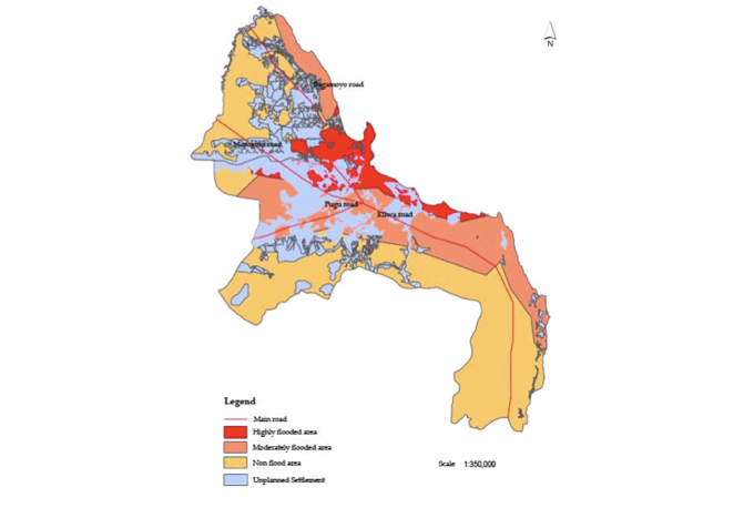
- Flooding has become one of the most critical urban environmental challenges facing cities worldwide, particularly in rapidly urbanizing regions of the Global South [34]; [21]. Increasing climate variability, intensified rainfall events, uncontrolled urban expansion, and inadequate infrastructure systems have significantly increased urban exposure to flood hazards [27]. The Intergovernmental Panel on Climate Change [13] identifies urban areas as highly vulnerable systems where climate-related risks interact with social, economic, and physical vulnerabilities [5].Unlike natural floodplains where periodic flooding may occur as part of ecological processes, urban flooding is frequently intensified by human activities, including land-use transformation, expansion of impervious surfaces, encroachment into drainage corridors, and inadequate stormwater management systems. Urban development modifies natural hydrological processes by reducing infiltration capacity and increasing surface runoff volumes, thereby placing additional pressure on drainage infrastructure [7]; [11].In developing cities, flood risks are further intensified by rapid population growth and informal settlement expansion [25]; [26]. Many urban areas grow faster than planning and infrastructure systems can accommodate, resulting in settlements located in environmentally sensitive areas such as wetlands, river valleys, and low-lying flood corridors [35]; [37]. These challenges demonstrate that flooding is not only a natural hazard but also a consequence of planning decisions, governance limitations, and infrastructure deficiencies.Dar es Salaam represents such a rapidly transforming urban environment. The city has experienced extensive spatial expansion driven by population growth, economic activities, and migration [31]; [34]. However, infrastructure development, particularly stormwater management systems, has not expanded at the same pace. Consequently, many residential and institutional developments are increasingly exposed to flood risks associated with intense rainfall events and inadequate drainage capacity [18].Therefore, understanding urban flood vulnerability requires an integrated perspective that considers environmental processes, physical structures, land-use patterns, and institutional capacity. This study adopts this perspective by examining how these interacting factors influence flood readiness within Luhanga Catholic Church premises.
2.2. Urban Flood Resilience and Disaster Risk Reduction Frameworks
- Contemporary approaches to flood management have increasingly shifted from conventional flood protection strategies toward resilience-based approaches [38]. Earlier approaches focused primarily on controlling water through engineered infrastructure such as drainage channels, flood barriers, and embankments. However, increasing uncertainty associated with climate change has demonstrated that complete prevention of flooding is often unrealistic. Instead, resilient urban systems aim to anticipate, absorb, adapt, and recover from flood events [21].Urban resilience refers to the capacity of urban systems, including buildings, infrastructure, institutions, and communities, to maintain essential functions while adapting to changing environmental conditions. According to [38], effective resilience requires integration between physical interventions, governance mechanisms, and community participation.The disaster risk reduction framework promoted by the United Nations Office for Disaster Risk Reduction [31]; [35] emphasizes that disaster impacts result from the interaction between hazards, exposure, and vulnerability. Therefore, reducing flood impacts requires not only controlling floodwaters but also reducing exposure through appropriate planning, resilient design, and institutional preparedness.Within this framework, buildings and institutional facilities are increasingly recognized as important components of urban resilience systems. Schools, hospitals, and religious facilities often serve broader social functions beyond their primary purpose. Their resilience therefore contributes not only to asset protection but also to community continuity during emergencies.Applying resilience theory to religious premises provides an opportunity to examine how architectural design, site planning, and institutional preparedness can reduce vulnerability. This study contributes to this discussion by assessing flood readiness within a religious institution that functions simultaneously as a worship facility, social space, and potential emergency support location.
2.3. Flood Vulnerability in African Cities and the Dar es Salaam Context
- African cities face distinctive flood challenges resulting from rapid urbanization, limited infrastructure investment, informal development patterns, and institutional capacity constraints [36]. Unlike many developed cities where flood management systems are supported by extensive infrastructure networks, many African urban areas experience increasing flood exposure due to inadequate drainage systems and uncontrolled settlement growth [20].Urban expansion in many African cities occurs through informal processes where development frequently precedes infrastructure provision [20]. Consequently, settlements may occupy flood-prone locations without adequate drainage, road networks, or environmental management systems. These conditions increase both the frequency and severity of urban flooding.Dar es Salaam provides a significant example of these challenges. The city’s rapid expansion has transformed previously natural drainage areas into densely occupied urban spaces. Flooding has become a recurring challenge affecting residential areas, transport infrastructure, public facilities, and community institutions.Studies on Dar es Salaam indicate that land-use transformation, inadequate stormwater systems, and occupation of environmentally sensitive areas contribute significantly to flood vulnerability [18]. The city’s flood challenges are therefore associated not only with rainfall intensity but also with spatial planning deficiencies an ßd infrastructure limitations.While considerable research has examined residential vulnerability and urban drainage challenges, limited attention has been given to institutional land uses, particularly religious premises. This represents an important research gap because such facilities occupy strategic locations within communities and often serve vulnerable populations during emergencies.
2.4. Religious Premises as Social Infrastructure and Disaster Resilience Nodes
- Religious institutions represent important forms of social infrastructure within urban communities. Beyond their spiritual functions, churches, mosques, and other religious facilities frequently provide spaces for education, social support, humanitarian assistance, and community mobilization.During disasters, religious premises may become temporary gathering spaces, communication centres, or locations for humanitarian support. Their accessibility, community trust, and physical presence make them important components of local resilience systems.However, despite this social significance, religious buildings have received limited attention within urban disaster risk research. Existing flood resilience studies have concentrated mainly on residential areas, transportation infrastructure, and critical public facilities such as hospitals and schools. Institutional religious spaces remain comparatively under-investigated.From an architectural perspective, religious premises require specific consideration because their spatial organization, building forms, landscape conditions, and circulation patterns influence their ability to withstand flood events. Flooding may disrupt worship activities, damage valuable property, restrict accessibility, and compromise their ability to support communities during emergencies.Therefore, assessing flood readiness of religious premises requires an integrated approach combining:• site analysis,• architectural assessment,• drainage evaluation,• landscape management,• community preparedness.This study addresses this knowledge gap by investigating Luhanga Catholic Church as an example of a religious institution exposed to urban flood risks in Dar es Salaam.
2.5. Architectural and Nature-Based Flood Mitigation Strategies
- Flood resilience requires a combination of structural, architectural, and ecological strategies. Structural approaches include drainage improvement, flood barriers, riverbank protection, and channel expansion. These interventions remain essential where flood exposure is high and existing infrastructure capacity is insufficient.However, contemporary flood management increasingly emphasizes integrated approaches combining engineering solutions with ecological systems. Nature-based solutions such as vegetation restoration, permeable surfaces, rainwater harvesting, and landscape management can reduce runoff generation while improving environmental sustainability [15].At the building scale, architectural adaptation strategies include:• elevated floor levels,• flood-resistant materials,• protected entrances,• suspended structures,• improved drainage connections.Such approaches allow buildings to coexist with changing hydrological conditions rather than attempting complete exclusion of water from urban environments.Stormwater management strategies such as Sustainable Urban Drainage Systems (SuDS) also provide opportunities for reducing flood impacts through improved infiltration, detention, and controlled water movement [8].For institutional premises located within flood-prone environments, successful mitigation requires coordination between architects, engineers, urban planners, local authorities, and community stakeholders. Therefore, flood resilience should be understood as an integrated architectural and urban planning challenge rather than a purely engineering problem.This study applies this integrated perspective by examining how architectural interventions, drainage improvements, and landscape strategies can enhance flood readiness at Luhanga Catholic Church.
2.6. Research Gap and Contribution of the Study
- Although existing literature provides extensive knowledge on urban flooding and climate adaptation, three important gaps remain.First, limited studies have examined flood vulnerability of religious premises as institutional resilience spaces [12].Second, much of the existing flood research in African cities focuses on residential settlements, with less attention given to community institutions that support urban resilience.Third, insufficient attention has been given to architectural strategies that combine site planning, drainage management, and building adaptation within flood-prone institutional environments [14].Therefore, this research contributes by providing empirical evidence from Luhanga Catholic Church, Dar es Salaam, demonstrating how religious premises can be assessed and strengthened as resilient urban infrastructure.
3. Results
3.1. Study Area Characteristics
- Luhanga Catholic Church occupies approximately 2 hectares within Mabibo Ward, Kinondoni Municipality, Dar es Salaam. The church compound comprises the main church building, parish offices, Sisters' residences, and a hostel facility. The premises are located approximately 8 km northwest of Dar es Salaam city centre and are accessible via Kigogo Road, which connects the area to the central business district and the Ubungo transport terminal.The surrounding environment is characterised by high-density residential neighbourhoods and industrial developments, reflecting the rapid urbanisation of Mabibo. While these location advantages have encouraged socioeconomic development, they have also increased the exposure of the church premises to recurrent flooding. The site's location within a low-lying urban catchment, combined with inadequate stormwater infrastructure and uncontrolled urban expansion, has significantly increased its flood vulnerability.
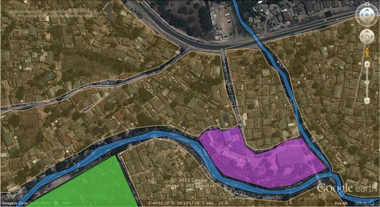 | Image 3.1. The Location and surrounding land uses of Luhanga Catholic Church, Mabibo Ward, Dar es Salaam. Source: Adapted from Google Maps (2025) |
3.2. Major Sources of Flood Risk
- Field observations, interviews, and document analysis identified four principal factors contributing to flood risk at Luhanga Catholic Church.
3.2.1. Overflow of Adjacent Stormwater Channels
- The church compound is situated between two stormwater drainage channels. The principal channel conveys runoff from upstream catchments, including Mbezi, Kimara, and Kigogo, before discharging into the Indian Ocean through the Jangwani floodplain. During periods of intense rainfall, the existing channel capacity becomes insufficient, resulting in overtopping of the riverbanks and inundation of the church premises.The secondary drainage channel located east of the site further contributes to flooding by conveying runoff from surrounding neighbourhoods into the main drainage system.
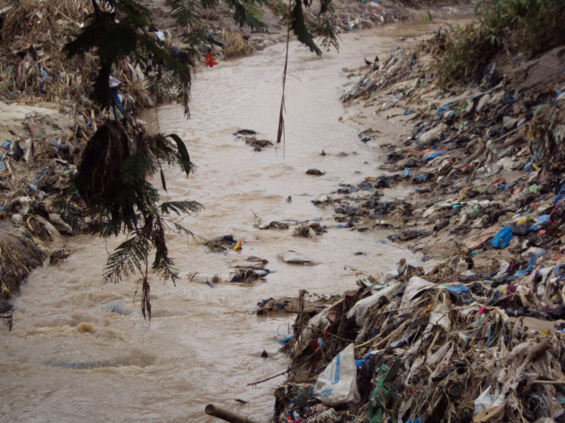 | Image 3.2. Major and minor stormwater channels surrounding Luhanga Catholic Church. Source: Figures adapted from Google Maps (2025) and field survey (2025) |
3.2.2. Uncontrolled Surface Runoff
- Rapid urbanisation surrounding the church has substantially increased impervious surfaces, including buildings, roads, parking areas, and industrial compounds. Consequently, rainfall infiltration has declined while surface runoff has increased considerably.Because the church premises occupy one of the lowest elevations within the neighbourhood, stormwater generated from surrounding residential and industrial developments naturally converges toward the site, thereby increasing flood frequency and intensity.
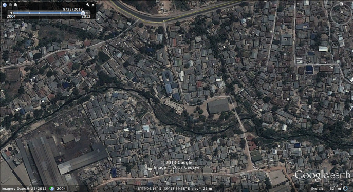 | Image 3.3. Uncontrolled surface runoff from unplanned neighborhood flows toward the site. Source: Adapted from (Google Map, 2025) |
 | Image 3.4. High-density urban Adapted from Google Maps (2025). Source: Adapted from Google Maps (2025) |
3.2.3. Inadequate On-Site Drainage Infrastructure
- Field assessment revealed that the existing drainage system within the church compound is inadequate to accommodate peak stormwater flows. Drainage channels are limited in both capacity and spatial coverage, resulting in ponding and prolonged water retention following heavy rainfall events.The absence of sustainable drainage measures, including rainwater harvesting, infiltration systems, and detention facilities, further increases flood susceptibility.
3.2.4. Unplanned Urban Development
- The surrounding neighbourhood consists predominantly of high-density informal settlements characterised by limited drainage infrastructure and uncoordinated urban growth. Uncontrolled surface runoff generated from adjacent developments flows through residential blocks before entering the church compound and nearby stormwater channels.These findings demonstrate that flood risk at Luhanga Catholic Church is influenced not only by site-specific conditions but also by broader urban planning and land-use practices within the surrounding catchment.
3.3. Physical Impacts of Flooding
- Repeated flooding has caused significant physical damage to infrastructure within and around the church compound. Field observations documented deterioration of buildings, access routes, drainage systems, boundary walls, and landscaped areas following major rainfall events.
3.3.1. Damage to Church Premises
- Floodwaters have repeatedly affected the church buildings, parish offices, Sisters' residences, and hostel facilities. Damage includes water intrusion into buildings, deterioration of construction materials, restricted access, and disruption of religious and community activities.
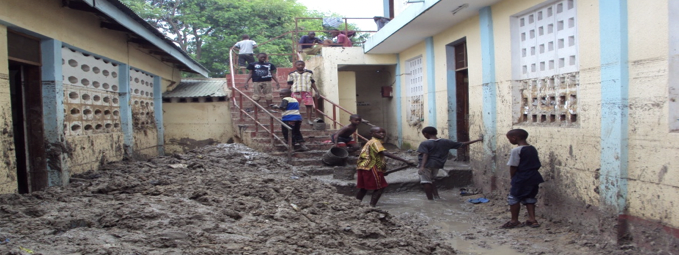 | Image 3.5. Flood damage observed within Luhanga Catholic Church premises. Source: Field survey (2025) |
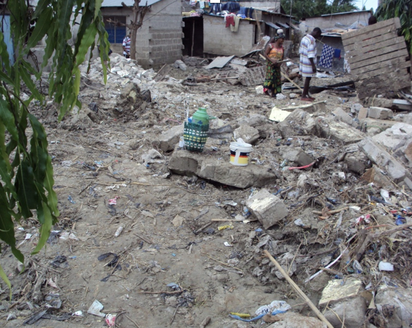 | Image 3.6. Flood damage observed beside Luhanga Catholic Church quaters. Source: Field survey (2025) |
3.3.2. Damage to MEMKWA Facilities
- Flooding also affected nearby MEMKWA educational facilities through inundation of classrooms, open spaces, and pedestrian circulation areas.
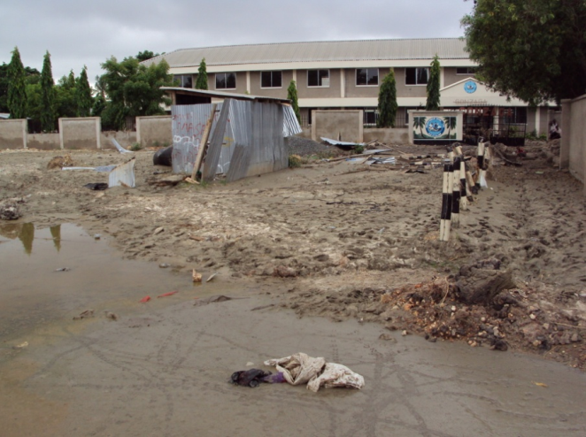 | Image 3.7. Flood impacts on MEMKWA premises. Source: Field survey (2025) |
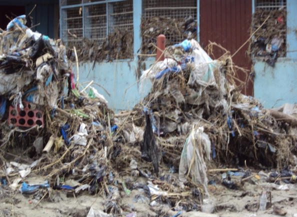 | Image 3.8. Damage at Memkwa premises. Source: Field Survey, (2025) |
3.3.3. Damage to Gonzaga Primary School
- Floodwaters disrupted educational activities at Gonzaga Primary School through damage to access routes, drainage infrastructure, and surrounding open spaces.
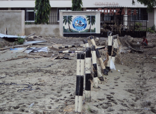 | Image 3.9. Flood impacts on Gonzaga Primary School. Source: Field survey (2025) |
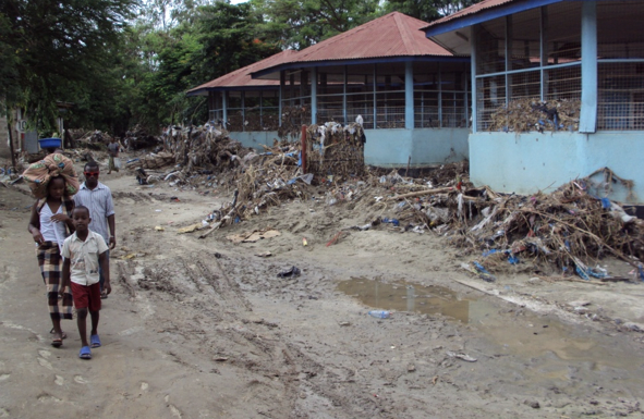 | Image 3.10. Flood impacts on Gonzaga Primary walkways. Source: Field survey (2025) |
3.3.4. Damage to Adjacent Residential Areas
- Neighbouring residential properties experienced repeated inundation, resulting in property damage, restricted accessibility, and increased public health risks associated with prolonged standing water.
4. Methodology
4.1. Research Design
- This study adopted a mixed-methods case study design, combining qualitative and quantitative research techniques to assess flood risk readiness and architectural mitigation strategies at Luhanga Catholic Church in Mabibo Ward, Kinondoni Municipality, Dar es Salaam. The case study approach was selected because it enables an in-depth investigation of a contemporary phenomenon within its real-life context, particularly where the boundaries between the phenomenon and its surrounding environment are not clearly defined [29]. This approach is widely applied in disaster risk reduction and urban planning research because it facilitates comprehensive understanding of complex interactions among physical, social, institutional, and environmental factors.The study further employed a survey strategy to collect empirical information from multiple stakeholder groups regarding flood experiences, preparedness measures, and perceptions of architectural and planning interventions [32].
4.2. Study Area
- The research was conducted at Luhanga Catholic Church, located in Mabibo Ward, Kinondoni Municipality, Dar es Salaam, Tanzania. The church compound occupies approximately 2 hectares and comprises the main church building, parish offices, Sisters' residences, and a hostel facility. The site is situated within a low-lying urban catchment approximately 8 km northwest of the city centre and is surrounded by high-density residential neighbourhoods and industrial developments. The area experiences recurrent flooding associated with overflow from adjacent stormwater channels, uncontrolled surface runoff, and inadequate drainage infrastructure, making it an appropriate case for examining institutional flood resilience.
4.3. Data Collection
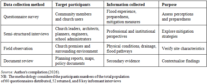
- Primary data were collected using four complementary methods:• structured questionnaire surveys;• semi-structured interviews;• direct field observations; and• document review.The questionnaire was designed to obtain information on respondents' experiences of flooding, perceived causes of flood risk, existing preparedness measures, and suggested mitigation strategies. Semi-structured interviews were conducted with key informants, including church leaders, school administrators, architects, engineers, and urban planners, to obtain expert perspectives on institutional preparedness and flood mitigation [10]. Field observations and photographic documentation were undertaken to assess the physical characteristics of the church premises, surrounding drainage systems, flood-prone locations, and existing architectural conditions. Relevant planning reports, policy documents maps, [32] and previous studies were also reviewed to complement the primary data.
4.4. Sampling Procedure and Participants
- The study adopted purposive sampling to identify respondents with direct knowledge and experience of flooding within the study area. Participants included representatives of Luhanga Catholic Church, nearby residents, school administrators, community leaders, architects, engineers, and town planners involved in urban development and infrastructure management.The inclusion of multiple stakeholder groups enabled the collection of diverse perspectives regarding flood occurrence, preparedness, and mitigation, thereby improving the comprehensiveness of the assessment. A total of 102 respondents participated in the study, comprising 19 church leaders, 32 community residents, 22 school administrators, 5 architects, 12 engineers, and 7 urban planners.
4.5. Data Analysis
- Qualitative data obtained through interviews and field observations were analysed using thematic analysis, whereby responses were coded, categorised, and organised into major themes relating to flood causes, vulnerability, preparedness, and architectural mitigation strategies.Quantitative questionnaire data were analysed using descriptive statistics, including frequencies and percentages, to summarise respondents' perceptions regarding flood occurrence, preparedness, and preferred mitigation measures. The combined use of qualitative and quantitative analyses facilitated a comprehensive understanding of flood risk within the study area [17].
4.6. Validity, Reliability, and Triangulation
- To enhance the credibility of the findings, the study adopted methodological triangulation by integrating evidence obtained from questionnaires, interviews, direct observations, photographic documentation, and document review. Information collected from one source was compared with evidence from other sources to improve consistency and minimise potential bias. The use of multiple respondent categories further strengthened the reliability of the findings by allowing cross-validation of stakeholder perspectives.
4.7. Ethical Considerations
- Participation in the study was voluntary, and respondents were informed of the purpose of the research before data collection commenced. Confidentiality and anonymity were maintained throughout the study, and information obtained was used solely for academic purposes. Permission to conduct field investigations within the church premises was obtained from the relevant church authorities.
4.8. Limitations of the Study
- The study was limited to a single institutional case study within Dar es Salaam, and therefore the findings may not be directly generalisable to all religious premises. Nevertheless, the research provides valuable empirical insights into architectural flood resilience within institutional environments and offers transferable lessons for similar flood-prone urban settings in Tanzania and other rapidly urbanising cities.
|
5. Discussion
5.1. Flood Vulnerability of Religious Premises within Rapidly Urbanizing Areas
- The findings demonstrate that the flood vulnerability of Luhanga Catholic Church is influenced by both natural hydrological processes and anthropogenic urban development. The church is strategically located within a low-lying section of Mabibo Ward, where runoff generated from upstream settlements converges before entering the Jangwani floodplain system. This geographical setting substantially increases the site's exposure to seasonal flooding.The results further indicate that rapid urbanization surrounding the church has intensified flood hazards. Expansion of impervious surfaces associated with residential development, industrial facilities, and road infrastructure has reduced natural infiltration while increasing stormwater runoff volumes. Similar observations have been reported in rapidly urbanizing African cities where uncontrolled urban growth significantly increases flood exposure and drainage system failure [6]; [36].Unlike residential buildings, religious premises perform multiple community functions, including worship, education, social services, and emergency shelter during disasters. Consequently, flood impacts on such facilities extend beyond physical infrastructure and directly affect community resilience and emergency response capacity.
5.2. Major Drivers of Flood Risk
- The study identified four principal drivers of flood vulnerability at Luhanga Catholic Church.First, the church is located between two interconnected stormwater channels whose hydraulic capacities have become inadequate for present runoff conditions. During heavy rainfall, the channels overflow and inundate adjacent land uses, including the church compound.Second, uncontrolled surface runoff from densely developed residential neighborhoods substantially increases water accumulation within the church premises. Extensive roof coverage, paved compounds, and limited permeable surfaces accelerate runoff generation while reducing groundwater recharge.Third, inadequate on-site stormwater drainage further compounds flood exposure. Existing drainage infrastructure lacks sufficient capacity and connectivity to rapidly convey runoff toward receiving channels, resulting in prolonged ponding after rainfall events.Finally, unplanned neighborhood development has created fragmented drainage patterns that redirect stormwater toward lower elevations occupied by the church. Similar relationships between informal urbanization, poor drainage planning, and flood vulnerability have been widely documented across Sub-Saharan African cities [3]; [4] and [24].Together, these findings demonstrate that flood risk at Luhanga Catholic Church is not solely a site-level problem but reflects wider deficiencies in urban planning, stormwater management, and catchment-scale development control.
5.3. Implications for Architectural Planning and Disaster Risk Reduction
- The study demonstrates that architectural design plays a critical role in strengthening flood resilience within institutional premises.Traditional approaches emphasizing structural flood protection alone are insufficient under conditions of increasing rainfall variability and rapid urbanization. Instead, flood-resilient architectural planning should incorporate integrated site design strategies that combine engineered drainage systems with landscape-based solutions [22]; [23] and [28].Potential interventions include raised floor levels, flood-resistant construction materials, suspended buildings, rainwater harvesting systems, permeable landscape surfaces, bioswales, retention ponds, and strategically designed evacuation routes. These approaches not only reduce direct flood damage but also improve the long-term operational continuity of institutional facilities.The findings therefore support contemporary disaster risk reduction frameworks that advocate integrating architecture, landscape planning, urban drainage engineering, and ecosystem-based adaptation into institutional development [13]; [35].
5.4. Religious Institutions as Critical Community Infrastructure
- One important contribution of this study is the recognition of religious premises as essential components of urban resilience systems.Unlike many public facilities, churches remain continuously accessible to surrounding communities before, during, and after flood events. Besides providing spaces for worship, they frequently function as temporary shelters, emergency coordination centers, food distribution points, and psychosocial support facilities.Despite these important functions, religious institutions have received limited attention within urban flood resilience literature. The findings therefore suggest that disaster preparedness policies should explicitly recognize churches and other faith-based institutions as critical community infrastructure requiring targeted flood mitigation investments.Such recognition would improve disaster preparedness while strengthening collaboration between local governments, faith-based organizations, urban planners, architects, engineers, and emergency management agencies.
5.5. Comparison with Previous Studies
- The findings generally agree with previous studies conducted in Dar es Salaam and other rapidly urbanizing African cities, which identify informal urban growth, inadequate drainage infrastructure, and weak land-use planning as primary contributors to urban flooding [6]; [36].However, this study extends existing knowledge by focusing specifically on religious premises. While previous investigations have primarily examined residential neighborhoods or city-scale flood management, relatively little attention has been devoted to institutional facilities that perform multiple social and emergency functions.From an architectural perspective, the study demonstrates that flood resilience should not be viewed solely as an engineering problem but as an interdisciplinary planning challenge requiring coordinated architectural design, landscape architecture, urban planning, and disaster risk governance.This contribution broadens current understanding of institutional resilience within rapidly urbanizing cities of the Global South and provides evidence for incorporating faith-based facilities into future disaster risk reduction planning.
6. Conclusions, Implications, and Recommendations
6.1. Key Findings
- This study assessed flood risk readiness and architectural mitigation strategies at Luhanga Catholic Church, a religious institution located within the flood-prone urban environment of Mabibo Ward, Dar es Salaam. The findings demonstrate that flood vulnerability results from the interaction of hydrological conditions, urban development patterns, and deficiencies in site planning and infrastructure.The principal findings are summarized as follows:1. Stormwater channel overflow is the primary hydrological source of flooding. The church is located between major and minor drainage channels that exceed their carrying capacity during periods of intense rainfall.2. Surface runoff from surrounding settlements substantially increases flood exposure. High-density residential development surrounding the church generates large volumes of runoff that are directed toward the lower-lying church compound.3. Urban impervious surfaces intensify runoff generation. Expansion of industrial facilities, roads, and paved areas has reduced natural infiltration and increased stormwater discharge into the urban drainage network.4. Inadequate on-site drainage infrastructure significantly limits flood management capacity. Existing drainage systems are undersized, poorly connected, and lack complementary measures such as rainwater harvesting and detention facilities.5. Rapid and largely unplanned urbanization has increased flood risk by encouraging development within natural flood corridors and environmentally sensitive areas.6. Institutional preparedness remains limited. Existing flood management efforts are predominantly reactive rather than preventive and are insufficient to address increasing rainfall intensity associated with climate variability.Collectively, these findings indicate that flood risk at Luhanga Catholic Church is not solely a site-specific problem but reflects broader deficiencies in urban planning, stormwater management, and institutional disaster preparedness.
6.2. Implications for Architecture and Urban Planning
- The study demonstrates that architectural planning should be recognized as a central component of disaster risk reduction within institutional developments.Rather than relying exclusively on engineering interventions, flood resilience should be integrated into every stage of architectural planning, including site selection, landscape design, building configuration, drainage planning, and infrastructure coordination.The findings further suggest that religious institutions should be incorporated into municipal disaster preparedness frameworks because they frequently function as emergency gathering centres, temporary shelters, and community support facilities during flood events.Consequently, future planning policies should integrate architects, urban planners, engineers, landscape architects, environmental specialists, and disaster management authorities within a common flood resilience planning framework.
6.3. Recommended Flood Mitigation Strategies
- Based on the findings, the following integrated mitigation strategies are recommended.
6.3.1. Structural Measures
- Structural interventions should prioritize reducing direct flood exposure through engineered infrastructure, including:• construction of reinforced riverbank protection structures (dikes) along vulnerable stormwater channels;• expansion and rehabilitation of existing drainage channels;• installation of additional stormwater conveyance systems;• localized flood retention and detention facilities; and• hydraulic improvements that increase channel carrying capacity.The proposed structural interventions are illustrated in Image 6.1 and 6.2:
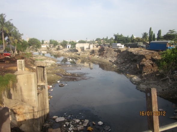 | Image 6.1. Comparative flood impact showing protected and unprotected riverbank sections. Source: Field survey. (2025) |
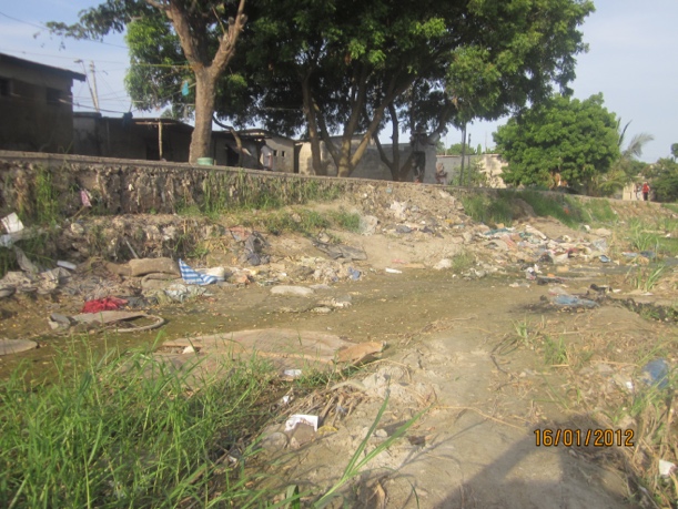 | Image 6.2. Differential flood exposure along Kigogo Mbuyuni river valley (Field Survey). Source: Field survey. (2025) |
6.3.2. Architectural Measures
- Flood-resilient architectural design should incorporate:• elevated floor levels;• suspended or pile-supported buildings where appropriate;• flood-resistant construction materials;• waterproof basements;• protected entrances and openings;• roof spaces designed as temporary refuge areas;• raised utility installations above anticipated flood levels.Illustrative architectural concepts are presented in sketches 6.3–6.13 and images 6.14-6.20.Earth Traverse Installation: Surface runoff from the northern unplanned settlement necessitates an earth traverse with a 900 mm × 600 mm drainage channel. Reinforcement with stones and grass improves soil stability.
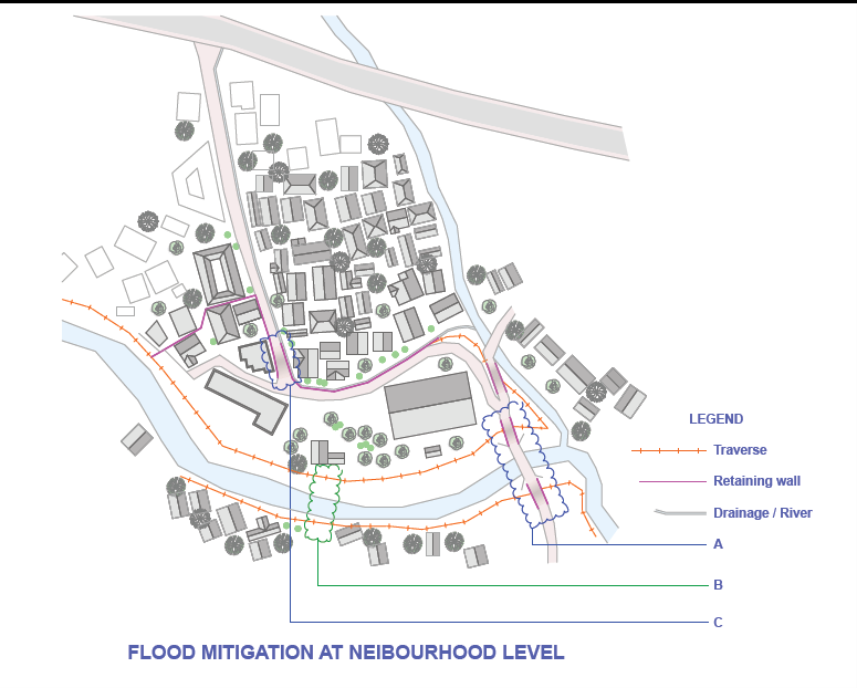 | Sketch 6.3. Neighborhood-level flood mitigation intervention. Source: Field survey, (2025) |
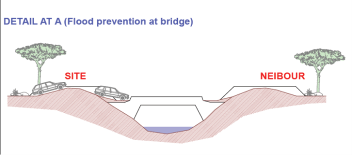 | Sketch 6.4. Bridge-level, Detail at A (flood impact and drainage) constraint observations Source: Field Survey, (2025) |
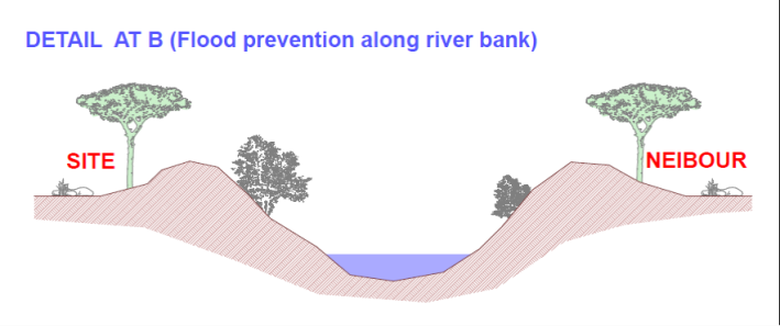 | Sketch 6.5. Shows the detail at B (Flood prevention along river bank). Source; Field survey Source; Field survey (2025) |
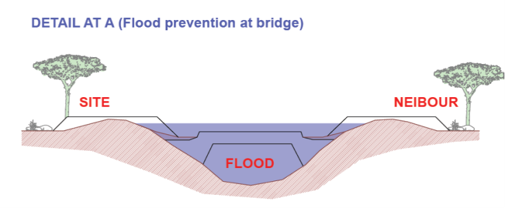 | Sketch 6.6. Shows the detail at A (Flood prevention along river bank with overflowing water). Source: Field survey (2025) |
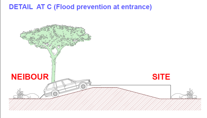 | Sketch 6.7. Shows the detail at C (Flood prevention at the main entrance without water). Source: Field survey (2025) |
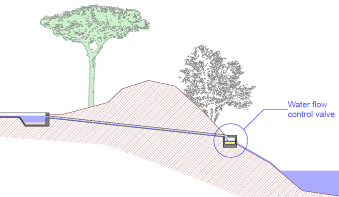 | Sketch 6.8. Shows Flood prevention river bank flow, when water level is high. Source: Field survey, (2025) |
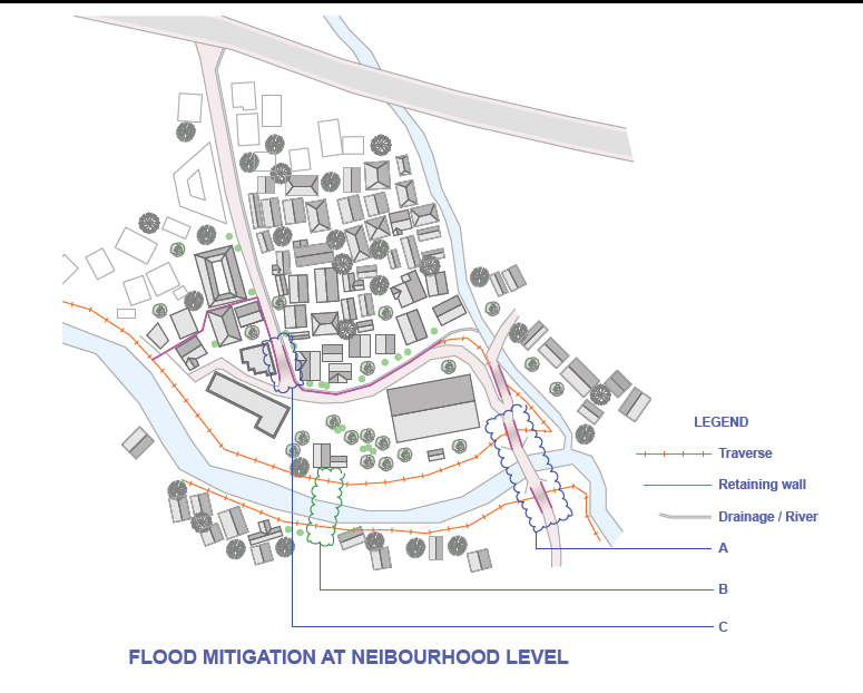 | Sketch 6.9. Neighborhood-level flood mitigation intervention. Source: Field survey, (2025) |
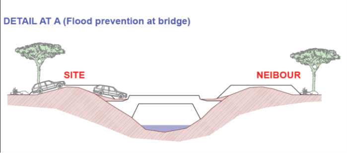 | Sketch 6.10. Bridge-level flood impact and drainage constraint observations Source: Field survey, (2025) |
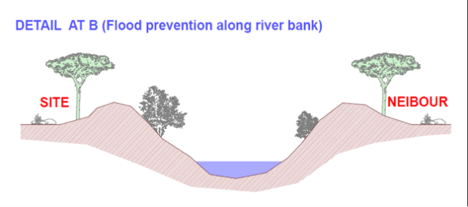 | Sketch 6.11. Shows the detail at B (Flood prevention along river bank). Source; Field survey Source; Field survey (2025) |
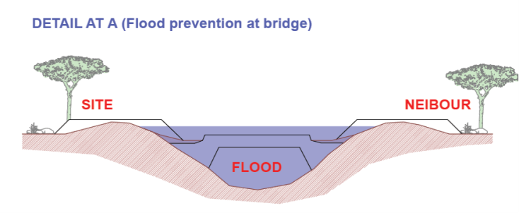 | Sketch 6.12. Shows the detail at A (Flood prevention along river bank with overflowing water). Source: Field survey (2025) |
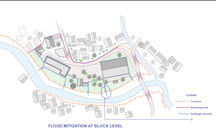 | Sketch 6.13. Shows the flood mitigation block level. Source: Field survey, (2025) |
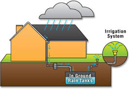 | Image 6.14. Shows harvesting rain water to reduce surface runoff. Source: Field survey. (2025) |
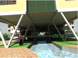 | Image 6.15. Shows the mixed use suspended building with flood precautions. Source: Field survey, (2025) |
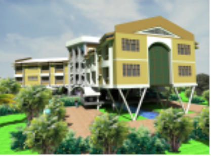 | Image 6.16. Shows the safe zones/building with suspended piles for flood precautions. Source: Field survey, (2025) |
 | Image 6.17. Shows the landscape flood control by planting trees. Source: Field survey, (2025) |
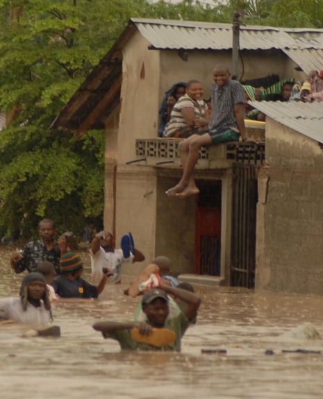 | Image 6.18. Shows the flood proof roof structure. Source: Field survey, (2025) |
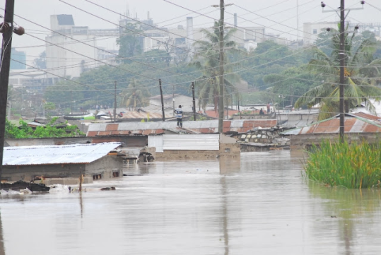 | Image 6.19. Shows the areas prone to earth quakes at Luhanga river bay. Source: Field survey, (2025) |
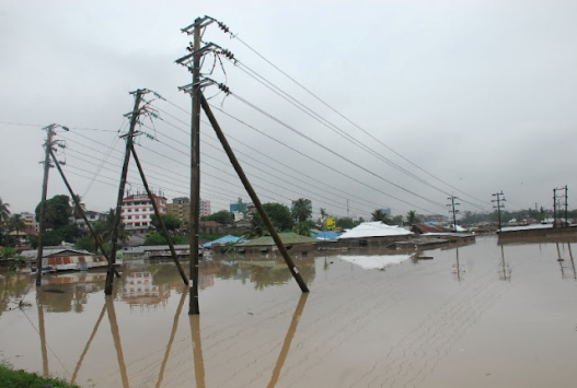 | Image 6.20. Shows the areas prone to flood at Jangwani wetland. Source: Field survey, (2025) |
6.3.3. Landscape-Based Solutions
- Nature-based flood mitigation measures should complement engineered infrastructure through:• rainwater harvesting systems;• permeable landscape surfaces;• bios wales and infiltration areas;• strategic tree planting;• reduction of impervious surfaces; and• ecosystem-based stormwater management.These interventions simultaneously reduce runoff, improve groundwater recharge, and enhance environmental sustainability.
6.3.4. Urban Planning Measures
- Flood resilience cannot be achieved through site-level interventions alone.Municipal authorities should strengthen:• enforcement of land-use planning regulations;• protection of natural drainage corridors;• coordinated stormwater infrastructure planning;• informal settlement upgrading;• integrated watershed management; and• routine maintenance of urban drainage systems.These measures require collaboration among local government authorities, urban planners, engineers, architects, environmental agencies, and local communities.
6.4. Policy Recommendations
- The study recommends that local authorities incorporate institutional facilities such as churches, schools, and health centres into urban flood resilience planning.Specifically, policy should promote:• mandatory flood risk assessments for institutional developments;• flood-resilient architectural design standards;• integration of nature-based solutions into urban planning regulations;• institutional emergency preparedness plans;• periodic inspection and maintenance of drainage infrastructure; and• community participation in disaster preparedness programmes.Such policy interventions would strengthen urban resilience while protecting critical community infrastructure.
6.5. Study Contribution
- This study contributes to disaster risk reduction and architectural planning literature in three important ways, namely:First, it demonstrates that religious institutions represent an underexplored yet strategically important component of urban resilience systems within rapidly urbanizing African cities.Second, it proposes an integrated architectural flood resilience framework that combines engineering infrastructure, landscape design, and urban planning approaches.Third, it provides empirical evidence from Dar es Salaam that may inform flood mitigation planning for similar institutional developments across Sub-Saharan Africa.
6.6. Limitations and Future Research
- The study focused on a single institutional case study within Dar es Salaam. Although the findings provide valuable insights into flood risk management for religious premises, they cannot be generalized to all institutional settings without caution.Future research should compare multiple religious institutions across different flood-prone urban environments and evaluate the long-term performance of architectural mitigation strategies under changing climatic conditions.
6.7. Conclusions
- Flood vulnerability at Luhanga Catholic Church is shaped by the interaction of hydrological processes, inadequate drainage infrastructure, and rapid unplanned urbanization. The study demonstrates that effective flood resilience requires a shift from reactive flood response toward proactive planning that integrates architecture, engineering, landscape design, and urban planning.The proposed mitigation strategies offer practical guidance for improving institutional preparedness while strengthening urban resilience in rapidly growing cities. More broadly, the findings highlight the importance of recognizing religious institutions as critical community infrastructure within disaster risk reduction planning. By integrating flood-resilient architectural design with coordinated urban planning and community participation, cities can significantly reduce flood impacts and enhance the adaptive capacity of vulnerable institutions.
ACKNOWLEDGEMENTS
- The author gratefully acknowledges the cooperation and support provided by the leadership of Luhanga Catholic Church, residents of Mabibo Ward, local government officials, and the architects, engineers, planners, and community members who participated in this study. Their valuable insights and field experiences greatly enriched the research.