Henry M. Rimisho
Ardhi University (ARU), P.O. Box 35176, Dar es Salaam, United Republic of Tanzania
Correspondence to: Henry M. Rimisho, Ardhi University (ARU), P.O. Box 35176, Dar es Salaam, United Republic of Tanzania.
| Email: |  |
Copyright © 2026 The Author(s). Published by Scientific & Academic Publishing.
This work is licensed under the Creative Commons Attribution International License (CC BY).
http://creativecommons.org/licenses/by/4.0/

Abstract
Informal settlements developed on rocky hill landscapes present distinctive architectural, spatial, and construction challenges that are rarely addressed within conventional urban planning frameworks. This study investigates house typologies and spatial organization in two informal settlements Mabatini and Nyambiti C in Mwanza City, Tanzania. The research examines the relationship between topography, rocky terrain, construction materials, spatial use, and household socio-economic characteristics. Using field surveys, interviews, and direct observation, twenty-five residential units were documented and analyzed. Through typological classification, eight dominant house types were identified, each reflecting adaptive responses to steep slopes, exposed rock formations, irregular plots, and limited financial resources. Findings reveal that residents demonstrate high levels of spatial ingenuity by integrating rocks into foundations, boundaries, circulation paths, and outdoor living spaces. Housing forms are flexible, incremental, and multifunctional, responding dynamically to household needs and terrain constraints. The study argues that informal housing on rocky hills should not be perceived as chaotic or substandard but as a contextually responsive architectural practice. The paper concludes by recommending participatory design approaches, supportive planning frameworks, geological assessments, and professional engagement to enhance safety, functionality, and sustainability in similar settlements.
Keywords:
Informal settlements, House typology, Rocky hills, Mwanza City, Spatial organization, Participatory design
Cite this paper: Henry M. Rimisho, House Typologies and Spatial Organization in Informal Settlements on Rocky Hills - The Case of Mabatini and Nyambiti C, Mwanza City, Tanzania, Architecture Research, Vol. 16 No. 1, 2026, pp. 1-20. doi: 10.5923/j.arch.20261601.01.
1. Introduction
Rapid urbanization in Sub-Saharan Africa has intensified the growth of informal settlements, particularly among low-income populations who are excluded from formal housing markets as reported by [22]. In Tanzania, informal settlements account for a substantial proportion of urban housing as clearly described by [16], often occupying environmentally sensitive and topographically challenging areas such as river valleys, wetlands, and rocky hills. Despite their prevalence, these settlements remain marginal in planning discourse and architectural research.In Mwanza City, the presence of extensive granite rock outcrops and steep hills has significantly influenced settlement patterns, this was reported by Ministry of Lands, Housing human settlement, [18]. Areas such as Mabatini and Nyambiti C have evolved organically through incremental development, land invasion, and self-construction, resulting in unique housing forms and spatial organizations shaped by terrain constraints. Houses are constructed without formal layouts, professional supervision, or standardized regulations, yet they display functional order, adaptability, and social logic, which was discussed at length by [24].This research focuses on the classification and analysis of house typologies and spatial organization in informal settlements located on rocky hills. It seeks to understand how residents negotiate steep slopes, exposed rocks, irregular plots, and limited resources to create habitable environments. By examining house forms, layouts, space use, and construction practices, the research contributes empirical evidence toward rethinking informal settlements as adaptive architectural systems rather than planning failures.
2. Literature Review
Typological analysis has long been employed in architectural research as a method for understanding patterns of form, space, and use within residential environments as guided by [9]. Scholars emphasize that house typologies reflect social organization, cultural practices, economic capacity, and environmental conditions as discussed by [10] and [9]. In formal housing, typologies are often shaped by stylistic conventions, regulatory frameworks, and standardized layouts. However, in informal settlements, typologies emerge organically through daily practices, incremental construction, and negotiation with site constraints as proposed by [7] and [11].Studies on informal settlements highlight flexibility, multifunctionality, and adaptability as defining characteristics of informal housing as pinpointed by [12] and [6]. Spatial organization often blurs the distinction between public and private realms, with outdoor spaces functioning as extensions of domestic life. Scholars further note that environmental conditions, such as slope, soil stability, and climate, all play a critical role in shaping housing form, orientation, and clustering as studied by Ministry of Lands, Housing Development [19].In settlements located on rocky hills, physical constraints become primary determinants of architectural form as learnt by [9]. Exposed rock formations influence plot boundaries, circulation paths, foundation systems, and building orientation. Steep slopes necessitate split-level arrangements, stepped circulation, and terraced outdoor spaces. These conditions result in irregular house shapes and non-linear settlement patterns that challenge conventional planning norms as shared by [26].House types in this study are defined based on spatial and physical characteristics, including form, layout, number of rooms, plot configuration, roof type, construction materials, and interaction with rocky terrain. Figure 2.1 illustrates the conceptual and operational framework used to analyze house typologies, adapted from established typological models and modified to reflect the informal and topographically complex context of Mwanza’s rocky City.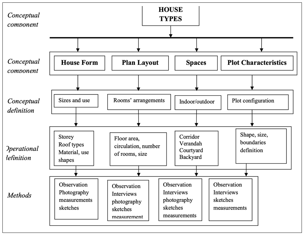 | Figure 2.1. The Conceptual and operational components for analysing houses types. Source: [24] as modified by the author, 2025 |
“The Terrain-Adaptive Type demonstrates how spatial organization emerges through direct negotiation with exposed rock formations and slope gradients, consistent with the study’s terrain-responsive conceptual framework.”
2.1. House Type Classification
House type classification provides a systematic framework for understanding residential design variations based on spatial, functional, and physical characteristics. According to [8], house types may be interpreted and organized through different classificatory approaches depending on the analytical objectives of a study. Similarly [9], argues that housing classification is context-dependent, with different criteria producing different but equally meaningful typologies.In informal settlements, naming and classification of house types are important analytical tools for distinguishing spatial patterns and identifying recurring housing forms. Classification enables comparison between housing configurations while revealing how residents adapt built forms to environmental conditions, household needs, and available resources. In the present study, house types were classified according to spatial organization, form, room arrangement, and interaction with rocky terrain, allowing identification of distinct adaptive housing patterns within the study settlement as suggested by [10].
2.2. Space and Space Use
Spatial organization in residential environments is closely associated with privacy, accessibility, and patterns of social interaction. The use of space is often determined by the degree of control exercised by individuals or communities over particular areas. According to [13], public space refers to areas that are collectively accessible and not under exclusive individual control. Such spaces support social interaction and shared activities within the settlement environment.Studies on informal settlements demonstrate that spatial boundaries between private, semi-private, communal, and public spaces are often fluid and multifunctional as shown by [13], as cited also in his writings by. Private spaces generally accommodate household-specific activities such as sleeping, cooking, and storage, while semi-private spaces, including verandas, entrances, and front thresholds, facilitate interaction between neighbours and support children’s play activities. Communal spaces function as neighbourhood gathering areas, whereas public spaces serve broader urban functions.In informal settlements such as Mabatini and Nyambiti C, outdoor spaces play a significant role in everyday domestic and social life due to limited indoor space and irregular plot configurations. Spatial organization is strongly influenced by terrain conditions, plot subdivision patterns, and accessibility constraints. Because plot boundaries are informally established and difficult to measure precisely, this study did not employ plot ratio or plot area as analytical variables. Instead, plot exposure was adopted as a more suitable indicator, referring to the number of building sides connected to communal pathways or public open spaces as clearly noted by [15].i) Public space- space in an urban area for the whole city. [figure 2.2]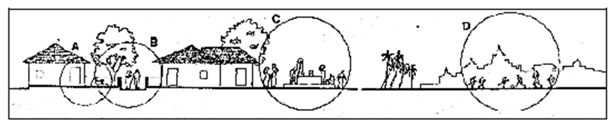 | Figure 2.2. Demonstration of hierarchy of spaces, where private, semi-private, and communal spaces are identified. Source: [13] as cited by the author, 2025 |
In informal settlements such as Mabatini and Nyambiti C, plot dimensions and size are determined by informal land subdivision in which plot areas and plot ratio cannot easily be identified; hence in the present study, plot ratio and plot area were not considered since they depend very much on knowing the exact measurement of a plot. On the other hand, plot exposure, as a variable in analyzing plot characteristics in informal settlements as said by [13], was employed because it is a variable that can be easily identified under the assumption that exposure refers to the number of sides the building is connected to the public open space or communal pathways.
2.3. House types in Dar-es-Salaam, Tanzania
Previous studies in Tanzania have documented the evolution of house typologies in informal settlements, particularly in Hanna Nassif, Dar es Salaam as argued by [21]. The study identified several dominant house forms, including rooms-in-line, urban Swahili, modified Swahili, L-shaped, U-shaped, and two-storey typologies. These housing forms emerged incrementally through self-construction processes and adaptation to changing household needs.The findings from Hanna Nassif indicate that informal housing development often occurs outside formal design standards, resulting in flexible and evolving housing configurations [30]. Outdoor spaces were observed to be limited but functionally integrated with indoor activities, highlighting the importance of external spaces in supporting domestic life. Housing transformation was further associated with socio-cultural change, economic conditions, technological adaptation, and changing household demands as said by [21].Although the physical context of Dar es Salaam differs from the rocky hill terrain of Mwanza City, these studies provide an important comparative basis for understanding typological variation and incremental housing processes in Tanzanian informal settlements as echo by Ministry of Lands, Housing Development, [19]. The present study extends this body of knowledge by examining how steep topography and exposed rock formations influence house typologies and spatial organization in rocky hill environments.
3. Methodology
This study adopted a mixed-methods case study approach combining qualitative and quantitative techniques to investigate house typologies and spatial organization in the informal settlements of Mabatini and Nyambiti C in Mwanza City, Tanzania. The approach enabled examination of both the physical characteristics of housing and the socio-spatial practices associated with informal settlement development as discussed by [27].
3.1. Study Area and Sampling
Mabatini and Nyambiti C were selected because of their pronounced rocky hill topography, extensive informal housing development, and varied terrain-responsive settlement patterns [5]. A purposive sampling strategy was employed to identify housing units representing different spatial configurations, construction forms, terrain conditions, and stages of incremental development.A total of 25 housing units were documented, including 13 houses in Mabatini and 12 houses in Nyambiti C. The selected houses reflected variation in layout, plot arrangement, building orientation, room configuration, and adaptation to rocky terrain as read by [29].
3.2. Data Collection
Data collection was conducted through field surveys, direct observation, interviews, spatial documentation, and typological analysis [17].Field Surveys and ObservationPhysical measurements, field sketches, photographs, and spatial observations were undertaken for each selected house. Particular attention was given to house form, circulation patterns, plot conditions, construction materials, slope adaptation, and the relationship between buildings and exposed rock formations as clarified by [25].InterviewsSemi-structured interviews were conducted with household heads, local leaders, and local artisans to understand housing construction processes, spatial use patterns, decision-making practices, and incremental housing transformations as shown by [2]. Interviews also explored residents’ responses to terrain constraints, financial limitations, and environmental conditions.Spatial Documentation and Typological AnalysisSpatial mapping techniques were used to document building orientation, circulation networks, slope gradients, plot exposure, and proximity to rock outcrops. According to [4] houses were subsequently classified into typological categories based on spatial layout, room arrangement, roof form, construction materials, and terrain adaptation strategies.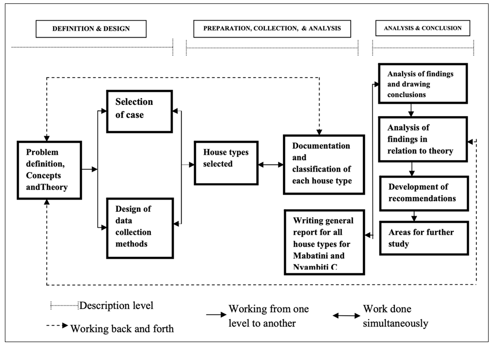 | Figure 3.1. Research framework and methodological process. Source: Adapted from [14], modified by the author, 2025 |
3.3. Data Analysis
The collected data were analyzed using descriptive statistics, comparative typological analysis, and visual spatial interpretation were elaborated by [15] and [14]. Field observations, interview responses, sketches, and photographic documentation were triangulated to identify recurring spatial patterns and adaptive housing strategies.The analysis focused on:• spatial organization,• house form and layout,• indoor and outdoor space use,• construction practices,• and adaptation to rocky terrain.The identified patterns were synthesized into distinct house typologies reflecting the interaction between environmental constraints, socio-economic conditions, and incremental housing processes.
4. Analysis, and Discussions
4.1. Description of Mwanza City
Mwanza City is the administrative headquarters of Mwanza Region and Tanzania’s second-largest urban center. Located on the southern shores of Lake Victoria at latitude 1°03′ S and longitude 34°10′ E, the city covers approximately 1,337 km², of which 900 km² is water. Administratively, Mwanza comprises Nyamagana and Ilemela districts, encompassing 21 wards, 481 sub-wards, and 72 hamlets.Urban development in Mwanza is characterized by rapid expansion and limited formal planning capacity. Approximately 86.8 km² of the city is urbanized, with informal settlements occupying steep and rocky hill areas that are unsuitable for conventional development.
4.1.1. Existing Settlement Structure
It is estimated that 65,000 housing units in Mwanza City, about 49,000 (75%), are located in unplanned settlements as explained by Cadstedt, (2006). These areas exhibit irregular layouts, narrow footpaths, and diverse construction materials, reflecting incremental and self-built development.
4.1.2. Economic Activities
Commerce dominates the city’s economy, employing over 7,700 people in retail and wholesale trade. Fishing, small-scale industries, and informal enterprises provide livelihoods for residents of hill settlements.
4.1.3. Fishing, Industry, and Tourism
Fish processing industries and related activities offer employment opportunities, while Mwanza’s scenic rocky landscape and proximity to national parks present untapped tourism potential.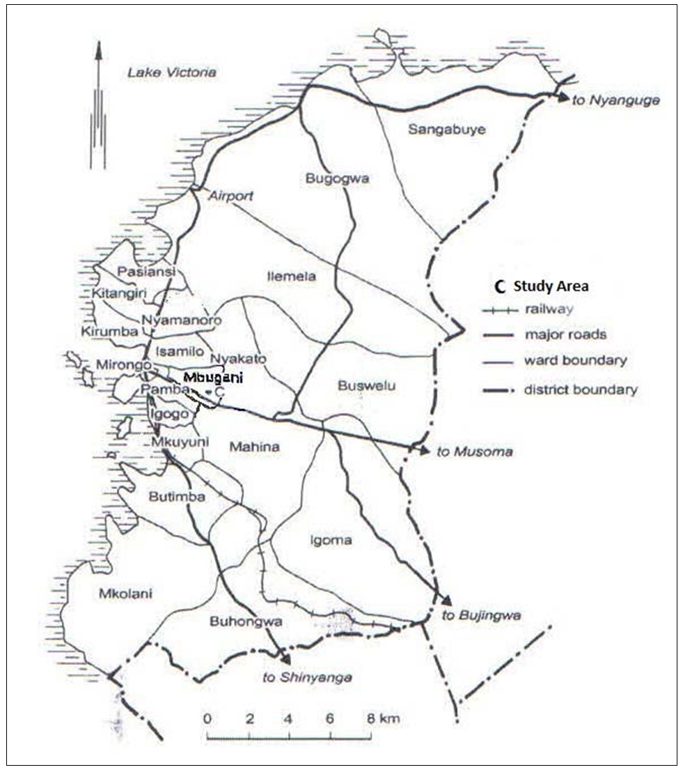 | Figure 4.1. Mwanza City administrative boundaries, its wards, and the location of the study area. Source: Adapted from Google Earth 2025 as modified by the author, 2025 |
4.2. Reseach Area: Mabatini
Mabatini is located approximately 2 km east of Mwanza city center in Mbugani Ward, Nyamagana District. The settlement is divided into Mabatini North (Mtoni Hill) and Mabatini South (Makamba Hill). The name “Mabatini” originated in the 1970s following the construction of the first iron-roofed house in the area.The settlement is characterized by granite rock outcrops, steep slopes, and incremental housing development. Access to major roads and public transport facilitates connectivity to urban services. Construction is largely self-initiated, relying on informal knowledge networks, local artisans, and household labor.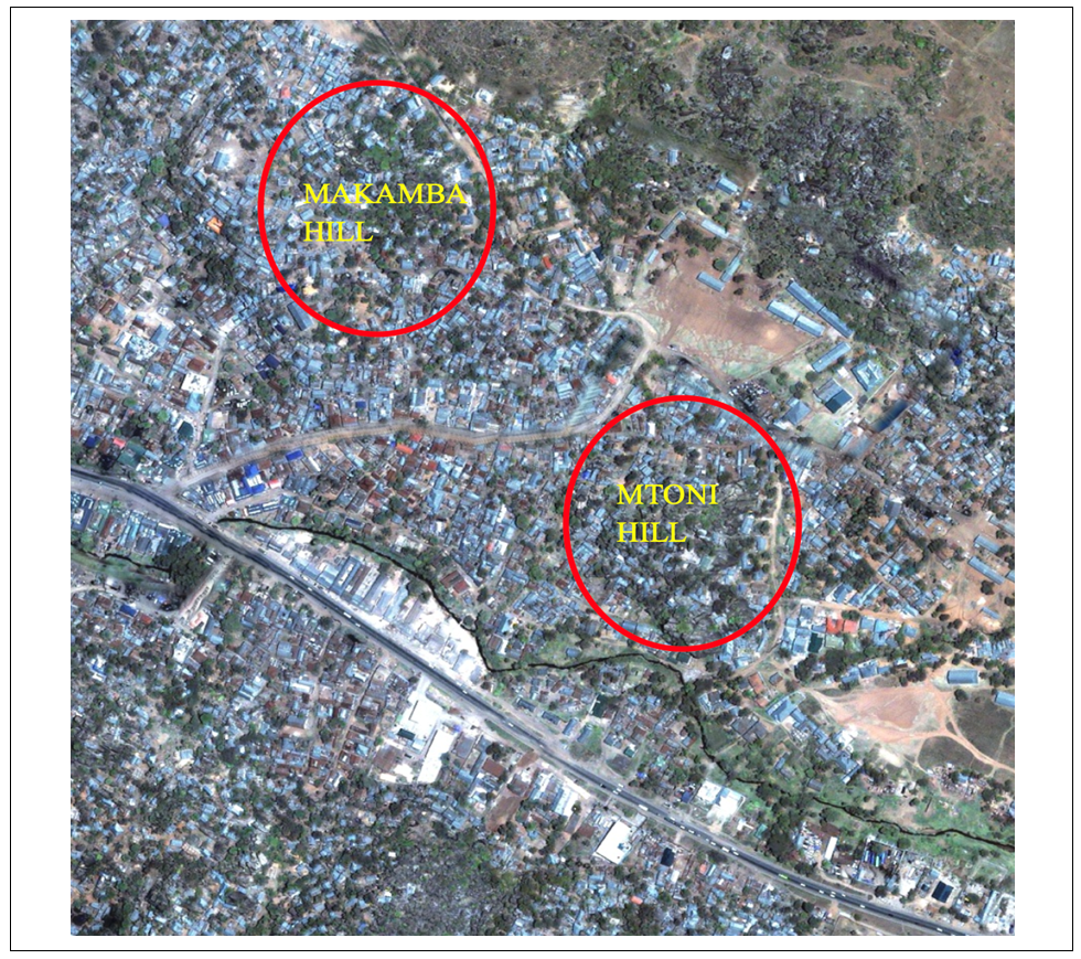 | Figure 4.2. Makamba Hill and Mtoni Hill in Mabati: Source: Adapted from Google Earth band modified by the author, 2025 |
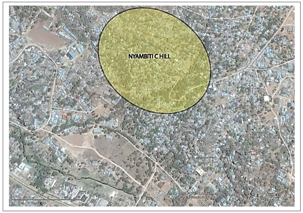 | Figure 4.3. Nyambiti C area. Source: Adapted from Google Earth and modified by the author, 2025 |
4.3. Housing on Rocky Hills
Housing conditions range from permanent to temporary structures, depending on household income and construction phase. Plot sizes vary significantly, and slopes range between 25° and 70°, far exceeding recommended planning standards by [20] and [1]. Circulation paths follow natural rock formations, creating stepped, winding access routes.Outdoor spaces serve as multifunctional areas for cooking, washing, social interaction, and play, while indoor spaces are primarily private. The integration of rocks into spatial organization contributes to both functional efficiency and visual identity.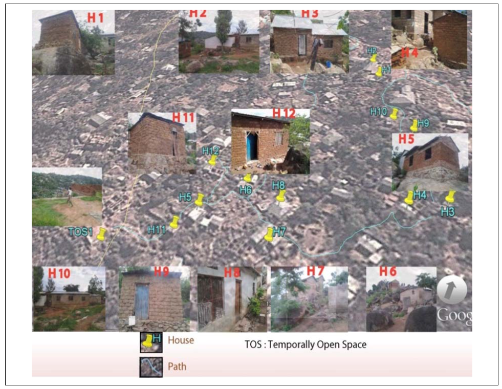 | Figure 4.4. Location of each house studied in Nyambiti C Source: Google Earth 2025 as modified by the Author’s fieldwork 2025 |
4.4. Classification of House Types
Based on the analysis of 25 houses, eight house typologies were identified [23]:1. Terrain Adaptive (Split-Level)2. Rooms in Line3. I-Shape4. Grouped5. T-Shape6. One-Room7. U-Shape8. L-Shape
4.4.1. Terrain Adaptive (Split-Level) Type
This typology is prevalent on steep slopes and demonstrates the highest level of terrain responsiveness. Houses are arranged along contour lines, with rocks forming foundations and boundaries. UN Habitat, (2003) elaborated clearly how outdoor circulation follows level differences, while interstitial spaces between rocks support multiple domestic functions. Rental rooms are commonly incorporated, enabling income generation.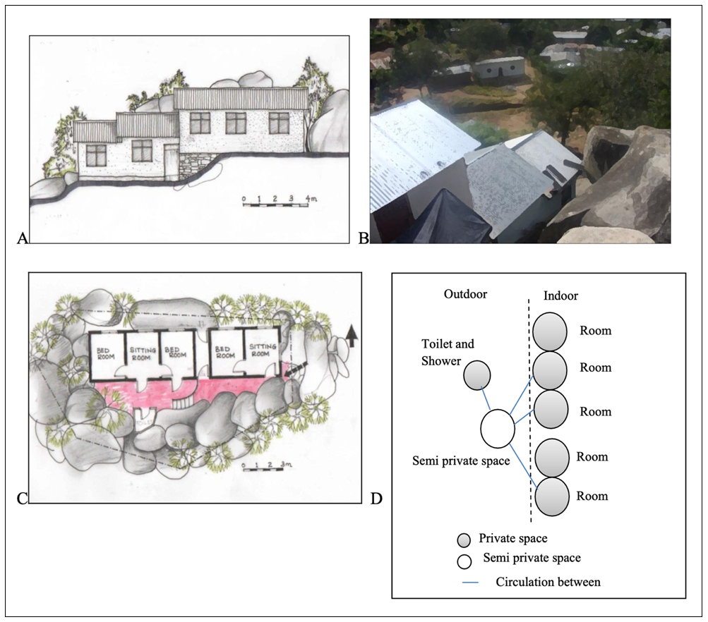 | Figure 4.5. A, B, C and D Terrain adaptive House type) Location of Mwanza City and the study settlements of Mabatini and Nyambiti C. Source: Adapted from [19]. Author’s fieldwork, 2025 |
4.4.2. Room in Line House Type
This type of house comprises more than one room and each room is independent. It is flexible for extension in either side of the house and in most cases the rooms in the house are constructed for the purpose of renting. The dwellers usually share the spaces available in front of the house as well as toilet and bath area. Whereas, the space in front of the house is shared, this space is limited to each room. There is no physical boundary of each space in front of the room but usually these boundaries are conceptual in which each dweller knows where his/her space start and ends. The rooms are used multifunctional for; sleeping, sitting, dinning and sometimes even cooking whereby a room becomes a house within the house.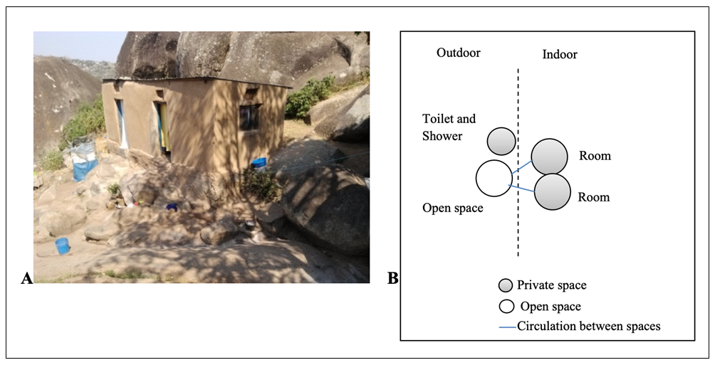 | Figure 4.6. A and B: Room-in-line house type. Source: Author’s fieldwork (2025) |
4.4.3. I-Shape House Type
This type of house consists of rooms arranged in line. Unlike rooms in line house type usually consists of two or three rooms and the living space is commonly located at the centre of two rooms. In the living room there is an entrance door opening direct to the front yard. The common room is used for different activities such as sitting, eating, sleeping and even cooking during the rainy season. It has usually no store, kitchen dinning or storage. Kitchen, toilet and bathroom are outdoor facilities in this type of house. This type of house seems to fulfill major demands of owner occupation requirements where one struggles to develop his/her house to avoid hassles associated with renting a room. In terms of design, the house is flexible to change and can expand when the needs arise. It is also cheap to construct since its plan is simple and familiar to many fundis (craftsmen). This type of house has no toilet/shower; the household uses the neighbour’s latrine for toilet and shower.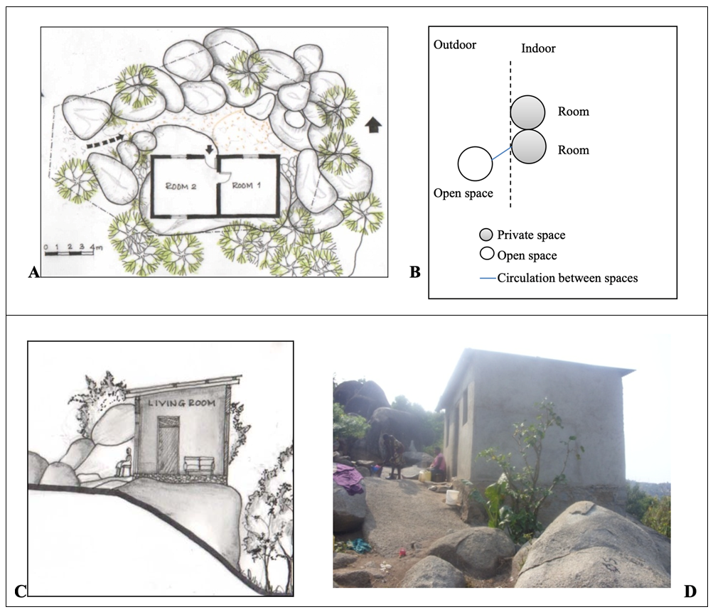 | Figure 4.7. A and B: I-Shape House type. Source: Author’s fieldwork (2025). [1], C and D: I-Shape House type. Source: Author’s fieldwork (2025). [2] |
This type of house consists of rooms arranged in line. Unlike rooms in line house type usually consists of two or three rooms and the living space is commonly located at the centre of two rooms. In the living room there is an entrance door opening direct to the front yard. The common room is used for different activities such as sitting, eating, sleeping and even cooking during the rainy season. It has usually no store, kitchen dining or storage. Kitchen, toilet and bathroom are outdoor facilities in this type of house. This type of house seems to fulfill major demands of owner occupation requirements where one struggles to develop his/her house to avoid hassles associated with renting a room. In terms of design, the house is flexible to change and can expand when the needs arise. It is also cheap to construct since its plan is simple and familiar to many fundis (craftsmen). This type of house has no toilet/shower; the household uses the neighbour’s latrine for toilet and shower. 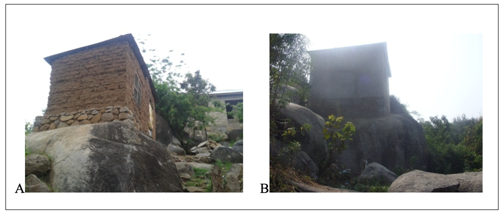 | Figure 4.8. A and B: House sitting on the rock platform |
In Nyambiti C Street, [Figure 4.8] it was revealed that almost all 13 houses surveyed, 11 houses sat on the rock platform and others sat partly on ground and partly on the rock surface.
4.4.4. One Room House Type
One room house type consists of a single interior space which is used for multiple activities such as cooking, eating, sleeping, and washing activities. The structure is either located at the centre or at the perimeter of the plot. Its structure is very flexible to change when the needs arise and it is built between the rocks. Even the roof type is usually selected according to anticipated changes that may take place in future. Commonly gable roof or mono pitches are most preferred roof style because they are easily adaptable to changes. Although the structure is very flexible to changes, this is usually determined by the existence of boulder rocks within the plot. The presences of large rocks within the plot sometimes make it difficult for the dweller to do an extension to the building even if a need arises. 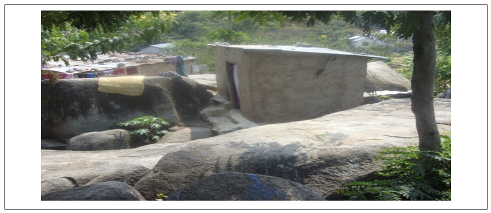 | Figure 4.9. One room House type. Source: Author’s fieldwork study 2025 |
4.4.5. Grouped House Type
These are group of house types that are organized into one plot or in different plots. Due to existence of rocks, these types of houses have been arranged according to the available spaces in between the rocks within the site room one house to and there is sometimes great difference in level from one house to another. They usually consist of large extended family units deciding to live together or they find themselves living side by side intuitively used in this form of house type. The open space in between the building is used for multifunction purpose. 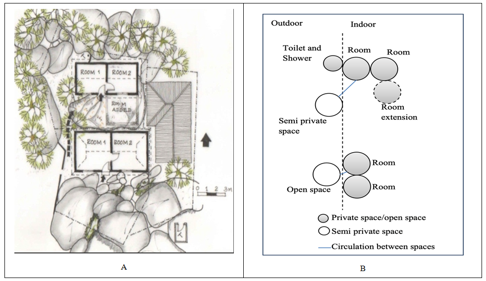 | Figure 4.10. Grouped House type [A]. Source: Author’s fieldwork study 2025, Grouped House type [B]. Source: Author’s fieldwork study 2025 |
4.4.6. T-Shape House Type
This type of house consists of four to five rooms for sleeping and the other room for living. There is one tenant in this house and the room for tenant has different entrance from other rooms which is accessed from the front yard. The facilities such as toilets and shower are located in the backyard separated from the main house and are shared by the owner and the tenant. On one side of the backyard space, there is large boulder of rocks which acts as a boundary and small rocks within the yard which create difficult in maximum use of backyard. There is a small hut attached to the main house which is used for raising chicken and ducks and sometimes used as storage. Though there is no electricity but there is tap water in the backyard space which is also shared by both tenant and the owner. On the front yard there are small rocks located just close to the entrance of the tenant’s room which create difficulties in using the space, However, it is used to dry the clothes and food. Source: Author’s fieldwork study 2025.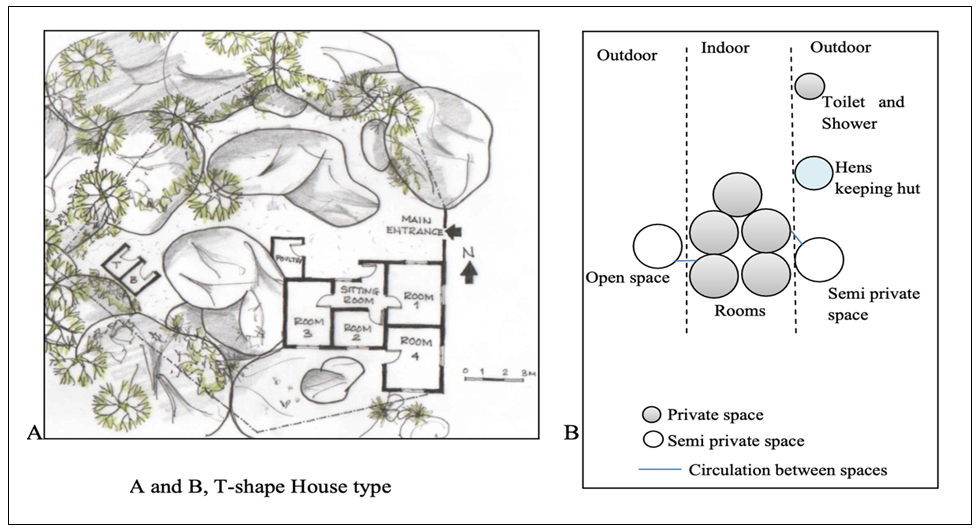 | Figure 4.10. [B] one room House type. T-Shape. Source: Author’s fieldwork study 2025 |
4.4.7. U- shape House Type
This building contains eight rooms, two are occupied by the landlord and his wife and the rest are rented by families up to a total of twenty-one members. It is a combination of rooms- in-line house type and L-shape house type joined together to form U-shape house type. The entire households share the same courtyard whereby several activities like cooking, cleaning go on during most hours of day time. Apart from these activities there is animal keeping and just out of the courtyard there is a small shop and children play area. According to the residents here, there is limited space for daily activities in the courtyard and also the area is not safe for children to play because of the stones. Toilet, shower and storage are attached between the wall of house and boundary near the main entrance door to the houses, and there is small hut for chicken and ducks keeping. The pit hole is located just outside where the toilet and shower are located and connected to the pipe which facilitates the drainage of waste water from the toilet and shower. Each room has entrance doors which open direct to the courtyard and there is no verandah or entrance lobby to each room. Through observation, it was seen that stones were used as seats, place to dry clothes as well as food drying platform like wheat. 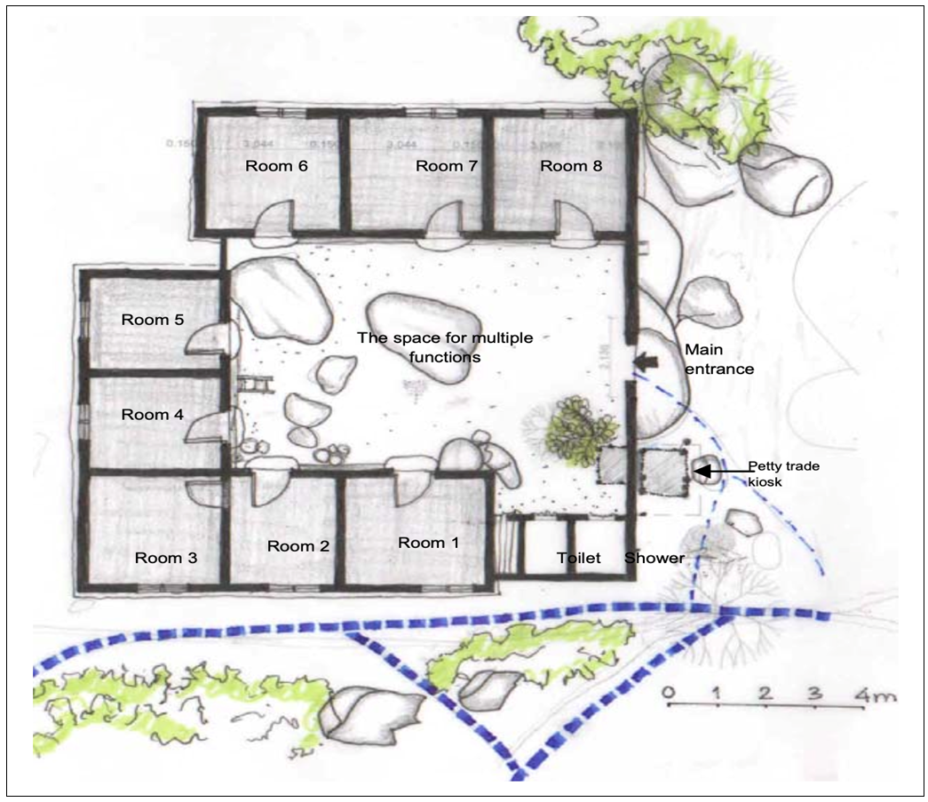 | Figure 4.11. U- shape house type with courtyard at the centre. The dotted and bold lines are the main pathway while the dotted thin line is accessibility to individual house. Author’s fieldwork study 2025 |
4.4.8. L-Shape House Type
This type of house has four rooms, two are occupied and the other two rooms are not yet occupied since they have no door and window shutters. The outdoor space is definitely small between the house and large rocks in front of the house. There are few steps at the entrance door to one of the rooms due to a difference in level and rocks. The spaces outside the entrance door become difficult to use due to its small area and existence of rocks and there is a small hut built on the rocks for storage and small animal keeping. The L shape was not the initial shape but it came to be L shape after the addition of two rooms. The first two rooms are shared by five family members (husband, wife and three children) in which one room is used for sleeping while the other room is used as living room. The latter two rooms are incomplete but they are roofed and used for cooking, washing, and storage. The need for more space to accommodate increased number of family members has changed the former house type to another type within the same plot as revealed in the figure below where I shape house type was transformed into L-shape house type. 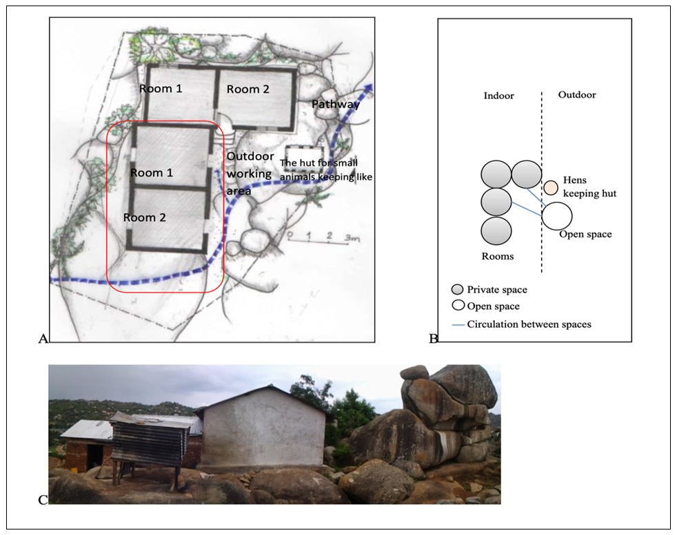 | Figure 4.12. A, B and C: L-Shape house type, the circled in the house plan is new part of the house as it can be seen in the image above the structure with burnt bricks without plaster. Author’s fieldwork study 2025 |
4.5. Roof Types
Throughout the study, different roof types were identified, documented and analysed. The development of different roof types around the study area may have been influenced by difference in resources, Climate or social-cultural factors. The most wide spread roof types are pitched roof or gable roof, hipped roofs and mono-pitched roof as illustrated in figure 4:13 A:
4.5.1. Gable Roof
This type consists two sloping sides that meet at the ridge and terminate at the gable end. This was found throughout the study area to be the common type of roofing style. In the study area, gable roofs were observed in many houses and most of them are low pitched. Gable roof has an advantage of being relatively simple and economical to build as they are very sturdy in design. Also, because it is sloped fairly steeply, it provides excellent water drainage, leading to fewer leaks and a longer life of the roof.
4.5.2. Hipped Roof
This type is characterized by a plane that slopes down in all sides of the eave and all walls of the building which is of the same height. The observation from the site study revealed that there are some houses which have been roofed by this style though the number is small compared to gable roof. The construction of hip roof seems to be complex and expensive.
4.5.3. Mono Pitch
This type of roofing consists of only one plane that slopes down to the eave. This is most common roofing style. Its construction is very simple, does not need a very experienced carpenter to construct this kind of roof and uses minimum amount of materials and it is easy to adapt the changes for new style. 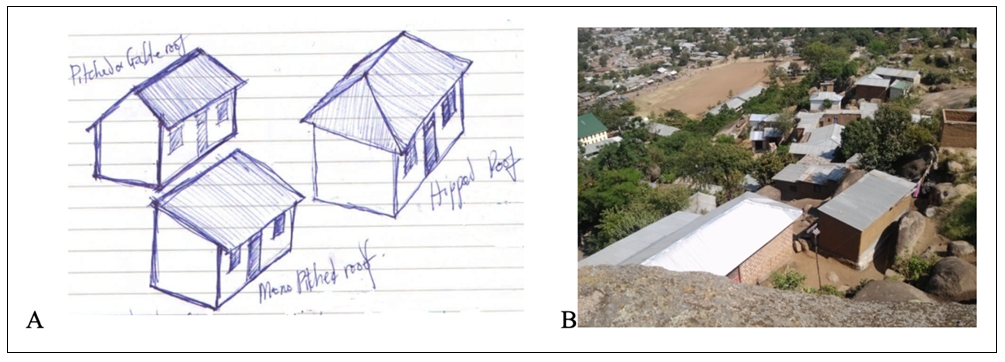 | Figure 4.13. A and B Different roofs types (Mono pitch, gable and hipped roof). Author’s fieldwork study 2025 |
4.6. Design and Construction of Dwelling House
4.6.1. Artisans and Professionals Contribution in Informal Housing Development
Most respondents used Local Artisans (Mafundi) to design and build their houses. The study has shown that, about 23 respondents used Artisans (Mafundi) from the designing stage to the construction stage. In this regard, Artisans played great role in designing and constructing buildings in rocky and steep slope terrain areas. Most of houses are single storey building, the design and construction of which Artisans had accumulated extensive knowledge and they knew construction methods and techniques that would cut down costs. Most respondent seemed to have confidence Artisan would meet their designing and construction needs. Transformed into L-shape house type. 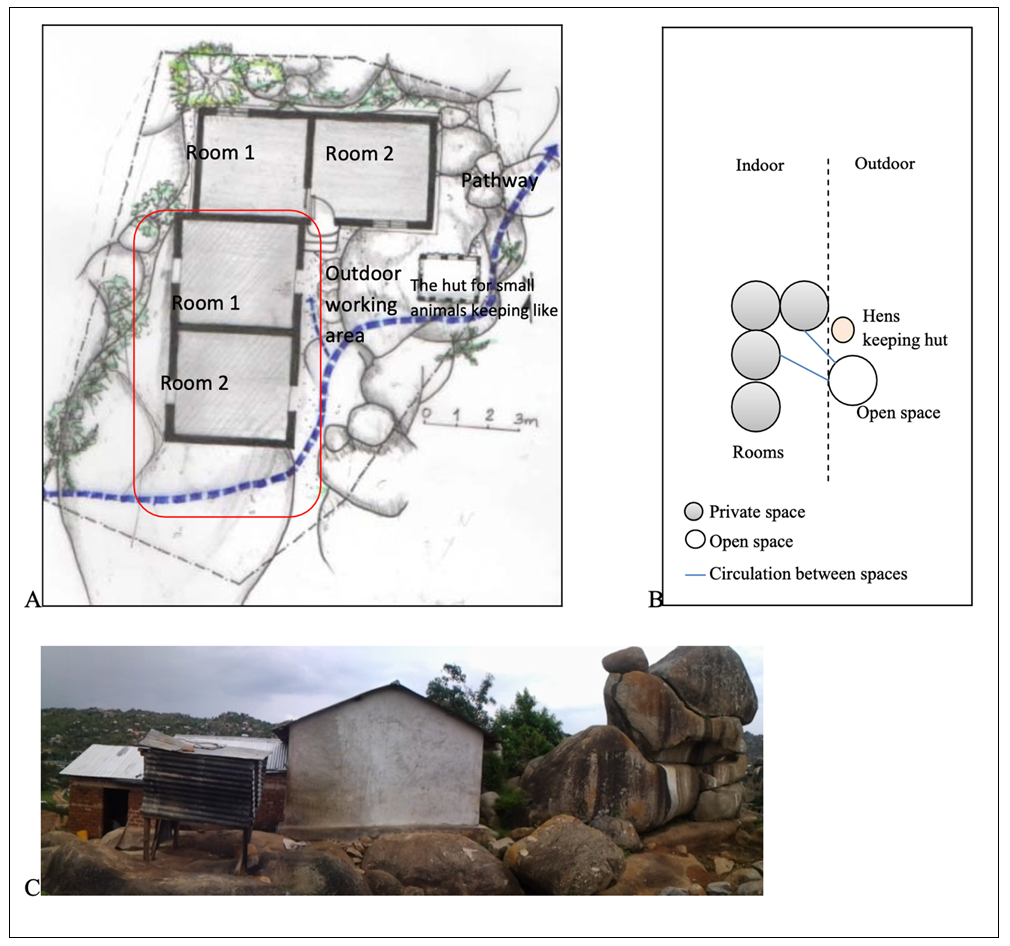 | Figure 4.14. A, B and C: L-Shape house type, the circled in the house plan is new part of the house as it can be seen in the image above the structure with burnt bricks without plaster. Author’s fieldwork study 2025 |
4.7. Space Use and Construction Practices
Spaces are categorized as private, semi-private, and semi-public. Outdoor spaces play a crucial role in daily life, compensating for limited indoor areas. Construction materials include burnt bricks, sand-cement blocks, mud, and wattle, reflecting affordability and local familiarity. Incremental construction allows households to adapt their dwellings over time.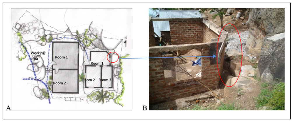 | Figure 4.15. A and B: Wall of house adapted/ to the undulated rock for the new building. Author’s fieldwork study 2025 |
4.8. Determinants of House Form
House form is primarily determined by slope, rock distribution, and plot geometry. Rocks are selectively retained or removed to define clusters, circulation, and spatial hierarchy. These physical constraints produce organic settlement patterns that evolve incrementally.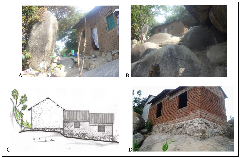 | Figure 4.16. A, B, C., and D: Some elements that generate the house form; these components include walling, openings, foundation, and roofing. Author’s fieldwork study 2025 |
5. Key Findings, Conclusions, and Recommendations
5.1. Key Findings
This study analyzed housing typologies in informal settlements located on rocky hills in Mabatini and Nyambiti C, Mwanza City. The findings show that house forms, spatial organization, and construction practices are strongly shaped by topographic constraints and household socio-economic conditions. Housing solutions are predominantly incremental, terrain-responsive, and functionally adaptive.
5.1.1. House Type Classification Criteria
House types were classified based on spatial organization, including form and shape, plan layout, orientation, number of rooms, and space use, with limited consideration of plot characteristics and construction materials. Typology was employed [20] as an analytical tool to systematically examine and compare residential forms. Key variables such as room count, layout configuration, and spatial hierarchy were adapted from established typological frameworks and modified to suit the rocky hill settlement context.
5.1.2. Identified House Types
Eight house types were identified: terrain-adaptive, rooms-in-line, I-shape, grouped, T-shape, one-room, U-shape, and L-shape. Most typologies are defined by plan form and spatial arrangement, while the terrain-adaptive type is primarily shaped by landform conditions. The naming of house types facilitated differentiation and comparative analysis by emphasizing spatial configuration rather than function.
5.1.3. Space and Space Use
Space use in rocky informal settlements is characterized by a strong reliance on outdoor areas. Spaces were categorized as private, semi-private, and public. Interior spaces function mainly as private domains, while exterior areas adjacent to dwellings support domestic and social activities. Despite limited enclosure and irregular terrain, a clear spatial hierarchy exists, with intermediate outdoor spaces playing a critical role in accommodating daily household functions.
5.1.4. Construction Materials and Techniques
Burnt clay bricks are the predominant construction material, typically used with mud mortar, adobe, or wattle-and-daub techniques. Sand–cement blocks were observed in a limited number of cases. The widespread use of burnt bricks is attributed to affordability, local availability, and low transportation costs, making them suitable for low-income households.
5.1.5. House Types and Incremental Transformation
House typologies in Mabatini and Nyambiti C are not static but evolve through incremental extensions driven by changing household needs and unstable income flows. Most dwellings begin as one- or two-room units and expand over time, often resulting in hybrid forms such as L- or U-shaped houses. Incremental construction reflects both economic uncertainty and household participation in the building process.
5.1.6. Spatial Organization and Topographic Constraints
Steep slopes, exposed rocks, and irregular plot shapes significantly limit buildable space. Plots are generally small, unfenced, and defined by informal boundaries that follow the natural terrain. Open spaces primarily facilitate circulation and support outdoor domestic activities, which are integral to everyday life in the settlement.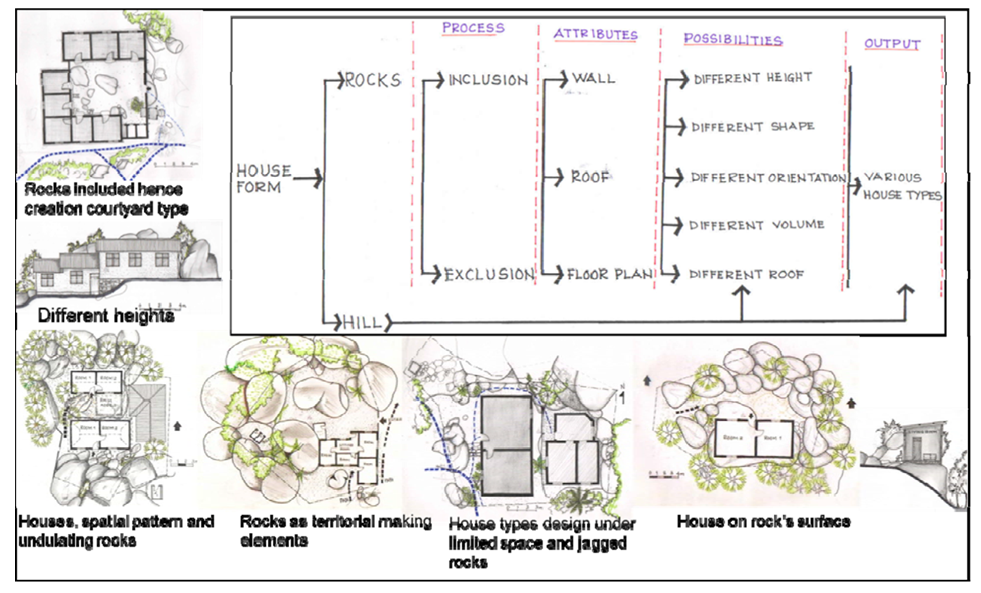 | Figure 5.1 |
5.1.7. House Design under Rocky Hill Conditions
House design in rocky hill settlements requires negotiation with jagged rock formations through leveling, cutting, and partial rock removal. These processes are labor-intensive and influence building orientation, layout, and typology [20]. Topography is therefore a key determinant of house form and spatial configuration.
5.1.8. Settlement Pattern and Rocky Landscape
Informal settlements in Mwanza’s rocky hills exhibit organic and fragmented spatial patterns shaped by topography rather than formal planning principles. Housing layouts lack geometric order and visual uniformity, reflecting incremental development processes and direct adaptation to the undulating landscape.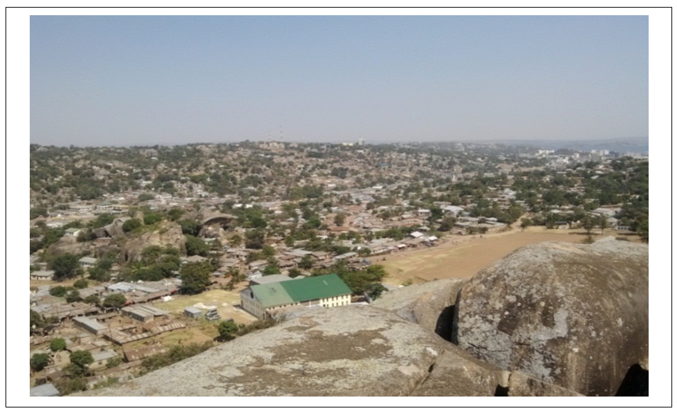 | Figure 5.2. Mabatini and Nyambiti C, Mwanza City, Tanzania [E.A] |
5.2. Conclusion
This study demonstrates that informal settlements on the rocky hills of Mwanza City are characterized by coherent spatial organization, adaptive building practices, and strong responsiveness to both topographic constraints and household socio-economic conditions. Contrary to prevailing perceptions of informality as spatially chaotic, the findings reveal a systematic production of housing forms shaped by incremental development, terrain negotiation, and everyday domestic requirements.House typologies identified in Mabatini and Nyambiti C reflect indigenous architectural knowledge embedded in self-built processes. Flexible layouts, hierarchical spatial arrangements, informal boundary formation, and the extensive use of shared outdoor spaces collectively enable households to transform physically constrained rocky landscapes into functional and livable residential environments [28]. These characteristics indicate that informality in rocky hill contexts operates as an adaptive design system rather than a failure of planning.The construction strategies observed the use of locally available materials, familiar techniques, and phased expansion that highlight affordability and future adaptability as central drivers of housing production. Such practices provide important insights into the priorities and aspirations of low-income households and underscore the relevance of resident-led solutions in meeting housing needs under constrained conditions.From a policy and design perspective, the study emphasizes the need for housing improvement programmes that recognize existing spatial logic, incremental growth patterns, and terrain-responsive design strategies. Establishing context-sensitive quality thresholds, rather than imposing standardized formal models, is essential for achieving socially and environmentally sustainable interventions in Rocky Hill informal settlements [20].
5.3. Recommendations
5.3.1. Adoption of Participatory Design Approaches
The study reveals that housing in Rocky Hill informal settlements is largely produced without formal architectural drawings. Local artisans play a central role by advising homeowners on building orientation, room number, size, and layout based on site conditions and practical experience. Design decisions typically emerge through consensus between artisans and homeowners, combining contextual knowledge of the built environment with lived construction experience.Participatory design should therefore be recognized as a knowledge-sharing and learning process rather than a formalization of homeowners as designers. Professionals are encouraged to integrate residents’ needs, expectations, and spatial practices into design decision-making. Meaningful participation may occur through dialogue, experiential exchange, negotiation, and observation of everyday spatial behavior, thereby positioning homeowners as active members of the design process.
5.3.2. Planning Interventions for External Spaces
The study identifies external space as a critical area requiring planning support. In many cases, residual spaces between dwellings are poorly defined, underutilized, and prone to waste accumulation. Well-planned outdoor living areas are needed to support social interaction, children’s play, and household activities while remaining manageable and hygienic [28].Planners can contribute by facilitating the formation of protected shared spaces, such as communal courtyards, which enhance collective responsibility and spatial ownership. This may involve selective rock removal to improve accessibility and create usable common areas. In addition, consolidating fragmented residual spaces through infill development can improve spatial efficiency. With appropriate upgrading, Rocky Hill settlements also present opportunities for landscape integration and panoramic viewpoints, which may contribute to local economic activities such as tourism.
5.3.3. Integration of Geological Assessments
Rocky hill settlements are characterized by large rock formations, some of which pose perceived or actual safety risks. While rock falls are rare, excavation activities at the base of rock formations can compromise stability and increase hazards. It is therefore recommended that communities, in collaboration with relevant government agencies, undertake basic geological assessments to identify unstable formations and implement appropriate risk mitigation measures [3]. Such interventions are essential for improving safety without undermining settlement continuity.
5.3.4. Review of Planning and Building Regulations
Current planning and building regulations often fail to accommodate the economic realities, construction practices, and spatial constraints of informal settlements in rocky hill contexts. If housing policy is to support the right to adequate shelter, regulatory frameworks must be flexible enough to reflect local materials, skills, construction methods, and site conditions.It is recommended that affordable, realistic, and context-responsive standards be developed for informal settlements. Regulations should allow adaptable plot use, flexible spatial standards, and incremental construction. For example, conventional setback requirements may be impractical in rocky hill settlements and should be revised to reflect on-site realities.In addition, systematic evaluation of locally available construction materials and technologies should be undertaken to enhance performance while maintaining affordability. The strategic integration of local and selectively imported materials can support environmentally responsive and cost-effective housing improvement.
5.3.5. Engagement of Architects, Planners, and Local Authorities
The classification of house types provides a valuable basis for improving housing design in alignment with socio-economic conditions and topographic constraints. However, housing development in Rocky Hill’s informal settlements remains largely detached from professional input, often resulting in suboptimal living conditions.Architects and planners are encouraged to engage informally yet constructively in housing development and upgrading processes. Professional support should focus on flexible design solutions, material optimization, and technical guidance tailored to residents’ financial and skill capacities. Reducing social and professional distance between architects, planners, and artisanal builders is essential for effective collaboration.Local authorities and relevant ministries should play an enabling role by supporting technical assistance, land access strategies, and incremental upgrading initiatives. Professional involvement in informal housing should aim to enhance safety, functionality, and environmental responsiveness while respecting residents’ adaptive practices and socio-economic realities.
Study Limitations and Future Research
This study was limited to two informal settlements and a sample of twenty-five housing units within Mwanza City. While the findings provide important insights into terrain-responsive housing typologies, broader comparative studies across different geological and socio-economic contexts are necessary to strengthen generalizability. Future research may further examine incremental housing transformation over time, resident mobility patterns, and the long-term environmental implications of settlement development on rocky hill landscapes.
ACKNOWLEDGEMENTS
The author gratefully acknowledges the support and cooperation of local leaders, artisans, and residents of Mabatini and Nyambiti C, whose insights and experiences made this study possible.
References
| [1] | Acioly, C., & Davidson, F. (1996). Density in urban development. Building Issues, 8(3). Lund Centre for Habitat Studies, Lund University. |
| [2] | Amatunga, D., Baldry, D., Sarshar, M., & Newton, R. (2002). Quantitative and qualitative research in the built environment: Application of mixed research approaches. Work Study, 51(1), 17–31. |
| [3] | Cadstedt, J. (2006). Influence and invisibility: Tenants in housing provision in Mwanza City, Tanzania (Doctoral dissertation). Stockholm University. |
| [4] | Crowe, S., Cresswell, K., Robertson, A., Huby, G., Avery, A., & Aziz, S. A. (2011). The case study approach. BMC Medical Research Methodology, 11, Article 100. https://doi.org/10.1186/1471-2288-11-100. |
| [5] | Denscombe, M. (2007). The good research guide for small-scale social research projects (3rd ed.). Open University Press. |
| [6] | Duerk, D. P. (1993). Architectural programming: Information management for design. John Wiley & Sons. |
| [7] | Ejigu, A. (2011). Coupling informality with formality: Ideas for innovative housing and urban development strategies. In Proceedings of the 4th European Conference on African Studies. Royal Institute of Technology, Stockholm. |
| [8] | Gren, A. M. (2006). Exploring typologies, densities and spatial qualities: The case of low-income housing in South Africa (Unpublished doctoral dissertation). Royal Institute of Technology, Stockholm. |
| [9] | Guney, Y. I. (2007). Type and typology in architectural discourse. Balikesir University Journal, 9(1), 3–18. |
| [10] | Habraken, J. N. (1988). Type as a social agreement. In Proceedings of the Asian Congress of Architects. Seoul. |
| [11] | Kachenje, Y. (2005). Home-based enterprises in informal settlements of Dar es Salaam, Tanzania (Unpublished master’s thesis). Royal Institute of Technology, Stockholm. |
| [12] | Kellett, P. (2011). Contemporary vernaculars: Informal housing processes and vernacular theory. Journal of the International Society for the Study of Vernacular Settlements, 2(1), 1–12. |
| [13] | Kombe, W. J., & Kreibich, V. (2000). Informal land management in Tanzania (SPRING Research Series No. 29). University of Dortmund. |
| [14] | Kothari, C. R. (2004). Research methodology: Methods and techniques (2nd ed.). New Age International. |
| [15] | Lawrence, R. J. (1994). Type as an analytical tool: Reinterpretation and application. In K. A. Franck & L. Schneekloth (Eds.), Ordering space: Types in architecture and design (pp. 27–45). Van Nostrand Reinhold. |
| [16] | Lupala, J. (2002). Urban types in rapidly urbanising cities: Analysis of formal and informal settlements in Dar es Salaam, Tanzania (Doctoral dissertation). Royal Institute of Technology, Stockholm. |
| [17] | Miles, M. B., & Huberman, A. M. (1994). Qualitative data analysis: An expanded sourcebook (2nd ed.). SAGE Publications. |
| [18] | Ministry of Lands, Housing and Human Settlements Development. (2009). Environmental impact assessment of the formalization of unplanned urban settlements in Mwanza City. Government of Tanzania. |
| [19] | Ministry of Lands, Housing and Human Settlements Development. (2012). National programme for regularisation and prevention of unplanned settlements (2012–2021). Government of Tanzania. |
| [20] | Mwanza Urban Water and Sewerage Authority. (2013). Environmental and social impact assessment report for Mwanza City. Government of Tanzania. |
| [21] | Nguluma, H. M. (2003). Housing themselves: Transformations, modernisation and spatial qualities in informal settlements in Dar es Salaam, Tanzania (Doctoral dissertation). Royal Institute of Technology, Stockholm. |
| [22] | Nnaggenda-Mussana, A. (2004). Sprawl and the city: House types in formal and informal settlements of Kampala (Licentiate thesis). Royal Institute of Technology & Makerere University. |
| [23] | Nnaggenda-Mussana, A. (2008). Housing clusters for densification within upgrading strategies (Doctoral dissertation). Royal Institute of Technology & Makerere University. |
| [24] | Nnaggenda-Mussana, A., & Vestro, D. K. (2013). Upgrading with densification: Learning from Kampala, Uganda. Global Journal of Engineering, Design and Technology, 2(1), 27–72. |
| [25] | Patton, M. Q. (2002). Qualitative research and evaluation methods (3rd ed.). SAGE Publications. |
| [26] | Seleki, B. (2001). Urban housing problems in Tanzania: Possible policy interventions. Lund University. |
| [27] | Tellis, W. (1997). Application of a case study methodology. The Qualitative Report, 3(3). |
| [28] | UN-Habitat. (2003). The challenge of slums: Global report on human settlements. Earthscan. |
| [29] | Yin, R. K. (1994). Case Study Research: Design and Methods. London: Sage Publications. |
| [30] | Yin, R. K. (2009). Case study research: Design and methods (4th ed.). SAGE Publications. |


 Abstract
 Reference
 Full-Text PDF
 Full-text HTML