Hussein Hammadi Alfarhani1, Bahar Başer Kalyon Cuoğlu2
1Department of Architecture, Istanbul Okan University, Istanbul, Turkey
2Department of Urban Design & Landscape Architecture, Istanbul Medipol University, Istanbul, Turkey
Correspondence to: Hussein Hammadi Alfarhani, Department of Architecture, Istanbul Okan University, Istanbul, Turkey.
| Email: |  |
Copyright © 2023 The Author(s). Published by Scientific & Academic Publishing.
This work is licensed under the Creative Commons Attribution International License (CC BY).
http://creativecommons.org/licenses/by/4.0/

Abstract
In the recent decade, Baghdad has drawn into dramatic socio-economic transformations along with rapid urban development as a result of the economic recovery, including an oil boom, this has had a significant impact on the development patterns that have been adopted, where the physical and social patterns and typologies of new residential areas have turned from global experiences and international style within Iraqi urban context. As a result, many mass housing or gated communities with different designs have been shaped and constructed particularly in Baghdad without taking into account local consideration, causing the loss of a significant degree of the heritage and urban traditional fabric. This study tries to compare and analyze two urban patterns within the city of Baghdad and its surrounding (neighborhood scale); Alkhadimyah, a traditional urban pattern; BNT (Bismayah new town) the suburban district of Baghdad. The comparison depends on social and spatial analysis, firstly; Kevin Lynch's method of “The image of the city 1960” is used for examining the planning strategies and urban design elements, in terms of the physical spaces, such as buildings, roads, open spaces, and public facilities, to understand holistic insights about their complex relations. Secondly; this study used a questionnaire, which was analyzed using SPSS 22.0 to record participant responses. The questionnaire survey technique is used to collect data on residents’ perceptions, preferences, and interpretations of cases built environment. The findings of the analysis demonstrate significant differences between the spatial organization and social structure of both cases, this paves the way in the future for vital indicators to prepare a new set of design guidelines for new developments areas that will enhance the socio-spatial planning, urban design features of urban spaces and contribute in improving the image of Baghdad city and its landmarks, thus enhancing a sense of identity of the city and quality of life to Baghdad residents.
Keywords:
Socio-spatial analysis, Urban Image Baghdad, Kevin Lynch
Cite this paper: Hussein Hammadi Alfarhani, Bahar Başer Kalyon Cuoğlu, A Socio-Spatial Comparison Analysis of Two Existing Neighborhood Planning in Baghdad, Architecture Research, Vol. 13 No. 1, 2023, pp. 1-11. doi: 10.5923/j.arch.20231301.01.
1. Introduction
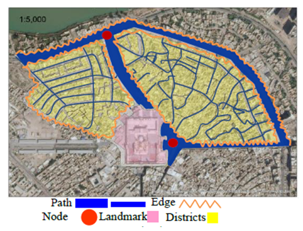
Many studies of urban spaces, including those by Kevin Lynch (1960), Edward Robbins and Rodolphe El-Khoury (2015), and Jane Jacobs (1961), philosophically and empirically divide the city into two fundamental categories. The first is the physical city, which contains and shapes the open space system between buildings. The second is the social city, which includes all of the city's social activities. Urban studies investigations seek to capture and analyze the interplay between the social and the physical in the overall city (Hillier and Hanson, 1984). In his book The Image of the City, Kevin Lynch introduced the term "City Image" which he defined as a result of a two-way process between the observer and his environment, the environment suggests distinctions and relations, and the observer-with great adaptability and in the light of his purpose-selects, organizes, and endows with meaning what he sees (Lynch 1960, p. 6). The ability of the observer to adopt is influenced by his perception and interactions with the environment. By maintaining the beautiful and significant features of the city in mind, the perception shapes and impacts the observer's mental image (Atik, akir, & Benian, 2009). The physical, social, cultural, and historical values of a city create an impression in the minds of its residents, shaping the city's identity. Identity is defined by Lynch (1981) as "the extent to which a person can recognize or recall a place as being distinct from other places." Cities, like people, should have character and distinctiveness, this character is comprised of several distinguishing features or recognizable aspects. Kevin Lynch developed his theory of city image through a five-year examination of three American cities: Boston, New Jersey, and Los Angeles. Path, edge, district, node, and landmark are the five components of a city's image that he recognized, but in actuality, they are all interconnected and cannot exist separately since "districts are structured with nodes, defined by edges, penetrated by paths, and sprinkled with landmarks" (Lynch, 1960, p. 49).Lynch reported that users understood their surroundings in consistent and predictable ways, forming mental maps with five elements: paths, the streets, sidewalks, trails, and other channels in which people travel; Edges, perceived boundaries such as walls, buildings, and shorelines; Districts, relatively large sections of the city distinguished by some identity or character; nodes, focal points, intersections or loci; Landmarks, readily identifiable objects which serve as external reference points. Lynch considered these five elements to be the most legible components in the urban environment that overcome individual distinctions, (Figure 1).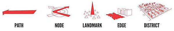 | Figure 1. The urban image elements of physical environment (Lynch, 1960) |
The rapid changes came along with modern planning systems which have influenced architectural and planning standards in Arabic cities, favoring the international style and its connection to industrial and technical progress (Al Silq, 2011; Al-Ahbabi & Neama, 2011). As a result, local urban and architectural forms that had evolved to meet people's physical and cultural requirements were completely ignored (Behsh, 1993). One of the most common criticisms of modernism in architecture is its disrespect for inherited cultural, social, and environmental aspects (Bianca, 2000). The rejection of the traditional organic design in favor of the benefits of the gridiron layout in modern urban planning is an example of this. Furthermore, it is critical to note that current design components have been introduced without regard for their suitability, aesthetic satisfaction, or capacity to mix in with the surroundings (Eben Saleh, 1997). These changes in a city's image may result in a loss of local identity and the city's ability to differentiate itself from others.After 2003, the pressures of wars and political issues on one side, and huge concentrations of population, the dominance of vehicular movement, and inappropriate urban planning approaches on the other have led Baghdad city into dramatic socio-ecological and cultural transformations with rapid urban development, both the physical and social patterns of the residential neighborhoods being shaped or transformed as mass housing or gated communities with different demographic. As a result, the traditional architecture and its design patterns have dramatically changed, for instance, the traditional architecture of Baghdadi houses (Figure 2), has lost the shanasheel's distinguishing features.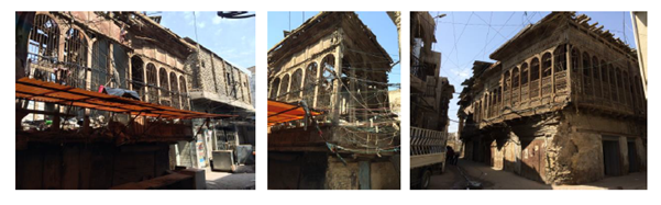 | Figure 2. Baghdadi house characteristics (Susa, 1952) |
Local urban and architectural forms that had evolved to meet people's physical and cultural requirements were completely ignored (Behsh, 1993). These changes in a city's image may result in a loss of local identity and the city's ability to differentiate itself from others. Baghdad has had several eras of development, including pre-colonial, colonial, independent, and most recently urbanization. Concerns over identity and cultural representation have been expressed at all phases, but notably in recent years as Baghdad has worked to maintain its unique identity, culture, and customs. This research will analyze the spatial configurations and social structures of two urban patterns within the city of Baghdad and its surrounding, the capital of Iraq, these include Al khadimyah, the traditional urban pattern of the city with remarkable remains of architectural, historical and cultural heritage; Bismayah new town (BNT) the suburban district of the city which is developed close to the periphery of Baghdad in 2014, through the Kevin Lynch's method of “The image of the city 1960” and questionnaire survey. After analyzing two cases, we will answer the basic question of this research: How are the two neighborhoods similar or different to each other in terms of spatial configurations & social structures in Baghdad? This can guide the future development of new sustainable neighborhood planning in Iraq, to create new residential neighborhoods with new urban environments that are more livable, organized, and attractive.
2. Study Area Characteristics
Baghdad is the Iraqi capital, it is the second most populous Arab city after Cairo, Egypt, located along the Tigris River, and 50km from the Euphrates with a total area of 4,555 km2 (Ihsan Fethi, 1977). Baghdad divides into two parts: Karkh on the west coast of the Tigris River and Rusafa on the eastern coast of the Tigris. It has about 70 neighborhoods and 9 administrative districts. These districts represent the main sectors of the city. Baghdad is one of the cities created after Islam, which has been a cultural, historical, and social hub for Arab and Islamic civilization since it was the capital of the Islamic empire in A.D. 762, built by Abu Ja‟afar Al Mansour (Gulick, 1976; Kotapish, 2000; Negoita, 2011). The location of Baghdad and Iraq locates in the Middle East, south-west of the Asian continent, and it shares borders with Syria to the northwest, Jordan to the west, Saudi Arabia and Kuwait to the south, Iran to the east, and Turkey to the north. Iraq has a narrow section of coastline measuring 58 km (35 miles) between Umm Qasr and Al Faw on the Arabian Gulf. It is, therefore, considered one of the Arabic Gulf countries. A total land area is 438,446 km² in Iraq’s latitude & longitude is 33°14,'N 44°14'E, (UN-Habitat, 2005) (Figure 3).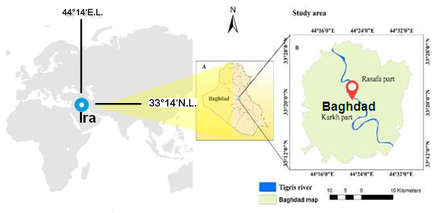 | Figure 3. The location of Iraq and its capital, Baghdad (UN-habitat, 2005) |
The first case study in this research is the traditional quarter (mahallah) in Baghdad, The Al Kadhimiya historical site (Figure 4), consists of four nearby high-density residential neighborhoods: Shiyoukh (the largest), Al Tell (Study area), Dabagh Khana, and Qatana,. the southern and northeastern mahallas seem to be its oldest parts, important markets like Astarabadi Suq, and many large commercial storage buildings or khans (Polservice,1974). The site is made of several small mosques, schools, stores, public baths, workshops, and historic and modern hotels. The houses include shanasheel (wooden chambers on the upper level that extend to the street), which gives the building a great sense of privacy. It also acts as an honor and prevents sunlight from entering, as well as providing shade for people walking in the streets. The urban tissue of the Al Alkahdimiyah Neighborhoods, like many other traditional Iraqi cities, is dense and compact a low-rise, high-density horizontal development; houses are close together, in a compact urban tissue, with courtyards for each unit (Al-Rahmami, 1986).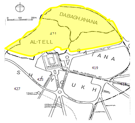 | Figure 4. Al Kadhimiya historical site(mahallas) (Al-Dujaili, 2010) |
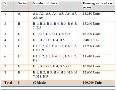
The second case study is Bismayah New Town (BNT); it is the first and biggest development project in the history of Iraq, under construction till now. BNT suggested under Baghdad Comprehensive Development Plan until 2030 (BCDP 2030). BCDP suggested planning new cities with different sizes and destinations around Baghdad, with a railway to connect Baghdad to these new cities. Bismayah locates 10km southeast of Baghdad, spread over a total area of 1,830 Hectarearea, which is planned to accommodate around 600,000 occupants in a total of 100,000 residential units. The new city of Bismayah consists of eight integrated residential districts (A-H). Each residential area has five to nine complexes consisting of many residential buildings. The total housing units of the project are 100,000 units, considered the largest housing project in Iraq (Figure 5).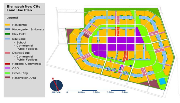 | Figure 5. Bismayah New City Land Use Plan (NIC, 2012) |
3. Research Methodology
The methodological study consists of a comparative analysis of the urban image of both cases within Baghdad city and its surrounding, the capital of Iraq. These include the Al-Tell neighborhood/ Alkhadimyah, the traditional urban pattern of the city with remarkable remains of architectural, historical, and cultural heritage; BNT (Bismayah new town), the suburban district of the city, is developed close to the periphery of Baghdad in 2014, (10 km from Baghdad) (Figure 6 and Figure 7). The neighborhoods analyzed depend on social and spatial analysis. Firstly, the method of Kevin Lynch used for examining the urban images. Secondly, this study used a questionnaire to record participant responses of residents’ perceptions, preferences, and interpretation of cases built environment analyzed with frequency analysis using SPSS.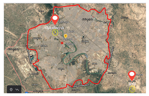 | Figure 6. Case Studies Locations in Baghdad and it’s Surround |
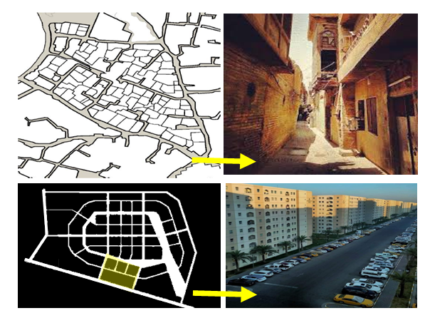 | Figure 7. Urban patterns of Alkhadimyah (Top) and BNT (Bottom) (Author, 2022) |
3.1. Urban Image Analysis
Comparative case studies involved the five elements of an urban image in the traditional settlement of Alkhadimyah with the modern settlement (BNT). The observations were carried out using several phases. These phases are: (1) visit the site, (2) take notes, (3) draw sketches for details (character, the urban fabric, and the urban image), (4) Take photos or a video of the places that have identified to make the comparison among them and uncover the changes in the urban image elements. (5) Test the concept of legibility “the ease with which its parts can be recognized” Lynch 1960, to explore the inhabitants’ image of the urban environment, the main urban elements: paths, edges, districts, nodes & landmarks using a questionnaire to know perceptional picture for the residents which result from the difference of the legibility degree in an urban environment and indicating the landmarks in the city. Among questions, people were asked to name and describe what they thought were the most distinctive & recognizable elements of the city and point them to extract the most important urban elements. After the data gathering, it was analyzed using SPSS 22.0, then the results were evaluated to verify which urban layouts of cases would show the highest legibility. The urban image method was applied to Alkhadimyah as following:- Path: The Al Kadhimiya historical site was originally 91 hectares in size. According to Warner (2006), this area had a population of over 40,000 people. As a result, the population density is approximately 430 people per hectare. The city of Alkhadimyah is a prominent urban focus in Baghdad due to its cultural and religious significance. The urban spaces, including streets within the Arab-Islamic cities, are seen as a critical component in the creation of an urban image. As Lynch described paths as channels for potential movement along which the observer customarily, occasionally, or potentially moves and as channels that link the city’s visual experience with the movement, Alkhadimyah is a compact hierarchy of narrow, winding streets that contribute to the city’s aesthetics. Minor streets were very narrow (2–3 m), whereas Bab Al-Qiblah Street and Bab Al-Mourad Street are the significant streets in Alkhadhimiya (Figure 8).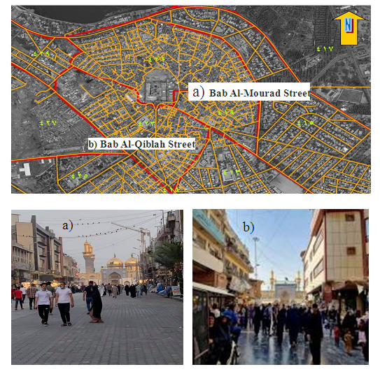 | Figure 8. Bab AL_Mourad Street & Bab Al_Qiblah Street (Author, 2022) |
These roads were designed to connect the historic fabrics with the city-wide modern street networks in the transitional and new urbanized areas and are characterized by long, straight, and wider streets while roads and alleyways are narrow and organic zigzag patterns with cul-de-sacs, mostly shaded (Al-Kaissi, 1984) (Figure 9), many of these roads are dead-ends, which allows residents to keep an eye on their surroundings. Furthermore, dead-ends create semi-public or semi-private spaces where children can play under the watchful eye of their mothers while maintaining the social privacy required in an Arab Muslim community. Despite their narrowness, traditional alleyways create a comfortable setting for social interaction by allowing pedestrian circulation and all that it involves. In general, the width of the roadways was suitable for their purposes and functions (Mahgoub, 2007).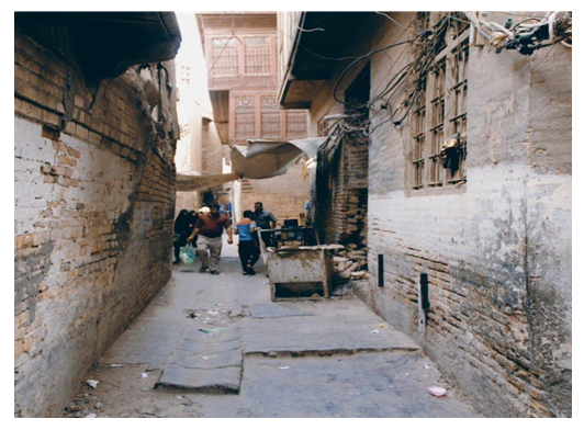 | Figure 9. Roads and alleyways in AlKadhimiyah (Author, 2022) |
Depending on the results of the questionnaire survey, the streets most frequently mentioned, had the most connection to the other streets, thus the strong linkage of neighborhood to its immediate surroundings, the streets Bab Al-Qiblah (56 frequencies), Bab Al-Mourad (50 frequencies) and Abd al-Muhsin Streets (33 frequencies) were in Alkhadimyah, due to their location in the heart of the city, in addition totheir religious and historical significance.Node: According to Lynch's definition, can be primaryjunctions, points of a break in transportation, crossings or convergences of paths, moments of transition from one structure to another, or simply defined as concentrations that gain their importance from the condensation of some use or physical characteristics, such as street-corner hangouts or enclosed squares, two types of nodes easily identified in Al-Kadhimiya, those at major intersections such as Jawadin (Plazas) and other social nodes (Figure 10).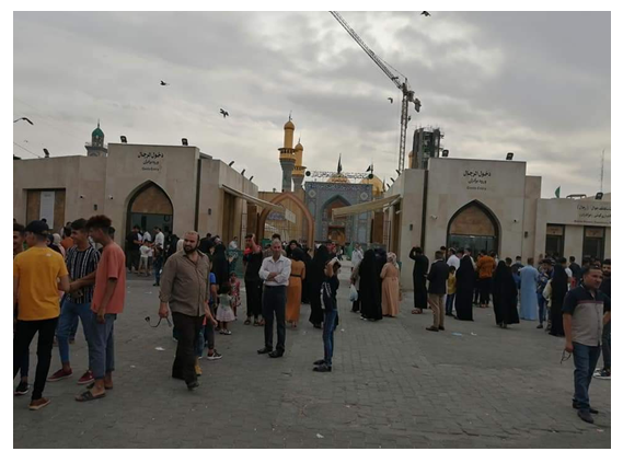 | Figure 10. One of the nodes of Alkahdimyah, Jawadin (Author, 2022) |
Depending on the results of the questionnaire survey, The participants demonstrated the most frequent squares and intersections as important nodes were Jawadin (45 frequencies), Alzahra (28 frequencies), Al-Jawahiri (25 frequencies), and Adan squares (10frequencies) in Alkhadimyah, these nodes had special importance to the residents.Districts: Al Kadhimiya historical site consists of four nearby high-density residential neighborhoods: Shiyoukh (the largest), Tell, Dabagh Khana, and Qatana. The southern and northeastern mahallas seemed to be their oldest parts (Figure 4). Residential areas are the major areas in these neighborhoods. There is one type of residential area district; traditional houses and narrow, short streets at north and the eastern parts. Important markets like Astarabadi Suq and many commercial storage buildings or khans located along the main road in the east and western part could consider districts since they attract a heavy movement of people and vehicles (Figure 11). 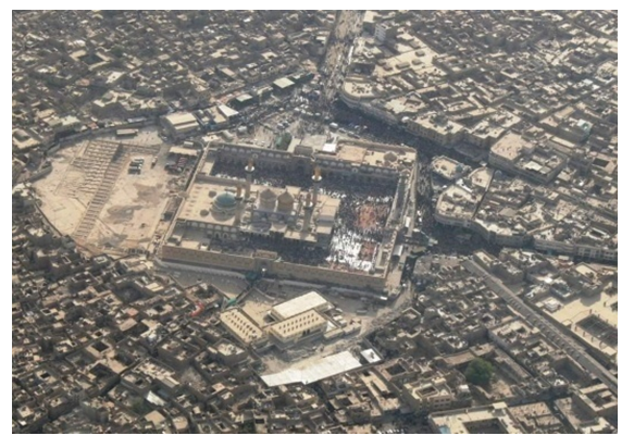 | Figure 11. High-density residential neighborhoods in AlKadhimiyah |
Edges: As Lynch points out are visually prominent, have a continuous form, and are impenetrable to cross movement. They are considered district boundaries or paths, and they frequently represent edges. As a result, Alkhadimya in the morphological composition consists of four mahallas, including Al--Tell, Qattana, Dabagh—khana, and shiyoukh. Bab Al-Mourad Street, Bab Al-Qiblah Street, Bab Al-Darwaza Street, Quraish Street, Al-Zahra' Street, and Al-Imam Al-Kadhim Street are the most important streets in Alkadhimiya, edges are considered to be linear elements, which constitute boundaries in an environment. Besides the main streets that divided the city into different sectors, there was an edge that appeared as a result of changing the land use – mostly from residential to commercial. The interior edges divided the area into secondary sectors such as streets, alleys, the remains of (Shanasheel) or balconies, and hierarchy spaces distinguished the area and gave it its local identity (Figure 12).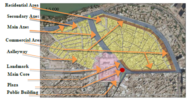 | Figure 12. The basic urban structure as edges of Alkhadimyah (Author, 2022) |
Landmark: can be any prominent object that acts as a reference point, which includes the other four elements defined by Lynch. If a node, a path, an edge, or a district is sufficiently salient they could be recognized as landmarks. For example, a very busy street or node can be a landmark known by all citizens of an area. In the city of Kadhimiya, the shrine (Figure 13), with its geometrical form represents an important element in uniting traditional quarters as a strong landmark. It reflects the place that can be used by the public under any circumstances. This core reveals its focus on the concept of the center and its role in the integration of the currents of life. The public space of the center was wrapped by a group of public buildings, markets, and owners of trade and industry as well as an integrated network of alleys. The Shrine Mosque has special importance to people in Alkhadimyah, due to its location in the heart of the old city, and its historical and religious importance, also it is considered the main gathering place in the city that attracted people, the Abd al-Muhsin Al- Saadoun monument (40 frequencies) and Mashrabiya Building (36 frequencies) were other landmarks mentioned.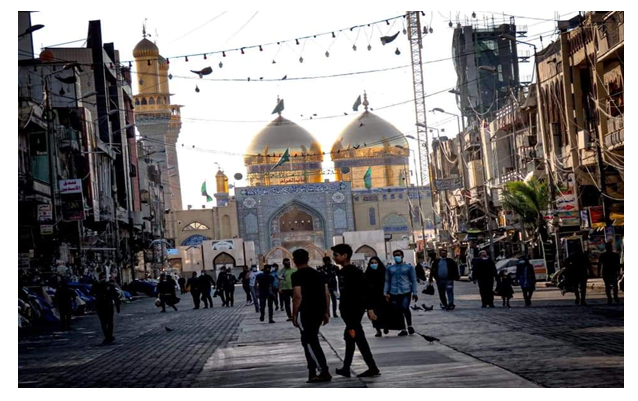 | Figure 13. Landmark of Alkahdimyah |
 | Figure 14. The basic urban structure as edges of Alkhadimyah (Author, 2022) |
The urban image method was applied to Bismayah as follows:-Path: BNT is a modern city designed at the turn of the twenty-first century to meet current needs, the streets are laid out in a gridiron street system and impose themselves at the expense of buildings, new roads are wide and long in comparison with traditional ones; which met the modern transportation and engineering standards of street widths, travel lanes, automobile parking lots, sidewalks, building setbacks from public streets, access points (i.e., points where secondary roads intersect with main streets and highways of the whole street patterns), and intersections (Figure 15). Depending on the results of the questionnaire survey, the streets most frequently mentioned, Mall street (77 frequencies), School street (35 frequencies), and New entrance street (30 frequencies), were the most and highest frequencies in BNT. 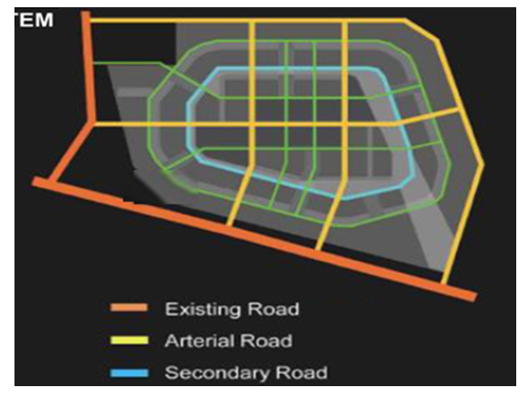 | Figure 15. Network System of BNC (NIC, 2019) |
The nodes: BNT buildings are in a U-shape, and the direction is not specified, each building has a different orientation and the buildings are not directed to the direction of the prevailing winds in Iraq (northwest) (Figure 16). Roads in Basmayah are wide which paved roads leading to the building site, as well as the paved building entrance. Therefore, the study area missing the node's hierarchy. Although, the intersections most frequently mentioned as important nodes were Mall (52 frequencies), Block A (41 frequencies), and Old intersection (10 frequencies). On the other hand, Games square (52 frequencies), Mall square (45 frequencies), Shopping square (23 frequencies), and A9 (10 frequencies) squares were the most and highest frequencies in BNT.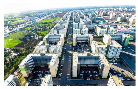 | Figure 16. Residential Buildings in BNC (NIC, 2019) |
Districts: Residential areas are the major districts in BNTC; it is easy to distinguish the residential districts with organized housing patterns, wide streets, and large open squares. BNT is divided into eight sectors (A, B, C, D, E, F, G, and H). Dealing with the topography of the functions of each urban component or land use is separated from the other in the sense that commercial activities are isolated from residential buildings and educational buildings. Commercial areas, mainly shops located in the city center tracted a heavy movement of people and vehicles. Table (1) sectors, number of blocks, and housing units of BNT (Sector A is a case study).Table 1. Sectors, blocks and housing units in BNT
 |
| |
|
Edge: As pointed out by Lynch, edges are visually prominent, continuous in form, and impenetrable to cross movement. They could be defined as paths or boundaries of districts and might often act as edges. BNT consists of eight sectors each sector is divided into several blocks. Accordingly, the proposed arrangement of buildings and the building heights within the project could be seen acting as solid physical edges over the project where tall buildings are intended to be located along districts (Figure 17).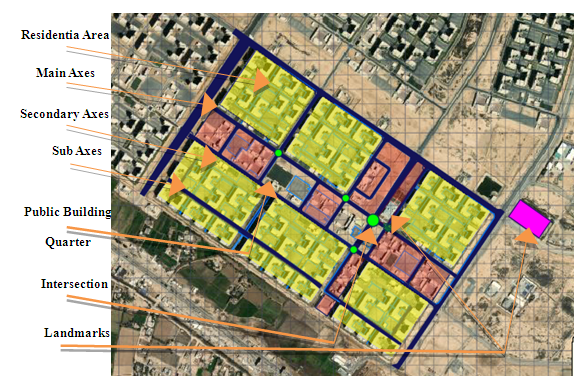 | Figure 17. The basic urban structure of BNT (Author, 2022) |
Landmarks: The BNT presents uninteresting skyline for the area, with no gradual increase in the massing of buildings in the site; in other words, there is no clear image of the newly developed area. There are a few landmarks in the BNCT that have particular shapes like the educational building, mall, and BNT Tower (Figure 18). Many urban studies focused on the importance of keeping these landmarks in the city, not because it’s functional value, but also for what they have from meanings and ideal relations for the area's populations and neighbors. Respondents cited Hanawa Tower (40 frequencies), Mall Building (30 frequencies), Educational buildings (27 frequencies), and others with (12 frequencies).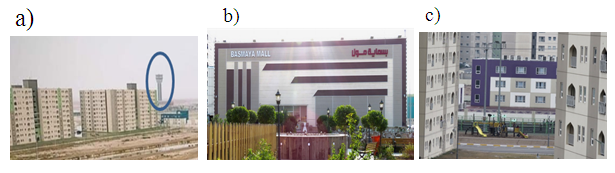 | Figure 18. a) BNC Tower, b) Mall and c) Educational building, (Landmarks) |
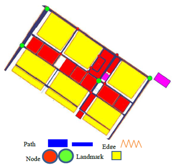 | Figure 19. The image of Bismayah’s first district (Author, 2022) |
3.2. Social Analysis
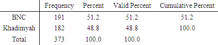
The questionnaire is used to explore social relations in case areas. Questionnaires focused on assessing some indicators; the community profile is analyzed through some fundamental questions, socio-demographics (age, gender, marital status, family size), socio-economic (includes occupation, homeownership), and socio-cultural structure of community (education pattern in a community, length of time the community has been in existence). The physical attributes of case studies areas are investigated too. In addition, some selected domains related to sustainable communities such as sense of place, sense of belonging, safety and security, accessibility and connectivity, recreational facilities and green areas, and services (educational, commercial, and health) are also explored by questionnaire, besides measuring the main urban elements, which was composed of five distinct elements path, edge, district, landmark and node (Kevin lynch, 1960). The number of participants was kept almost equal between the two case studies, with 373 participants in total, 191 participants were from BNT, and 182 participants were from Alkhadimyah (51.2% and 48.8% respectively), as shown in Table 2. Table 2. No. of responses in two case studies
 |
| |
|
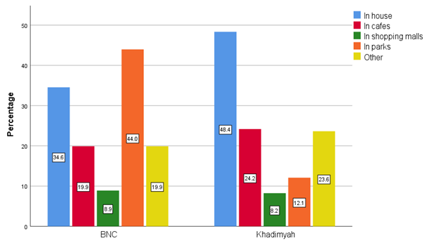
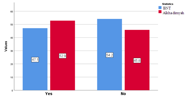
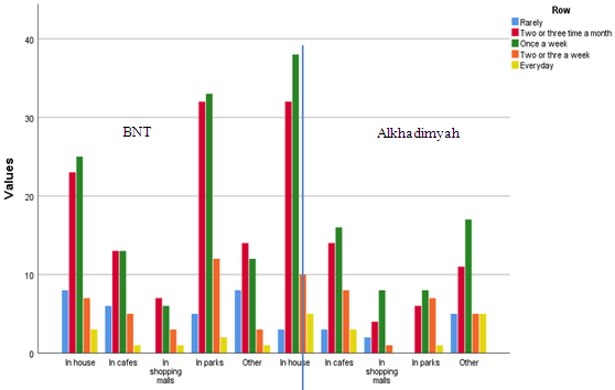
In this section, resident neighborhood relation, resident acquaintance relation, social interactions area/ place, and finally the frequency of meeting with neighbors are considered as the important factors to evaluate the level of social interaction for case studies areas. The questions focus on the neighborhood scale to obtain information about whether the residents have acquaintances, relatives, and friends in the neighborhood, how often they meet with them, and where they prefer to meet with each other. In BNT, 42.1% of respondents have some friends living in the same neighborhood, and 19.3% of respondents see each other two or three times a month. While 18.0% of respondents see each other once a week, 7% of them see each other only rarely. Only 1.1% of residents informed that they have a connection with their friends and relatives living in this neighborhood every day. Most respondents visit their friends and relatives in parks (44%); 34.6% meet at the house; 19.9% meet in cafes and restaurants to see each other; 8.9% meet in shopping malls within the BNT case. 19.9% of residents meet with friends and relatives in other places. Most of the participants meet their relatives and friends once a week in parks, which note that there is normal social interaction on the site. The second most preferred places to meet friends and relatives are in the house. On other hand, in Alkhadimyah, 34.9% of respondents have friends, relatives, and acquaintances living in the same neighborhood. The majority (19.8%( of respondents see each other once a week, 16.4% of respondents see each other two or three times a month, and 7% of them see each other two or three times a week. 3.5% of respondents have a connection with their friends and relatives in this neighborhood rarely and finally, 2.1% of respondents meet every day. Most of the respondents (48.4%) visit their friends and relatives at the house, 24.2% of respondents meet in cafes, 12.1% of respondents meet in parks to see each other, 8.2% meet in shopping malls within Alkhadimyah case and 23% of residents meet with friends and relatives in other places. Most of the participants meet their relatives and friends once a week in house, which note that there is a social interaction in the site. The second most preferred places to meet friends and relatives are in cafes and restaurants. As seen in figures 20, 21, 22 and 23.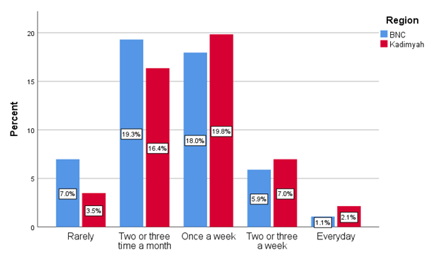 | Figure 20. Percentage of meet and interact with neighbors (Author, 2022) |
 | Figure 21. Place of meet and interact with neighbor in neighbourhood (Author, 2022) |
 | Figure 22. Percentage of participate in neighborhood local activities (Author, 2022) |
 | Figure 23. Correlation between Meeting Frequency and Meeting Places (Author, 2022) |
These findings indicate that people do not utilize open spaces such as public parks and site gardens to increase social connection with other community members. They prefer to meet their families and friends in private places (their houses) rather than public places in Alkhadimyah. Whereas residents in BNT use parks within the site as meeting places, residents in Alkhadimyah rarely prefer to use parks as meeting places. Another difference among them is related to the meeting frequency. Depending on the survey results; Alkhadimyah has the highest meeting frequency. In BNT, this frequency decreases. Furthermore, it might be claimed that meeting frequency is closely connected to social interaction frequency. In other words, the more frequently individuals meet, the more socially engaging they are. These results show that residents generally do not use open areas such as public parks and site gardens to enhance social interaction with other community members. They generally prefer private areas (their homes) to public areas to meet their relatives and friends. As a result, the physical environment of BNT stimulates social contact to a lesser level than the Alkhadimyah site does. According to the study's findings, there are significant outcomes that should be highlighted concerning the social infrastructure and design in the case sites. The findings show that the first case study area, Alkhadimyah, is a place having strong neighborliness ties and a high level of social integration. In general, respondents prefer private spaces like homes and house gardens, but they also use the site's green space as a public outdoor gathering place for social contact. The support and contribution of spatial structure to social communication and neighborhood relations are one of the assessment's primary findings. Another finding indicates that social contact and neighborhood ties strengthen the longer a person spends time in a place.
4. Comparative Analysis of Findings
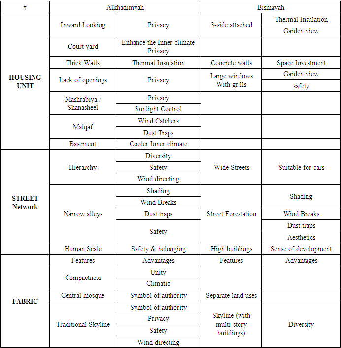
In this part of this research, we applied urban image analysis of two case studies according to five elements of the urban environment (Lynch, 1965), as well as site observation where the cases studied in terms of location, context, and adjacent properties, land use and urban characteristics, demography, and building type. Alkhadimyah is a horizontal low-rise, high-density, and compact traditional urban tissue the houses are close to each other’s, in a compact urban tissue, with small courtyards for each unit. Narrow roads network makes the space environmentally acceptable as the result of producing shade; social interaction and walking priority. The main axis, as a spinal cord from beginning to end, serves as a connector by which all the major components, districts, and activities are linked together. Mixed-used development that provides the varied social group with the option to live work an shop. While BNT is the new urban fabric with large block sizes of the vertical residential project “No Human Scale” and separate land uses, with high-rise buildings in the center (CBD), was represented as the gated compound. Table 3 shows a comparison of the case’s physical attributes and the data collected through observations.Table 3. Physical attributes of Alkhadimyah & Bismayah
 |
| |
|
5. Conclusions
The comparison of case studies revealed that there are variations in urban morphology and planning strategy; Alkadimyah had been relatively unaffected by modernity and had kept much of its historic ethnic and religious diversity. The network of streets, lanes, and cul-de-sacs was one of the significant instances of the Arab World's spontaneously-grown design of towns. All of the structures, together with the household architecture, contributed to the ancient city's unique view. The cityscape was characterized by a classic urban design of low-rise private residential buildings not exceeding 2-3 levels of "human scale”. Alkadimyah used to be a remarkably well-preserved historical setting, with its complicated network of narrow alleyways. While the new urban areas in Baghdad, like Bismayah, are organized according to the modern grid urban pattern, with straight or linear wide streets and alleys with vehicle access and sidewalks. The residential areas are divided into huge blocks, with high-rise apartment buildings that exceed ten levels with a private yard and public car garage (no Human Scale) of the site does not reflect Baghdad's vernacular urban morphology.In this paper, Kevin Lynch’s five elements concept has been applied to better understand the image of the new development area BNT compared to the old one, Alkadimyah. According to the analysis, the findings of the analysis parts demonstrate a significant correlation between the spatial organization and social structure of neighborhoods. Alkhadimyah, which is not easily accessible (segregated), but it accommodates higher social integrations ranking inhabitants. The other significant finding from the spatial and social analysis is that neighborhood with high local integration is not always has high level of Legibility. As a result, it may negatively effect on its social structure like (BNT).By following the different features and their advantages in the Table 3, the following are the primary conclusions that may be drawn:1. The traditional neighborhood of Baghdad gradually changed from its compact form into a grid-iron pattern, due to the influence of modern planning concepts.2. The central mosque has disappeared as a symbol of the collapse of religious dominance and the rise of civic authority, which is symbolized by governmental buildings dispersed across the city.3. The conventional skyline, highly inspired by mosque elements, demonstrated the structure's unity and the supreme religious authority. Multi-story constructions that have been built and are now being built have taken its place. The new skyline, which is in keeping with global expansion, provides diversity and a sense of modernity, however, it also effects on the neighbors’ need for privacy.4. Street widths were correlated with privacy in the organic traditional street network, which was defined by its hierarchy. By providing shade and regulating wind direction and speed, that hierarchy helped people adapt to the severe climate. This organic traditional street network was replaced with a grid-iron network because to the necessity for large roadways that is appropriate for the modern technology (vehicles).5. Human scale is another defining feature of traditional form. It was connecting people with their environment by respecting the notion of container (place) and content (people). The new form, on the other hand, disregards human scale by increasing the place and replacing people with vehicles. As a result, the new city's tall buildings and wide streets make it less hospitable to pedestrians, limiting their options to walkways and marginalizing them.6. Baghdad's climate is severe in general, making it a vital component in architectural design, which has resulted in the extensive use of sophisticated cooling and heating systems within the structures. As a result, the environment and natural resources were suffered.7. Traditional housing units were covered from the elements on three sides by their connection to neighboring units, and on the fourth by the smallness and shadows of alleys. In contrast, modern housing is more open and has less thermal performance.8. The tradition still respects privacy, but contemporary housing strives to combine it with beautiful outside views. In addition to putting the home itself away from streets, this is achieved by creating high walls around dwellings.9. Traditional houses used greenery in their courtyards to improve the mood inside. It is now used in front yards outside.10. Due to the harsh environment, Baghdad's soil is perfect for building basements, which were popular in the old city. Basements were later abandoned when dwellings could provide appropriate interior temperatures by depending on mechanical heating, cooling, and ventilation systems.11. Traditional houses were constructed with thick mud walls and brick, which served as good heat insulators. Concrete is utilized in the development of modern residential projects such as BNT. This reduces the thickness of the walls and reduces their capacity to insulate, but it also allows for more space to be used.12. In light of the current dependence on mechanical cooling and heating technology, mashrabiyas and malqafs, which were once employed for cultural and climatic purposes, are no longer used. If such components are still employed for their original purposes, they are only decorative. This study reveals that the idea of Legibility at the urban neighborhood scale has critical significance in the social quality. It implies that a neighbourhood with better visibility would attract more visitors and users. As a result, these neighbourhoods would become more densely populated and economically active, which would eventually lead to an improvement in their social structures.Finally, it should be stressed that without taking the political situation into account, particularly if the city is affected by war, studying urban neighborhood scale in connection to socio–spatial integration, would be incomplete. Because a war would be an interrupted process of urban transformation in both spatial and social dimensions. This was also accurate in Baghdad, which saw significant socio-spatial transformation after 2003 as a result of political difficulties (conflict). On the other hand, the neighborhood in suburbs shared comparable traditions and habits but significantly lacked social interactions. The lifestyle of residents is compatible with the local culture in terms of religion, language, and societal traditions.
References
| [1] | Al-Dujaili, Sahar, Baghdadi Alkhadhimiya /aladamiya – development of historical districts and situation today, Research In The Conference Of “Urban Development Of Baghdad And Further Cities In Iraq”, Btu, Cottbus, Germany, 2010. |
| [2] | Al-Ahbabi, S. H., & Neama, S. J. (2011). Mechanisms of Achieving The Social Sustainability, In The Traditional Urban Structure. Journal of Engineering, 17(3), 133-155. |
| [3] | Al-Rahmani, S. F. (1986). Principle for urban renewal in Iraq: a study to develop town planning principles for the renewal of the Iraqi cities with particular reference to Baghdad central area. PhD Thesis, University of Manchester. |
| [4] | Al Siliq, G. M. R. (2008) Baghdad: Images and memories. [Online], [accessed 28th November 2015], DC. Revista de crítica arquitectónica, 2008, núm. Ciudad del Espejismo: Bagdad, de Wright a Venturi, p. 49-72. Available from: http://hdl.handle.net/2099/6882. ISSN1887-2360. |
| [5] | Atik, D. Z., Çakir, H. K., & Benian, E. (2009). The Importance Of City Image Elements Through Recognizing and Introducing of Cities: Edirne Example. Trakia Journal of Sciences, 7, 246-251. |
| [6] | Behsh, M.B. (1993). Towards Housing in Harmony with Place. Sweden: Lund Institute of Technology, Lund University. |
| [7] | Behsh, M.B. Towards Housing in Harmony with Place. Sweden: Lund Institute of Technology, Lund University, 1993. |
| [8] | Bianca, S. (2000a). Basic Principles of Islam and their Social, Spatial and Artistic Implications. Urban Form in the Arab World: Past and Present. London; New York: Thames and Hudson, 23-46. |
| [9] | Eben Saleh, M. A. (1997) Privacy and communal socialization: The role of space in the security of traditional and contemporary neighbourhoods in Saudi Arabia. Habitat International, 21(2), pp. 167-184. |
| [10] | Hillier, B., & Hanson, J. The social logic of space. Cambridge, U K: Cambridge University Press, 1984. |
| [11] | Ihsan, F. Urban Conservation in Iraq. PhD Thesis, University of Sheffield, UK, 1977. |
| [12] | Jacobs, J. The death and life of great American cities. Middlesex, England: Penguin Books, 1961. |
| [13] | Lynch, K.. The Image of the City. Cambridge: The MIT Press, 1960. |
| [14] | Lynch, K., Good City Form, Cabridge: The MIT Press, 1981. |
| [15] | Mahgoub, Yasser, and Khalfani, Fatma. “Sustainability of Gated Communities in Developing Countries.” Developing Country Studies 2, no.6 (2012): 53-63. |
| [16] | National Investment Commission and Hanwha Engineering and Construction Corporate. Bismayah New City-National Housing Programme, Baghdad, Iraq, 2019. |
| [17] | Polservice Consulting Engineers. Kadhimiya Old Quarters, A report submitted to Amanat al-Assima of Baghdad, Warsaw, pp. 14-41, 1974. |
| [18] | Susa, A., Atlas Baghdad, Baghdad, Mudiryat almasaha, 1952. |
| [19] | UN-HABITAT. (2005). The State of Iraq Cities Report, Cities in Transition. In collaboration with global urban research unite, school of architecture, planning and landscape, Newcastle University, united nations human settlements programme (pp. 95-160). |

 Abstract
 Reference
 Full-Text PDF
 Full-text HTML