-
Paper Information
- Paper Submission
-
Journal Information
- About This Journal
- Editorial Board
- Current Issue
- Archive
- Author Guidelines
- Contact Us
Architecture Research
p-ISSN: 2168-507X e-ISSN: 2168-5088
2021; 11(2): 31-52
doi:10.5923/j.arch.20211102.01
Received: Jun. 9, 2021; Accepted: Jun. 22, 2021; Published: Jun. 26, 2021

Effectiveness of Planning Tools in Managing the Spatial Stability of Peri-Urban Areas
 Abstract
 Reference
 Full-Text PDF
 Full-text HTML
Charles Otieno Konyango, Patrick Odhiambo Hayombe, Fredrick Omondi Owino
Department of Spatial Planning, Jaramogi Oginga Odinga University of Science and Technology, Bondo, Kenya
Correspondence to: Charles Otieno Konyango, Department of Spatial Planning, Jaramogi Oginga Odinga University of Science and Technology, Bondo, Kenya.
| Email: |  |
Copyright © 2021 The Author(s). Published by Scientific & Academic Publishing.
This work is licensed under the Creative Commons Attribution International License (CC BY).
http://creativecommons.org/licenses/by/4.0/

Rapid growth and conversion of rural lands into urban places and urban growth management becomes indispensable, especially the need to control the amount, type, extent, rate, and quality of resultant places. In other words, the need to manage how much growth occurs, its character, where it occurs, how fast it happens, and with what impacts; are all-important. Therefore, the study sought to evaluate the effectiveness of planning tools in managing the peri-urban land use change process towards achieving spatial stability. Particularly, it investigated turnaround time for development applications, criteria for development approvals, site visits and inspection of developments, criteria for approval of building plans, application for development permission, and issuance of notice of approval/deferment/refusal. The research was guided by the Theory of Change (ToC) and was informed by a cross-sectional survey research design. Data was collected through questionnaire administration, focused group discussions and interviews. The research hypothesized that there is no significant association in the compliance levels between prescribed and applied physical planning standards. This was tested by use of Chi-square test which demonstrated that despite there being a clear manifest variance in the difference between prescribed standards and applied standards of development compliance, there was no significant association in the categories of low-density developments (chi-31.640, p-value 0.000) and the medium density residential development category (chi-20.347, p-value 0.000). However, in the high-density residential category (chi-4.903, p-value 0.297), the test results indicated a strong association hence, the null hypothesis was rejected. Further, the study found that urban development plans have not been effective instruments for control and guidance of the development of peri-urban places. This necessitates the rethinking of urban planning concepts that have shaped the understanding of the peri-urban development. This study argues that the land use change and the spatial restructuring of peri-urban places will be the most critical because there is no planning system or institutional frameworks to manage the transformational processes towards spatial stability.
Keywords: Spatial Stability, Planning Tools, Peri-urban Areas
Cite this paper: Charles Otieno Konyango, Patrick Odhiambo Hayombe, Fredrick Omondi Owino, Effectiveness of Planning Tools in Managing the Spatial Stability of Peri-Urban Areas, Architecture Research, Vol. 11 No. 2, 2021, pp. 31-52. doi: 10.5923/j.arch.20211102.01.
Article Outline
1. Introduction
- Peri-urban areas are interface zones from rural - urban landscapes located in the fridges of urban, regional, and the rural areas (Butsch & Heinkel 2020). Their boundaries are often described as porous and transitory as human settlements extends into rural areas (Charles, Galal & Guna, 2018). Over the years, urban growth and encroachment into the rural fringe areas has been a growing trend all over the world and the process is occurring rapidly, especially in developing countries. UN-Habitat (2020) documents that only ten percent (10%) of the world’s population lived in cities at the beginning of the 20th century and increased to 50% by the start of 21st century. A bigger percentage of this growth and the resulting human settlements and population were domiciled in the urban fridge areas (Salvia, Zamfir, Cividino, Salvati, & Quaranta, 2020). The impact of this phenomenon is a major spatial change of the peri-urban landscapes. Butsch and Heinkel (2020) stated that urban areas worldwide are faced by severe challenges as a result of unprecedented metropolitan growth, most evident in peri-urban areas. Similarly, ineffective spatial planning and development control leads to spatial disorganization owing to rapid physical, social and economic transformations (Chigudu, 2021). United Nations (2020) indicated that expanding urban areas was attributed to increasing population in the developing countries. This urbanization exerts pressure on natural resources and the new forms of land uses in the peri-urban areas. Moreover, 50% of Africa’s population is to live in urban areas by the year 2030 (UN-Habitat, 2020). This and subsequent demand for urban land will be achieved through land use conversions from rural agricultural land into human settlements (Osumanu & Akomgbangre, 2020). This is because urban growth in Africa is mainly horizontal and spatially disaggregated.Over the years, peri-urban developments have increased in Kenya as a result of rapid urbanization at an annual rate of 4.15% (KNBS, 2018). The population displays dramatic increase in urbanization rate from 8 per cent in independence to 19% in 1989 and 19.4% in 1999, and by 2017, 26.6% of the overall population of Kenya resided in urban areas (KNBS, 2018). The urbanization process in the country has also been unevenly dominated by spontaneous expansion and haphazard development which has occurred predominantly beyond urban planning initiatives (UN-Habitat, 2020). At the National level, urban planning was historically influenced by a complicated administrative system in which the formulation of the plan was a central government activity and the local government was responsible for executing it (UN-Habitat, 2020). Subsequently, urban development plans were not mindful of demands and neither did they address local challenges, leading to poor execution of proposals.Consequently, urban planning strategies have not been successful, as critical tools for managing and directing urban development have not been properly enforced. According to Ritchie and Roser (2018), four inescapable facts define the thinking of urban growth in the 21st century. First, most countries would eventually have the bulk of their population in urban areas. Secondly, a significant portion of this increase would occur in Africa and Asia, where less than 50% of the population currently lives in urban areas. This phenomenon has significant spatial and demographic implications given that the volume of increase in urban population will be unparalleled in human history (Ren, Guo, Zhang, Kisovi & Das, 2020). Suffice to state also that this population increase will cause significant spatial restructuring of the peri-urban places as the growth of towns will most certainly occur horizontally through encroachment into the rural hinterlands. Thirdly, along with the modernization of fiscal, social and political practices, emerging demographic realities would demand a rethinking of the conceptions of urban and rural environments that have dominated the perception of urban and rural areas (McGhee, 2009). This study looks at the 'peri-urban' areas and argues that land-use reform and spatial restructuring of peri-urban areas are necessary because of inadequate planning mechanisms or institutional structures to manage their transformational processes and spatial stability. Thus, rethinking peri-urban land use change and spatial transformation is necessary to manage its uneven growth and mixed character. Furthermore, a uniformly accepted definition of peri-urban areas does not exist. It has been variously described as urban edge, urban fringe, urban-rural interface, and as urban rural transition area (Cattivelli, 2021). UNEP (2019) defined peri-urban areas as dispute zones where modern and existing land uses clash with each other and land is transformed from a dominant agricultural landscape to multi-functional ecosystems. Etemini and Yakubu (2015) defined it as areas that bring significant barriers to the use and control of resources; an area of possible disputes (social, economic, environmental) and where sustainability is the main concern. According to Varkey and Manasi (2019) the peri-urban interface can be described as areas marked by rapid demographic, economic, environmental, social and cultural changes around cities and towns. Malik, Zubair, Griffiths and Lukac (2019) described peri-urban areas as regions of transformation from rural to urban land use, situated between the outer limits of urban and rural areas. Ricci (2019) described peri-urban areas as urban fringes where encounters take place between rural and urban individuals and social classes, and where both conventional rural and urban features coexist. According to Omair (2016), the most typical features of peri-urban areas are: comparatively low population density, mixed land use and rapid land use transition, land speculation and unpredictable land tenure, fast-growing population and infrastructure needs, a combination of immigrants and long-established dwellers, heterogeneous and evolving social and economic systems, and a fractured institution. Nuhu (2019) reiterated that the literature specifically relevant to peri-urban interface is far from substantial, and even the concept of peri-urban interface is contradictory. Studies regarding the land use change and peri-urban spatial configurations are scarce, and what exists does not often analyze land use change processes with depth. Butsch, and Heinkel (2020), confirmed this position, noting that the major issues relating the peri-urban interface have been somewhat neglected, but it is essential to evaluate the peculiarities of the concepts and models of peri-urban growth. It is therefore possible to develop a theoretical perspective within the wider literature on rural-urban connections and linkages. This study therefore fills this gap, including land use change processes and implications on peri-urban spatial construction. It also creates a connection between changes in land use and spatial instability in peri-urban areas (Doernberg & Weith, 2021).Agheyisi (2018) noted that peri-urban is both a place and a concept. The place viewpoint corresponds to rural agricultural areas situated between urban and primarily agricultural areas, while the peri-urban concept is often seen as the nexus between rural and urban practices and transformations where rural and urban growth processes converge, interact and connect on the periphery of cities. As a result, peri-urban areas are a blend of urban and rural systems, leading to a framework of pluralism and disputes (Martin-Moreau & Ménascé, 2019). From a topological perspective, studies have concentrated on the geometry of land uses and their spatial relations and change in shape and size of land uses (Purevtseren, Tsegmid, Indra, & Sugar, 2018). In this line of thought, as the City expands beyond its administrative boundaries it causes change in the proximate rural areas. Biegańska, Środa-Murawska, Kruzmetra, and Swiaczny (2018) looked at peri-urban place as a process rather than a state. The process involves rural areas on the countryside that become urban in nature; physically, economically and socially; often in a fragmented manner. It is characterized by structural changes in land use, growing populations, increasing land values and mixed land use. In the process, agricultural communities are compelled to urban or industrial lifestyles in a very short time, often with gradual environment degradation; enormous land conversion; and infrastructure bottlenecks, which are legislative constraints. Karg, Hologa, Schlesinger, Drescher, Kranjac-Berisavljevic and Glaser (2019) noted that the term peri-urban has gradually evolved from a spatial meaning of rural-urban edge to interpretations that reinforce social and economic underpinnings or transition areas bound to be urban. Accordingly, these understandings of peri-urban are geographical, suggesting that it is a region around the developed area of a city, or a rural-urban periphery where countryside land uses overlap (Miloslavich, 2018). As a geographical entity, the site includes new types of rural-urban mixed land use and creates a frontier of strain between urban and rural land use. In prosperous areas, disputes will emerge between landscape identity, history, environmental health and suburban development, replacing fertile agricultural land (Warner, 2019). In less developed regions, peri-urban challenges include insecurity, illegal settlements, disjointed developments and poor housing; geographical imbalances; land use disputes and spatial incongruence (Anne-Marie, 2005). Going by these descriptions, this study adopts an understanding of peri-urban in spatial terms as a transitional space that attempts to make sense of change. These concerns cannot be dealt with only in spatial terms, but require appropriate policy interventions to manage the land use change towards spatial stability. Kawu, Ahmed and Usman (2012), described peri-urban areas as pre-modern territories that require comprehensive environmental management and protection. Effective control of developments in these pre-modern sectors, however, is difficult because of lack of rules, guidelines and standards for adherence. According to Ravetz, Fertner and Nielsen (2013), peri-urban is a zone of socio-economic change and spatial restructuring, and of chaotic urbanization leading to sprawl. Goswami, Nautiyal and Manasi (2020) stated that the peri-urban paradigm should be lifted beyond comprehension solely in terms of location and land use. Thus, it should be seen as the confluence between rural and urban practices and, in essence, as a process rather than a location. This implies that the essence of peri-urban interface is one of a continuous transition due to diversity of living standards and spatial configurations (Goswami, Nautiyal & Manasi, 2020). Nyarko and Adu-Gyamfi (2012) observed that peri-urban regions are areas of land use disputes and that policymakers need to consider these tensions in order to make informed decisions on land use planning and conflict management.Tesfaye (2019) assured that peri-urban areas are experiencing complex processes and are associated with high diversity and gradual land use changes. The processes inevitably lead to an area characterized by an in-between situation, neither urban nor rural, and home to a variety of roles, ranging from agriculture to residential, industrial, commercial and recreation. United Nations (2019) observed that peri-urban areas are experiencing significant changes of land use systems, culminating in extreme environments of instability and dispute. These transitions are the product of a dynamic interplay of multiple roles influencing the land use and social structures of peri-urban areas. Pravitasari (2015) support this view by indicating that peri-urban places experience many complexities in land use change, and that researchers have continued to suggest a one-size-fits-all model to satisfy the variability of primary drivers and landscape functions. In order to address resulting tensions, conflicts and complexities in peri-urban areas, this study investigates participatory frameworks that provide for the management of the land use dynamics and combines parameters from both the physical, socio-economic and ecological parameters to determine changes overtime. Nielsen, Nyaaba and Akongbangre (2019), notes that peri-urban areas have become an avenue for spatial research but, to a limited extend, space-planning research has been applied in this field. Ruoso (2019) who supported that the peri-urban areas are still mostly under-studied. Güneralp, Lwasa, Masundire, Parnell and Seto (2017), alluding to population growth in developing countries, noted that, despite comprehensive literature on individual city planning and management in different areas of the global south, limited consideration has been devoted to peri-urban areas. (Güneralp et al. 2017). Dutta (2013) noted that urban intrusion into peri-urban areas takes place through edge expansion and development. However, the spatial implication of this development is underexplored. Gyasi, Fosu, Kranjac-Berisavljevic, Mensah, Obeng, Yiran and Fuseini (2014) observed that urban strain on the peri-urban environment is exacerbated by the increasing demand for land for more beneficial investments than for agriculture - based purposes. Enforcement of strategies meant to regulate the process were weak and supportive policies were absent. Agheyisi (2018) stated that there is lack of spatial land-use framework for regulating land use matters and that local authority by-laws do not effectively address peri-urban development control. This study attempts to fill the lacuna by evaluating the effect of land use transition on the spatial stability of the peri-urban areas of Siaya Township Ward and proposing a framework for effective development control and management of the land use change process and peri-urban spatial transformation.Dennis (2019) evaluated urban ecosystem qualities as a component of land-sharing-saving, urban and intensity using a combination of RS and GIS techniques. The findings suggested possible trade-offs between land-sharing dynamics arising from simultaneous impacts of patch characteristics such as land cover and scale, suggesting that both ecosystem conservation and space planning have a vital role in resolving the conflicts between land-sharing and conservation approaches. The study clarified that the peri-urban area contains a diverse blend of ecological and productive environmental services functioning in conjunction with distinct socio-economic characteristics. This affirms the argument that peri-urban areas have numerous land-use functions that include a fragmented cluster of residential, economic and occasionally diverse agricultural uses (Mandere, Ness, & Anderberg, 2010). It is in these terms that one can recognize that peri-urban spatial instability is a phenomenon in the spectrum of land use change. Tiwari (2019) ascertained that a peri-urban area is, in itself, a dynamic zone, of a transient character and marked by neglect, neither urban nor entirely rural, and lies beyond the jurisdiction of planners on either edge. Tiwari (2019) analyzed the conceptual aspects of the peri-urban and established that the region is managed from two perspectives, namely economic and ecological. This however leaves the spatial aspects of the region as a vital gap in the link. This study embraces the peri-urban region as part of the city’s hinterland that has economic, ecological as well as spatial role in the sustenance of both the urban and rural zones. As such, there is need for consistency in spatial planning strategies and guidelines for handling peri-urban areas (Brunetta, Monaco, Salizzoni, & Salvarani, 2018). As a link in the transition from urban to rural land spaces, a holistic understanding of the peri-urban system is vital for its management, resource utilization and livability (Dadashpoor, Azizi, & Moghadasi, 2019). From this observation, there is need to formulate new frameworks of plans for land use changes of these fringe areas so that absolute haphazard developments do not create irreversible loses to the human ecosystem linkages (Hernantes, Maraña, Gimenez, Sarriegi, & Labaka, 2019). The study fills this gap by analyzing land use change overtime, examining the effectiveness of land use planning systems and investigating participatory framework for integrating the land use change agents and spatial management structures to deliver spatially stable peri-urban places.Cirolia and Berrisford (2019) noted that, in the recent times, more focus of research on peri-urban areas has been on the necessity of planning to extend its scope from a theoretical to a practice-based paradigm, with focus on the strategic and spatial aspects of planning. Surya, Ahmad, Sakti and Sahban (2020) observed that the primary issue now lies in the degree to which planning can be a regulatory initiative and have a greater responsibility for handling complex social, physical and economic patterns. Interpolated on the concept of land use transition and spatial transformation, it increases the need to identify a scientific premise that describes the connection between these two trends in peri-urban areas (Global Land Tool Network, 2018). This study therefore suggests a new planning paradigm for regulating peri-urban land use, with a focus on the linkages between land use transition processes and their spatial outcomes.Achamyeleh (2014) studied urbanization and land conflicts in the peri-urban areas of Ethiopia using a blend of desktop analysis and case study approaches. The research found that the peri-urban areas witness most changes emerging from the heterogeneity of community. These areas are marked by disorganized developments with poor social services and infrastructure; as squatters appropriate of land for investment purpose, unclaimed territory subdivisions and acquisitions, and illegitimate land occupations (Achamyeleh, 2014). Peri-urban areas would also require land use planning and management options to control the spatial outcomes of the transition. Amoateng, Cobbinah and Owusu (2013) investigated the management of physical changes in the peri-urban areas of Kumasi, Ghana using a case study approach utilizing primary and secondary data sources and found that peri-urban areas are marked by rapid and uncoordinated growth and development. The uncontrolled pattern of expansion in these areas has resulted in dynamic exponential urban growth, which primarily grows horizontally and entails increased development of residential and non - residential uses and a reduction in primary rural activities.In conclusion, this research considers that successful management of peri-urban land use change is essential to resolve the challenges of spatial instability, especially in areas with rapid urban sprawl and with a view to achieving sustainable growth and sustainable peri-urban areas. Owing to the complexity of the transition in peri-urban land use, several studies have sought to suggest a one-size-fit paradigm to suit the variability of communities (Busck, 2013). Any framework that attempts to regulate change in land use and the spatial development of peri-urban areas must incorporate geographical, socio-economic and ecological settings. Erhardt and Dennett (2017) contributed to this dimension by noting that most peri-urban areas reflect a disjointed landscape, and that numerous researches on land use changes relied on quantitative data from census data and statistics on land use. This research asserts that land use changes in peri-urban areas is a complex phenomenon and adopting both quantitative and qualitative approach provides a more objective path to examining the systems which shape the land space.
2. Literature Review
2.1. Land Use Planning and Development Control
- Development control is a tool for managing land use, the primary objective of which is to promote public gain. Abu (2015) indicated that development control is a process that is an indispensable tool of planning. That is the means by which the Government intervenes to govern land use development in order to enforce local and national planning guidelines (Silva, Nielsen, & Bedi 2020). It follows, therefore, that development control can be an important comprehensive tool for controlling changes in land use. Airey and Doughty (2020) argued that development control ensures that developments take place at a legitimate place and time in a manner commensurate with a prescribed set of policies and standards. Further, they added that the overarching goal is to guarantee organized and logical development of land in order to establish habitable settlements that encompass a range of land uses to address the needs of society (Surajit & Negi, 2016). According to Chriqui, Thrun, and Sanghera (2018), physical planning standards used in development control can be categorized as locational and space standards. Location standards inform the positioning of land uses or services and are provided in the acceptable contexts. Space standards signify extent of space required to meet such needs which should not go below the recommended minimum standards (Nucci, 2018). They strive to achieve effective land use by minimizing congestion and supporting appropriate operation of services. The level of conformity with the standards defines the spatial stability and functionality of the built-up area. In Kenya, zoning and land use development standards are laid out in the Physical Planning Regulations (1998) and, more precisely, in the Physical Planning Handbook (2017). The Planning Handbook provides recommended standards for buildings, density control, plot coverage and the number of dwelling units per plot, building setbacks, plot ratio and plot coverage; congruence and compatibility of developments and hence spatial stability. The most common instrument for development control is land use zoning. Nel (2016) describes zoning as the demarcation of urban areas using town planning ordinances and regulations to govern the use of zoned land. Rodrigue (2013), however, defines zoning as the process of organizing the growth of urban areas in a systematic order by setting up categories, classes, and zones of land in a location, prescribing the uses to which land may be put and applying uniform regulations on the shape and placement of developments. These regulations define land use in particular areas and provide guidelines for plot size, density and floor space ratio. The zoning lays down the statutory framework that defines permissible land uses and establishes the distinction shall between various forms of land use (Berliner et al., 2020). It also guarantees that conflicting land uses are not situated next to each other and also establishes setbacks and criteria for urban safety and stability (Grochowska & Małecka, 2020). Accordingly, this study asserts that any city planning authority ought to have a zoning toolkit that contains additional regulations covering particular forms of development, as well as the nature and performance of public spaces. Development control is thus a regulatory endeavor primarily undertaken by a specified land use or development certification process, whereby applicants submit requests for their proposed development plans to be determined by the approval authority (Commonwealth of Australia, 2017). Those concerned with the execution of such functions have an obligation to ensure that developments take place in the prescribed manner. Pursuant to the Physical Planning Regulation (1998), development control requirements include; land use assignment through zoning; the form and extent of the planned use and its permissible circumstances; conformity to recent and adjacent land uses; possible amenity effects; Consequences on recent or planned public services and infrastructure; proximity to ecologically vulnerable areas; compliance with certified plans, initiatives, and policies; and characteristics of land and its surrounding. In addition, the Republic of Kenya (2009) acknowledges land use planning as central to the effective and productive management of land. The National Land Policy (2009) states, however, that hardly any attempt has been done to ensure that such policies are successfully planned and enforced. The policy recognizes that there's been a strong technical gap by planning and implementing agencies. Such deficiencies include inadequate technological and institutional capacity, lack of extensive consultation as well as inefficient coordination of planning process. Consequently, the policy recognizes a knowledge deficiency that leads to this research. Primary concerns that need to be explored include: (a) the formulation of land use plans on the basis of predefined priorities, integration of rural and urban development; and the creation of an effective framework for public involvement in planning. Thus, this study bridges these gaps by examining peri-urban land use changes overtime; investigating effectiveness of land use planning systems in peri-urban areas; and further analyzing participatory frameworks for land use change management. notably, the policy acknowledges that peri-urban land development has been hampered by poor planning, exponential growth in human settlements and practices, outright urban sprawl and insufficient infrastructure. To this end, the policy proposes that planning process should be operationalized through public participation. The policy therefore endorses the need to develop an appropriate planning process for the preparation and implementation of development plans. The research resolved this by creating vital institutions (departments) and their mandates in the management of peri-urban land uses. The shortcomings of planning and development control include; (1) Poor coordination between public and the private sector; and (2) inefficient connection between preparation and implementation of development control strategies. Makato (2016) indicated that development control is administered by means of predefined methods, including development standards, zoning and compliance notices for violations and conditions associated with the execution of projects. It is acknowledged, however, that regulations on land use management are applicable primarily to urban areas, but the peri-urban areas do not have effective control guidelines due to the absence of legislative mechanisms specific to peri-urban areas, yet they offer a vibrant growth frontier with a range of challenges.Owei, Obinna and Ede (2010) argued that the purpose of development control is to ensure that activities are planned and implemented with due regard for the preservation of the public interest, including safety and health, comfort, efficiency, environmental integrity, social equity and preference. Aluko (2011) defined development control as a powerful tool for city management that promotes continued growth and management of the city in a way that ensures rationality, great city identity, health and aesthetics. It also means that environmental problems are minimized to permissible standards. The fundamental constraint for development control stems from unregulated change in land use, non-compliance with spatial planning regulations and permitted design, poor implementation of development regulations (Chriqui, Thrun, & Sanghera, 2018). as a process, it controls the development of land in accordance with approved plan. It is a very delicate task which must be undertaken with caution, firmness and profound sense of obligation by the concerned authorities (Aluko, 2011). The process includes: zoning; spatial planning standards, such as setbacks, plot coverage and building heights. Owei, Obinna and Ede (2010) observed that urban growth originates mainly from enormous development of settlements beyond the structured framework of public land use controls. In the process, informal settlements are growing, particularly on the urban fringes, which make it difficult to provide infrastructure such as roads, sanitation, markets and recreation areas. This concurs with Metternicht (2017), who argued that the aim of appropriate development control is to counter land use deterioration induced by unregulated usage.In Africa, the African Planning Association (APA, 2013) asserted that prevailing economic development and population growth should be driven by effective planning and land use management. This is to ensure that emerging human settlements are effective in satisfying the needs of its occupants; and to guarantee inclusive social and economic development. What APA (2013) didn't explore is spatial stability as a management issue for urban growth, in addition to economic, environmental and social dimensions. This remains the most challenging issue affecting urban development in the rural regions of Africa. Moreover, the problem persists mainly attributable to the fact that existing planning framework is rooted in historical contexts and has become obsolete and unresponsive to modern changes. More pertinent planning policies are therefore desired to leverage transformational realities and consider the informality of practices in the peri-urban areas (Priya, Singh, & Das, 2019).Ahmed and Dinye (2011) examined urban growth and development obstacles in Ghana: a case study of Wa Township. The research utilized primary and secondary data from landlords, tenants and property managers as investigation groups. Results suggested that effective development control, especially in areas with exponential urban sprawl, was done to combat land use conflicts such as slum emergence, inappropriate land use, congestion among others, and to promote sustainable development. In most instances, development happens before planning and the process is often so swift that attempts to control spatial re-organization is futile (Ahmed & Dinye, 2011). This is in line with the findings of Chigbu, Schopf, Vries, Masum, Mabikke, Antonio and Espinoza (2016) that effective and efficient spatial planning is not well defined in many developing countries. The most evident form is the dysfunctional situation of land uses in peri-urban areas where population growth has culminated to unplanned and uncontrolled developments (Miljković, 2012). UN-Habitat (2018) suggested that development control is a spatial planning framework for the management of land use changes. Its aim is to ensure efficient implementation plans and to regulate the flow of infrastructure (UN-Habitat) (2018). Inefficient spatial planning results in to uncoordinated land use patterns without reference to any planning principles. Nha (2017) pointed that the nexus between spatial planning and development control, relating to spatial planning as a way of managing changes in land use and the ability to assign land use to areas that are better suited to this practice. However, since planning deals primarily with prospective changes in land use, it depends on developers and land managers to initiate the changes. This is mostly in the peri-urban areas, where land ownership is predominantly freehold and land use change is still regulated through informal systems (Lombard, 2015). Development control is therefore, requires the pursuit of a balance between congruence and prosperity on the one side and socioeconomic interests on the other. In the peri-urban areas, there is need to balance between the interests of freehold owners and the general interest of the society as reinforced by the planning authorities (Bah, Faye & Geh, 2018). Generally, land use management is sought by organizing land into areas in which developments are either authorized or prohibited (Berliner, Boden, Boucek, Hamilton, Hermann, Neily, Riches, & Wake, 2020). However, land use zoning, does not adequately specify the complexity of land uses changes. A planning framework defines zones to regulate land use developments. Nevertheless, zoning should be supplemented by relevant criteria to aid in determining if plans for land use change are compliant with permissible land use typically defined under the zoning framework (Berliner et al., 2020).Dambeebo and Jalloh (2018) indicated that effective and efficient land use planning and management in many developing countries is not well formulated to facilitate orderly urban growth. On the other hand, the intention of planning is to guarantee that urban growth is coordinated and implemented with due regard for convenience, effectiveness, sustainability, environmental conservation and social equity. Kamau (2015) suggested that development control could play an integral role in guiding peri-urban development. Land use change is partially driven by land speculation, as new developments happen arbitrarily, and are fragmented without form. Thus, there is also need to formulate plans for managing land use changes so as to deter disorganised developments in the context of peri-urban prosperity (Perrin, Clément, Melot, & Nougarèdes, 2020).Richmond, Myers and Namuliurban (2018) examined urban growth and agricultural land losses in the peri-urban area of Osun State, Nigeria. The research aimed to determine the intensity, trend and consequences of unregulated spatial change using descriptive statistics and GIS. Results indicated a rise in built-up areas from 6.6% in 1986 to 20.1% in 2014, at the expense of agricultural land. As a result, agricultural land declined from 62.7% to 54.0% in the same period. The study concluded that developments occurred outside formal land use management processes. This leads to informality, contradictory and sometimes conflicting uses, which make it impossible to deliver infrastructure services. The overall outcome of this is spatial instability, thus the reason for a proper land use and growth management plan. Dekolo, Oduwaye and Nwokoro (2015) further asserted that urban growth in most developing countries is unpredictable, varied, disorganized and spatially expansive. This development, which is correlated with sprawl, occurs in outlying areas of cities, resulting in the loss of biodiversity and the reduction of agricultural space (Coulibaly & Li, 2020). Generally, there is often a lack of appropriate planning and development control in peri-urban areas, prompting unguided growth.Makunde (2016) studied the powers of local authorities in Zimbabwe and how they control development, and established that the idea behind development control is hinged upon the need to balance between the forces of free market economy and the responsibility of the government to regulate and suppress unauthorized land use and speculation. Mainly, the concept of development control has been limited to the built-up areas, yet other areas of undeveloped areas, especially in rural and peri-urban areas, require attention. Makunde (2016) asserts that, while the idea of development control has been perceived and misinterpreted by different researchers, the gist of compromise between relevant parties was to sort development control to ensure that spatial stability.While several studies on the peri-urban interface have focused on land use change and agricultural economics, empirical investigations on the drivers and policy responses to spatial integrity remains lacking in literature (Dekolo, Oduwaye & Nwokoro, 2015). Thus, this study sought to investigate a participatory framework that guides policy responses towards effective land use change management and spatial stability in peri-urban areas. Thuo (2014) argued that rising population means growing demand for urban space. This land is not available within the city, but in rural-urban areas, partially due to low land values and legal autonomy in spatial planning. Urbanization is therefore ravaging existing farm land and small settlements, resulting in significant changes in spatial order, social structure, land tenure and land market (Bertrand, 2019). However, these transformations take place without outright regulatory authority, or structured institutions to handle developmental control. There exist conflicting responsibilities among government actors on responsibilities and mandates on planning and development management. Due to these conflicts, there arises inconsistency in land use planning decisions and land use change issues which are rarely addressed. Thuo (2014) determined that land use planning in the peri-urban places is handled by different state agencies independently and with different standards. For instance, Kenya's Ministry of Agriculture endorses regulation of land subdivision to a minimum of one-half acre, while local authorities and the Ministry of Lands approve it to a minimum of one-eighth acre. Olima (2014) studied land use planning in Kisumu and Eldoret towns as an instrument for furthering orderly urban development. The research interrogated whether land use planning can sustain and encourage orderly urban land development and how land use and development can be synchronized with land control mechanisms. The study established that Kenya's experience with land use planning indicates lack of adequate procedures and rules to allocate, control, approve and regulate urban land development. The manifestations of in-effective land use planning are proliferation of informal and slum settlements; uncontrolled and inefficient land uses, uncoordinated and haphazard mixed developments, and illegal and unapproved developments. The study concluded that causes of problems connected with land development planning are multi-dimensional in nature; legal, technical, organizational and administrative. Kimani and Musungu (2010) indicated that, in view of the planning structural system, the Physical Planning Act, Cap 286, described a set of proposals that could be formulated to manage land use transitions. They include action area, subject, advisory and zoning plans (RoK, 1996). Nevertheless, the efficacy of development control has been undermined, among other factors, by weak institutional capacity to evaluate and validate plans. This in effect created disharmony in land use change, management and land utilization. Kimani and Musungu (2010) observed that the existence of the present planning framework made it impossible for developers to grasp the planning standards and induced inconsistencies that made enforcement cumbersome. Thus, there has been rapid uncoordinated urban encroachment into rural areas and mushrooming of developments without control (Kalabamu, 2019). These plans were therefore inefficient as a guide towards spatial stability. The planning standards required to guide development through various control mechanisms were not clearly articulated in the plans hence the guidance was virtually absent. The National Land Policy (2009) introduced a new framework to steer the nation towards an effective and balanced use of land for posterity (RoK, 2009). The framework describes the main steps needed to resolve spatial planning, environmental destruction, grievance redressal and the emergence of informal settlements. Kitur (2019) reviewed the laws and regulations that govern spatial planning in Kenya using the theory of path dependence and force field analysis. Data for this qualitative study accrued through reviews of documents relating to urban planning and interviews with officials in different categories, with a focus on three case cities: Nairobi, Nakuru, and Eldoret. A total of 14 participants, 10 from the city level, included county legislators; 4 from the national government level were interviewed. The data obtained were analyzed qualitatively using multiple-level coding and direct interpretation to create themes. The results indicated that rise of informal settlements, rapid population growth, and land use discrepancies was indicative of reluctance to prepare for unprecedented urban growth. Sustainable spatial structure is possible only when plans are done and implemented in a structured and predictable planning framework (Ngetich, Opata & Mulongo, 2015). As Kenya’s urban population continues to increase, there is need to formulate and implement effective development control instruments and practices that promote sustainable growth of peri-urban areas. This study holds that these factors in land use change framework are responsible for spatial instability yet none of them can be dealt with in isolation. This calls for appropriate participatory framework that integrates land use change management and with appropriate institutional and regulatory mechanisms (Farah, Khan, & Manzoor, 2016). In investigating the land use changes and its impact on spatial stability of peri-urban areas, this study seeks to understand the experiences of planning and development control systems that underlie land use changes of peri-urban areas, and outline their implications to spatial stability. Contextually, this study also evaluates the development control strategies employed in managing land use change and spatial development. From this literature review, it is noted that urban growth is largely an invasion into peri-urban areas, which are largely rural in form and character. However, there exists a gap in knowledge on how the function of planning and development control interfaces the management of land use change to ensure order and compatibility of the resulting developments and land character. The study further reveals that planning and zoning regulations for land use development control concern mainly the development and management of urban core areas. A knowledge gap exists on standards and regulations applicable to the peri-urban areas. This has constrained development control and land use change management. Together with this, the study gathered that even for the urban core areas, planning standards are provided but without institutional framework to manage the process.
2.2. Urban Growth Management
- Rapid growth and conversion of rural lands into urban places and urban growth management becomes indispensable, especially the need to control the amount, type, extent, rate, and quality of resultant places. In other words, the need to manage how much growth occurs, its character, where it occurs, how fast it happens, and with what impacts; are all-important. Jarah, Zhou, Abdullah, Lu, and Yu (2019) documented that unstable status of land use in peri-urban areas, and the inability to regulate developments as a substantial growth trend for cities worldwide. Lazaro and Yang (2019) asserted that urban growth stem mostly from the massive development projects of beyond the structured framework of collective land use regulations. As a result, illegal developments in the suburbs are growing. As a consequence, appropriate and reliable spatial planning and development control is not well founded. The most noticeable indication of this is uncontrolled development and the unstable status of land use patterns in peri-urban areas (Padasas, 2019).Curran-Cournanea, Cain, Greenhalgh, and Samarsinghe (2016) found that urban growth occurs through edge expansion at the expense of agriculture. As population grows, land becomes the medium for human settlements and infrastructure provision in growing cities. Uncontrolled urban growth in the peri-urban areas is increasing, with a socialist market system where citizens and market forces are determined by property developers, who, in turn, are influencing land use changes. Changes mostly occur in a non-scientific way, avoiding long consequences (Curran-Cournanea et al. 2016). This generates externalities when local authorities ignore the area's resources and overall carrying capacity. The result is a spatially unstable peri-urban area. Curran-Cournanea et al. (2016) argued that property developers in peri-urban areas continue detached themselves from the facts of resource constraints and largely insensitive to the future consequences of land use change. Healey (2007), reports that City planning does not occur under static conditions, therefore, any growth management strategies by authorities should involve programs designed to influence the rate, and type of growth. Purvis, Mao and Robinson (2018) proposed two approaches to growth management. The first approach is concerned with how growth should occur while the second is concerned with whether growth should occur. Whichever way, both approaches should be part of a responsible, long-term growth management program. The focus on how growth should occur is what became known as the Smart Growth. The methods used in this approach seek to influence the quality of growth and minimize its negative effects. The smart growth uses diverse techniques to direct new development in ways that reduces the negative impacts on land resource, liveability and other key qualities of settlements. Resnik (2010) noted that urban expansion persists primarily when investors and landowners make decisions that advance their interests, which do not inherently align with the public good. The other approach to growth management is referred to as the Finite-World Model. It focuses on whether growth should occur, and if so, how much and how fast it should. It recognizes restrictions to growth and assumes that settlements cannot grow forever (Purvis, Mao & Robinson, 2018). It supposes that there may be an optimal settlement size or at least a maximum size beyond which the quality and livability of the settlement falls. This approach recognizes that some settlements and cities are growing too fast and need to slow their rate of growth. Others may have exceeded their optimal size and need to limit additional growth. According to Hommann and Lall (2019) one of the main problems that growth management has to deal with is to achieve livability and mitigate degradation of existing urban and peri urban settlements. As the population and economic prosperity expands, urban growth management became part of an ever-growing discourse (Jarah et al. 2019). In the United States, the concept of Urban Growth Boundaries (UGBs) was introduced as a containment tool for growth management. The underlying causes for establishing UGB was to curtail urban sprawl and conserve agriculture and open space. The purpose of the UGBs was to regulate urban sprawl by regulating developments beyond the established limits (Woo & Guldmann, 2014). As such, planners understand that borders have both beneficial and detrimental consequences.Fertner, Jørgensen, Nielsen, and Nilsson (2016), recorded that local governments should guide zoning and land use decisions. The objectives include regulating the growth of a particular region to maximize density of urban areas, as well as preserving and protecting open fields and farmland beyond city limits. Currie (2013) noted that UGB is concerned with containment strategies and is increasingly common in metropolitan areas to regulate expansion and rejuvenate core cities. UGB can also be used as a tool for controlling growth and is usually synonymous with curbing sprawl in suburbs; therefore, UGB is also accountable for separating urbanised areas from rural areas.Fertner (2012) observed that urbanization is a very complex process, composed of interrelated forces which results in varying outcomes. It is almost difficult to create an equilibrium that governs all these facets. Owino, Hayombe and Agong' (2014) examined at spatial planning strategies and their consequences urban green spaces. The study established that the proliferation of informal settlement is responsible for urban sprawl. The research analysed the statutory frameworks that govern the planning process in order to define possibilities for change. However, this research explores urban development mechanisms in peri-urban areas and how modern governance frameworks can be applied within a planning context to achieve spatial stability.From the literature, this research suggests that the existing planning framework for land use transition does not adequately integrate the interventions necessary to control urban growth; rather, it serves more like an obstacle. According to Harper (2011), there is a disparity between theory and reality of urban development. The application of planning theories that encourage progressive urban development, such as sustainable growth, has struggled to produce results for sustainable development. A new paradigm to city planning, based on integration of concepts and acceptable spatial scales, is therefore required.
2.3. Theoretical Framework
2.3.1. Theory of Change
- Theory of Change (ToC) was developed by Carol Weiss in 1995 to explain planning, public participation and evaluation methodologies in decision making to promote social change. The Theory underpins that oversight and appraisal are essential in the modern society. According to Weiss (1995) the purpose of appraisal as a process is “to measure the effects of a program against the goals it set out to accomplish as a means of contributing to subsequent decision making about the program and improving future programming”. The Theory explicitly explains how interventions are meant to accomplish their outcomes and deals with a series of occurrences and results that are intended to happen as a result of the intervention (Cathy, 2011). Weiss then proposed that the Theory should be used to confirm, with proof, the causal chain of outcomes with what is found to have occurred, to analyze each relation and the conclusions in the loop to validate the predicted theory (Dana, Clark, Collins, & Colby, 2013). This then includes specific future targets, the establishment of achievable measures and the enumeration of measures to support implementation.Through this process, it is possible to discern the relationship between planned interventions and expected outcomes which ultimately result into improved planning of human developments (Breuer, Lee, De Silva, & Lund, 2015). This suggests that developmental objectives and outcomes are mutually interrelated with distinct goals, resulting into credible evaluation, since it is possible to review progress towards attainment of longer-term goals and plans (Walker, & Matarese, 2011). Thus, this theory provides a strong leverage for decision making to regulate peri-urban developments. This because it postulates how strategies are expected to produce results through participatory evaluation and monitoring processes. In the current study, the Theory of Change vindicates why spatial planning interventions by the County Governments ought to be spatially and temporally evaluated to determine the implication of land use changes on peri urban development. This is because spatial planning interventions should guide and coordinate developments while promoting orderly, harmonious and sustainable urban growth and development. This theory therefore provides principles that underpin the relationship between formulation of planning objectives and interventions, monitoring and evaluation of their implementation thus providing leverage for development control.
3. Methodology
3.1. Study Area
- The study was conducted in Siaya Township Ward of Siaya County in Kenya. The Ward is situated near the equator at Latitude 0,0600 (03'36.000"N) and Longitude 34,2861 (3417'9.960"E, GPS Coordinates), with an average altitude of 1224 m above sea level and an annual rainfall of between 1,170mm and 1,450mm and average temperature of about 24°C. Currently the urban core area sits on 3.6Km2 within the central part of Alego and covers in different proportions; parts of Nyandiwa, Karapul, Mulaha sub- locations. The population of Siaya township has been increasing over the years and is projected at 50,111 persons by the year 2029. Figure 1 indicates the location of the study area at regional context.
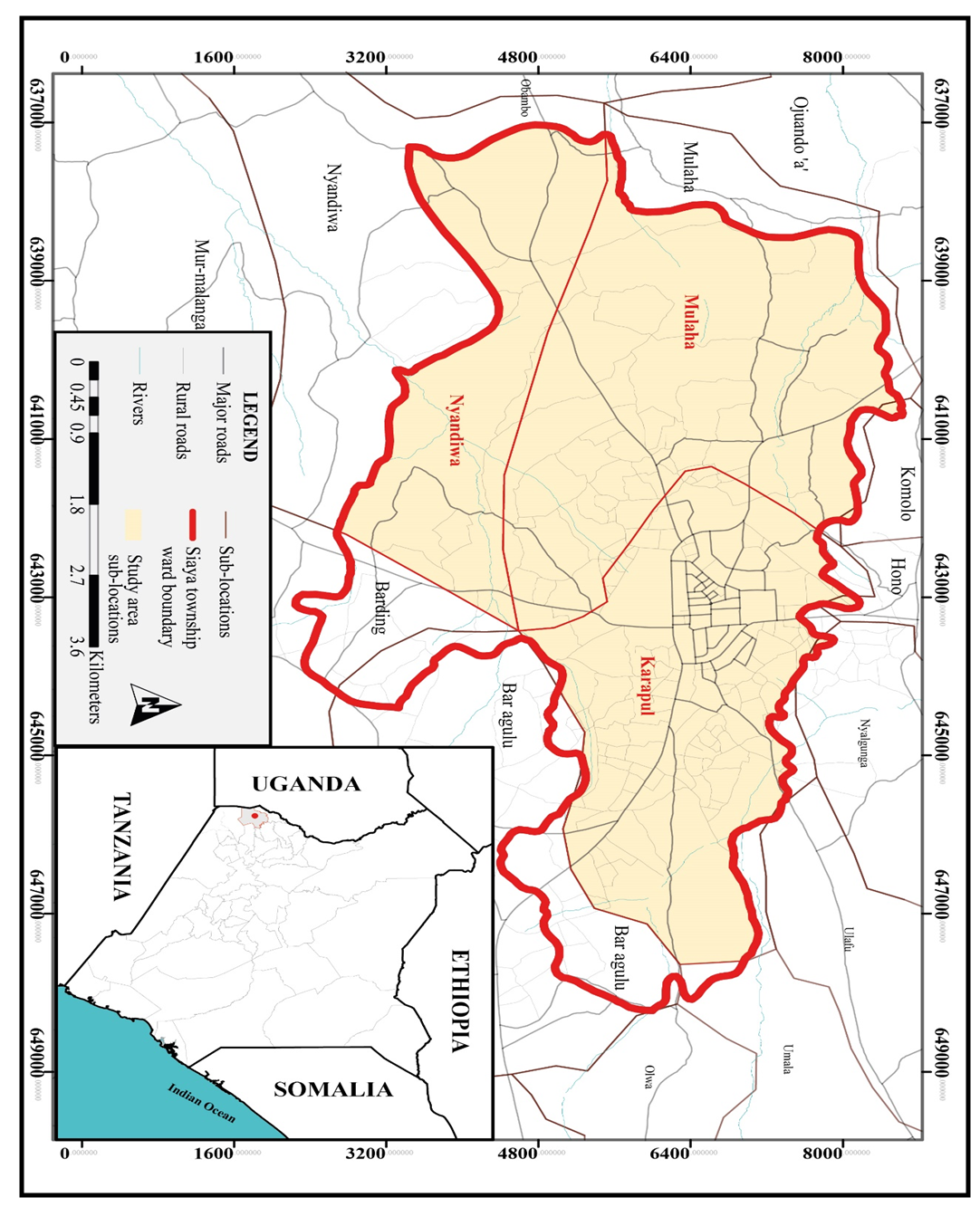 | Figure 1. Study Area |
3.2. Research Design
- This research adopted a cross-sectional survey research design and sought to explain land use change and its implications on spatial stability of peri-urban areas. A cross-section survey captures data to draw predictions about a research problem within a given period (Aggarwal & Ranganathan, 2019) and may be replicated regularly (Lavrakas, 2008). It also allows respondents to explain and document the status of variables and also enables use of both qualitative and quantitative data (Ponto, 2015). This research design also includes questions about what, when and how an occurrence happens (Hammarberg, Kirkman & Lacey, 2016). As such, the study evaluated the effectiveness of planning tools in managing the peri-urban land use change process towards achieving spatial stability.
3.3. Target Population
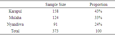
- Asiamah, Mensah and Oteng-Abayie (2017) describe the target population as the populace where findings are extrapolated. It is also the overall compilation of all themes in any area of research (Kothari, 2013). In this study, two kinds of target population were required: sub locations, land parcels, and land parcel owners. The geographical target population comprised all the five peri-urban locations in Siaya Township Ward and 5,443 land parcels, 2,313 in Karapul, 1,805 in Mulaha and 1,325 in Nyandiwa as identified from the Registry Index Maps. Further, the study targeted a total 5,443 land parcel owners in Siaya Township Ward, from which a representative sample was extracted to examine their opinions on the effectiveness of planning system in managing peri-urban land use change process as well as land use change management framework. Yemane (1967) formula was used to calculate sample size.
3.4. Sample Size
- The sample population consisted of all the peri-urban areas and of all parcels in each study sub location, which also comprised the land registration section. The parcels were given an identity number and updated where necessary. A sample size of parcels was then derived from the population size of all parcels in each sub location using Yemane (1967) sample formula at 95% confidence level and a level 0.5% error margin.
 Where: n = the sample size; N = the population size; and e = the confidence level (0.5).
 Therefore; n=373The samples were drawn from each sub location by proportions as indicated in the table 1.
|
3.5. Methods of Data Collection
3.5.1. Questionnaire Administration
- A series of questions were designed and administered for gathering information from respondents. The questionnaires were designed to elicit their knowledge, understandings, experiences and perspectives on peri-urban land use change and the land use change management system. The rationale for using this method in accordance with Mugenda and Mugenda (2003) is because it is easier to evaluate, it offers an instantaneous functional form and is easier to manage by alternate responses whenever possible. Likewise, unstructured questions have the benefit of having more depth of answers. This method was used to collect data about the second objective, “To evaluate the effectiveness of planning system in managing the peri-urban land use change process”. The questionnaire covered aspects on: turnaround time for development applications; criteria for development approvals; site visits and inspection of developments; criteria for approval of building plans; application for development permission; and notice of approval / deferment / refusal of development applications.
3.5.2. Focus Group Discussions and Interviews
- A conventional requirement for focus group study is that there should be at least two groups for each social stratum in the sample (Newcomer, Hatry, & Wholey, 2015). This was based on small groups of not more than eight (8) people each and participants discussed land use change processes and land use change management system in a context where people were allowed to agree or disagree with each other. Land owners, land agents, physical planners and surveyors as well as key informants were interviewed. The study explored a range of opinions and contexts in terms of beliefs, experiences and practices on land use change and the process of management of land use change. Key land agents were interviewed following a snowball approach, starting at focused group discussions where key actors were identified. Interviews were semi structured to allow for other topics emerging during the course of the questioning. County Officials interviewed included: County Director of Physical Planning, County Director of Survey, County Lands Officer, County Works Officer, and Chief Officer Lands. Land Sector Professionals included five Physical Planners in Private practice and seventeen surveyors including a one licensed surveyor. The selection criteria of the participants were purposive based on people of the same profession in the land sector. The Thematic issues discussed included the following: i. Land use change management: What is the peri-urban land use change and development problems that planning should cure? This included forms of spatial instability, land use conflicts issues, land use incongruence, service and utilities provision, sustainable land use practices, cost of planning services planning bureaucracy. Why has it been difficult to solve them?ii. Land use zoning and development control: What caused non-compliance with zoning standards and regulations and how can this be remedied? How should development control in peri urban areas be structured?iii. Development compliance and enforcement: How can land planning ensure orderly and sustainable land use and human settlement?iv. Land Use Change Management Structure: What should be done to make these land processes better in terms of land subdivision, land conversion, land use planning and land use conflict management? how can the government ensure compliance to guarantee spatial stability of peri-urban areas? what would you consider to be the ideal mechanism for peri-urban land use management and why?
3.6. Methods of Data Analysis
3.6.1. Descriptive and Inferential Statistics
- The analysis of data was undertaken as a continuous process throughout the study as described by Mohajan (2018). The actual data analysis was nevertheless done as distinct process in order to apply different techniques of analysis to realize the study objectives. Chi Square Analysis was used in analysing “effectiveness of Land Use Planning and Change Management System” and the corresponding hypothesis that, “There is no significant difference between the prescribed land use planning standards and the applied standards in peri-urban areas of Siaya Township Ward”. The Chi square test is a non-parametric test intended for two main reasons: (a) to test the hypothesis that there is no correlation between two or more categories; (b) and to test how probable the observed data fits the predicted distribution (Rana & Singhal, 2016). Descriptive statistics was used to summarize data set, which represent the entire or a sample of population, and to describe the features of specific data. Tables, matrices percentages and charts were used to summarize or describe the data.Whereas graphic presentations and tabulation were used, the study applied Chi Square to determine if there was a statistically significant variance between the planning standards prescribed in policy and regulations for development control and the standards applied on the ground. It is held in this study that the variance in the planning standards and applied standards represents a spatial instability which manifests itself in land use incongruence, land use conflicts and haphazard developments leading to the spatial deterioration of the peri-urban space. In this case, the chi-square is deemed significant if there is a variance between the two variables,
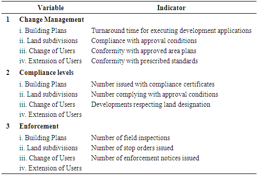
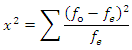 Where fo = the observed frequency And fe = the expected frequency To further evaluate the effectiveness of the land use change management system, the study measures the extent to which planning and development control targets are met using predetermined indicators in land use control regulations, the physical planning standards and the departmental service charter. These indicators measure "how much" or "how many" or “at what rate” or "to what extent" are the compliance with land use change management objectives being met (Dumanski, Gameda & Pieri, 1998). Table 2 summarizes the tools and indicators of measuring effectiveness. Typical measures of effectiveness included turnaround time for development applications, level of compliance and service user’s (parcel owners and land use change agent’s) satisfaction with the system. Further, the study used indirect measures such as the number of visits to sites by enforcement officers, enforcement orders issued, and compliance certificates issued and corroboration from focused groups.
|
3.6.2. Content Analysis
- This is a research technique used in making inferences by identifying information about the effectiveness of planning tools in managing the spatial stability of peri urban land use change process. The method involves observation and narration of phenomena with the intent to describe manifest content of communication (Kapoor, Tamilmani, Rana, Patil, Dwivedi, & Nerur, 2017). The method was used to provide insights on the legal provisions for spatial planning and development control in Siaya town.
4. Results and Discussion
- Planning processes are recognized as important in managing land use change and spatial order. However, weaknesses in the system may impose constraints towards achieving the desired development outcome. The objective of this study was to evaluate the effectiveness of planning tools in managing the peri-urban land use change process towards achieving spatial stability.
4.1. Turnaround Time for Development Applications
- The turnaround time for development applications was used to measure efficiency of the system. Respondents were asked to rate the development application process length and monitoring of compliance. The time taken varied between the technical departments (Figure 2). 52.3% of the respondents said it took them between 21-30 days for Physical Planning Office to grant their comments on application, 22.3% took 11-20 days, 11.7% (31-40 days), 8.3% (1-10 days) and 5.4% (41-50 days). Findings from the Lands office indicated that it took 61.1% of the respondents 31- 40 days to obtain comments, 11.2% (21-30 days), 12.2% (41-50 days), 9.2% (11-20 days), 6.3% (1-10 days). Consequently, 51.2% stated that it took them 31-40 days to obtain comments from the Survey Office, 19.5% (21-30 days), 14.1% (11-20 days), 11.1% (41-50 days) and 4.1% (1-10 days). In the Public Works Office, it took 51.4% of the respondents 31-40 days to obtain development approvals, 17.1% (21-30 days), 13.2% (41-50 days), 10.1% (11-20 days) and 8.2% (1-10 days).
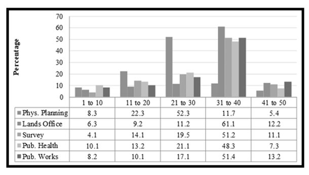 | Figure 2. Length of Time Taken to Process Development Applications |
4.2. Analysis of Criteria for Development Approvals
- Analysis of the criteria for approval of development showed that the most preferred criteria is the land use type at 34.6% followed by plot size at 25.4%, proposed development (19.6%), accessibility (14.1%) and plot shape (6.3%) as depicted in figure 3.
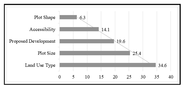 | Figure 3. Criteria for Development Approval |
4.3. Site Visits and Inspection of Developments
- Development inspection is part of monitoring of compliance with the requisite standards and ensures that they adhere to the approval conditions. The study established that there are no scheduled site visits by the technical departments. The Physical Planning and the Works Department both gave reason for this as constrained resources and equipment, especially transport and technical personnel for site inspections.
4.4. Criteria for Approval of Building Plans
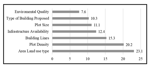
- In terms of approval of building plans, the results show that land use type in the area was the most referred approval condition at 23.1% followed by plot density at 20.2%, building lines (15.3%), infrastructure availability (12.4%), plot size (11.1%), type of building (10.3%) and environmental quality (7.6%) as shown in the figure 4.
 | Figure 4. Criteria for Approval of Building Plans |
4.5. Analysis of Application for Development Permission PPA 1
- The instruments for land use change applied to this study were under the Physical Planning Act Cap 286. The study investigation established that Section A of this form requires general information and particulars of ownership while Section B details land subdivision. 48% of sampled development applications in the County offices were found to have given no description about the nature of subdivision, as they only stated the number of sub-plots e.g., into two portions while 52% did. No narrative is given including the purposes for which the land is to be used despite it being a requirement to state the purpose for which the land and buildings is currently used and intended use. In 52.3% of the sampled applications in section B was indicated as agricultural without further description, even where the acreage of the subplots was smaller than 0.1ha which implied change of use from agricultural to another user. As to whether alternative means of access will be required consequent to the subdivision, 42.6% of the applications indicated not applicable despite being a condition for approval that the roads and drains must be developed to adoptive standards. The study however, revealed that 57.4% of these applications involved creation of new access roads to the sub-plots. Section C of PPA 1 concerns change of user, extension of use and extension of leases. This is the most important section to land use change and spatial transformation in peri-urban areas. Here the requirement is to state whether the change of use involves land subdivision and if permission was sought. The exact nature of change and a description of the proposed development is required including the purpose for which land and buildings are currently being used; and whether construction of new roads is required and service requirements such as water supply, sewerage, waste disposal and surface water drainage. Generally, the application for development authorization must include a concise explanation of the development to which it relates. This includes a change of use, extension of use/lease, amalgamation and subdivision; a definition of the location of the property; and an architectural and survey plan that describes the land; and an indication of the location of the land in relation to other projects.Analysis of the sampled forms revealed that 59.7% stated purpose as residential without further description, 28.2% indicated not applicable for the requirement as to whether alternative means of access is required and 12.1% indicated not applicable as to the requirement on the method of water supply sewerage disposal and solid waste disposal. The study noted that form PPA I was principally an application for permission to develop land and or buildings. However, the instrument does not have a section dealing specifically with building development permission. This creates disconnect between land subdivision, change of use and building development permission. 68.4% of developments sampled were found to have been built on land that was a result of subdivision and change of use while 31.6% did not undergo this process. A planning brief is a requirement for subdivisions and change of use. It illustrates how the proposed change is compatible with adjacent properties and the area relative to the proposed development. It is expected to describe the development proposal accurately and provide details of all the developments proposed. Findings indicated that only 9.2% of building plans were accompanied by planning briefs while 90.8% didn’t. Consequently, 26.7% of land subdivision schemes sampled were accompanied by planning brief while 73.3% didn’t. On the content of the planning briefs, 63.2% of the applications dwelt mainly on analysis of accessibility and environmental conditions for the proposed development but are conspicuously silent on relationship of the proposed change or development to its neighborhood in terms of land use compatibility and spatial congruence, as well as its impact on the spatial integrity of land and its abutment. Form PPA1 is replaced by PLUPA1 in the new Physical and Land Use Planning Act (2019). The irony is that PLUPA 1 has not improved on the objects and weaknesses of PPA1. The PLUPA1 is shorter but more generalized, it only requires the applicant to state the nature of the project and to indicate type of development permission sought, then to indicate the national sectoral legislative and policy framework the project will operate under. These are generalized statements and do not serve to describe with certainty the nature and potential impact of the project and its relationship with existing or proposed or approved developments and planning of the area. Nothing in the instruments dedicates to the peri-urban area.
4.6. Land Use Planning Control Standards
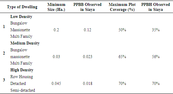
- For Siaya Municipality, the study established that residential developments were the major land use in the built-up peri-urban areas. The percentage coverage of land for residential developments in the surveyed areas comprise 70% of the developed and occupied land. The Physical Planning Handbook (2007) recommended minimum standards for various types of development classes. The study observed that actual developments were at variance with the prescribed standards as in the Physical Planning Handbook.a. Minimum Plot SizesFor residential developments of different types, the handbook recommended various standards. These standards are compared with the observed average minimums from the field survey as presented in Table 3. The planning handbook has fixed minimum plot areas and plot coverage to prevent over-crowding and facilitate easy movement.
|
|
|
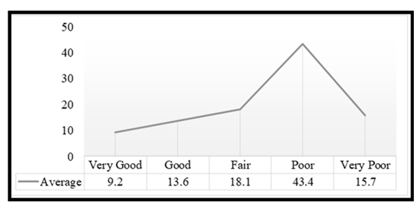 | Figure 5. Service Provision by the Land Use Change Management System |
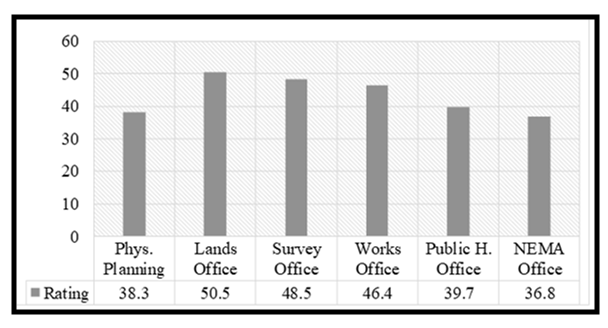 | Figure 6. Satisfaction with Service Delivery by Technical Departments |
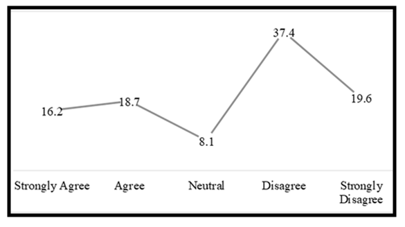 | Figure 7. Instruments Used for Land Use Change Management |
4.7. Test of Hypothesis
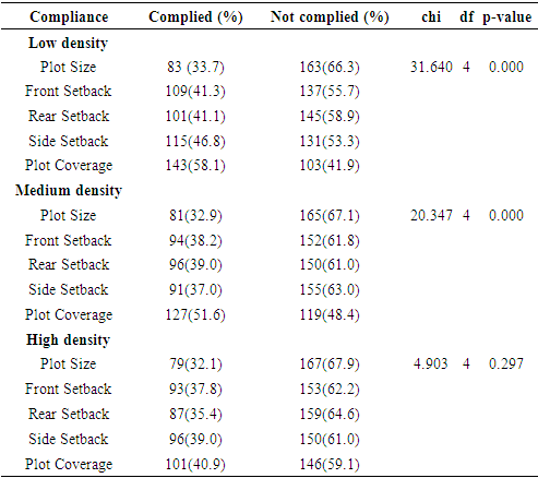
- The Physical Planning Handbook (2007) prescribes standards for developments especially building developments within different development zones. The handbook has fixed minimum plot areas and plot coverage to prevent over-crowding and facilitate easy movement, minimum building setbacks, minimum frontages and rear setbacks all to ensure appropriate relative development location and allowance for circulation and provision of on-site utility services. For Siaya Township Ward, the study established that residential developments were the major land use in the built-up peri-urban areas. The study surveyed 246 buildings with approved development plans out of 497 to assess the level of compliance. It observed that actual developments were at variance with the prescribed standards in the Physical Planning Handbook. Whereas compliance with plot coverages was the most observed, on the other hand compliance with minimum plot sizes for the different types of development categories was the most violated.
4.7.1. Chi-Square Test
- Regarding the effectiveness of the land use change management system, the following indicators were measured; (1) compliance with prescribed development standards. The independent variable represented prescribed planning standards for approval of development and land use change while the dependent variable represents the standards measured or applied on actual developments; and (2) the turnaround time for development applications, where the independent variable was represented by the time service charter. The Chi Square test was performed to determine if there is a significant association between the prescribed compliance standards and the applied standards. The null hypothesis is that there is no significant association in the compliance levels between prescribed and applied standards. Table 6 shows the results of the Chi square test which demonstrates that despite there being a clear manifest variance in the difference between prescribed standards and applied standards of development compliance, there is no significant association in the categories of low-density developments and the medium density residential development category. However, in the high-density residential category, the test results show a strong association hence, the null hypothesis is rejected.
|
4.8. Discussion of Results
- The study established low level of compliance to development standards. This implies that high number of developments are taking place without conformity with prescribed development conditions and are therefore incongruent. This was in agreement with the findings of Omollo (2018) who established noncompliance of developments to approved development control regulations and plans in Kisii town which was justified by spatial variations in commercial land use (65.73%), residential land use (39.73%), and educational, (17.78%). This according to Samburu, Hayombe and Owino (2019) is a result of ineffective enforcement and land use regulations which are rarely implemented. The study noted a lack of standardization of the service charter and standards to be interrogated by each technical department on the various types of development applications. Besides, the turnaround time on development applications was not regulated by a common service charter. This rendered the approval process and the system open ended and subject to discretion and therefore ineffective. According to Thomassen, Ahaus, Walle and Nabitz (2012) this compromises customer satisfaction and quality of public service delivery. This was confirmed by the service consumer’s perception that the land use planning system on managing this land use change was generally ineffective. The summation of ineffectiveness of the land use planning system was measured by the opinion of land use change agents on the quality as measured by the turnaround time of service offered by land use change management system and on approval of the service delivery process. Opinion of land use change agents was that the ineffective land use change management process is responsible for peri-urban spatial instability. This agrees with the findings of Adam (2020) who established that poor land use change management resulted into rapid and uncontrolled built-up properties in Peri-urban areas of Ethiopia occasioned competition for land between agriculture and bult-up properties. However, Surya, Ahmad, Sakti and Sahban (2020) indicated that formal and informal drivers of land use change management impact greatly on peri-urban land conversions and thus, this can be sorted by strengthening capacity for development control. Though perceptions of people are often relative, they are usually indicative of what is on the ground. Contrary to government policy to ensure planned land use change and spatial stability, the local people had a negative view about the effectiveness of the land use planning system in managing land use change process towards spatial stability (Samburu, Hayombe & Owino, 2019). The results of this study would be helpful to plan and implement important management strategies that establish effective land use planning system for peri-urban areas. Overall, this analysis concludes that policymakers, planning practitioners and researchers will have better understanding of the causal linkages between land use planning management system and ultimate on-the-ground land use outcomes. The study finds that land use change management instruments (the PPA and PLUPA forms) have a discernible weakness on impact positively on the expected land use outcomes. What’s more, the frameworks used to assess land use and development control largely emphasize planning process and does not address implementation or outcomes.
5. Summary of Findings
- The study established that it took an average of 31-40 days for development applications to be processed by the various County Departments. This was a result of disconnect between the technical departments. The study noted a lack of standardization of the service charter and the standards by each department on the various types of applications. In terms of development approvals, the study established that land use types influenced decisions by 34.6%, plot size (25.4%), proposed development (19.6%), accessibility (14.1%) and plot shape (6.3%). Consequently, the study noted lack of scheduled site visits by the technical departments. In terms of approval of building plans, the results show that land use type influenced approval by 23.1% followed by plot density at 20.2%, building lines (15.3%), infrastructure availability (12.4%), plot size (11.1%), type of building (10.3%) and environmental quality (7.6%). Further, findings indicated that only 9.2% of building plans were accompanied by planning briefs while 90.8% didn’t. Consequently, 26.7% of land subdivision schemes sampled were accompanied by planning briefs while 73.3% did not. On the content of the planning briefs, 63.2% of the applications dwelt mainly on analysis of accessibility and environmental conditions for the proposed development but are conspicuously silent on relationship of the proposed change or development to its neighborhood in terms of land use compatibility and spatial congruence, as well as its impact on the spatial integrity of land and its abutment. Regarding compliance with minimum plot coverage, the study found that 32.4% developments in Karapul Ramba had compliance, followed by Hono 25.2% and Mulaha 23.2% and Nyandiwa at 16.2%. Further, 43.4% of the respondents rated the service provision as poor, citing unclear procedures, the lengthy processes, indeterminate time frame and low acceptance from these institutions as the main challenges while 43% didn’t know. Only 13.6% rated the service as good. Thus, it is suggested in this study that with appropriate planning and institutional framework, it is possible to manage and direct peri-urban land use change to a desirable spatial state.
6. Conclusions
- The study found that urban development plans have not been effective instruments for control and guidance of the development of peri-urban places. This necessitates the rethinking of urban planning concepts that have shaped the understanding of the peri-urban development. This study argues that the land use change and the spatial restructuring of peri-urban places will be the most critical because there is no planning system or institutional frameworks to manage the transformational processes towards spatial stability.