-
Paper Information
- Previous Paper
- Paper Submission
-
Journal Information
- About This Journal
- Editorial Board
- Current Issue
- Archive
- Author Guidelines
- Contact Us
Architecture Research
p-ISSN: 2168-507X e-ISSN: 2168-5088
2020; 10(4): 109-116
doi:10.5923/j.arch.20201004.03
Received: Oct. 7, 2020; Accepted: Nov. 10, 2020; Published: Nov. 28, 2020

Rethinking Urban Waterfront: A Case Study of Sylhet City Bangladesh
 Abstract
 Reference
 Full-Text PDF
 Full-text HTML
Tanjima Siddika
Leading University, Sylhet
Correspondence to: Tanjima Siddika, Leading University, Sylhet.
| Email: |  |
Copyright © 2020 The Author(s). Published by Scientific & Academic Publishing.
This work is licensed under the Creative Commons Attribution International License (CC BY).
http://creativecommons.org/licenses/by/4.0/

A city with an urban waterfront may be considered a great resource for environmental and social benefit. Urban waterfront can open up the scope for public recreation and socialization among city people. While most of the developed cities are trying to revitalize the waterfront after the post-industrial period, in Bangladesh, the waterfront is a place of great negligence and remains underdeveloped. In most cases, the waterfront is being encroached illegally for large-scale development such as the industry and warehouse. In Sylhet, the city is divided by Surma River, and the waterfront area of the north side of the river is mostly occupied by the old wholesale market, small industry, and warehouse. The Sylhet city corporations are planning to develop the southern part under a guideline and they already had prepared a primary zoning plan for the waterfront area. Surely, for comprehensive and sustainable development, the knowledge of urban design should be placed in the current context that may enlighten some issues like economic and social benefit, physical and cultural development of the context. This paper aims to understand the morphology of the waterfront area and develop a spatial framework for the proposed zoning area planned by Sylhet City Corporation. A comprehensive field survey and observation survey will be conducted to develop morphological analysis and will conduct case study research to develop some strategies for a spatial framework.
Keywords: Urban Waterfront, Post-Industrial, Under Develop, Sustainable Development, Morphology
Cite this paper: Tanjima Siddika, Rethinking Urban Waterfront: A Case Study of Sylhet City Bangladesh, Architecture Research, Vol. 10 No. 4, 2020, pp. 109-116. doi: 10.5923/j.arch.20201004.03.
Article Outline
1. Introduction
- Now a day, the city is confronted by several challenges due to rapid urbanization and the great migration to the city. In such a case city is need to fulfill the challenges like reused the urban spaces and lost space, efficient and multiple uses of urban floors and space, compacting urban structure to accommodate a large population, and ensure mobility. The urban waterfront is a challenging space for the planner and urban designers to be acquainted the city itself with the global world and fulfill local urban needs. The urban waterfront is one of the special structures of the city which may hold ecological resources, economical benefit, and scope for socialization and recreation for city people. ‘It enlivens and structures urban spaces, without creating spatial borders. It enhances the value of urban spaces and can define a certain image in people’s mind maps’ (Niemann, B., & Werner, T., 2016). The unique spatial morphology of waterfront due to various changes of uses from pre-industrial age to current days waves human settlement of the particular area. These morphological changes interrupted the relation between waterfront and cities (Pekin, U., 2008) that might emerged waterfront regeneration policy (Timur, U. P., 2013). Like other cities of Bangladesh Sylhet is also a riverine city. The river Surma dived the city into two parts where the northern part is comparatively urbanized rather than the other one. Being an organic city waterfront area is occupied with a wholesale business, warehouse, and some administrative in the northern side. Under the master plan of Sylhet divisional town 2010-2030, waterfront areas are outlined with recreational and commercial land use mostly. But it is quite impervious to implement the desire land use based on an outline zoning plan which is more a quantitative approach without understanding the quality of urban space, the morphology of the area, standard and guidelines of waterfront development, and urban design principles and technique. This aims to prepare a strategic framework for the new waterfront of Sylhet by analyses its current situation, maintain the standard and guidelines of waterfront development, and other social and cultural issues.
2. Literature Study
2.1. Definition of Waterfront
- Urban waterfront can be defined as a particular space of the city which is physically attached to river or water sources. (Niemann, B., & Werner, T., 2016) quoted researches as “part of a town that is next to an area of water such as a river or the sea” (Hussein, R.M.R., 2014) and therefore as “the interface between land and water” (Giovinazzi, O. & Moretti, M., 2010) or paraphrase the waterfront as “space for interaction between two different systems – land and water” (Giovinazzi, O. & Moretti, M., 2010). The following has to be recognized: researchers stated“the waterfront should not be simply considered as a line, but should be more correctly envisaged as a network of places, functions, additions, and hinges between the coast and the city, between the port and urban activities” (Giovinazzo, O. & Giovinazzi, S., 2008). (Yasin et al. 2010) specified that waterfront is defined generally as the space of contact between urban development and the water. (Hou, 2009), described the waterfront area as the conflux area of water and land.According to (Wrenn et al., 1983), urban waterfronts could be characterized by five different ways according to a location with water. a. Urban area located on the peninsula, b. An urban area located on a bay, c. An urban area located on banks of a river, d. An urban area located on banks of intersecting rivers, e. An urban area is located on a large body of water.
2.2. Historical Development of Urban Waterfront
- The morphology of urban waterfront had significantly changed due to the social, economic, and political needs of human beings. Throughout history, the waterfront was the first place of choice to live in due to the comfort and security of food, transportation facilities, and the scope of cultivation. Therefore many cities developed beside the waterfront (Hamamcıoğlu, 2005; Morena 2011). In the beginning, the settlement was directly connected with the nature and landscape of the waterfront which established a special landscape culture between water, settlement, and human. But the industrial revolution during the 19th century shaped the waterfront as a place of large warehouse and mills rather than identically created an obstacle between city and waterfront (Kristiánová, K., 2018). Throughout the middle of the 20th century (Carlino & Saiz, 2008), many industrial events and port facilities in city centers relocated to outside and left vast urban lands especially along waterfronts after the decline of old harbor sites (Gospodini, 2001). (Shangi, Z. A. D., Hasan, M. T. 2019) stated ‘due to rapid construction and population pressure in the inner city, the barrier between city and suburb dissolved that interconnected city people with natural landscape again but waterfront remain untouched due to flood threat’. The new technique in the construction industry urged to redevelop waterfront for social, recreation benefits for city people and create a global image.
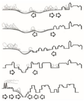 | Figure 1. Spatial relation between city and waterfront. Source: (Hradilová, I., 2013) |
2.3. Sustainable Development of Urban Waterfront
- However, the term sustainable or sustainability is sophisticated to discuss nowadays but could state according to “Brundtland-Report” which was published by the Norwegian prime minister Gro Harlem Brundtland 1987 and the World Commission for Environment and Development of the United Nations in 1987 as “Sustainable development is a development that meets the needs of the present without compromising the ability of future generations to meet their own needs.” Besides promoting consciousness of the current environmental threats the conception of sustainable development denotes a standard of action that attempts to associate ecological, economic, and social objectives (Gauzin-Müller, D., 2002). Sustainable urban development of waterfront should enliven the city inhabitant and improve their lifestyle from a social, economic, and ecological perspective. According to Toronto Waterfront Revitalization Cooperation, Sustainability Framework a sustainable waterfront 2005 is “a place where people from all backgrounds and ages can live, work, play, visit, and learn in a way that strengthens and celebrates the beauty, the diversity, the economic vitality, the opportunities, the creativity, the heritage, and the natural environment of the city”.
2.4. Principles of Waterfront Planning and Design
- The prime criteria for designing waterfront are to protect and ensure environmental safety and sustainability. Since the water and waterfront are part of the global ecosystem, it should be the major concern to enhance the ecosystem and preserve the existing resources (Niemann, B., & Werner, T. 2016). The new waterfront has to be understood as an integral part of a city’s urban structure (Giovinazzi, O. & Moretti, M., 2010). The waterfront cannot be a competitor of the city, but it has to complete the urban structure and the other way around. At the same time, it is necessary to unite the existing urban heritage and new development (Hussein, R.M.R., 2014). The land distribution between private and public sectors along the waterfront is a significant criterion for the sustainable waterfront. ‘According to the Waterfront Center, the private development is a necessary component of the waterfront renaissance process that should fit within the community’s vision, not override it’ on the other hand excessive privatization may distract public access for a lifetime along the waterfront (Grau, D. & Keke, Z.C., 2018).The waterfront development should consist of a diversity of cultural, social, and commercial facilities as well as a variety of living concepts which will attract different types of user to the waterfront (Niemann, B., & Werner, T., 2016).Considering as global link and front yard to the world, the waterfront is a scope to reflect the unique character of the community and local distinctiveness (Grau. D & Keke. Z.C., 2018). The waterfront could be the identity of the country to the world by reflecting its culture and other social dynamism. Besides all the above issues the water edge is a place of great interest for various stakeholders including port authority, maritime planner, ecologist and environmentalist, public authority, private housing, business hub, and political groups. Therefore their views should be reconciled before any sort of intervention.
3. Methodology
- A literature review has perused to describe the development of the theoretical and conceptual framework of urban waterfront with the perspective of urban design and planning strategies. The review also focused on the waterfront development principle based on social, political, economic, and other contextual aspects. Besides, the literature includes the issues to develop any waterfront from a sustainable perspective derived by the international organization. Also, comprehensive literature a morphological analysis will be conducted in the study area to understand the existing land use, network, open space, and other spatial information in an urban design mapping process. Both spatial and theoretical understanding will try to generate some major strategies for the new waterfront development of Sylhet.Location of the action area: the study area is located partially in 25 and 26 no ward under Sylhet City Corporation on the southern bank of Surma River. Gotatikaor BSCIC industrial area, New Administrative Zone, Kean Bridge, Railway Station, and Kadamtoli bus terminal are near to the study area.
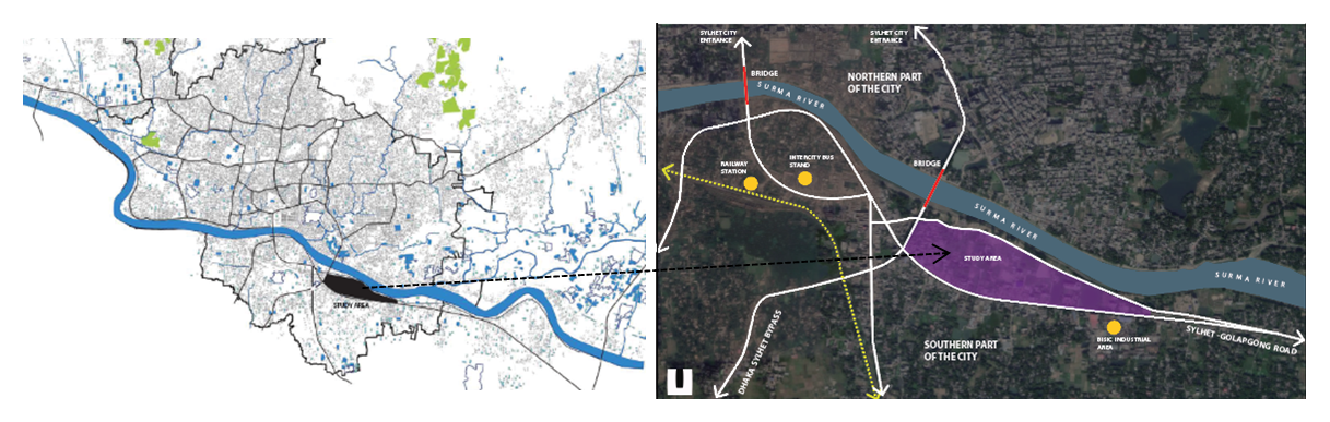 | Figure 2. Location of the study area, Source: Google map modified by author |
4. Result and Discussion
4.1. Morphological Analysis of Study Area
4.1.1. Land Use
- Predominantly, the study area is composed of residential land use, and the Commercial area is mainly located beside the major roads. Incipient administrative zone and BSCIC are the potential land use of the study area. Adjacent to all other land uses, the study area is also holding much vacant land along the waterfront area. The area can be defined as the city edge where the land use for transit and transport is playing a significant role currently. Therefore, some legal and illegal parking with a workshop for a motor vehicle can be easily traced.
4.1.2. Amenities
- Though the area is not well developed yet but well composed with some vital amenities facilities like a fire service station, petrol pump, and water transit (Ghat) and some elementary facilities for the neighborhood. Contiguous to the mundane facilities there are some paramount public administrative offices as passport, divisional office and an industrial area are located proximate to the area (fig 03).
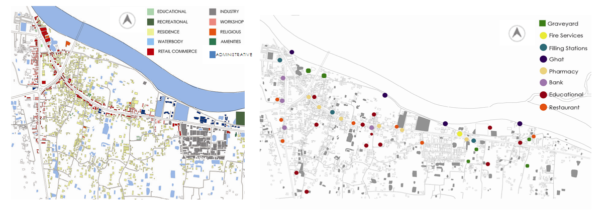 | Figure 3. Land use and amenity facilities map, Source: Author |
4.1.3. Transit and Road Network
- The study area can be considered as a prospective center for Sylhet city in terms of the local and cross country network. The area ties with India by the Sylhet-Tamabil highway and also connected with other districts locally (fig 04). Locating in the city edge, highways are bulging the spatial structure of the area. Slow development resulted in insufficient and poor road networks at the community level that promoted dead end and large scale blocks. Besides, some important transits like railway station, City Bus Terminal, local River Port (ghat) are also in 5km distance from the study area.
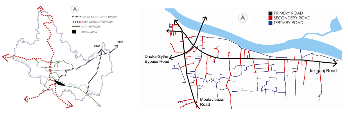 | Figure 4. Regional and city scale road network, Source: Author |
4.1.4. Green Blue Network
- Compare to the southern part of the waterfront the northern part has more vacant space which is yet to develop. While the study area contains a large open space footprint but not in use for public service or recreation like a park, playfield, etc. In (fig 05) the map shows an organic composition of open space around the study area that may potential to build a strong open space network to the waterfront. Moreover, the water bodies are commencing the ecological value corresponding with open space. The underutilized land and water body could be a good opportunity to establish a new city center.
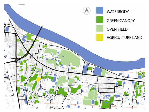 | Figure 5. Existing open space diagram |
4.2. Findings from the Morphological Study
- The above analysis of the study area concludes with some scope and threats to urban design exercise. A plentiful amount of land supply is one of the major criteria for urban design which is present in this area. Since some major road network runs through the area but lacks secondary and tertiary road connection is quite evident. Highways are the major challenge for urban design intervention to create a smooth walkable neighborhood. Existing unused open space could be potentially used for public recreation along the waterfront zone and turn into other land use. The area is well equipped with road infrastructure, major transit, and some important administrative land use which can prompt the area to build out as another city center for the southern part of the city.
4.3. Critical Observation on Theoretical Study
- The theoretical study of the research sums up the waterfront as a significant urban structure for the city. Waterfront has been changed its morphology over time through the historic timeline and created a unique relationship with the city and people. Somewhere the social life is motivated and sometimes the economy is greatly influenced by the waterfront. The researcher identified major gaps between city and waterfront and urged to revitalize waterfront by integrating city linkage and promoting social activities. The understanding of sustainable waterfront focuses on social, economic, and ecological development. Waterfront as a part of the global ecosystem and identity of local individuality should be regarded as a robust space for the city people. A strategic guideline has been practiced in various countries for waterfront development base on environmental benefit, preservation of local heritage and landscape, exposure of indigenous culture, placemaking, accessibility, and other urban design issues.
4.4. Overview of Proposed Outline Zoning Plan
- In the Master Plan for Sylhet Divisional Town 2010-2030, the study area was proposed as a commercial and mixed-use zone. But there is no proposal for public open space or cultural spaces that may significantly turn the space into a private zone (fig 06). The privatization of the space reduces public access. The proposed masterplan is an outline zoning plan where accessibility, network, open space strategy is not well defined.
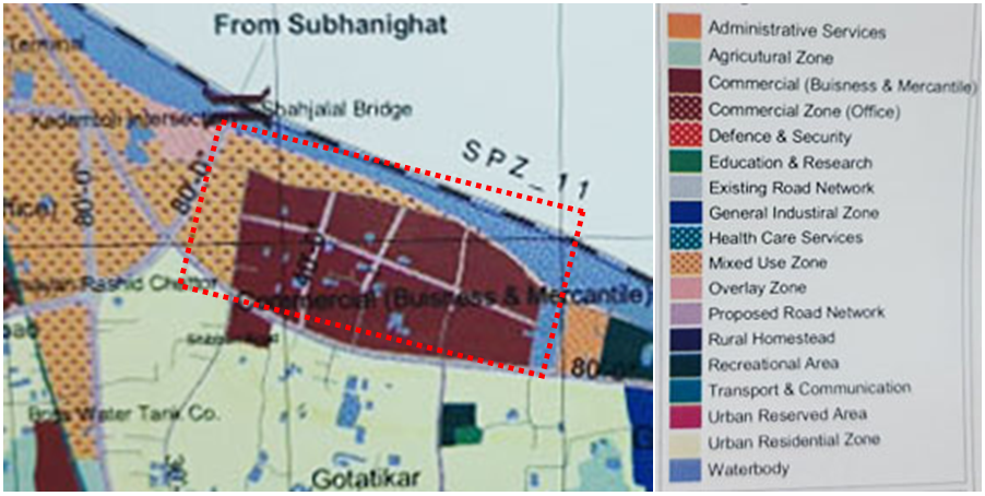 | Figure 6. Proposed outline zoning plan, Source: Master Plan for Sylhet Divisional Town 2010-2030 |
5. Recommendations
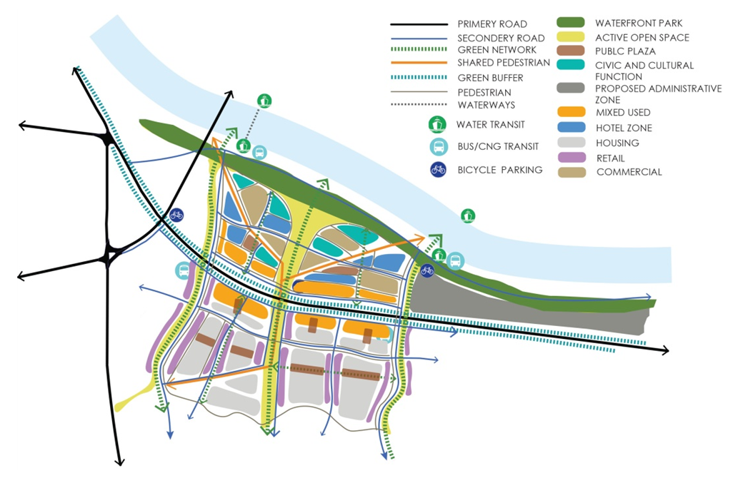
- • Improving permeability to the waterfront: To ensure accessibility, it is important to extend the road network to the waterfront and connect the dead endpoint. Promoting pedestrian along the vehicular street is fundamental owing to create a walkable district. Besides physical linkage, a green network with a pedestrian will add a new dimension (fig 07).• Integrating all the transit and endorsing bicycle track: All the road and pedestrian networks should integrate with the existing transit system. By integrating transit and network may increase the efficiency of public mobility (fig 08). The integration may reduce traffic congestion and other public hazards. Promoting bicycle routes along the waterfront and bicycle park could discourage from use of a motorized vehicle. • Defining urban blocks and introducing public open space: the proposed network will help to divide the large urban block into a smaller size which is easier to reach by walk and increase the opportunity of a variety of space. Public open space is another fundamental need for sustainable development. Various open spaces can be proposed like Waterfront Park, active open space, public plaza, and also some green network (fig 09). Green open space, green lawn, garden as an interface of city and water may generate biodiversity and enrich ecological benefits. The shared pedestrian is also a good practice nowadays which permits motorized and non- motorized way of mobility according to needs.• The mix of different use: As a potential site, the development should focus on local and international stakeholders which can be achieved by diverse use of land. Diversity of land use promote different stakeholder and enhance land value. It is also a good opportunity to promote tourism in Sylhet by creating a tourist hub. Besides that, retail commerce, hotel and office, and some housing can also be proposed. Establishing near to transport hub o the city the study area could accommodate some ranked and boutique hotels and also other services to increase tourism. As a potential public space waterfront is the place to melt multicultural and expose local culture. Civic amenities and cultural exposition facilities could be valuable land use for the waterfront as seen in fig 10.• Community Participation: A lot of waterfront projects are determined by a top-down approach where local community engagement is quite absent. However, this participation can often not be called active citizenship. Though the public is mostly informed but not involved: active participation and involvement of the local community in the development process can make the project more sustainable.
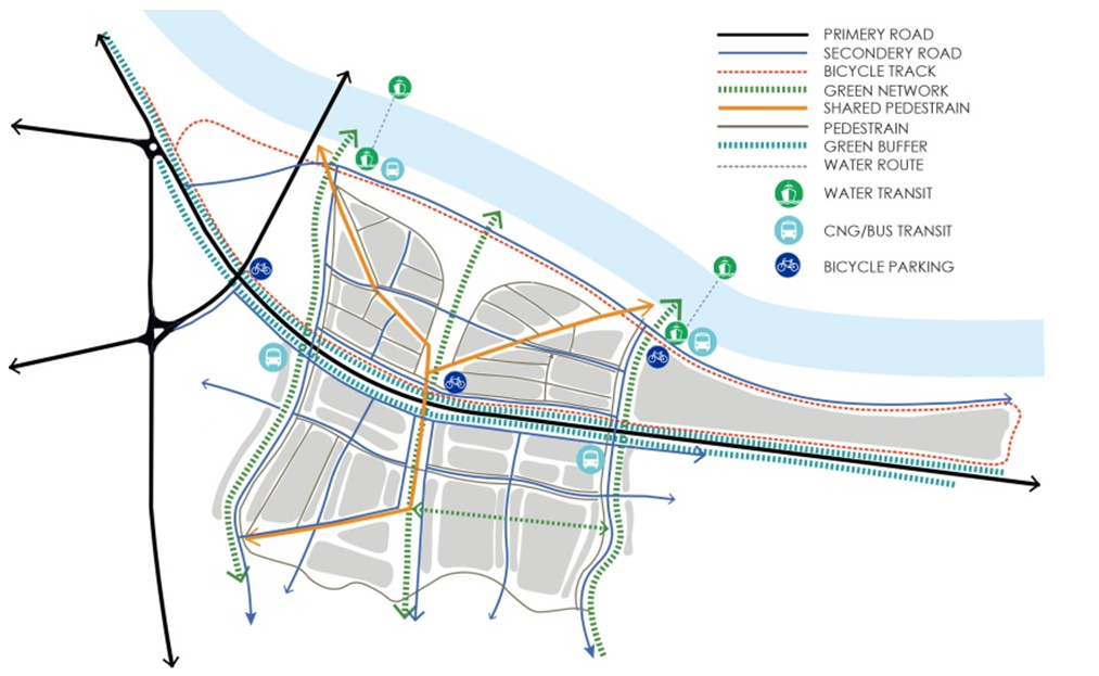 | Figure 7. Conceptual framework of accessibility and transit |
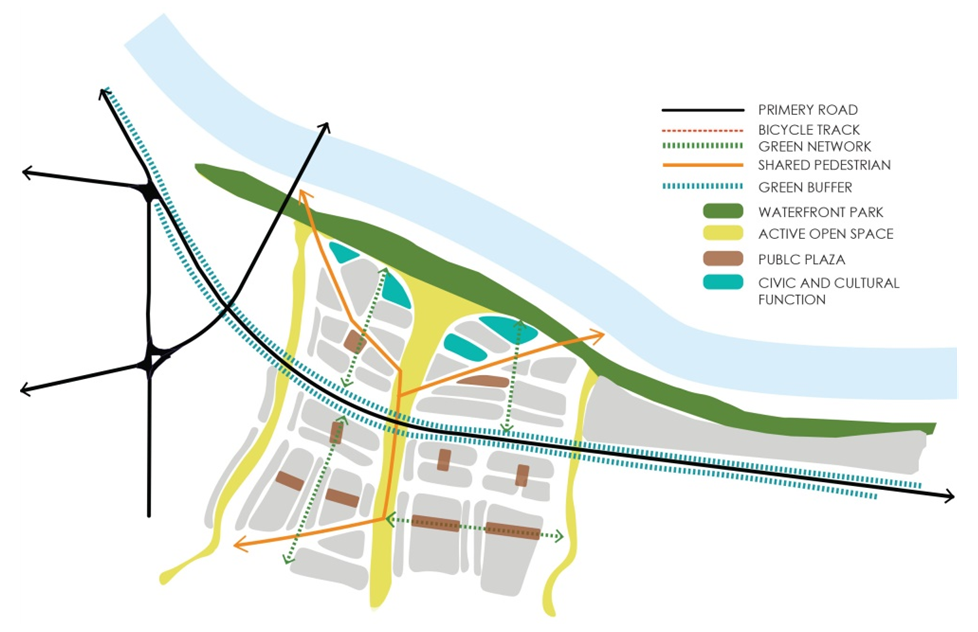 | Figure 8. Proposed open space network and urban block |
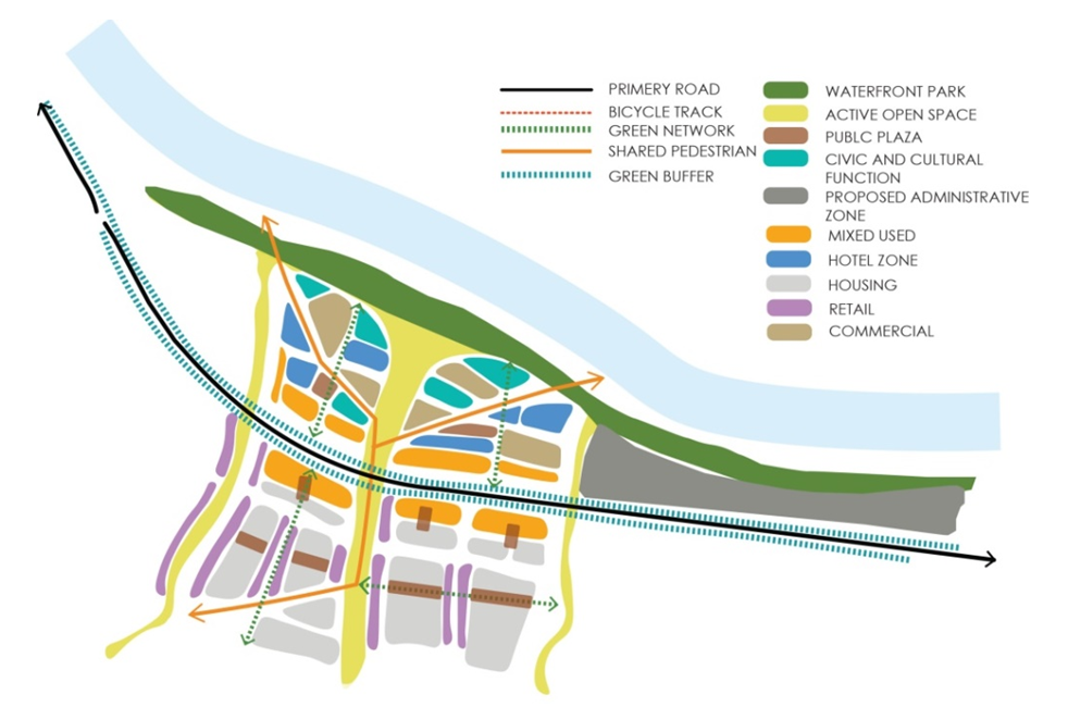 | Figure 9. Proposed land use framework |
 | Figure 10. Conceptual design framework |
6. Conclusions
- The study highlighted a revitalization approach of surma river waterfront in sylhet. The excersice completed a detail field survey of the study area to collect the image og existing condition according to classical principale of urban design. The case study area is hypothetically revitalized by increasing the provision of accessibility, vitality, land use, green corridor, open space and other attributes. The study outcome with a comprehensive urban design framework to create waterfront front more vibrant and sustainable.