Zannat Ara Dilshad Shangi1, Mohammad Tanvir Hasan1, Md. Imtiaz Ahmad2
1Department of Architecture, Shahjalal University of Science and Technology, Sylhet, Bangladesh
2Department of Architecture, Leading University, Sylhet, Bangladesh
Correspondence to: Zannat Ara Dilshad Shangi, Department of Architecture, Shahjalal University of Science and Technology, Sylhet, Bangladesh.
| Email: |  |
Copyright © 2020 The Author(s). Published by Scientific & Academic Publishing.
This work is licensed under the Creative Commons Attribution International License (CC BY).
http://creativecommons.org/licenses/by/4.0/

Abstract
Waterfront is a great natural resource for the urban dwellers to get the recreational and economic benefit. The increase in economic value, leisure, public health and tourism sector has created an opportunity to rethink the waterfront area. Sylhet city divided by the Surma River is an example of declining waterfront while there is hardly any public space for recreational benefit inside the whole city. Naturally, the river has divided the city into two parts lined with two different urban edges. This separation has identically changed the urban morphology in two banks. However, the city corporation authority took initiative to make waterfront aesthetically pleasing rather than constructing a comprehensive plan in order to build responsive public open space. This paper examines the current physical condition as accessibility, transport and transit, land use, public activity and variety of function surrounding waterfront in order to identify the reason of waterfront degradation. As a qualitative research, the observation survey will be conducted to understand the physical condition of the study area. The research will conclude with the scope of strategic urban design guidelines to generate an economically enrich, socially logical and publicly vibrant urban waterfront.
Keywords:
Waterfront, Recreational benefit, Urban morphology, Responsive environment, Public open space
Cite this paper: Zannat Ara Dilshad Shangi, Mohammad Tanvir Hasan, Md. Imtiaz Ahmad, Rethinking Urban Waterfront as a Potential Public Open Space: Interpretative Framework of Surma Waterfront, Architecture Research, Vol. 10 No. 3, 2020, pp. 69-74. doi: 10.5923/j.arch.20201003.01.
1. Introduction
Civilization started from water edge due to cultivation of land and constant water supply. Thus the rivers became a fundamental element of urban structure for ancient civilization from where city started to grow; as in [1]. In European cities, initially, the success of the city was based on a potential waterway system that ensured goods, service and information transportation from one place to another. Ports, large warehouses and industries in the waterfront had been existed during the industrial revolution but de-industrialization made the scenario different; whole waterfront became obsolete. Since last few decades it is trying to regenerate urban waterfront for public use; as in [2]. In Bangladesh, often the land for the human settlement is offered by the river due to its geological context. Here, river is not only a part of natural landscape but one of the moderators of social, cultural and spiritual identity of people. In the past, cities were well connected by waterways for transportation of human, goods and other services. But waterfront is neglected and abandoned now a days due to the change in urban transportation system. In spite of that waterfront holds a great significance over city life in current trend of rapid urbanization by creating scope for public recreation, health benefit, tourism economy and natural landmark. Sylhet, the north-eastern city of Bangladesh is stretched on both the bank of river Surma where the urban centre is located in the northern part of the city. Apparently, the southern waterfront area is more vulnerable and unplanned which results a physical difference between both banks of Surma. Since last decades, the importance of the water system has decreased due to siltation on the mouth of Surma River. Currently waterfront of Surma is poorly managed and remain unplanned that severely hinder public access, place for recreation and attraction of tourist. The research focuses on the major factors responsible for expanding neglected space in waterfront, identification of current land use, accessibility, variety and other dimension of urban design tools of both side of the waterfront. An area near Keane Bridge has been selected for conducting the research which concludes with the proposal of developing public open spaces in waterfront area of Sylhet city by using urban design tools and theory.
2. Literature Review
2.1. Understanding of Waterfront and Urban Waterfront
According to Oxford American Dictionary the meaning of waterfront is described as “the part of a town or city adjoining a river, lake and harbour, etc.”; as in [3]. In [4], waterfront is defined generally as the area of interaction between urban development and the water. The waterfront area is described as the conflux area of water and land; as in [5].“Waterfront can be defined as piece of land or a part of a town next to an area of water and borders a body of water. The urban waterfront could include any urban area that overlooks or adjacent to a river, sea, lake, canal or an artificial water body. Vibrant public waterfronts represent the signature of a great city. Cities all over the world, which are blessed with ocean or bay views, have learned one principle: the greater the publics access, the more valuable their harbor areas become”; as in [1].
2.2. Urban Morphology and Waterfront: A Historical Perspective
Water has motivated the physical development of human settlement since ancient period. The human settlement followed the historical and natural process. There was no steady settlement until humans were capable of growing food for them and domestic animal. The river firstly offered a comfortable condition for steady settlement and thus the human civilization appeared beside watercourse. Later, the threat of flood kept the physical settlement beyond the flood line and made a distance from river belt until middle age when again bringing water become necessary for safety of the town and acted as a fortification element. At that time the extensive development of craft brought the water to mill houses. Though, raceways invented shortly after that period which carried water from river to deep cities.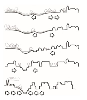 | Figure 1. Relationship between river and city; Source: As in [2] |
“Until 19th century the waterfront maintained naturally; wider embankment, sediment loads, and island were typical. The relation between city and waterfront was intense but industrial revolution during 19th century formed water embankment as a place of large warehouse and mills rather than identically created an obstacle between city and waterfront.”; as in [6]. “Due to rapid construction and population pressure in inner city, the barrier between city and suburb dissolved that interconnected city people with natural landscape but waterfront remained untouched due to flood threat. The planning for new development on the waterfront started while the land price was growing rapidly in the inner city. New construction technology was used to protect embankment that offered a new skyline for city edge and vibrant public space with all attraction of social life in the waterfront”; as in [2].
2.3. Waterfront as Public Open Space
Urban open space is defined by Kevin Lynch as region in the environment which is open to the freely chosen and spontaneous actions of people. On the other hand, open space is a place where people are gathered in a group or individual to perform their physical and social activity, share their views and knowledge, shape social structure and exchange information; as in [7]. In public place, people can perform their ritual and daily activities to bind a community without political and economic concern; as in [8]. “Maxmilian Wittmann (2008), identified some major uses of waterfront areas which are:□ Transport (road transport, rail transport, walking and cycling)□ Social (linked with public facilities)□ Function additional to housing and housing itself□ Recreation□ Industrial use and as complementary functions there are: _ Junction_ Specific social function”; as in [2].
2.4. Issues Associated with Public Space
“Public space activities are particularly important in perceptions of public space. They are also particularly sensitive to the physical quality of environments. The Project for Public Space (2000), based on their analysis of hundreds of public spaces around the world, conclude that four key qualities are required for a high-quality environment:□ Access and linkage – convenient to use, visible, easy to get to and move within;□ Uses and activities – providing a reason to be there, vital and unique; □ Comfort and image – safe, clean, green, full of character and attractive;□ Sociability-fostering neighborliness, friendship, interaction, diversity, pride”; as in [9].
3. Methodology
A survey-based method has been adopted to study this prominent site. As a qualitative research, the observation survey has been conducted to understand the existing physical condition and possibilities of the case study area. Also, interview is carried out among people of different age and profession including inhabitants and passers-by to collect information about the site and its surroundings. Both primary and secondary data are collected for carrying out the research where primary data is collected by site survey and observation. Various three and two-dimensional software as Adobe Illustrator, Adobe Photoshop, AutoCAD, is used to represent the data and mapping of the case study area.
4. Case Study
4.1. Location and Land Use
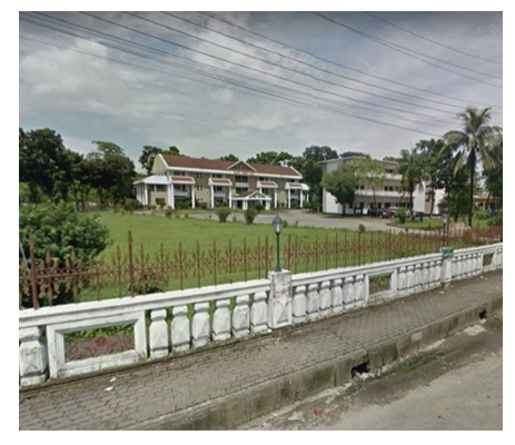
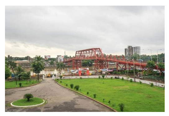
The location of the study area is situated at the centre of Sylhet city surrounding the remarkable Keane Bridge. It is a prominent area covering historical landmarks like ‘Ali Amjad’s Clock’, Circuit House, ‘Sarda Hall’, ‘Channighat er shiri’ and the bridge itself. But there exists a huge difference between the people living on each side of the river. Land use, urban morphology, public activity; all is totally different on each side. This makes a worse effect on the life of the people and the city itself. Most of the waterfront areas are occupied by government and private organizations. There is also a massive wholesale commercial land use that had developed illegally over time. 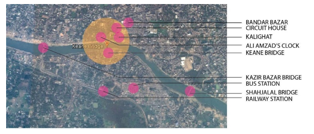 | Figure 2. Location and significant land use in the study area; Source: Google map (modified) |
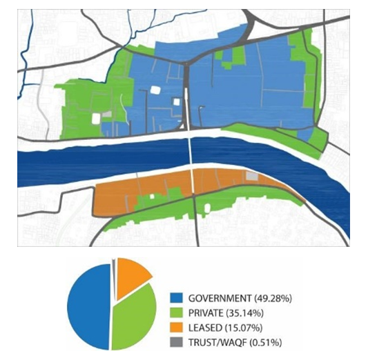 | Figure 3. Major land use zoning; Source: Author |
4.2. Waterfront Landscape
Naturally, the riverbank is bestowed with green grass and stone which makes a wonderful natural embankment (Figure 4). But concrete blocks have been used over it to protect the land from river erosion and wall has been made next to the blocks to prevent flood during heavy rainfall. Also, semi-permanent structures are built along the riverbank in the southern side and landscaping has been done which is now in abandoned condition as the surrounding functions are not supportive for making it work out (Figure 5). 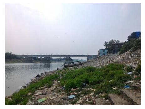 | Figure 4. Existing condition of waterfront; Source: Author |
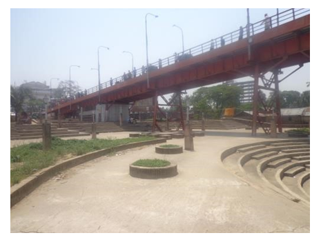 | Figure 5. Poor utilization of existing landscape design; Source: Author |
4.3. Accessibility
The study area is well connected by land and water transportation system with other part of the city. Road parallel to riverfront allowed both motorized and non-motorized vehicular option. Major transit location at court point is close to waterfront area. Often pedestrian is disconnected along the waterfront area because of illegal parking. There is only one street which runs towards the waterfront. Space for water transport called ‘Ghat’ is also available but frequently used for bathing, washing cloths and goods. 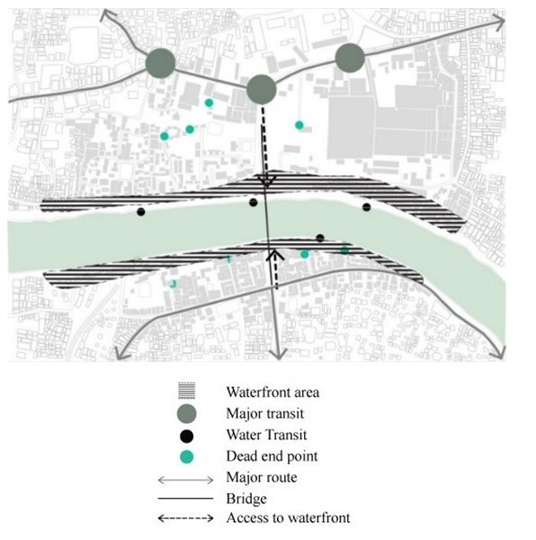 | Figure 6. Map of accessibility and transit; Source: Author |
4.4. Variety
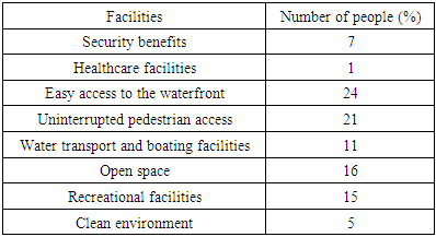
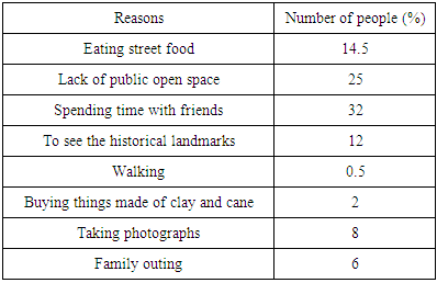
Variety of function invites different people, unlocks the diversity of different form and shares knowledge by mixing various people. The study area is occupied by large urban blocks particularly in the northern side which theatrically reduce the variety. According to the function, the area consists of wholesale market, governmental office and low-income residential area that significantly invites few people to satisfy their needs. At night these spaces remain less used due to lack of proper distribution of public recreational facilities. Table 1. Facilities that people need in the waterfront; Source: Author
 |
| |
|
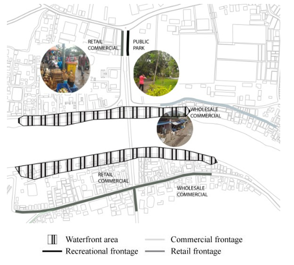 | Figure 7. Map of active frontage; Source: Author |
 | Figure 8. Example of inactive frontage; Source: Author |
4.5. Open Space and Activity
Waterfront should be a live and vibrant place with the presence of different ages of people full of different activities but here, the activities are the main concern. Currently open spaces are owned by public and private authority which remain inaccessible for city people. Moreover, public open spaces are located within the controlled area of different governmental office and most of the private open spaces are the front yard of the residence connected with the periphery road. Pedestrian is the only space from where people can enjoy the beauty of the waterfront. However, people used to visit waterfront area with their family and friends. Some public program is held in this area such as concert, fair, press conference etc. Table 2. Reasons why people go to the waterfront; Source: Author
 |
| |
|
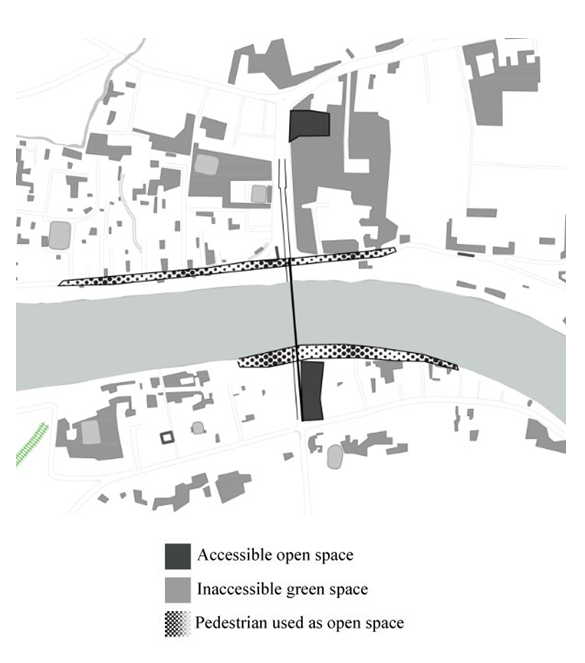 | Figure 9. Accessible and inaccessible open space; Source: Author |
 | Figure 10. Example of inaccessible open space (in front of circuit house); Source: Google |
5. Result
Poor accessibility: Lack of accessibility is one of the prime issues of waterfront degradation. Large urban blocks reduce the opportunity of accessibility in urban space. Also, the privatization of urban land use around the waterfront creates accessibility complications (Figure 3). There is only one access from both sides towards the waterfront which always remains crowded because of illegal vendor shops (Figure 6). Minimum pedestrian access is provided which is parallel to vehicular street and hazardous for walkers. Moreover, water transit system does not work properly in winter season because of low tide. So there is no alternative route to access the waterfront easily and safely.Lack of accessible open space: (Figure 9) shows some open space existing around the waterfront area which belongs to various government authorities like City Corporation, police, circuit house officials etc. These open spaces are inaccessible to the public and prohibited from any kind of public activity due to the safety measurement of government office (Figure 10). Often open spaces are surrounded by heightened wall which is an obstacle for visual permeability.Lack of variety of function: Public spaces demand variety of function to satisfy the needs of the user. Single function can invite only one group of people and reduce the dynamic nature of public character. In the study area, the land use is prominently divided by administrative and wholesale commercial function. There is no recreational and mixed-use development that can accelerate the presence of various user groups with different needs.Active frontage: In spite of having lack of various recreational facility, waterfront attracts city people (Table 2). Boat racing, immersion of idols, plant fair and some public events are held in this area. In the evening people go there to hang out with friends and eat street food like ‘Fuchka’. On the other hand, there is no active frontage in the southern part of the river which certainly forms a backside of existing buildings towards the waterfront area (Figure 7). Degradation of ecosystem and environment: In the past waterfront of Sylhet city was more natural and there was green bed along the waterfront slope (Figure 4). Due to flood threat, concrete block is used at river slope area that severely affects the ecosystem and the relation between soil and water has been damaged. Wholesale markets and small-scale industries produce huge solid wastes that are dumped into the river. Unplanned growth, deficiency of building design guideline and poor management system urges environmental degradation in the waterfront area.
6. Recommendations
Urban design framework has been developed to revive the waterfront of Sylhet city. The framework is described below and shown in (Figure 11).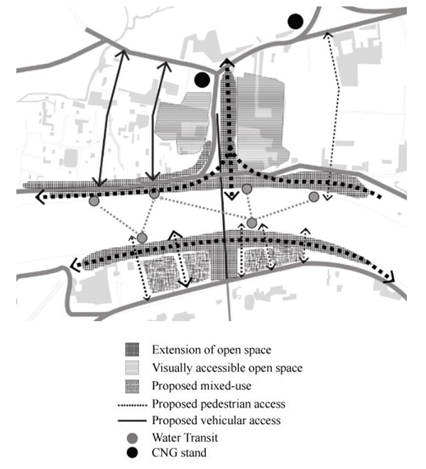 | Figure 11. Proposed design framework; Source: Author |
Ensuring public accessibility is a must needed step to make the waterfront area as a vibrant public space. The proper integration of different mode of transportation and pedestrian could represent a well network for public access. Physical and visual permeability helps to enhance the quality of public space. In this study, some vehicular and pedestrian route has been extended and connected to water transit (Ghat) to link between inner-city and waterfront.Exiting open space (Public Park) in court point is proposed to extend towards the waterfront which will create a green network connected with blue network (river) and can be a grand entrance for waterfront (Figure 12). The public open space in the waterfront will mark a natural buffer for other land use and reduce the risk of flooding. Inaccessible open space could be shared with the city people by public private partnership policy and open space programming. As a whole, the proposed open spaces will create openness rather than narrow vista and ensure circulation viability, ecological benefit and public recreation. 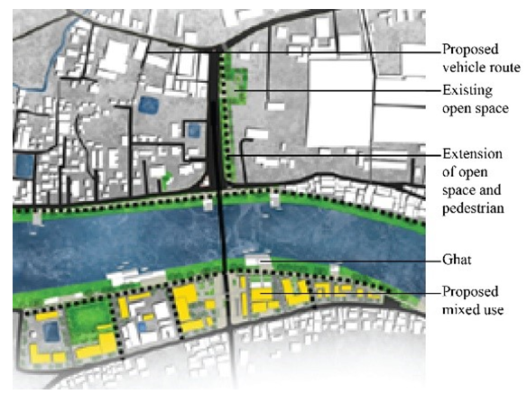 | Figure 12. Proposed master plan; Source: Author |
Activity needs function for enhancing the active frontage. Various public amenities and services are necessary to revive the lost space of the waterfront area (Table 1). Here, mixed use block has been proposed in south side of the waterfront which is supposed to increase the activity of frontage area and enrich the variety of urban space. Mixed use development as restaurants, craft shops, retail outlets, hotels, indoor and outdoor games along with residential facilities are necessary to satisfy local needs and invite tourist from other cities. A strong guideline is necessary from the city authority on the development control and use of urban waterfront. Special Building regulation should be introduced for waterfront area. And finally, the management authority like City Corporation should work with the stakeholders and local communities to develop plans and policies regarding the utilization of urban waterfront of Sylhet city.
7. Conclusions
Urban waterfront is a penetrable landscape of the city and creates a city edge where urban land meets natural landscape. Particularly in Sylhet, waterfront could be a potential public place to integrate northern and southern part of the city. A strategic target oriented planning and proper management would help to revive waterfront as the major public recreational space for city people and great attraction of tourist. Some urban design principle and technique should be followed to demonstrate the process. While cities of the world are trying to regenerate the unused waterfront, it is a responsibility of the government authorities and an opportunity for the stakeholders to protect the waterfront and make the best use of this special landscape.
ACKNOWLEDGEMENTS
We would like to thank all the people who helped make this investigation possible. Also, we would like to thank Shahjalal University of Science and Technology, Sylhet, Bangladesh for the technical support.
References
| [1] | Shaziman, S., Usman, I. M., & Tahir, M. (2010). Waterfront as public space case study; Klang River between Masjid Jamek and Central Market, Kuala Lumpur. In 6th WSEAS International Conference on Energy, Environment, Ecosystems and Sustainable Development, EEESD'10, 3rd WSEAS International Conference on Landscape Architecture, LA'10. |
| [2] | Hradilová, I. (2013). Influence of urban waterfront appearance on public space functions. Acta Universitatis Agriculturae et Silviculturae Mendelianae Brunensis, 60(8), 261-268. |
| [3] | Dong, L. (2004). Waterfront development: a case study of Dalian. Master of Applied Environmental Studies in Local Economic Development - Tourism Policy and Planning, University of Waterloo, 159 p., Canada. |
| [4] | Yassin, A. B., Eves, C. and McDonagh, J. (2010). An evolution of waterfront development in Malaysia. 16th Pacific Rim Real Estate Society Conference Wellington pp. 1-17. |
| [5] | Hou, D. (2009). Urban Waterfront Landscape Planning. Master thesis, Blekinge Institute of Technology Karlskrona, 53 p. Sweden. |
| [6] | Kristiánová, K. (2018). Promenade as landscape architecture strategy for riverbanks of small Danube cities: Komárno and Štúrovo. In Landscape Architecture-The Sense of Places, Models and Applications. Intech Open. |
| [7] | Plummer, B., & Shewan, D. (1992). City gardens: an open spaces survey in the city of London. Belhaven Press. |
| [8] | Hasan. M.T (2015) Rules, design and user behavior in public open space of Hong Kong, master thesis, The University of Hong Kong, Hong Kong. |
| [9] | Carmona, M., De Magalhaes, C., & Hammond, L. (2008). Public space: the management dimension. Routledge. |

 Abstract
 Reference
 Full-Text PDF
 Full-text HTML