Abdelmajeed Rjoub
Department of Architecture, Faculty of Engineering, Al-Albayt University, Al-Mafraq, Jordan
Correspondence to: Abdelmajeed Rjoub, Department of Architecture, Faculty of Engineering, Al-Albayt University, Al-Mafraq, Jordan.
| Email: |  |
Copyright © 2019 The Author(s). Published by Scientific & Academic Publishing.
This work is licensed under the Creative Commons Attribution International License (CC BY).
http://creativecommons.org/licenses/by/4.0/

Abstract
The study aims to focus on the informal housing types and locations in the city of Al-Mafraq of Jordan. The research followed the survey and analytical method, based on the study and analysis of maps and statistical data issued mainly by the Department of Lands and Survey and the Jordanian Department of Statistics and processing them with GIS software. The study revealed the existence of 5 types of informal housing that distributed over 8 residential districts in the city. The main reason for its existence was the absence of a comprehensive planning for land use that accommodates the new population as well as the inability of the authorities to control the growth of the city considering citizens' non-compliance with building codes and regulations. The study recommends the need for a new master plan for the city to control the trends of its expansion, the identification of land uses in non-organized areas and to intervene in the sorting of large areas and common property lands to cut the spread of informal housing.
Keywords:
Informal Housing, Outskirt Areas, Land Property, City Planning
Cite this paper: Abdelmajeed Rjoub, The Types and Locations of Informal Housing in Al-Mafraq City of Jordan, Architecture Research, Vol. 9 No. 3, 2019, pp. 51-62. doi: 10.5923/j.arch.20190903.01.
1. Introduction
According to the United Nations 2018 World Urbanization Prospects report, more people of the global live in urban areas than in rural areas and 66% of the world’s population will live in cities by 2050 and most urbanization will occur in Africa and Asia (United Nations, 2018). The population of the Arab world is on the verge of shifting from being predominantly rural to urban. As of 2010, more than half of the Arab world’s human population has resided in urban areas, and by 2050, urban inhabitants will account for approximately 75% of the Arab world’s population (Mirkin 2010). In this context, Jordan experienced a high rate of urbanization during the last five decades leading to concentration of population in the main cities (Makhamreh 2011).Since 2000 the housing market in Jordan has witnessed unexpected increase in demand with numbers of housing units. The main and major reasons for the housing and residential higher demand were; the high demographic and population growth of over than 80% on one hand, and on the other the migration of huge numbers of Iraqis, as result of the 2nd Gulf War in 2003, and now with wave of Syrian refugees migrating due to the Syrian crisis. Those reasons have driven prices of lands, houses, apartments, and all the suitable flats and dwellings to very high and expensive prices (Saho and Shukair 2017).On the national level, the Housing and Urban Development Corporation (HUDC) had formulated a National Housing Strategy (NHS) that has approved by government of Jordan earlier in 1989 (HUDC 2018). The NHS stated that there was a vast oversupply of vacant serviced residential land in the major Jordanian cities, but this land cannot be used for moderate or low-income housing and there is a corresponding shortage of vacant, serviced land which is appropriate for middle and moderate-income families, and no legal plots which are small enough to be affordable by low income families (Ministry of Planning 1987). The strategy lacks the idea of comprehensive and pre-planning long-term land use, which aims to enable the preservation of natural resources and agricultural lands and directing urbanization to avoid them, it also does not mention the mechanisms that dealing with the existing urban fabric in urban centres (Al-Nusair, 2004). The housing public sector plays a limited though important role in providing housing for specific population target groups. These include low income families in both urban and rural areas, Government employees and military personnel, and residents of the Jordan valley. The most recently a “Decent Home for A Decent Living” initiative was launched in early 2008 by a Royal Decree to provide affordable residential units, with competitive funding schemes, for all citizens (Al-oun et al 2010). The private sector has also become active in low-cost housing projects, with two of the most prominent being: Ahl Al-Azem project, which includes 15,000 apartments and 800 villas; and King Abdullah Bin Abdul Aziz City, which includes up to 70,000 affordable housing units (Khammash and Alkhas, 2009).The Jordanian government has been involved in efforts to provide low cost housing for the poor. The National Housing Strategy encompasses the various aspects related to housing such as the improvement of living conditions, support for the construction industry, the development of local building materials, community and so. Moreover, Jordan’s housing policy includes the provision of government loans at subsidized interest rates for construction. These credits are provided to both private individuals and to governmental agencies involved in public housing.Finding and securing decent housing remains a source of concern for many Jordanian families. Home ownership in Jordan is low by international standards, and real estate prices have risen dramatically over the past decade in many parts of country driven by a sharp rise in land prices and the pressure on housing supply created by successive waves of refugee migration to Jordan (Jordan Report 2025, 2019). The participation of the population themselves in securing their own housing based on their financial ability to purchase the land - if not available - and cover the costs of construction is the prevailing style in Jordan. The study of (UN HABITAT, 2019) confirmed that the price for a house on the market was well above the reach of lower middle-income Jordanians and the delivery of housing supply has not been well aligned with demand, leading to an oversupply at the middle and upper end of the market but a lack of affordable housing for the middle- and lower-income market. It was confirmed in this report that In Jordan, three events have shaped the current housing situation: 1) economic stagnation, 2) the rise in cost of living, and 3) the mass influx of refugees in the last three decades. For this and others reason, the population is forced to build their housing in unorganized (unplanned) and unserved areas either inside or outside the cities as a way for reducing the cost of acquiring housing. This has led to an increase of demand for what we called informal housing and disruption of the housing market in general.Recently Al-Mafraq faced many planning and administrative problems. The areas, types and locations of informal housing have increased significantly in and around the city, causing deterioration of the urban and social environment and have posed a threat to the security and health condition of the population. According to Sqour study (Sqour 2014) the city of Al-Mafraq as other Jordanian cities suffer a group of urban problems, some of these problems is losing balance between the built and unbuilt environment and reducing agricultural land, due to the random urban sprawl. Therefore, the research is interested in studying the problem of informal housing in the city.
2. Search Problem
The study concerned with the study of informal housing areas in Al-Mafraq that population of Al-Mafraq city tends to live in. These areas are in downtown areas and outskirts of city along the city's growth axes. They have been constructed during the stages of the development of Al-Mafraq and they have had negative impacts on the environmental and urban aspects as well as social and economic impacts on the population. They have poor environments in terms of quality of housing, construction materials, lack of basic services (water, electricity, streets, etc.).
3. Definition
Informal housing exists in urban contexts all over the world. Practices have resulted with creation of some sort of satellite cities, known in different languages as “spread city”, “generic city”, “divided city”, “irregular housing”, “informal settlement”, “un-authorized housing”, “informal development”, etc....Each of the wordings has its origin from the point of view that the author sees it, but it cannot escape the reality in which it is developed and taken shape, as well as the specific location where it is been established (Andoni, 2007). Various definitions have thus been proposed, but that suggested by the (UN HABIBTAT Program, 2015) is the most widely applicable. They define informal residential areas where:- Inhabitants have no security of tenure vis-à-vis the land or dwellings they inhabit, with modalities ranging from squatting to informal rental housing.- The districts usually lack, or are cut off from, basic services and city infrastructure.- The housing may not comply with current planning and building regulations, and is often situated in geographically and environmentally hazardous areasA range of academic studies from different disciplines has resulted in different emphases and influences and various labels including unauthorized, uncontrolled, unplanned, unorganized, informal or illegal urban housing have been applied to describe housing outside normal regulations. All these labels share one characteristic - the noncompliance with planning standards and regulations. Wu and Webster (2000) argue that in informal housing people often build what they want, where they want and at the density they want. (Alnsour and Meaton 2009) defined that the informal (unauthorized) house in Jordan is what constructed without compliance with planning regulations and residential standards. According to clause 2/11 of Jordanian Law of Planning of Cities, Villages, and Buildings, no. 79 for the year 1966, informal housing means any construction contrary to any certified or approved master plan, or to any law, instructions, order or notice, either it was implemented or under implementation, or any building affected by this violation under this law (1). The informal houses, which were built without construction allows in urban areas of Jordan, make up more than half of the urban building stock (Jaber and Probert, 2001). In most cases, informal house carried out without subsequent building acts and regulations. The result is a residential environment that does not meet the basic standards of housing and lacks the necessary services and infrastructure. (HUDC 2011).
4. Research Methodology
To achieve the research objectives, the researcher followed varied methods that combine quantitative and qualitative methodologies. The primary and secondary data sources were adopted as follows:
4.1. Primary Sources
Data and information available in records and publications Government departments relate to different geographical data such as maps, organizational charts of Al-Mafraq City issued by the Al-Mafraq Municipality and published and unpublished statistical sources.- The local, Arab, and international studies and researches that related to the subject of the study.- Field visits and urban analysis of the districts of Al-Mafraq at different time periods as the researcher is a resident of the city and he is aware of its development continuously.- Personal interviews with officials of the municipality of Al-Mafraq, and there were several interviews with the director of the Planning Directorate in the municipality in February 2019.- To identify the informal housing in Al-Mafraq City and its characteristics such as population and built-up areas, land ownership, type of building, the researcher was referenced to the GIS database issued by the Department of Statistics on the 2017 census and land plots in the Lands and Survey Department and the MGM.- Aerial photographs for the years 1953, 1978 and 2007, that were obtained by the researcher from the Jordanian Geographical Center and Google Earth images, to track the stages of the city's expansion.
5. About Al-Mafraq Governorate
Al-Mafraq governorate is located to the north-east of Jordan and covers 26552 km2 to be the second largest area in Jordan. It connects Jordan with Iraq in the east through Al-Karama Borders and with Syria in the north through Jaber Borders. It had a population of 58000 in 2017 and making up 5.8% of Jordan's population. (DOS 2017)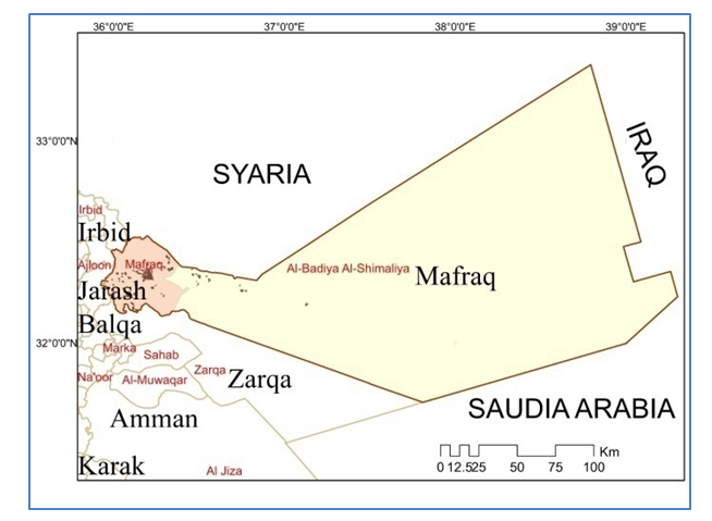 | Figure 1. Map of al-Mafraq Governorate showing the Al-Mafraq city and the populated areas. (Done by Author) |
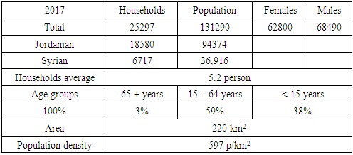
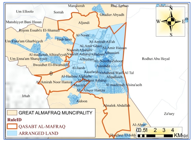
Population of Al-Mafraq governorate is heavily concentrated in the west, in and around the city of Al-Mafraq with a housing density of (22) p/km2. They distributed into (175) residential communities where just (17) of them are urban clusters (2). Excluding the Za'tri camp, Al-Mafraq is the only urban cluster with more than (100,000) inhabitants. The Za'tri camp is located 12 km east of Al-Mafraq and was established on 28 July 2012, as in March 2019 It is home to (77,447) refugees. (UNHCR 2019). Al-Mafraq city is the administrative center of Al-Mafraq governorate. It lies at west of governorate (32.34 latitude and 36.21 longitudes) and it is situated at elevation 705 meters above sea level. As of 2017 Al-Mafraq has a population of 131000 inhabitants (Female: 48%; Males: 52%). There were (23983) households, with an average of (5.2) persons per each. The society of the city is characterized by a youthful status, where about 38% of its population is under the age of 15 years, and about 59% are in the age group of 15-64 years, while only 3% are 65 years and above. The population density of the city reached 579 p/km2. (Table 1)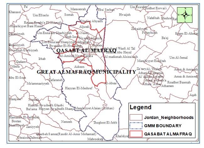 | Figure 2. The map of Al-Mafraq Great Municipality and Qasabat Al-Mafraq. (Done by Author) |
Table 1. Statistical Data of Al-Mafraq City. (Source: DOS, Census 2017)
 |
| |
|
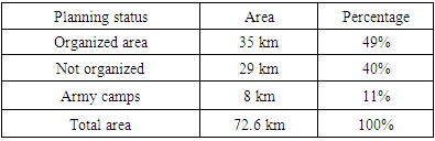
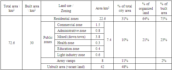
The Municipality of Al-Mafraq was established in 1944 (Al-Mafraq Greater Municipality, 2019) with an area of master plan about (4) km2. The city borders expanded along the Hijazi railway and the transport axes leading to neighboring cities Irbid, Jerash and Zarqa. After the Municipal Amalgamation Process in 2001, the city and the adjacent urban communities (villages) was officially known as "Al-Mafraq Great Municipality" (MGM), It consists of four major communities: Qasabat Al-Mafraq, Aidun, Um Al-Naa'm, and Thugret Al-jub (Jordanian Legislations, 2000). The total area of MGM is (220) km2 while the area of Qasabat Al-Mafraq is (72) km2. According to Jordanian statistical department, in 2017 MGM has a population of (131290) inhabitants, (111808) of whom are in Qasabat Al-Mafraq making it the principal urban cluster in the governorate.According to the last approved master plan the land of Al-Mafraq is divided into three main types: organized, unorganized and military land. The organized land is about 35 km2 (49% of total), the unorganized part is 29 km2 (40%) and the rest are 8 km2 (11%) are designated for military camps. (Table 2)Table 2. Distribution of Land by Planning Status in Al-Mafraq
 |
| |
|
The built-up area covers about 42% of city total area (about 80% of organized land). This part is divided into three main land uses: residential, public areas and army camps. Residential land plots occupy about 31% of total area (which consist about 75% of built-up area), public areas and the military camps cover about 21% of total area. (Table 3). The residential districts occupy the eastern and southern parts of the city and continue to grow towards the western and southern sides due to the existence of rural owned (private) land in that area (figure 3), While urban growth is restricted to the southern and eastern regions due to the existence of military camps and the Al-Albayt University (Sqour et al 2016).Table 3. Distribution of Land Use in the Built Area in Al-Mafraq City
 |
| |
|
 | Figure 3. The arranged land, street network and residential districts in Al-Mafraq |
6. Residential Land Use
The city consists of 20 residential districts with varying sizes and population densities. As shown in figure 4, Al-Nahda and Al-Hussein are the most densely populated districts with 20,000 inhabitants per square kilometer. Al-Qadisiyah and Al-Amer Ghazi are in second place with a density of 10,000 inhabitants per square kilometer. The rest of the districts are relatively low residential density and do not exceed the rate of 3000 people per square kilometer (Figure 4). According to the zoning regulations (Planning Law, 1966), there are 4 main classifications (classes) of residential land use (A, B, C, D). The dominant category of organized land for housing with the largest demand of population is (C) followed by category (D) because of their lot size and relatively cheap price (min. area 500 m2 for C and 250 m2 for D).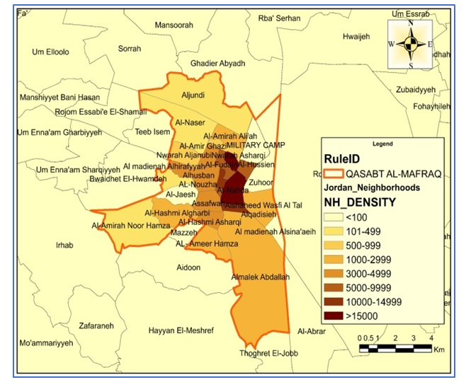 | Figure 4. The population density of districts in Al-Mafraq city (Qasabat). (Done by Author) |
As shown in figure 5, the small category (D) is concentrated in old districts (Downtown) (Al-Fudain, Al-Hussein and Al-Nahdah as well as in public housing projects), while category (C) is in the newly established districts in which the land has been arranged according to the city's expansionist plan since 2000. The land categories (A) and (B) are very few due to the lack of demand because of the relatively high price. (Figure 6).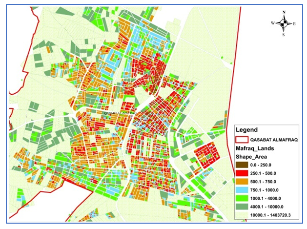 | Figure 5. Land distribution within organized areas in Al-Mafraq by plot area |
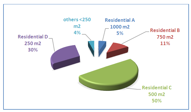 | Figure 6. Distribution of residential land use in Al-Mafraq according to their categories |
The housing type in Al-Mafraq is mostly characterized by uniform architectural style, dominated by a single family and one-story houses. Recently, multi-unit buildings have appeared in a very small proportion. Al-Husban districts is the most prestigious in terms of quality of housing.As for other unarranged lands (agricultural lands) within the organized boundaries of the city, which are mostly a common property land, where a weighty portion of it used for construction that contrary to the planning laws and building regulations to be as informal housing. (Figure 7)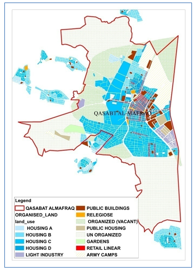 | Figure 7. The land use distribution in Al-Mafraq |
7. Informal Housing in Al-Mafraq
This part of research will examine and analyze the areas of informal housing in the city in terms of its historical development, reasons of their appearance, locations, types and their urban and architectural characteristics.
7.1. Historical Review of Informal Housing Formation
7.1.1. Period from (1920-1945)
Since the formation of the city in the 1920s, there has been a need for the population to serve in the army camps, the Hijazi railway, the TAP line, the Baghdad highway, and other projects that created jobs and attracted people to migrate from the neighboring cities and villages (Rjoub and Al-Husan, 2010). In the meantime, the city was a small village devoid of any prior planning and lacked basic services such as streets, water and electricity. Due to absence of municipal authorities at that time, informal residential districts were formed around the Hijazi railway station and along the railway line` (Rjoub and Al-Shawabkeh 2018). The first districts were Al-Husein (Asfora previously) and Al-Fudain. They were previously established on land with collective ownership and formerly divided among partners after construction. Therefore, they characterized by small plots areas (less than 500 m2), small housing units, irregular and narrow street network. Despite the numerous attempts to improve these districts, they still suffering from building violations, overcrowding, poor infrastructure and underprivileged urban environment. (Figure 8)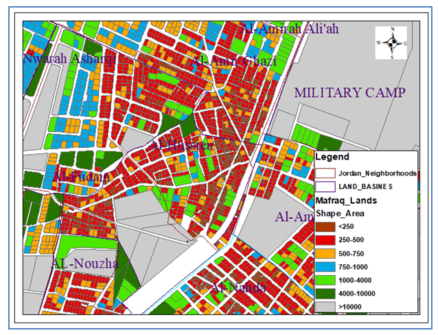 | Figure 8. Distribution of Al-Hussein district lands by plots area. (done by author) |
7.1.2. Period from (1945-1970)
During this period, the city underwent several changes and developments. Officially it was upgraded to become Al-Mafraq Municipality in 1945 and to be the administrative center of Al-Mafraq Governorate in 1985. The 1970s witnessed the development and the expansion of the city because of the economic boom experienced by the country, which was reflected in population growth and emergence of new districts. The military officers' district Al-Ameer Hasan (prev. Aldubbat (military officers)) and the southern district (Aljanobi) were established, as well as the commercial and administrative areas in the city center. Despite the typical planning of the street network in this district, the ownership of shared land, the quality of the population and the lack of timely intervention of the municipality led to the emergence of a residential environment devoid of the lowest standards of housing. (Figure 9)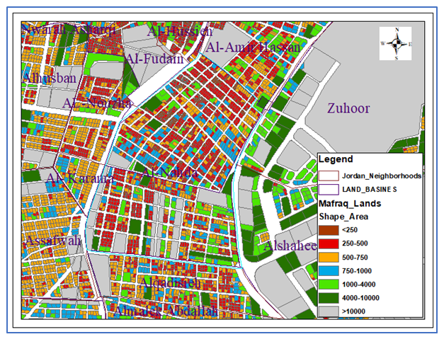 | Figure 9. Distribution of Al-Nahda districts lands by area (done by author) |
7.1.3. Period from (1970-2001)
At this time, the city witnessed a remarkable development in public services. The Al-Bayt University was established, and foreign students were accepted to study there, which had a major impact on changing the urban character of the city and increasing its population. The organized city's area has been expanded to accommodate new population, especially citizens returning from Kuwait after the Second Gulf War. In this period, districts were formed: Al-Janobi, Al-Nuzha, Al-Hashemi (prev. Shuweikah) and Nawara in the western and southern parts of the city. (Figure 10)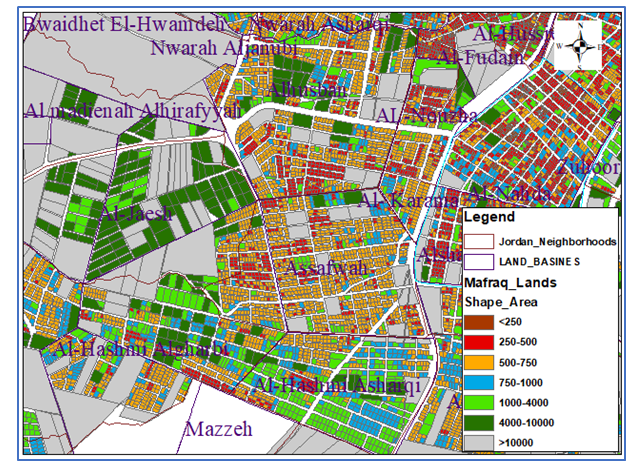 | Figure 10. Distribution of land plots by area of Al-Nuzha, Al-Hashemi and Nuwara districts (done by author) |
7.1.4. Period from 2001- now
In this period, the organizational area was expanded, and a new structural plan was adopted, adding the areas added after the policy of merging the Jordanian municipalities in 2001, and the city became known as “Al-mafarq Al-kubra” (Greater Al-Mafraq). A new phase has taken place after the Syrian crisis in 2011, which resulted in the influx of large numbers (estimated at 60,000 p) of Syrian refugees to the city. Pressure has increased on municipal authorities to provide health, education and housing services to newcomers. This unprecedented population increase was accompanied by a lack of housing stock. The private housing sector was directed to the empty, unorganized areas on the outskirts of the city due to its cheap prices and lack of control over the construction. Thus, the municipality's tasks increased, and the scope of its services expanded to include the new areas. However, the weak availability of the municipality did not coincide with this expansion, and a new construction wave began, resulting in unorganized districts and random residential areas. The districts of King Abdullah (Al-Mafraq Al-Janoubi) and Al-Ameera Nour Hamza were the most accommodating of the population during this period (Figures 11 and 12).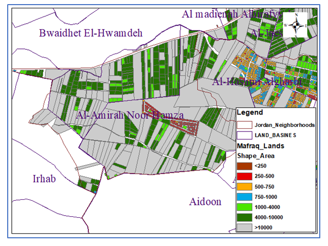 | Figure 11. Distribution of land areas in Al-Ameera Nour Hamza district |
 | Figure 12. Distribution of land areas in King Abdullah districts |
8. Types of Informal Housing in Al-Mafraq
According to the analysis above Al-Mafraq city has four types of informal housing that varying in their locations within the city, plot areas, planning status, building violations, quality of houses and common services. These areas were Al-Nahda, Al-Hussein, Al-Husban, Al-Malek Abdullah, Al-Ameerah Nour Hamza districts and public housing projects. (Figure 13)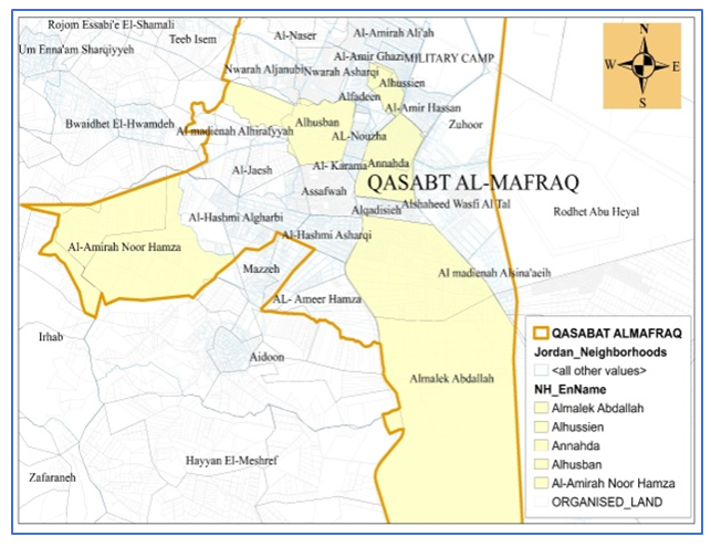 | Figure 13. Locations of informal housing districts in Al-Mafraq |
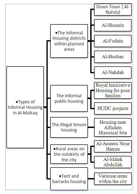 | Figure 14. Showing the types of informal housing and the districts and areas that represent each type |
8.1. Informal Housing within the Organized Areas
The districts that were formed since the early period of the city (now the city down town) and conformed to building laws, but the social and economic changes have led to a transformation of houses and their urban pattern. This is reflected in building violations, enlarged residential density, narrow streets and unstructured confusion in land use (residential, commercial and administrative). Districts of Al-Nahda, Al-Fudain, Al Hussein, Al-Husban are represent this type. Despite the authority’s intervention to improve the urban environment of these areas by dividing the land properties, providing the required infrastructure and services (electricity, water, sanitation, etc.), they are still obvious violations of poor construction materials, construction on sidewalks, roads, and poor built environment in general. So, they required more attention to consider the population needs and aspirations for the best. (Figure 15)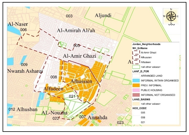 | Figure 15. The current planning status of housing districts in Al-Mafraq down town |
Al-Maqam land basin within Al-Husban district is one of the distinctive cases of informal housing where random planning and construction appear despite its planning status (within the organized area) and its closeness to the city center. The area of the district is 903347 m2 and it consists of two large area plots, the first plot area is 827617 and the second is 75730 m2. The first plot property is shared by 287 people (as in March 2018). The collective property areas range from 130 m2 to 250000 m2. People started construction their houses in this district since 2014, after the municipality allowed in violation of the law - due to the multiplicity of properties and not to divide the land according to the division law - by providing them with the so-called (occupancy license) for obtaining water and electricity services. The owners, with the help of brokers, divide the area that they own into small plots of 500 m2, so they can easy sell it at relatively cheap prices (comparing with the price of organized land). This is encouraged by the absence of state procedures and less control over construction and planning in general. (Figures 16 and 17)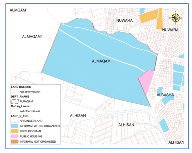 | Figure 16. The current planning status of Al-Maqam basin (Al-Husban district) |
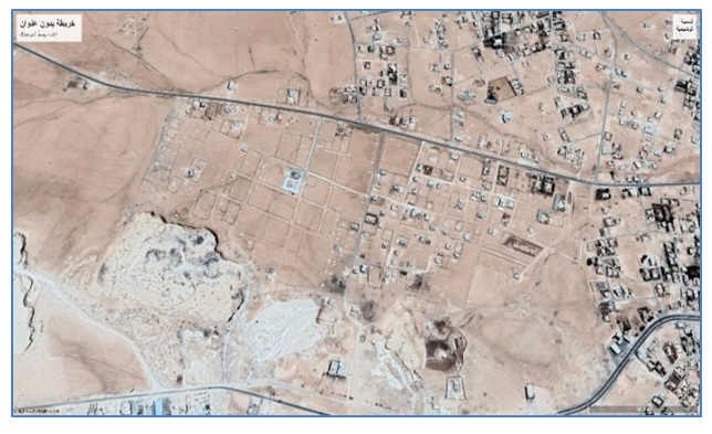 | Figure 17. The aerial view of Al-Maqam basin (Al-Husban district) (Source: Google Earth) |
8.2. Informal Public Housing
These are the houses that constructed by Housing and Urban Development Corporation (HUDC) for state employee, low- and middle-income groups. Despite the decent conditions of the houses at the time of its construction, they have been deteriorated due to lack of interest and continuous maintenance, as well as due to the modifications made by residents to accommodate their new needs. Violations that observed in these districts are random horizontal and vertical expansion, the use of bad building materials and encroachment on streets and sidewalks. The areas that represent this type of informal housing are Housing and Urban Development Project (1st and 2nd phases) and The Royal Housing Initiative for Poor Families. (18)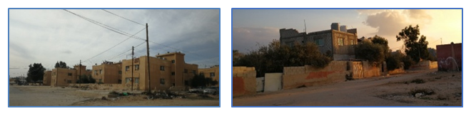 | Figure 18. Showing the status of public housing buildings and environment (HUDC project) in Al-Mafraq |
8.3. Rural Areas on the Outskirts of the City
It is the most common type of informal housing in the city, which is spawned by urban expansion, population growth and the need for new residential districts. These new districts are sprawled along empty farmland on the outskirts of the city. These lands are dominated by large areas and collective ownerships, mostly of so-called "tribal interfaces" of the Bani Hassan tribes. Because of the large areas of land plots and multiple partners, and because the law of the division of land prevents the division of agricultural land to less than 4000 square meters per one plot, it is difficult for each partner to determine his share of the land just after the agreement between all partners or waiting until the change the status of land use to be as residential. The land is then can divided into small plots according to the residential category specified in the master plan of the area. Except that, this may cause a dispute that prevents partners from exploiting the land for a long time. In other cases, the partners may begin to plan the land among themselves, where they can determine their share of the building. In case of non-construction and to reserve his share, the partner builds either a low-rise fence or a simple structure (one room) pending the state involvement to founding of legal ownership. This type of housing is the most prevalent in the city of Al-Mafraq, but it has a negative impact on the subsequent planning processes because of the vast areas of land that lead to abuse, in addition to the lack of infrastructure and basic services being outside the organized areas. The districts that represent this type of informal housing are Al-Malek Abdullah and Al-Ameera Nour Hamze districts. (Figures 19, 20 and 21)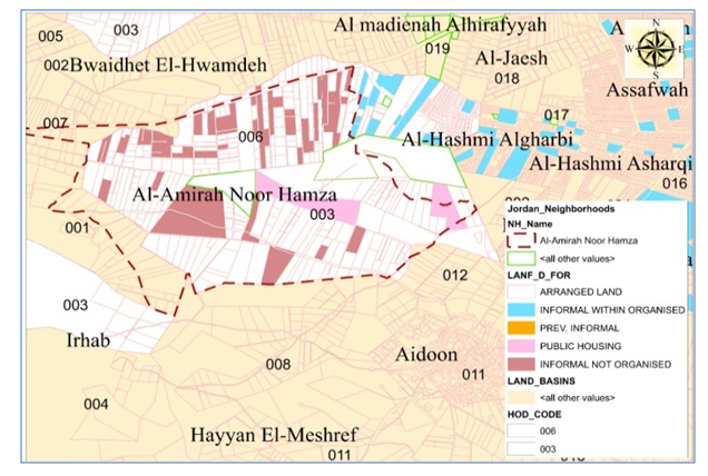 | Figure 19. The planning status of Al-Ameera Nour Hamze district |
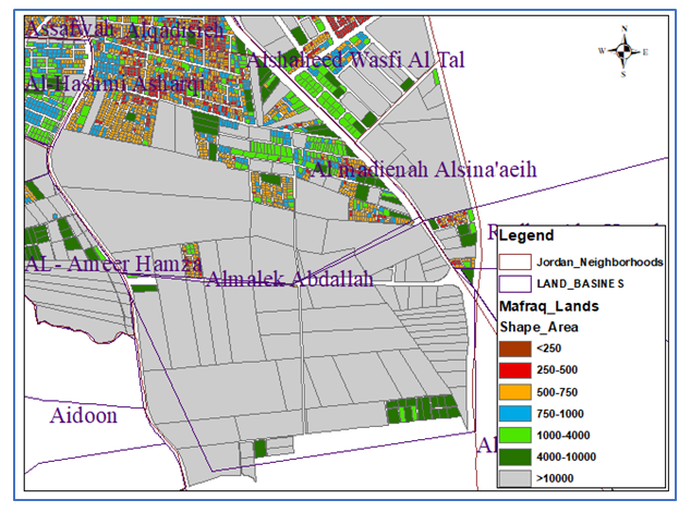
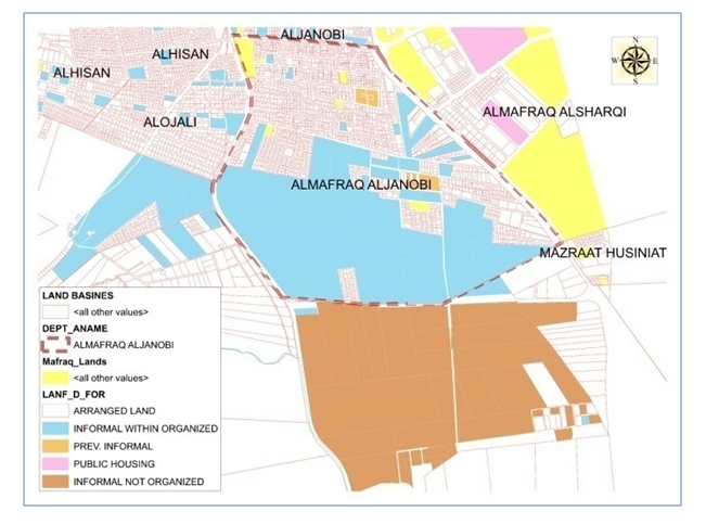 | Figure 20. The planning status of Al-Malek Abdullah district |
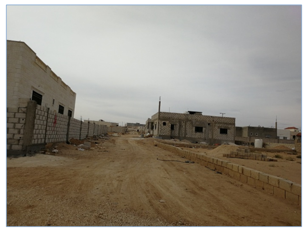 | Figure 21. Showing the status of housing buildings and environment of Al-Malek Abdullah district in Al-Mafraq |
8.4. Illegal Tenure Housing
These houses built by citizens on not their own lands, but on public property (treasury land), usually in areas close to heritage sites, reserves, camps and empty land. As some citizens build their houses at intervals of time informally and randomly, forming a deteriorating urban environment with high housing density, high rate of room occupancy and increase the pressure on the infrastructure and basic services in the region. Examples of this type in Al-Mafraq are the houses that built on Alfudain archaeological site. The number of these units is about 30 houses. These houses suffer from poor construction and are characterized by their randomness and common land ownership. Despite the illegal construction of these buildings, the state remains unable to solve the problem because of the weakness of control and the reluctance of them. (Figure 22)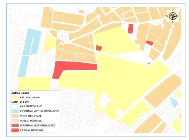 | Figure 22. The current planning status of Alfudain housing districts |
8.5. Tents Housing and Camps
The housing type that began to spread a lot after the influx of Syrian refugees who preferred to live outside the camps assigned to them in search of jobs and adequate housing, as well as to live in groups with ties of kin and descent. They set up their own camps in isolated areas on the outskirts of the city, despite the lack of services and infrastructure in such areas. Despite the poor living conditions of this type of housing, they were encouraged to be able to adapt and create a relatively favorable housing environment, as well as the supporting of foreign institutions played a big role in securing part of their requirements. Examples of this informal housing type are the camps located in Block 22 of Al-Hosban basin in Al-Mafraq.
9. Conclusions
The study shows that there are four informal housing types in Al-Mafraq, which are spread in eight main districts of the city. The characteristics of these districts vary in terms of the quality of housing and the residential environment as well as the characteristics of randomness and the factors affecting their rise. These districts are: Al-Nahda, Al-Hussein, Al-Fudain, Al-Husban, Al-Ameera Nour Hamza, Al-malek Abdullah, the public housing projects for employees and the housing for poor families. The characteristics of these districts summarized as follows:- The largest of these districts in terms of area is King Abdullah district that amounted to 1299592 m2.- The largest in terms of population is the down town district (Al-Nahda) that amounted to 26859 people.- The largest in terms of population density is Al-Hussein district that amounted to 24279 people / km2.- The largest of these districts in terms of number of housing units is the Al-Nahda district that contains 5630 housing units.- Two of these districts are located on the outskirts of the city in the unorganized areas: Princess Noor Hamza and King Abdullah districts, while all other districts are located within the organized areas.The most important reasons in making people to live in Informal housing are administrative, urban planning, economic and social motives. The informal housing is a joint decision among different actors including state and partners of land ownership.The urban planning issues are summarized in the absence of a master city plan that defines land use for organized areas, shortage of arranged land, Illegal irregularities in construction and planning, noncompliance with planning standards and regulations and lack of control by the authorities of new urban growth.Most informal districts suffer from a lack of public services and infrastructure (water, electricity, waste disposal and sanitary networks, streets, public services, green areas and playgrounds), resulting in poor sanitary conditions and environmental pollution in these areas.The following (Table 4) includes a summary of general characteristics of informal housing districts in Al-Mafraq in terms of types, locations, population, area, housing density, number of housing units, the planning status and the percentage of built-up areas in each district.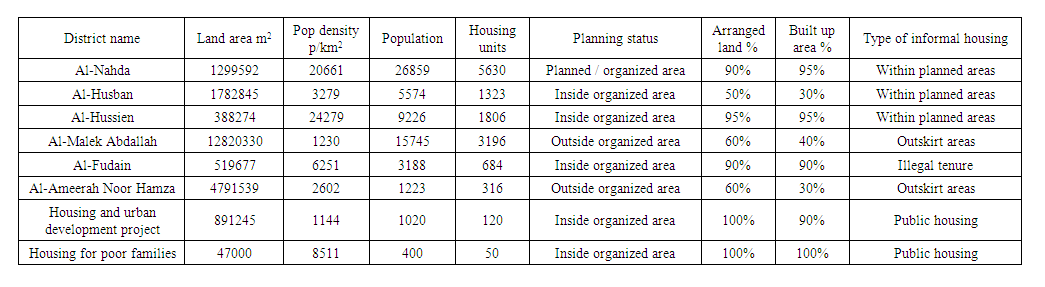 | Table 4. General characteristics of informal housing districts in Al-Mafraq |
10. Recommendations
- It is necessary to continuously develop areas and residential districts and study the prediction of trends in demand for housing and encourage investment in the residential sector.- To pay attention to the development of rural areas and the development of their services, which will contribute to their recovery and their ability to confront urbanization and the consequent changes in urban uses.- The need for laws to protect agricultural land adjacent to the city and the implementation of comprehensive schemes for land use to reduce the spread of informal housing.- To accelerate the development of existing informal residential areas, solve their planning and organizational problems, divide land ownership, provide basic services and meet the needs of the population.- Reviewing the laws and legislations governing the real estate and housing sector so that to consider the ability of citizens of the middle and poor classes to insure their needs of housing with reasonable specifications.
ACKNOWLEDGMENTS
This research was carried out by Dr. Abdelmajeed Rjoub while on sabbatical leave from Al Albayt University for academic year (2017-2018).
Notes
1. The main authority responsible for the various planning acts sanctioned in Jordan cities (except Amman) is the Ministry for Municipal Affairs (MOMA), while the Physical planning mainly is carried out according to several laws and legislation: The Law of Planning of Cities, Villages, and Buildings, no. 79 for the year 1966, Jordan National Building Law no. 7/93, and Municipality law no 29 for 1955 Law of Planning Cities.2. Based on the 2017 census, each population group with a population 5000 inhabitants and more was considered an urban cluster.
References
| [1] | Alnsour and Meaton, Factors Affecting Compliance with Residential Standards in the City of Old Salt, Jordan. Habitat International, 33 (4). pp. 301-339. |
| [2] | AL-Nusair A, The Housing Conference: Housing Policies between reality and future aspirations. Department of housing and urban development. Amman, 2004. |
| [3] | Al-own S. Fitness between House Choices versus Market Production in Jordan, Urban Dynamics & Housing Change - Crossing into the 2nd Decade of the 3rd Millennium, January 2010 Conference: ENHR Istanbul, Turkey. |
| [4] | Andoni D 2007. The Paradigm of Legalization - a Paradox or the Logic of Development. Conference: The need for modern Estate Cadastre and Spatial Planning, Sounio, Greece, 28/31/March. |
| [5] | Department of Statistics. Census of 2017. |
| [6] | Housing and Urban Development Corporation, Informal Housing in Jordan. Directorate of Policies, Management of housing policies, Amman 2011. http://www.hudc.gov.jo (in Arabic) 26/6/2019. |
| [7] | Housing and Urban Development Corporation (HUDC), Strategic Plan and Executive Program (2019-2016) http://www.hudc.gov.jo (in Arabic) 26/6/2019. |
| [8] | Jaber J, and Probert S.D, Energy demand, poverty and the urban environment in Jordan. Applied Energy 68(2):119-134, 2001. |
| [9] | Jordan 2025 Report. A National Vision and strategy. Part 1 p 31. Online copy at site: http://inform.gov.jo/Portals/0/Report%20PDFs/0.%20General/jo2025part1.pdf 25/6/2019. |
| [10] | Jordanian Legislations, Jordanian Municipalities law # 70, 2001 p1. |
| [11] | Khammash T. and Alkhas Z. Real Estate Sector Report. ABC Investments, Research Department: Amman, Jordan, June 2009, pp 1-45. |
| [12] | Makhamreh Z. Analyzing the State and Pattern of Urban Growth and City Planning in Amman Using Satellite Images and GIS European Journal of Social Sciences – Volume 24, Number 2 (2011). |
| [13] | Ministry of Local Administration http://www.mma.gov.jo/DPage.aspx?ID=21 20/5/2019. |
| [14] | Ministry of Planning. National Housing Strategy. Draft Final Report (Executive Summary) Technical Memorandum Number 22. Prepared by The Shelter Unit Witr Assistance by PADCO Inc. The Urban Institute USL International. 1987. |
| [15] | Mirkin, B. Arab Human Development Reports paper series: series 1. Population levels, trends and policies in the Arab Region: Challenges and Opportunities. UNDP regional Bureau for Arab States. 2010 |
| [16] | Rjoub A, Al-Husan R, Islamic Ottoman Architecture in Jordan, Alfdain / Al-Mafraq Forte in on Darb Al-Haj Al-Shami as example. Jordan journal of History and Archeology. Volume 4 Number 4 2010. |
| [17] | Rjoub A, Al-Shawabkeh R., Urban and Architectural Impacts of Hejaz Railway in Mafraq-Jordan. International Journal of Humanities and Social Science, Volume 8 Number 1 January 2018. |
| [18] | Saho A., Shukair S. Management and Finance of Jordanian Housing Market (2000-2016), Global Journal of Management and Business. Volume 17 Issue 6, Version 1, 2017. |
| [19] | Sqour et al, Development and Trends of Urban Growth in Mafraq City, Jordan. Architecture Research 2016, 6(5). |
| [20] | Sqour S. Urban Planning and Design in Times of Rapid-moving Events in Jordan. Journal of Modern Science and Technology Vol: 2. No: 2. 2014. Pp.59-68. |
| [21] | The Jordanian Law of Planning of Cities, Villages, and Buildings, no. 79 for the year 1966, clause 23/5. |
| [22] | UN HABITAT. Habitat for Humanity Europe Middle East and Africa. Country profile, Jordan. 2019 https://www.habitat.org/sites/default/files/documents/Jordan_2019.pdf. |
| [23] | UN HABITAT. Habitat III Issue Papers 22 – Informal Settlements New York, 31 May 2015. https://unhabitat.org/habitat-iii-issue-papers-22-informal-settlements/. |
| [24] | UNHCR. Zaatari Fact Sheet March 2019. https://data2.unhcr.org/en/documents/details/69095 26 April 2019. |
| [25] | United Nations. World Urbanization Prospects Report, UN 2018. https://www.un.org/development/desa/publications/2018-revision-of-world-urbanization-prospects.html. |
| [26] | Yasin B, Rjoub A. Standardization in Construction as a Tool to Reduce Cost of Housing for the Low-Income Families in Jordan. Journal of Civil Engineering and Architecture 11 (2017) 141-148. |

 Abstract
 Reference
 Full-Text PDF
 Full-text HTML