-
Paper Information
- Paper Submission
-
Journal Information
- About This Journal
- Editorial Board
- Current Issue
- Archive
- Author Guidelines
- Contact Us
Architecture Research
p-ISSN: 2168-507X e-ISSN: 2168-5088
2018; 8(3): 92-102
doi:10.5923/j.arch.20180803.02

Is Urban Morphology a Panacea or a Peril to Sustainability?
 Abstract
 Reference
 Full-Text PDF
 Full-text HTML
Maurice Onyango Oyugi
School of the Built Environment, Department of Architecture and Building Science, University of Nairobi, Nairobi, Kenya
Correspondence to: Maurice Onyango Oyugi, School of the Built Environment, Department of Architecture and Building Science, University of Nairobi, Nairobi, Kenya.
| Email: |  |
Copyright © 2018 The Author(s). Published by Scientific & Academic Publishing.
This work is licensed under the Creative Commons Attribution International License (CC BY).
http://creativecommons.org/licenses/by/4.0/

In the recent decades, realisation that global warming and climate change is caused and exacerbated by increased urbanisation and greenhouse gas (GHG) emissions has heightened studies on the links between urban morphological parameters of development density, land use, vegetation index and the urban sustainability parameters of urban heat islands, air quality, climate change and global warming. The urban morphological attributes notably the development densities, building materials and configuration, street orientation and width, man-made structures and green belts attenuates wind flow within the street canyons and the urban canopy layer which in turn affects the distribution of the urban thermal values as well as the dispersal and concentration of air pollutants. The above further explains the occurrences of higher surface temperatures in the cities relative to their hinterlands. Scholars therefore agree that there is a significant relationship existing between urban morphology and sustainability parameters of surface temperatures and air quality. This paper therefore explores the potentials and pitfalls of urban morphology in the achievements of urban sustainability.
Keywords: Urban Sustainability, Urban Morphology, Urban Heat Island, Air quality, Land Use, Development Density and Vegetation Index
Cite this paper: Maurice Onyango Oyugi, Is Urban Morphology a Panacea or a Peril to Sustainability?, Architecture Research, Vol. 8 No. 3, 2018, pp. 92-102. doi: 10.5923/j.arch.20180803.02.
Article Outline
1. Introduction
- Despite cities being engines of national development, they are continuously under threat occasioned by pollution, congestion and environmental hazards arising from high urbanisation rates. According to Van der Ryn and Cowan (2007), unsustainable urban design practices not grounded in ecological principles has made urbanisation come at the expense of natural ecosystems to distance man away from nature and today, cities are characterised by sprawl, traffic snarl, wastes and hazardous emissions which defies pollution prevention and control efforts. Urban morphology emanating from planning decisions has implications on urban sustainability. For example, high development densities enable Planners to achieve economies of scale in infrastructure provision, but also impose high costs associated with congestion, thermal discomforts and air quality degradation. On the other hand, low development densities in a city means reduced congestion, but urban sprawl, loss of agricultural land and higher costs of infrastructure provision. Therefore to bridge this gap and to link man with nature, there is need for ecological consideration in the planning and management of cities.The concept of urban morphology was first expressed in the writings of the Poet and Philosopher Johann Wolfgang von Goethe in 1790. Since then, the term has extensively been used in Geography, Urban Planning, Architecture and other related disciplines. These scholars have defined the concept depending on the focus of their studies. For example, Gilliland and Gauthier (2006) defines urban morphology as the study of a city’s physical form, which consist of development density, land use, street patterns, building configuration and population density while Moudon (1997) defines urban morphology as the study of a city as a human habitat. Despite diverse definitions of urban morphology by various scholars, an area of convergence is that an analysis of a city’s morphology should begin with dissection of how the city has evolved over time and space, identification of the urban elements and subsequent transformations which have taken place on the elements as well as how the physical form produces various social forms.Urban morphology has since evolved to discern the physical approach into a body of knowledge analysing the urban fabric as a means of understanding the urban structure (Moudon, 1994). This approach challenges the perception of urban centres as chaotic organic (unplanned) environments. According to Moudon (1997), Urban Morphologists focus on socio-economic forces moulding cities through constant transformation of elements notably the buildings, gardens, streets, parks and monuments. This portrays cities as unconscious products that emerge over a long period of time through accrual of successive generations of developments which leaves traces that restructures the urban elements by either providing opportunities or constraints to successive developments. This has led many to prefer the term Urban Morphogenesis to describe the field of study and the logic of these traces.Three schools of thought exist in the study of urban morphology namely; the Italian, British and the French. The Italian school of thought dates from 1940s and is centred on the works of Saverio Muratori who attempted to develop an operational history for the cities he studied. This was meant to provide rationale for the integration of new architectural works in the syntax of the urban tissue (Emmanuel, 2005). Muratori’s views were further advanced by Gianfranco Caniggia who conceptualised a city as a dynamic procedural typology of buildings, gardens, streets, parks and monuments shaped by political and economic forces. The British school of thought is centred on the works of M.R.G Conzen, who developed a technique called town-plan analysis (Moudon, 1997). For Conzen, understanding the urban building fabric and land use through history is imperative in comprehending the urban morphology. This approach has been applied by his followers such as J.W.R Whitehand and Peter Hall in the management of historic and contemporary townscapes. The realisation that the relationship existing between the built spaces and the social world is dialectical made the French school of thought based at the Versailles School of Architecture to place emphasis on the importance of built spaces in sustaining social practices. In America, urban morphology as a field of study owes its origins to Lewis Mumford, James Vance and Sam Bass Warner (Moudon, 1994).
2. The Relationship Existing between Urban Morphology and Sustainability
- The relationship existing between urban morphology and sustainability is anchored on Urban Boundary Layer Dynamics Theory which explains how urbanization determines the Urban Energy Balance, Surface Temperature Variations, Heat Islands Effects, Air Pollutants’ Concentration and Dispersal, Global Warming and Climate Change. Further to building configuration attenuating wind velocity to subsequently influence the distribution and concentration of air pollutants, the waterproofing and thermal properties of the materials used in the constructions influence the concentration of anthropogenic heat and the distribution of surface temperatures. However, this relationship is moderated by the geographic setting (relief, elevation and regional climate), size of a city, population density and proximity to water body (Mills, 2007).The Urban Boundary Layer Dynamics Theory posits that the urban atmosphere consists of two sub-layers namely the urban roughness and canopy sub-layers. The climatic conditions in the urban roughness sub-layer are defined by heat and moisture exchanges between the city’s overlying air and the urban surface elements such as the roofs, trees, lawns and roads among others (Schmid, 1994). On the other hand, the climatic conditions of the urban canopy sub-layer which is the lower part of the urban atmosphere, extending from the ground to the average height of urban buildings is influenced by energy fluxes from the urban elements. Since heat fluxes, mass and momentum change with height, the roughness and the canopy sub-layers are not in equilibrium (Grimmond and Oke, 1999a).
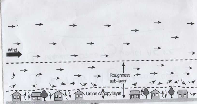 | Figure 1. The Urban Boundary Layer Dynamics (Source: Grimmond and Oke (1999a)) |
 | (1) |
 | (2) |
3. Effects of Urban Morphology on Sustainability
- Urban sustainability is of concern in densely populated cities where urban infrastructure, morphology, topography and climate interact to produce uncomfortable thermal and hazardous air quality effects. This is because cities influence GHG production and sinks both directly and indirectly (Sánchez et al. 2005). For instance, carbon dioxide which is a major component of the GHGs is a by-product of urban anthropogenic activities such as industrial and transportation activities. Clearance of land for urban expansion and infrastructure development are drivers of regional land cover changes which reduces the global carbon sinks.Changes associated with urban developments have profound effects on urban surface temperatures and air quality which consequently have effect of inducing climate change. New surface materials associated with urban buildings, roads and other urban infrastructure alters the natural surface which consequently alters energy balance, water exchanges and airflow. The above combined with heat, carbon dioxide and other GHGs emitted by anthropogenic activities result in distinct urban climates. One of the best-known effects of such development is urban warming of which globally cities are warmer than the surrounding rural areas but with internal urban spatio-temporal variations (Oke, 1997). On average, urban temperatures may be 1°C to 3°C warmer than rural environs, but in calm and cloudless nights, air temperatures can be more than 10°C warmer than surrounding rural environments (Grimmond et al. 1993).At the urban scale, the spatio-temporal variations in urban temperatures is accentuated by the neighbourhoods’ attributes such as the amount of vegetation on site, density of development and the nature of the construction materials used in the neighbourhood. This manifests in form of pockets of sites within the urban landscape with higher temperatures than the rest of the urban spaces, a phenomenon called the urban heat island. The urban heat island effects are exacerbated by the anthropogenic activities such as vehicular traffic, industrial production and domestic buildings which produce heat, sulphur dioxide, nitrous oxide, suspended particulate matter and carbon dioxide, GHGs known to contribute to global warming and climate change (Voogt and Oke, 2003). These gases interact with the city's compact mass to affect energy exchange and levels of thermal conductivity. However, factors such as topography in relation to the sun’s angle and aspect are as influential as the surface type in controlling the amount of radiation received and absorbed. Thus a low-vegetated area incidence to direct solar radiation is much warmer as compared to vegetated areas (Fung et al. 2003).Land uses and the distribution of development densities within an urban area define its form. This influences the transportation mode used in the city as well as the city’s energy consumption and GHG emissions. Urban morphology, particularly development densities, building configuration and land uses has implications on a city’s GHG emissions. This is because proximity of homes and concentration of services coupled with provision of efficient public transportation accentuated by compact (high density) urban development encourages walking, cycling and the use of mass transport instead of private motor vehicles. This consequently leads to decline in fossil fuel consumption per capita (Newman and Kenworthy, 1989). However, this is complicated by the fact that urban centres are industrial hubs and GHG emissions coming from industries outstrip those from the transportation sector. Compact developments induce usage of less energy for heating. For example, households in the United States of America living in single-family detached housing consume 35% more energy for heating and 21% more energy for cooling as compared to households living in other forms of housing due to urban heat island effect (Quattrochi et al. 2000).The urban land uses equally influences the GHG emissions. This is demonstrated by energy usage differentials in four urban spatial structures notably mono-centric, poly-centric, composite (multiple-nuclei) and urban village models. In the mono-centric cities, most economic activities and amenities are concentrated in the Central Business District (CBD). In this situation, the authorities focus on promoting public transport as the most convenient mode of transport, for most commuters travel from the suburbs to the CBD while in the poly-centric cities, few jobs and amenities are located in the centre and most trips are from suburb to suburb. In this regard, a large number of possible travel routes exists, but with few passengers per route. Therefore public transportation is difficult and expensive to operate and private means of transportation becomes convenient option for users. The composite (multiple-nuclei) model is the most common type of urban spatial structure. This model manifests a dominant centre with a large number of jobs located in the suburb’s minor centres. Under the composite model, most trips from the suburbs to the CBD are made using public transport, while trips from suburb to suburb are made using private means of transportation. This necessitates the need for both public and private modes of transportation. The urban village model is utopian and is a creation of the urban master plans. In this model, urban areas contain many business centres, commuters travel only to the centre which is the closest to their residence and have more opportunities to walk or cycle to work. This model is ideal for it requires less transportation due to the reduced distances travelled to work. This lowers the energy usage and the GHGs emission. The more the urban spatial structure encourages public transportation, the more it leads to less emission of GHGs and other air pollutants and vice versa.High rates of urbanisation have exacerbated increased development densities in the cities. This is beneficial for the conservation of open spaces and natural resources, enhancement of social relationships as well as enabling urban authorities to deliver more housing stock and employment stations within walking distances. However, high development densities exacerbate overcrowding, noise and air pollution (The Jerusalem Institute for Israel Studies, 2005). Lowry (1977), notes that as urban centres grow towards mega cities, their natural vegetation get replaced by skyscrapers which provide multiple surfaces for the reflection and absorption of terrestrial energy. This increases the efficiency with which urban areas are heated to raise the urban air temperatures. Moreover, concrete materials used in urban constructions have thermal retention capacity which limits rapid cooling after evening transition. The buildings attenuate wind velocity and cause turbulences which restrict the air pollutants to narrow canyons within the neighbourhoods. This allows the pollutants to settle and increase in concentration (Vougt, 2002). Therefore, development density and building configuration is today known to adversely affect the urban sustainability.Development density is the best tool for shaping urban sustainability, yet agreements on whether to adopt low or high urban development density is often emotive. Based on the lessons learnt from the European and North American cities, it is imperative to find a middle ground between the two models. High density development is viewed as anti-suburbanisation and an indicative of claustrophobic squalor, poverty and deprivation. On the other hand, low-density urbanism is equated with selfish gated communities and the environmentally disastrous car-orientated suburbs. However, it grants individuals freedom to spacious living and can be presented as a model of freedom and sturdy individual choice (Dodman, 2009). Views on the impacts of urban development densities have tended to be polarising as noted by the works of Howard (1898) and Jacobs (1996). Howard (1898) argues that it is universally agreed by men of all parties that it is deeply deploring that people are still streaming in already overcrowded cities. On the other hand, Jacobs (1996) whose work, The Death and Life of Great American Cities is taken as a mantra for new urbanism movement (those opposed to the suburban sprawl and restrictive residential enclaves) is passionate in the defence of high development densities. According to Burton (2000), a study of medium-sized English cities suggests that while high urban development densities lead to reduced living spaces, it has the ability to improve public transportation, reduce social segregation and enhance access to utilities and amenities.Low development densities are viewed as the main causes of urban sprawl. However, the definition and the effects of urban sprawl on urban sustainability are widely debated. Frenkel and Ashkenazi (2008) states five parameters for detecting urban sprawl as growth rates, development density, spatial geometry, accessibility and aesthetics. Urban sprawl is often associated with problems such as social isolation, obesity and asthma, global warming, climate change, the demise of farmlands and extinction of wildlife. However, some scholars argue that urban sprawl is inevitable for it is an outcome of free-market mechanism (Gottdiener and Budd, 2005). In low and middle-income countries, peri-urbanization is increasingly taking place and the boundaries between urban and rural areas are continually being re-negotiated. The interfaces between the two are often afflicted by slums, inadequate urban services and degradation of farmlands. This is because planning regulations are inadequately enforced in the peri-urban neighbourhoods for such neighbourhoods are outside the legal and administrative boundaries of the cities (McGregor et al. 2006).Cities constituting 2% of the earth surface are responsible for 75% of global energy consumption, 80% of GHG and 90% of anthropogenic carbon emissions. Therefore, cities significantly contribute to global warming and climate change (Angel et al. 2005; Satterthwaite, 2008; Jusuf et al. 2007; Svirejeva et al. 2004). A study of GHG emission in Toronto City concludes that low density suburban developments consumes between 2.0 to 2.5 times more energy annually than densely developed neighbourhoods. This is because high development density encourages low car ownership and requires less energy for heating, cooling and to power the buildings (VandeWeghe and Kennedy, 2007; Dubeux and La Rovere, 2007; Norman et al. 2006). A study of 16 variables in 45 Chinese cities concludes that there is a positive relationship existing between urban development density and sustainability up to a certain level as other variables such as income levels, urban spatial structure, transportation network, surface temperatures and population size explains why cities in Southern Asia are densely settled than cities in North America yet they generate high levels of GHGs (Chen et al. 2008; Mindali et al. 2004). In as much as high urban development density encourages compact urban form which reduces GHG emissions, high development densities cause localised climatic effects such as increased surface temperatures, urban heat-island effects as well as increased outdoor and indoor air pollution (Coutts et al. 2007). As noted by Neumann (2005), compact urban form is not singly sufficient for the improvement of urban sustainability. Therefore, other strategies such as enactment of policies related to public transportation, building regulations and reduction of household energy consumptions must be entrenched in the urban development agenda if sustainability has to be realised (Campbell-Lendrum and Corvalán, 2007). Jabareen (2006) identifies seven pillars of urban sustainability as urban form, public transportation, development density, mixed land uses, diversity, passive solar design and greening. He used the concepts to compose a sustainable urban form matrix and concludes that compact city model is the most sustainable, followed by the eco-city, neo-traditional development and urban containment. Indeed doubling a neighbourhood’s density combined with green buildings and smart-growth technologies decreases automobile usage by 30%, with a corresponding decline in gasoline consumption and GHG emissions (Walker and King, 2008; Brown and Southworth, 2008).Sea-level rise exacerbated by increased GHG emissions, global warming, climate change and increased precipitation provides the linkage between urban development density and sustainability. Climate change induced by GHG emissions and global warming is likely to increase the intensity of natural hazards such as storms, cyclones, tsunamis, flooding and erosion in the coastal cities (Satterthwaite et al. 2007; Pelling, 2003). According to IPCC (2007), a rise in global average temperatures by 2°C or more will exacerbate coastal flooding while a temperature rise of more than 3°C may result in loss of about 30% of global coastal wetlands and agricultural land as occasioned by water logging and salt stress. Other likely effects of temperature rise are inadequate freshwater supplies, destruction of property, loss of human lives and increased prevalence of environmental, malnutrition and cardio-respiratory diseases. Further to temperature variations associated with global warming and climate change inducing frequent and intense heat waves, it also results in additional cost of environmental control within buildings as well as increased concentration of air pollutants (Kovats and Akhtar, 2008; Awuor et al. 2008; Dodman and Satterthwaite, 2008). It has been established that the urban heat island intensity rises with increasing urban population (Mihalakakou et al. 2004; Hinkel et al. 2003). Towards this end, Oke (1973) developed a regression model for the North American and European cities which successfully explained 97% of the variability in urban heat island intensity and concludes that urban population is the single most significant variable influencing the intensity. The model further posits that for every increment of 100,000 people within a city, there is a corresponding 1°C temperature increase. Alterations of urban land uses and land cover indirectly modify the urban climate (Chandler, 1976). For example, in America, surface temperature increases have been observed where extensive forests and other natural vegetations have been cleared (Skinner and Majorowicz, 1999). Kalnay and Cai (2003) estimates that over the past fifty years in the United States of America, land-cover changes have resulted in 0.27°C mean annual surface warming. Narisma and Pitman (2003) having observed the impacts of land cover change on temperatures in Australia, supported the postulations of Kalnay and Cai (2003). Other studies such as Sailor and Fan (2002) and Unger et al. (2001) concludes that for large urban areas, depletion of vegetation cover increases surface temperatures by between 1.67°C to 2.22°C during summer and by 5.6°C during winter.Vegetation mitigates the heating and polluting effects generated by the urban developments through a combination of shading and evaporative cooling effects. This is because vegetation through photosynthesis sequences carbon dioxide gas in the atmosphere thereby mitigating the greenhouse effects (Kubota and Ossen, 2008; Weng et al. 2004; Brovkin, 2002; Grimmond et al. 1996; Spronken-Smith and Oke, 1998). Vegetation facilitates cooling of the urban temperatures through evapo-transpiration which involves the conversion of solar radiation into latent heat of vaporisation. The latent heat of vaporisation then escapes with the sensible heat to the atmosphere (Fujibe, 2003; Giridharan et al. 2004; Chudnovsky et al. 2004). Therefore, vegetation density differentials within urban neighbourhoods explain the surface temperature variations among the same. Vegetation also impacts on urban storm water management. For example in Baltimore, it was determined that neighbourhoods with 40% tree cover reduce surface runoff by 60% more than neighbourhoods without trees. Further, vegetation has effect on wind velocity and precipitation regime of urban areas which in turn affects the urban sustainability (Mahmood et al. 2010). It is evident that as anthropogenic activities continues to alter the natural ecology of cities through urban development processes; the long-term energy exchanges taking place within the boundary layer are affected. This is because the surface properties influence the atmospheric energy budget and by altering the surface conditions, man has inadvertently affected the atmospheric properties which influences local, regional and global climate through the cascading linkages of the atmospheric, terrestrial and hydrological systems (Dixon and Mote, 2003; Rozoff et al. 2003). Therefore, global warming and climate change may not be attributed to the effects of the GHGs alone but also to the effects of heat islands occasioned by urbanization (Arnfield, 2003).
4. Conceptual Model and the Proposed Methodological Approach to Verify the Relationship Existing between Urban Morphology and Sustainability
- The correlation between urban morphology and sustainability takes cognisance of the effects of urban morphological elements such as land use, development density, building configuration and land cover on sustainability indicators such as the urban air quality and surface temperatures. Development densities influence household’s mode of transportation and energy consumption, all of which have implications on a city's GHG emissions. Similarly, industrial land uses generates GHGs. Replacement of urban vegetation with impervious materials such as concretes, asphalt and steel reduces evapo-transpiration with net effect being increased surface temperatures and urban heat island effects which cause thermal discomfort and increased energy demand in the buildings (Przekurat et al. 2011).Poor air quality occasioned by increased number of automobiles and industries in the urban centres is a significant environmental problem facing cities. This is because automobiles and industries generate GHGs, suspended particulate matter and sulphur dioxide. This is further complicated by the urban skyscrapers which attenuate wind velocity to restrict air pollutants to narrow canyons, subsequently raising the concentrations of the same. This is best mitigated by the vegetation which acts as sinks to air pollutants (Mölders, 2012). Vegetation also provides shade, creates aesthetic appeal and sense of community. Therefore, a development which diminishes the vegetation cover lowers the ability of the environment to reduce air pollution and to cool.Interactions between forces underpinning urban developments such as the infrastructure, land markets, planning regulations and people’s inclinations to environmental conservation present a web of constraints to the achievement of sustainable cities. As illustrated by Figure 2, achievement of urban sustainability requires implementation of multiple strategies entailing innovative urban design, promotion of green infrastructure, tightening legislations protecting urban ecosystems (the green belts, trees and river restoration), re-orientation of urban institutions, provision of adequate urban transportation and infrastructure, enhancement of socio-economic developments, community, public and private sectors participation, civil society involvement as well as institutional capacity building for planning both at the urban and regional levels.
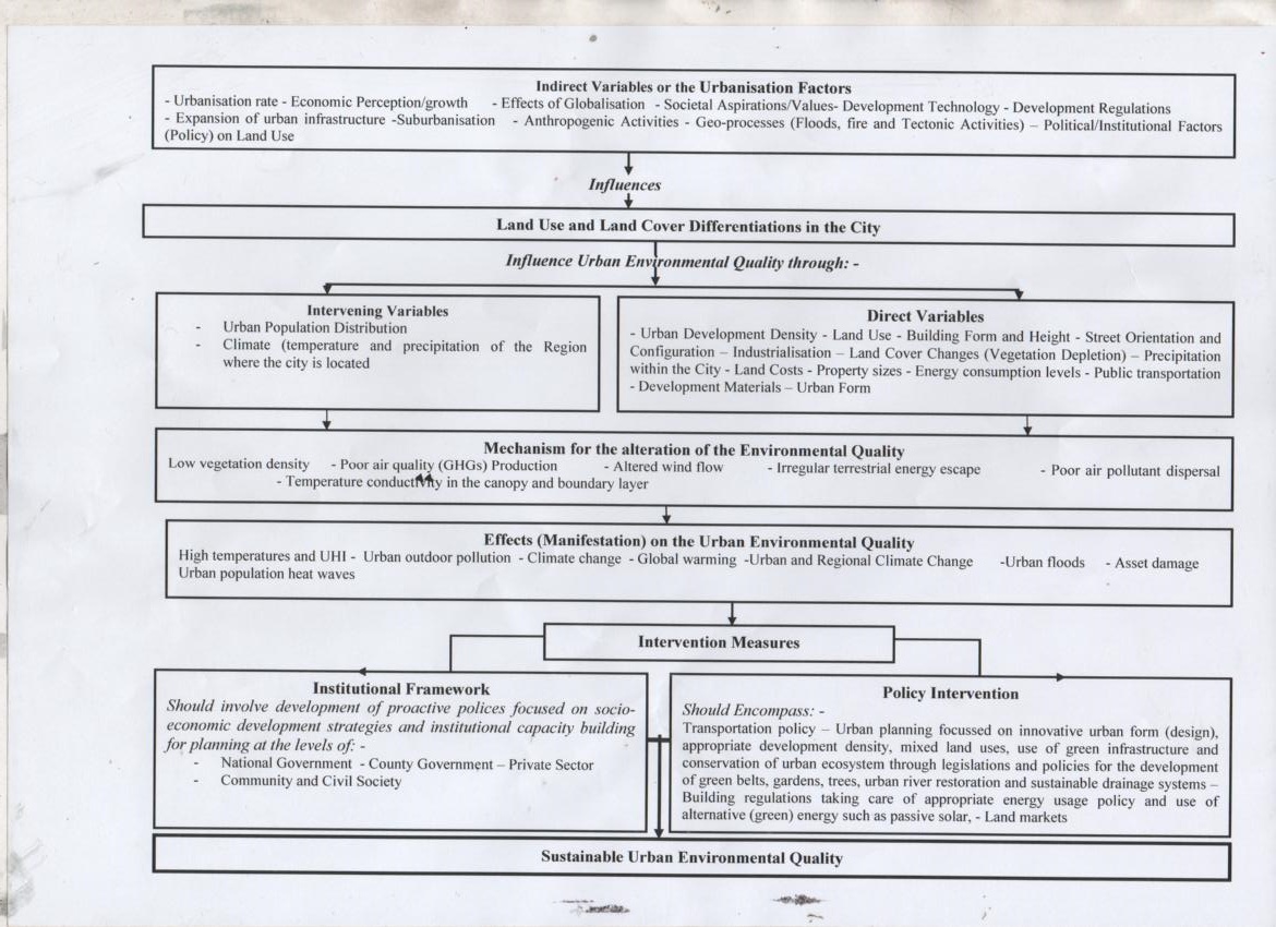 | Figure 2. Conceptual Model for the Realisation of Urban Sustainability |
 | (3) |
|
 | (4) |
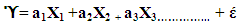
 = The dependent variablesXs= The independent variablesas = Coefficient of determinations of the independent variablesέ = The error term
5. Conclusions
- The achievement of urban sustainability requires implementation of multiple strategies and techniques which are known to work within the standard urban planning and management practice. As earlier mentioned, such strategies should include promotion of green infrastructure, innovative urban design, tightening up legislations protecting urban ecosystems as well as implementation of sustainable drainage and transportation networks. Urban sustainability agenda further requires a new urban development contract encompassing civil society, public and private sector participations. Other measures should include re-orientation of legal, institutional and development infrastructure towards delivering urban sustainability. This should build on the strengths of planning and other urban management strategies which give more scope and encouragement to local action, behavioural change and innovation. Therefore, urban sustainability should be anchored on proactive policies focussed on socio-economic development and institutional capacity building for planning both at the community, citywide and regional levels.