-
Paper Information
- Paper Submission
-
Journal Information
- About This Journal
- Editorial Board
- Current Issue
- Archive
- Author Guidelines
- Contact Us
Architecture Research
p-ISSN: 2168-507X e-ISSN: 2168-5088
2017; 7(4): 123-145
doi:10.5923/j.arch.20170704.02

Urban Form and Sense of Community: Exploring Catalysts for Community Sustainability within Al-Wakrah Neighborhood in Qatar
 Abstract
 Reference
 Full-Text PDF
 Full-text HTML
Maryam Alfaraidy, Raffaello Furlan
College of Engineering, Department of Architecture and Urban Planning, Qatar University, State of Qatar
Correspondence to: Raffaello Furlan, College of Engineering, Department of Architecture and Urban Planning, Qatar University, State of Qatar.
| Email: |  |
Copyright © 2017 Scientific & Academic Publishing. All Rights Reserved.
This work is licensed under the Creative Commons Attribution International License (CC BY).
http://creativecommons.org/licenses/by/4.0/

Urban planners seek to create a sense of community by effectively interfacing urban form and community development. In Qatar, community change has become a matter of public concern amid intense development activities. The recent exposure to modernization-related urban growth in Qatar, in preparation for temporary mega events and in pursuit of the national vision, has increased Qatari society’s acquaintance with hypermodern lifestyles and diverse community interactions within urban amenities and forms. A declining sense of community amongst tension between recovery and adaptation on several spatial and progressive scales of modern growth is commonly associated with social problems that delay development and diminish a community’s well-being. Integration of community with the urban context strengthens the community while improving urban outcomes in newly developing areas. In New urbanism, this occurs by translating social and physical concepts of community and resilience into operational measures and outcomes allowing consideration of the demographic and social factors that connect with the broader context of developments and settlements, relating findings to urban development, community resilience, and the body of sustainability-related literature to aid future research. Concepts of community sustainability are examined qualitatively in the context of urban forms within the Al-Wakrah neighborhood. Site visits, photography, observation of selected nodes, and interviews with community members investigate urban characteristics as catalysts for sustainable community development. These findings can inform physical and social community planning decisions without jeopardizing the vital arteries of the past or the formation of a structure for city and community.
Keywords: Sense of community, Urban form, Al-Wakrah, Resilience
Cite this paper: Maryam Alfaraidy, Raffaello Furlan, Urban Form and Sense of Community: Exploring Catalysts for Community Sustainability within Al-Wakrah Neighborhood in Qatar, Architecture Research, Vol. 7 No. 4, 2017, pp. 123-145. doi: 10.5923/j.arch.20170704.02.
Article Outline
1. Introduction
- Qatar, like many Gulf countries, began applying principles of Euclidian zoning, as seen in the Western developed world, during the 1970s (Furlan, Almohannadi et al. 2015; Furlan 2016; Furlan and Almohannadi 2016; Furlan and Faggion 2017). In turn, this has raised considerations of stakeholders’ versus developers’ perceptions of a place, as well as the level of awareness afforded its original occupants and of to what extent the master planning stage reflects an understanding of urban environment’s social and physical connective tissue (Camagni, Gibelli et al. 2002). Proliferating urban forms have given short shrift to sustainable development, disconnecting certain traditional features—e.g., social hotspots, diversity, compactness, community ties—that were once features of the city, thus distancing developers from the community’s physical and social needs (Camagni, Gibelli et al. 2002; Furlan, Almohannadi et al. 2015). In Qatar, locals sought ownership of large villas and land ever farther from the city center, leaving old settlements to lower-income nonlocals(Giorgi 1998; Mazelan 2002) (Furlan, Eissa et al. 2015; Furlan and El-Ekhteyar 2016; Furlan and Shurbaji 2017). This phenomenon weakened ties with both community and place, for example, old Msheireb in Doha underwent extensive gentrification and heritage-focused development that sought to reintroduce and preserve historical memories of Doha city amid growing modernization (cf. the Msheireb exhibition) (Salama 2007; Salama and Wiedman 2013; Furlan and Faggion 2015; Furlan, Nafi et al. 2015; Remali, Salama et al. 2016). As such changes eroded cities’ grounding in heritage, local authorities cast about for alternative measures of sustaining a city’s history that could still coexist with modernity. During the 1970s, European philosophers and planners sought resolutions for the community problems accompanying such developments. This research study identifies the urban concepts most associated with community attachment in Qatar, in hopes of modeling resilience in urban development.The Case Study of Al-WakrahAl-Wakrah began as a fishing and pearling settlement but grew into a highly-populated area featuring compelling expressions of urban form and history (Jaidah and Bourennane 2010; Jodidio and Halbe 2015). In recent decades, Al-Wakrah has preserved a strong sense of community and heritage. Accordingly, it offers rich ground for examining the interrelation of community and urban forms. Major urban nodes exert an intangible influence and Al-Wakrah’s invisible web connecting physical context and community experience is key to its unique sense of community (Fromherz 2012).This research study examines “community as a place, community as relationships, and community as collective political power” (Chavis and Wandersman 1990) in Al-Wakrah around these nodes, gathering public input and conducting site, demographic, social, physical, and environmental analysis so as to accurately reflect the community’s life patterns and values (Furlan and Faggion 2015; Furlan 2016; Zaina, Zaina et al. 2016; Furlan and Faggion 2017; Furlan and Sipe 2017).These categories are themselves undergoing as-yet-undetermined social change amid excessive development, both general and transit-oriented, in Al-Wakrah (Petruccioli and Pirani 2003; Petruccioli 2007; Furlan and Petruccioli 2016). This research study proposes a process for increasing community and urban resilience throughout, rooted in the community’s physical environment, for “the community development process focuses on the development of human ecologies by empowering the community with the development of physical amenities as economic and environmental resources while in return, sense of community acts as a mechanism to stimulate the healthy development of the environment and the people who inhabit it” (Chavis and Wandersman 1990).
2. Review of the Literature
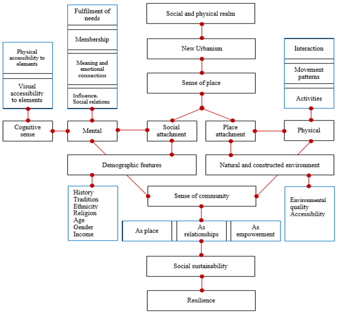
- Sense of Community and Urban FormTraditional urbanism or neighborhood development and New Urbanism primarily consider the relationship of the community’s social and psychological aspects in the context of the community and the neighborhood as a whole (Farr 2008; Altoon and Auld 2011; Roorda 2012). Not surprisingly, then, “the social doctrine of New Urbanism is integrated with the social community formation science literature” (Talen 1999). A sense of community is foundational in the social and physical realm, being an essential contributor to membership, commitment, and mattering in a neighborhood context. Yet this is not a static approach: as community members share history, public places, and experiences, values evolve and so do other external influencers, such as commerce, transportation, specialization of professions, and economics (McMillan and Chavis 1986; Beske 2007). Thus, a sense of community is defined by community members’ sense of place. Indeed, “programming for local communities and value of public place that has more priority to these communities must support the feeling of local life.” Sense of place as a concept of community comprises physical setting as well as activities linked to this setting and the subject’s conception of this setting (Farkisch, Che-Ani et al. 2011; Stevenson 2013). A sense of community, for its part, comprises two main aspects: a sense of social belonging and a sense of place belonging. Christian Norberg-Schulz, theorized about sense of place in the 1960s, during Europe’s period of intense industrialization, modernization, and recovery. He ascribed the condition of ‘‘crisis’’ in architecture to the failure of modern architecture to take account of some of the essential factors that give significance to the built environment, primary among those the role of perception, in addition to the importance of history as a source. He attempted to create a system that would reason for the various poles of architectural activity. The framework for this study included a combination of scientific ideas derived from sociology, psychology and semiotics. He emphasized the importance of design that reinforces uniqueness of place, sensitive to the genius loci by approaching planning from the user perspective as a journey through spaces, giving primary consideration to mental comprehension and scale transformation in static and high-mobility areas. Following his approach, Gorden Cullen, who saw the city as a field of visual experience comprehensible only through visual logic, with communication occurring by induction (juxtaposition of imagery) and inner action (causation of experience) “approaches his planning by 3 elements, optics — this concerned the experience of walking through the town at a uniform speed in which the scenery of towns was revealed in a series of jerks and revelations, called serial vision, place — a person’s reaction to the position of the body in an environment of exposure and enclosure, content — concerned with the fabric of towns; color, texture, scale, style, character and uniqueness”. This could be attained by planning neighborhoods and communities that stimulate a sense of community through social interfaces that can be enhanced through physical urban fabrics such as walkability, visual and physical accessibility, presence of public hotspots, and social interaction—increasing individuals’ sense of community, identity, and belonging (Haenfler, Johnson et al. 2012) (Bramley, Dempsey et al. 2009).Integrating these definitions into planning directly enhances the well-being of occupants through social sustainability. Community formation thus requires social interaction, a sense of safety, availability and accessibility of services, and provision of high-quality interactive public environments. Ease of access to different areas, amenities, and services is influenced by physical and social accessibility (Bramley, Dempsey et al. 2009). Individuals may face indirect segregation when various stigma make certain zones comfortable and or uncomfortable for different community groups. Sustainability of community includes “Inter relations between pride in and attachment to neighborhood; social interaction within the neighborhood; safety/security (vs risk of crime, antisocial behavior); perceived quality of local environment; satisfaction with the home; stability (vs residential turnover); participation in collective group/civic activities” (Bramley, Dempsey et al. 2009).This cycle of interrelated disciplines networked through physical systems both constructed and natural, as well as through human communities in which heritage and development are equals, produces a resilient community (Forgaci and Van Timmeren 2014) where capability of individuals, communities, institutions, businesses, and systems within a city to survive, adapt, and grow no matter what kinds of extreme changes occur.Demographic profile in relation to sense of communityCommunities layer history, tradition, heritage, and demographic categories as they relate to urban surroundings based on norms, knowledge, tradition and history. Examination of key demographic characteristics in the existing population is thus central to any consideration of urban community dynamics (Rossiter 2011). Similarity of ethnicity and religion enhances interactive behavior and well-being (Bramley, Dempsey et al. 2009), but minority groups compromise to a degree that reflects their values and needs (McMillan and Chavis 1986). Social networks of activity help regulate behavior in the city through normative solutions, exerting informal social control influenced by community demographics. Families that have a history in and ties to a place have a stronger sense of belonging and empowerment, reflected in the aesthetic organization of space and the city’s general image, both social and physical (Chavis and Wandersman 1990).
 | Diagram 1. Concept sequence Source: Author |
 Sense of place (place attachment, social attachment)
  Sense of community In examining each aspect of form, the authors primarily focus on the effects of urban forms on community but also highlight certain aspects of demographic and social influencers.Sociopolitical and socioeconomicA resilient community depends on physical urban fabric and structures that enhance socioeconomic activities while increasing community wealth and use of modern technologies. “The key to resilient communities is to locate available local assets, connect them with one another in ways that multiply their power and effectiveness” (Adams 2013).Policymakers influence planning decisions and urban patterns of property distribution, land use, and development, with politics a function of community empowerment and community economics. In Qatar, the Majlis is an external extension of the residence, allowing male members of the community to interact frequently, with activities and sense of authority determined by social level. Interactions concerning economic, political, and social issues bring empowerment through hierarchal participation in development or planning decisions, much like modern-day practices of public participation.Urban identity and city featuresProximity to major cities, urban transformation, and general region all influence community growth and change. The sustainability of the local area depends on how the street matures environmentally, socially, culturally, and economically.As forms affect community members’ perceptions of a city, multiple dynamics of cognitive and physical interactions create experiences, memory, and meaning in the space (Farkisch, Che-Ani et al. 2011). Traditional urban spaces’ transition hierarchically from macro to micro depends on the local community, attention from pedestrians and other mobile entities, social identification, and community identity (Farkisch, Che-Ani et al. 2011).Open public spaceThese areas allow community members to create relationships and integrate. Traditionally, a hierarchy of activity runs from the central part of the city through main streets, small streets leading to neighborhood centers, alleys, and houses’ entry halls and courtyards (Farkisch, Che-Ani et al. 2011). City centers, where retail and social entertainment activities take place, see continuous motion (Hakim 1999). The most important traditional public spaces, Alhara and Albaraha, saw social and economic activities, with mashrabiya and courtyards offering privacy and climate control (Hakim 1999). These features are now embodied in commercial streets with high levels of pedestrian activity and public squares. The influence of Islamic values on social life and urban forms is undeniable, with specific buildings, such as mosques, serving as major social nodes (Hakim 1999). The Barahah__a common space concept of residential units, intended to encourage interactions in a positive environment, thus enhancing a sense of community and the resilience of the entire complex. Use of traditional city water features in urban spaces has become common. Studies by the Water Master company in Qatar have associated positive behavior with proximity to large water features, which boost well-being and enhance climate control (Pradhan 2012). According to Fatima Hassans, an engineer for the Msheireb district development project, New Msheireb saw a 2°C decline by placing public fountains in built-up pedestrian areas. Green spaces promote social gatherings and pedestrian interactions while boosting environmental sustainability and a sense of well-being. The combination of water features with planted space is more effective still (Pradhan 2012).Walkability and aesthetics as symbols“Through providing a pedestrian-friendly environment for increasing residents’ face-to-face opportunities and casual social interactions between neighbors, developers and planners in the U.S. have adopted New Urbanist (NU) development strategies seeking to return to the design of the early transitional neighborhoods to enhance the sense of community (SOC)”(Tsai 2014) considering the relation, Sikka, the old streets of Arabian cities, were narrow and twisting, lightly covered to lower temperatures. Modern city networks, however, pose challenges of connectivity, use, accessibility, and relation to facilities and social hotspots while seeking to support an integrated infrastructure that promotes walkability and pedestrian interactions with urban elements such as art, historic designs, and socially significant materials (Bhandari 2006). Narrow streets and close buildings provide shade and funnel sea breezes in more traditional cities, providing comfort for pedestrians even in warm seasons. The replication of traditional urban forms and textures allows pedestrians freedom of movement as well as interaction with textures, shapes and materials resembling the past. Urban forms should provide harmony rather than unity in their relation to the human scale and social manners and customs. Compact urban areas are more visually appealing than sprawl, increasing public interaction through high density and mixed use. But when individuals prefer large homes, urban areas require a newer interface still (Bramley, Dempsey et al. 2009).“The symbolic interaction that occurs through the use of the physical environment is a membership component of a sense of community” (Chavis and Wandersman 1990). Mohamed Diab implies that the elements of traditional Qatari architecture figure into designs of modern buildings so as to visually reflect a local urban character, drawing on memory to create attachment (Diab). Indeed, “as people identify with their neighborhood, they personalize their attachment which contributes to the development of common symbols” (Chavis and Wandersman 1990).Layers of accessibility and visual connection affect both vehicles and pedestrians. “More interaction can be created indirectly through use of local services or public transport” (Bramley, Dempsey et al. 2009). Introduction of metro systems provides a means of economic growth and social and community development, with nearby creation of residential, commercial, retail, cultural, and other major attractions of critical importance for economic diversification and sustainable development. Station design and form, moreover, can reflect the city’s heritage. Because transit systems can boost pedestrian activity in the city, pedestrian perceptions of space, walkability, safety, and comfort must be considered.
3. The Research Design
- The authors of this paper used a qualitative methodology to evaluate sense of place from the (Environmental Protection Agency’s Community Culture and the Environment), highlighting milestones such as definition of community goals, identification of factors that capture the essence of a place, measurement of community characteristics, analysis of results, and best practices (Farkisch, Che-Ani et al. 2011). A normative sense of community measurement as it relates to city planning and neighborhood design is adopted through a review of literature that examines a sense of community from a multidisciplinary point of view while specifying variables for analysis of the physical realm (Alexander 1987; Gillham 2000; Johansson 2003; Kaspirin 2011; Brown, D.Dixon et al. 2014). Traditional Qatari cities’ urban forms are explored as a means of examining the forces and guiding principles that have shaped successful neighborhoods and communities (Grabar 1973; Ettinghausen, Grabar et al. 2001; Falahat 2014; Saliba 2015). Interviews are used to measure residents’ sense of community in relation to form, with collected data then analyzed for the case study. Visual data have been collected through site visits and from maps, drawings, and photographs of the area (Zeisel 1984; Creswell 1994; Stake 1994; Johansson 2003; Yin 2003; Marshall and Rossman 2006). The examined concepts are highlighted accordingly, with the relation of urban form and sense of community is explained by profiling the research site’s main nodes through physical observation and demographic analysis of high-interaction areas. The research study’s limitations are discussed, as are the relation of community resilience and form, with recommendations provided for future developments and for policy (Bramley, Dempsey et al. 2009).
4. Findings
- These findings analyze demographic characteristics as they relate to urban nodes that strongly influence community.Site analysisThe Study Area Specific nodes in Al-Wakrah city have been strategically chosen for their significance, with much consideration given to patterns of streets that are central to the city’s community and history.
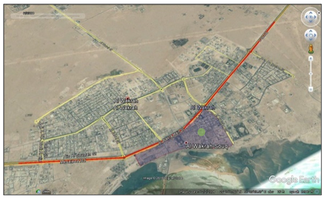
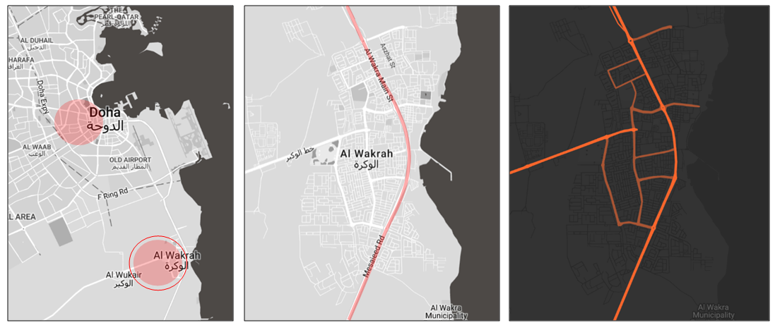 | Figure 1. Al-Wakrah city located 20 km south of Aldoha city; highlighted are the main Al-Wakrah road connecting further south to Mesaieed and the West Al-Wukair road connecting to the Al-Wukair area. Source: Author 2017 |
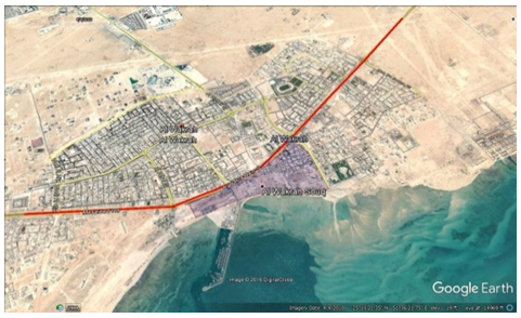
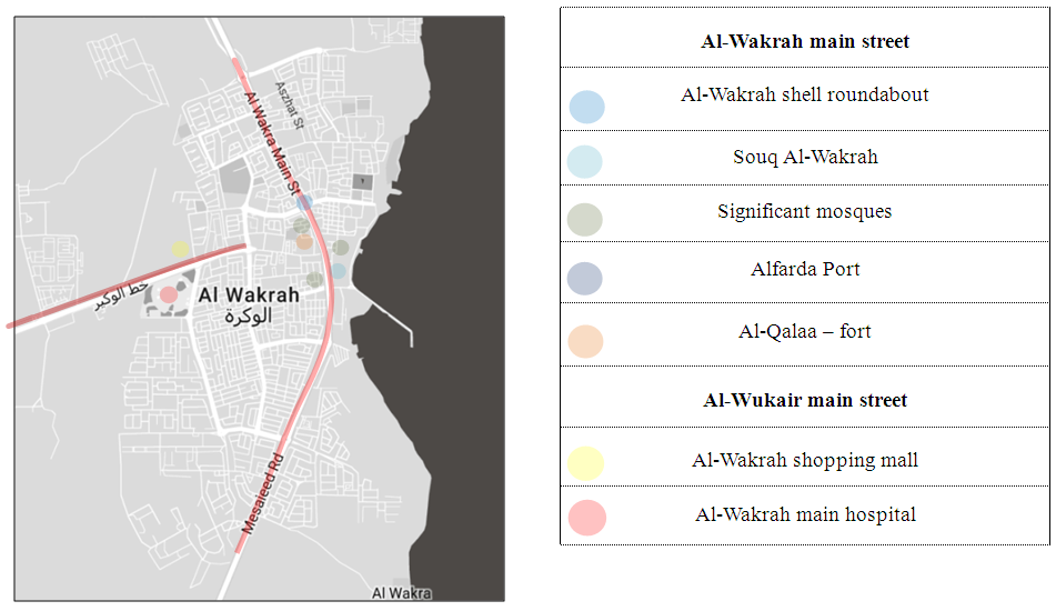 | Figure 2. Al-Wakrah main study nodes Source: Author 2017 |
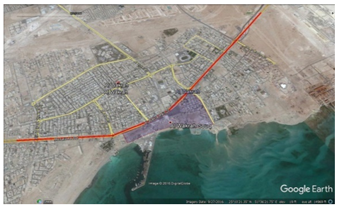
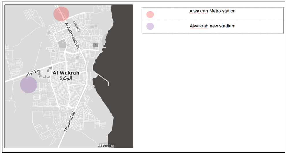 | Figure 3. Developing projects in Alwakrah Source: Author 2017 |
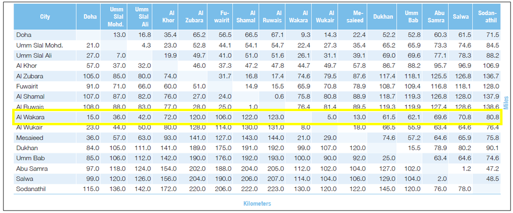 | Figure 4. Distance from major cities. Source: Ministry of Department Planning Statistics |
 (b) Satisfaction and involvement with the community
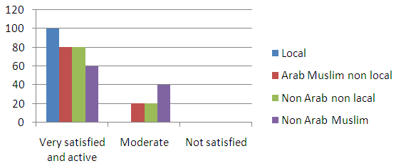 (c) The number of neighbors identifiable by first name, measuring social bonding and behavioral rootedness
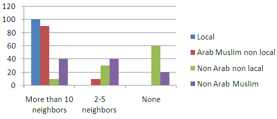 (d) Sense of relation to city forms in the context of selected urban form nodes
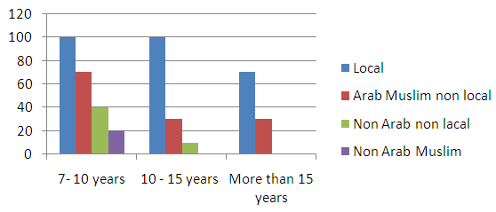
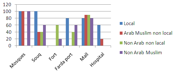 (e) Pattern of mobility—visiting the area more than once weekly
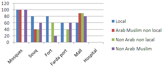 Key factors Resilience in Alwakrah is recognized as a result of interconnection of community members in relation to their environment demonstrated through physical and demographic qualities that allow them to withstand, respond to, and adapt more readily to rapid changes in the built environment. Relevant demographic factors
 | Figure 5. Al-Wakrah has 299,037 occupants (Qatar 2015): 36% Qatari nationals and 49% Muslim, 15% non-Muslim non-Qataris. Though fewer in number, locals are highly influential on the street and in modeling ethics and development. Source, Ministry of Department Planning Statistics |
 | Figure 6.1. 1940s: The road to Doha, leading out of the top of the photograph, with the square fort visible in the center |
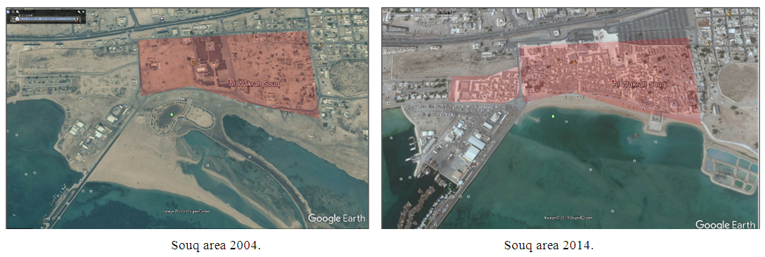
 | Figure 6.2. 2004: The road to Doha maintained and developed, at the top of the photograph, with the square fishing and pearling fort developed into a linear port (Alfarda). The development of residential blocks into land is visible, and the old town fabric is seen deteriorating |
 | Figure 6.3. 2010: Active revitalization of the old town at the souq and Farda area. The main connective tissue has maintained its original shape while development continues |
 | Figure 6.4. 2017: Recent view showing development of the souq and Farda area making it the heart of the developing city |
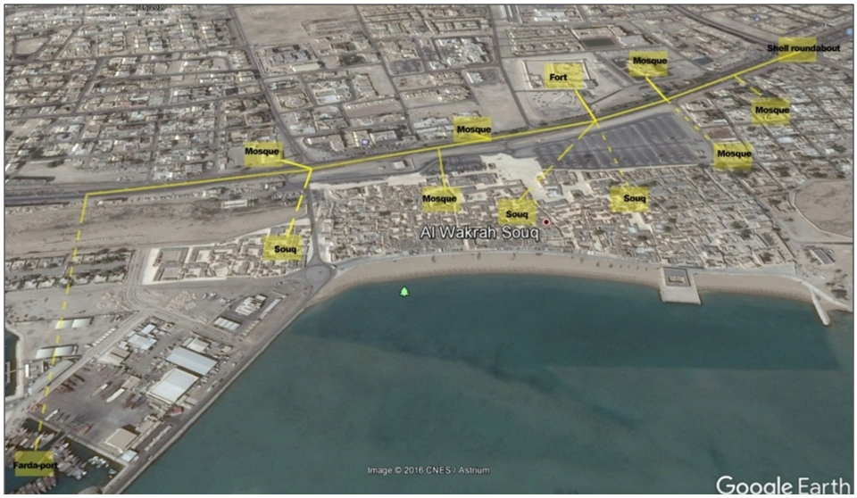 | Figure 7. Key view of nodes, with visual exposure from street level. Source: Author, 2017 |
 | Figure 8. Areas of high activity and significance in the surrounding streets. Source: Author 2017 |
 | Figure 9. Relative activity patterns related to key zones. Source: Author, 2017 |
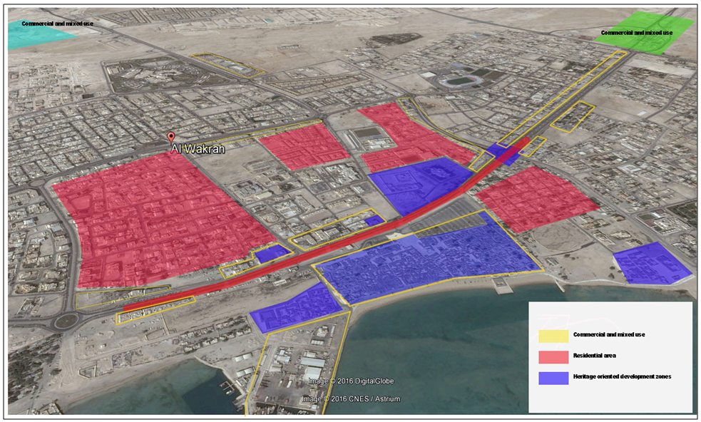 | Figure 10. General land use zoning showing residential developments around the town center Source: Author, 2017 |
 | Figure 11. Approaching shell roundabout in Al-Wakrah, with mixed-use building strips seen along the road. Shell roundabout in Al-Wakrah. Source: Author, 2017 |
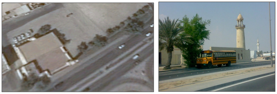
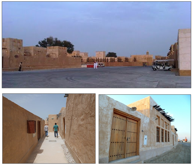
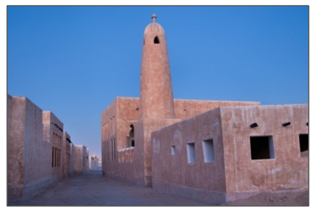 | Figure 12. Al Ayouni Mosque, constructed around 1935 in the historical town’s most active and populated section of the city, in the heart of revitalized Souq Al-Wakrah, is an important heritage site. Source: Author, 2017 |
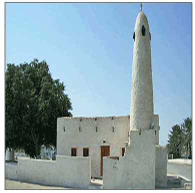 | Figure 13. The relatively small Abu Manaratain Mosque was erected in 1940, near the shore. Source: Author, 2017 |
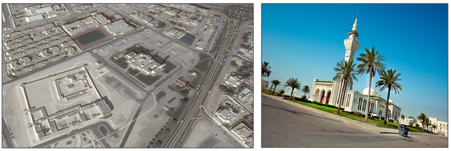 | Figure 14. Al-Wakrah Mosque near the fort, view from Al-Wakrah Street. Source: Author 2017 |
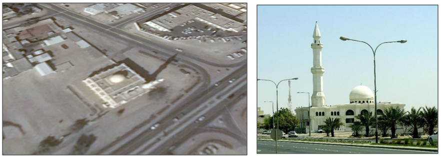 | Figure 15. Alabdulghani Mosque, view from Al-Wakrah Street. Source: Author 2017 |
 | Figure 16. Mosque on Al-Wakrah Street. Source: Author, 2017 |
 | Figure 17. Friday prayer pedestrians walking to Al-Wakrah Mosque. Source: Author, 2017 |
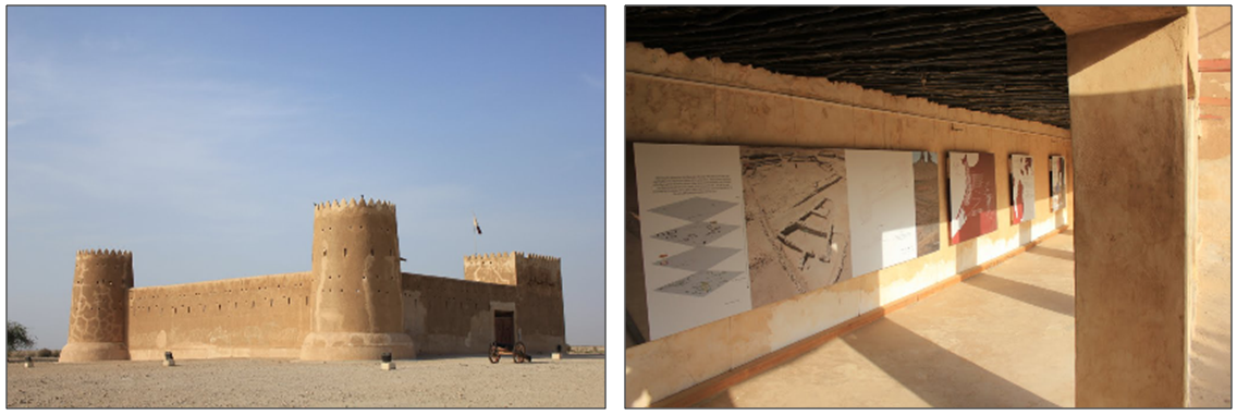 | Figure 18. The fort museum. Source: Author, 2017 |
 | Figure 19. Source: Google Earth |
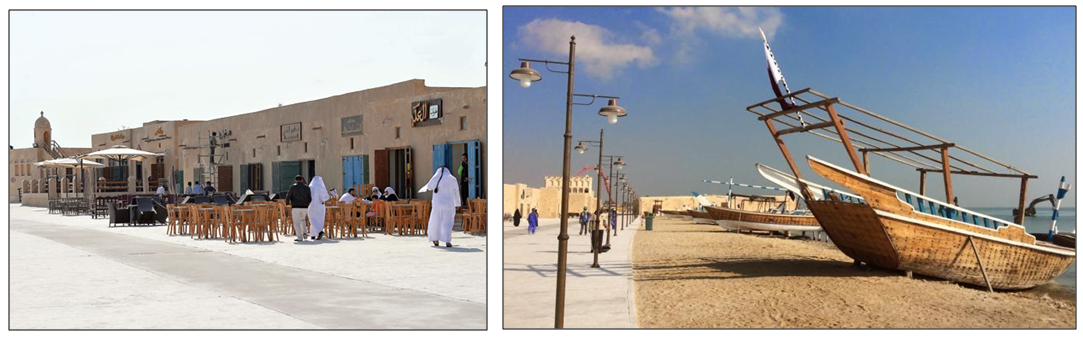 | Figure 20. Souq area. Art and heritage elements |
 | Figure 21. Green areas. Source: Author, 2017 |
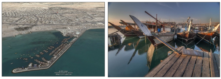 | Figure 22. The port area (Alfarada). Source: Author 2017 |
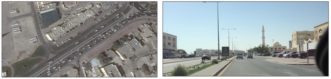 | Figure 23. Current width of the road. Source: Author, 2017 |
 | Figure 24. Optics-, place-, and content-related elements in the souq area create a sense of belonging amid memorable architecture that stimulates a sense of community. Source: Author 2017 |
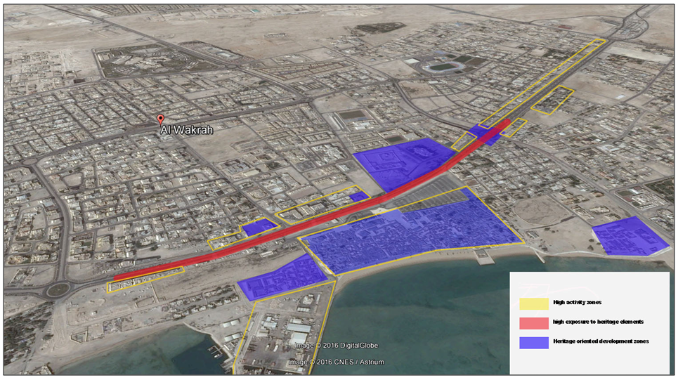
 | Figure 25. General land use zoning shows relation of residential developments around the central town. Source: Water mark Author, 2017 |
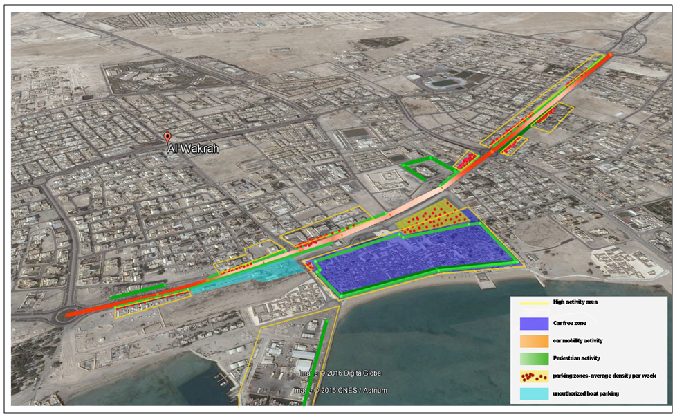
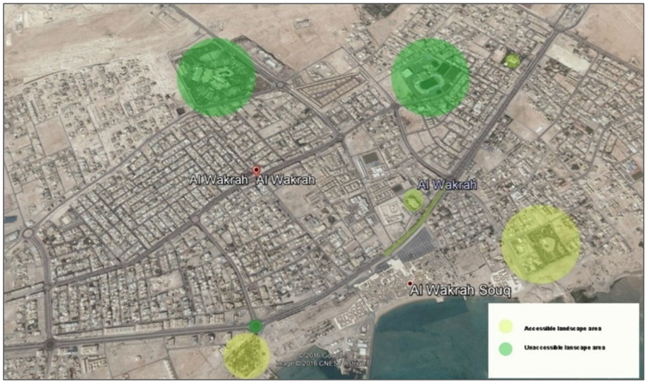
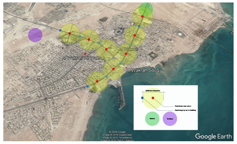
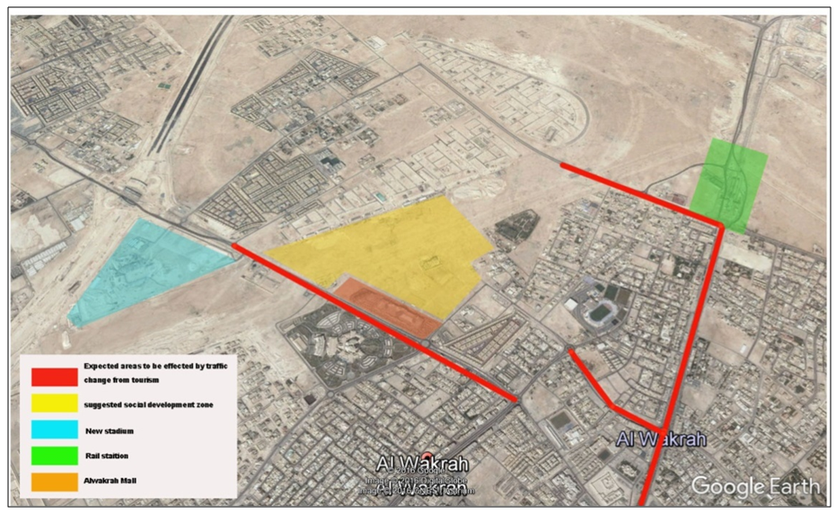 | Figure 26. The areas likely to be affected by rises in demand caused by metro and tourism development. Water mark Author, 2017 |
5. Conclusions and Discussion
- New Urbanism is one of the closely linked movements since the 1970s and 80s which offers resolutions to Alwakrah’s similar modern growth problems. “It promotes mixing residential, commercial and public spaces; mixing different housing types; narrow lots; pedestrian friendly streets; and celebrating local history, climate, ecology, and building practice” in an attempt to enhance sense of community (Talen 1999; Kim and Kaplan 2004). In Alwakrah, Locals play a dominant role in general community and city forms despite their minority numbers—and thus must be a main focus of development decisions. City centers, where retail and social entertainment activities take place and where public interactions are frequent, must take into account place, relationships and collective power when considering the community and create spaces that are suitable for original occupants of the space while embracing the needs of the future demand in tourism.Community as a PlaceUrban spaces function successfully when their design contributes to a sense of place that allows users to identify themselves with heritage and development equally. Architectural consideration of building facades—elements of heritage that reflect local building traditions—provides a constant reminder of the originality of a place to which community members can relate.Each node, when part of a large network of the community’s ground for interaction, plays a significant physical and social role in Al-Wakrah’s sense of community. Connective tissue between city nodes is a key factor in successful community development: Safe and comfortable walkable areas that connect spaces while allowing for vehicular transit and parking can determine the success of social zones.The combination of transportation with aesthetics and artwork reflects on a city’s and community’s image and culture. Stopping points in linear walking zones and linear streets increase time spent in the area, thus strengthening the social network, and should be enhanced with prominent architectural features that convey function.Creation of lively urban areas supporting continued vision and expectation is the most effective way of increasing a sense of safety and well-being (Furlan 2015).Community as RelationshipsDevelopment must consider homogeneity in light of surrounding buildings, perspective view, social manners, customs, and needs. In New Urbanism, community is achieved through tight-knit buildings and neighborhoods, and application in areas of high social activity, such as retail and leisure centers, boosts interaction between community members. Locating the most active building, such as a mosque or major retail or leisure hotspot, prominently along the street edge helps lay out the entire city: Exposing users to these forms imprints the character of both city and community. The size and scale of these buildings is important, with views varying from distant to close up, bringing compatibility between human scale and built forms by smoothly transitioning between them to develop a stronger sense of place and community. Narrow walkways that end at tall buildings leave users feeling psychological discomfort, but hierarchizing these forms can influence perceptions of the community: Heavy traffic and pedestrian activity are seen through scale and type of buildings, with large buildings usually magnets for exploration, serving as landmarks, and mosques and political buildings serving as community reminders while increasing resilience to identity loss.Community as collective powerThe following factors have heightened the community’s collective power and should be primary considerations in enhancing an area:Historic area families gave the location’s original occupants a high social status that inspires certain behavior while creating certain urban expectations. High-profile families consider built heritage and architectural elements such as the Majlis an intangible part of their daily life—and future generations’.The residential Majlis brings local nonofficial political empowerment, allowing occupants to influence decision makers’ over development such as that of the souq and Farda, forestalling rapid planning decisions that may diminish a place’s uniqueness.Ethnic similarity supports local life by increasing the interest of individuals using the space. The city’s urban fabric is the result of the specific practice and lifestyle of its occupants, as seen particularly in mosques and in residential areas’ privacy features, and creates a feeling of social and place belonging.Social economic factors significantly influence well-being as well as community members’ use of modern technologies and local assets. Equity must be a primary consideration when establishing commercial and public spaces, lest doing so decrease members’ engagement and senses of community and place.Situations that encourage locals to engage in public activity help regulate social behavior. Public areas and city centers help create a sense of well-being as examination of social interactions creates a sense of community. With the development of tourism and the coming of the metro, the community will experience changes to area density and the introduction of new behavior patterns that may diminish occupants’ well-being. Resilience can be achieved by increasing the numbers of local community members in high-interaction nodes.
6. Recommendations
- 1. Since the life style housing style preference of the community members does not follow new urbanist compactness, other solutions in the social hubs of the city are suggested to increase compact development and social engagement that increases tolerance and resilience. Three main factors will physically support community engagement in social interactions: roadway width; walkability; safety and comfort (through shading); soft scape. Local architectural and heritage considerations reflection in the physical realm must be taken into account when planning developing areas in Alwakrah. The following strategy aims to improve street walkability and accessibility while offering visual and physical interactions with existing architectural and heritage urban features.
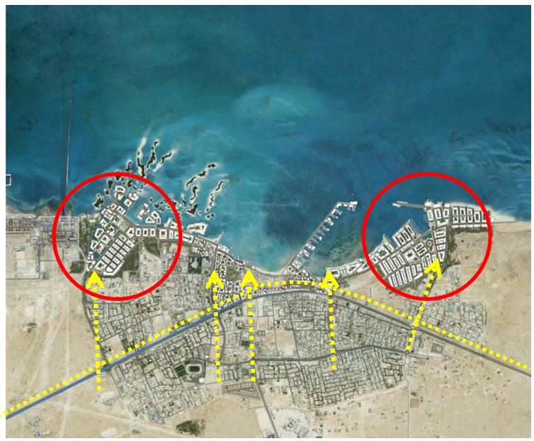 | Figure 27. City coastline development and areas considered for future planning |
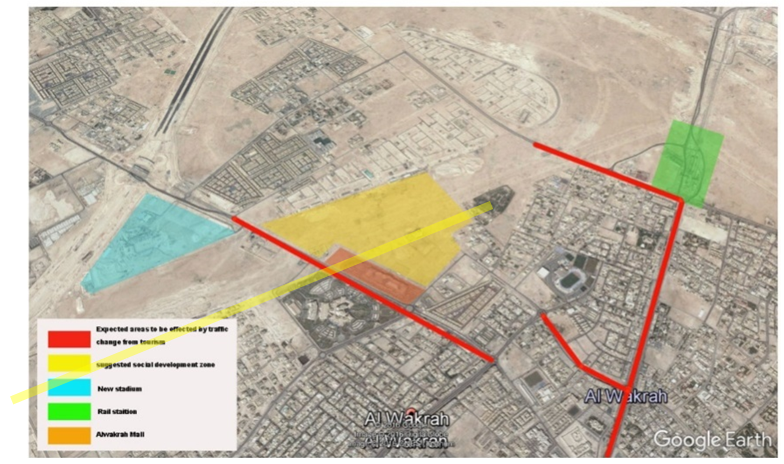 | Figure 28. The roads most likely to encounter density issues that will influence the community’s well-being. Source: Water mark Author, 2017 |
 | Figure 29. Source, Water mark Author, 2017 |
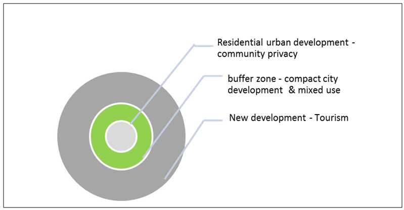 | Increasing neighborhood social space by transitioning to mega-social areas through high walkability and consideration of local architecture. |
 | The missing link between residential and main commercial hotspots. |
7. Contribution to Knowledge
- This research adds to the body of literature about Al-Wakrah city and can be considered in development plans, including for upcoming events and transit development. It also discusses relevant literature and considers social and physical aspects of the city’s development to ensure the sustainability of the local community and enhance resilience for future generations amid urban growth.
8. Implications for Practice and Advancement of Research
- The original investigation focused on the perceptions of community members, but further studies could inquire about the perceptions of all users—visitors and tourists. The development of both station and stadium should be closely monitored to uncover patterns useful for future planning.
ACKNOWLEDGMENTS
- Ms. Alfaraidy has 2 years’ experience working as an architect in Saudi Arabia, scoping and managing design, site preparation, and construction for Saudi Aramco’s residential and commercial developments. She has 2 years’ experience teaching language at Saudi Arabian charity centers and helped establish a non-profit youth organization center in Qatar. She also has 3 years’ teaching experience at engineering departments in the Royal Commission College of Engineering and at Prince Mohammed University in Saudi Arabia. Currently, she is a Master in Planning and Design candidate at Qatar University. Raffaello Furlan is an assistant professor in the Department of Architecture and Urban Planning (DAUP) at Qatar University. This research study was developed as an assignment as part of the core course Research and Statistical Analysis in Planning (MUPD601, Spring 2017) taught by Dr. Raffaello Furlan at Qatar University, College of Engineering, Department of Architecture and Urban Planning (DAUP), for the Master’s in Urban Planning and Design (MUPD) program.The authors would like to acknowledge the support of Qatar University in having created an environment that encourages scientific research. Also, they express their gratitude to the government of Qatar, and especially the Ministry of Municipality and Environment (MME), for handling relevant visual data and cardinal documents for the purpose of this research study. Finally, the authors thank the anonymous reviewers for their comments, which have improved the quality of this paper. The authors are solely responsible for the statements made herein.