Architecture Research

p-ISSN: 2168-507X    e-ISSN: 2168-5088

2017;  7(3): 69-83

doi:10.5923/j.arch.20170703.02


Strategies for the Enhancement of Users’ Interactions in Al Mirqab Al Jadeed Street in Doha, State of Qatar

Mahmoud H. Al Saeed1, Raffaello Furlan2

1Architect, AAU (Jordan), Pursuing a Master’s in Urban Planning and Design, Qatar University, State of Qatar

2College of Engineering, Department of Architecture and Urban Planning, Qatar University, State of Qatar

Correspondence to: Raffaello Furlan, College of Engineering, Department of Architecture and Urban Planning, Qatar University, State of Qatar.

Email:

Copyright © 2017 Scientific & Academic Publishing. All Rights Reserved.

This work is licensed under the Creative Commons Attribution International License (CC BY).
http://creativecommons.org/licenses/by/4.0/

Abstract

Al Mirqab Al Jadeed Street, with its unique mix of land use and geographical location, has become one of the most densely populated streets in Doha City, the capital of Qatar. Over the past few years, many establishments and transitional developments, such as various services, commercial malls, and the like, have altered Al Mirqab Al Jadeed’s urban characteristics. Moreover, this rapid development has overtaken urban spaces, leaving no place for green areas or proper urban furniture—and thus resulting in human social decay. This shortage of green areas has discouraged and diminished the quality of outdoor activity (whether in terms of walkability or social interaction) in the street, thereby affecting the quality of living, human health, social fabric, and surrounding neighborhoods. This research study investigates existing urban components (soft and hard) as well as green areas (pocket gardens, shading elements, footpaths, etc.) in the streets, considering their influence on human behavior from a social and environmental point of view. In doing so, it engages with issues of social sustainability and urban design in the context of local neighborhoods. A literature review was conducted of topics having to do with sustainable development (social sustainability) and principles of urban design, exploring the body of knowledge about sustainable development. Accordingly, site observation and analysis, together with in-depth interviews, have been adopted as the main research methods, so to highlight the street urban fabric while simultaneously enhancing quality of life and social interactions in Al Mirqab Al Jadeed Street. The findings of this study elucidate the connection between social sustainability and urban design standards, shedding light on the effect of built forms on user behavior and thereby contributing to the body of knowledge about socially sustainable development and urban design. In doing so, they support the application of theoretical knowledge on a practical level and in real-world scenarios.

Keywords: Al Mirqab Al Jadeed Street, Social sustainability, Urban design, Social interactions, Urban fabric, Doha, Qatar

Cite this paper: Mahmoud H. Al Saeed, Raffaello Furlan, Strategies for the Enhancement of Users’ Interactions in Al Mirqab Al Jadeed Street in Doha, State of Qatar, Architecture Research, Vol. 7 No. 3, 2017, pp. 69-83. doi: 10.5923/j.arch.20170703.02.

1. Introduction

The GCC countries have been growing rapidly over a very short period: The discovery of “black gold” has led to explosive urban growth. The state of Qatar is in many ways no different from other GCC countries in having adopted its own economic strategies that aim to adapt to and indeed encourage rapid urban growth. In the 21st century, Qatar entered an era of modern urbanization, driven by the promise of greater oil production. (Fromherz, 2012; Jaidah & Bourennane, 2010; Jodidio & Halbe, 2015; Qatar, 2008; Salama & Wiedmann, 2013) This growth has also had negative effects, such as neglect of the natural environment as well as of well-being and quality of life within the built environment of Doha. (Furlan & Almohannadi, 2016; Furlan, Muneerudeen, & Khani, 2016; Furlan & Sipe, 2017; Furlan & Wadi, 2017; Furlan, Zaina, & Zaina, 2016) Al Mirqab Al Jadeed Street (MJ Street) is one of the major streets of the Al Mirqab district (Figure 1). The street was designed in the late 1980s to create a neighborhood for growing commercial and residential activities. In the period 2005–2017, several services and commercial establishments were also founded, such as the Doha Souq Mall and the Al Doha Clinic Hospital. The well-known Al Mirqab Shopping Mall is found along this spacious street, as are many other establishments. Various land uses can be seen giving rise to a rapidly expanding range of activities (residential, commercial, mixed-use, governmental services). The street fronts 12 housing units and 75 commercial establishments. (Authority, 2010) Almost 2,000 people live in the settlement, (statistics, 2015) of whom 61% are male and 39% female. Fully 60% of the total population is made up of employees, including both visiting workers and permanent residents.
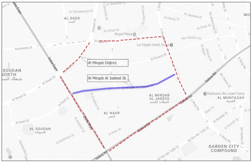
Figure 1. Al Mirqab Al Jadeed Street within the Al Mirqab district limits (Source: Author, 2017)
As rapid urban development has overtaken urban spaces, sacrifices have been made. Burgeoning building projects, such as skyscrapers and housing, have prevented the development of sustainable and friendly pedestrian environments. As a result, the Al Mirqab growth zone has been suffering from a shortage of green landscape that is itself directly linked to the frequency and intensity of users’ social interactions (Furlan, 2015, 2016; Furlan & Faggion, 2017; Furlan, Muneerudeen, et al., 2016; Furlan, N. Eiraibe, & AL-Malki, 2015; Furlan, Nafi, & Alattar, 2015; Furlan & Petruccioli, 2016).
This research study focuses on MJ Street in Doha, investigating how environmental aspects are linked to the social interactions of users, as well as to what extent health and social activities, furniture, streetscapes, pocket gardens, and pedestrian networks enhance quality of life (Adhya, Plowright, & Stevens, 2014; AlSayyad, 1991; Day, 2003; Farr, 20081; Furlan & Mogra, 2017; Furlan, Muneerudeen, et al., 2016; Furlan, N. Eiraibe, et al., 2015; Furlan, Rajan, & AlNuaimi, 2016; Hakim, 2014; Wiedmann, Salama, & Mirincheva, 2014). In developing a systemic set of strategies to address these issues using practical and applicable methods, the authors seek to create a practical approach that will rely on various classifications. Beginning strategies will address social needs, responding to the question of how to develop and increase the interactions of residents with each other as well as with built forms. Meanwhile, the environmental approach aims to resolve arising issues surrounding leakage of green areas by seeking an answer to the question of how to use and enhance urban leftover space for the benefit of both the environment and its users. The authors link these strategies with the potential for street development, asking how to apply these recommendations to the existing urban fabric of MJ Street. This research thus responds to and illuminates both issues of methodology and strategies for enhancing social interactions.

2. Background

Social Sustainability
Cities are geographical settlements inhabited by a group of people that fulfill the needs of their users either physically or psychologically even as the size of the settlement grows with its population (Stevenson, 2013). Today, 54% of the world’s population lives in urbanized areas (United Nations, 2016), This continuous population growth in urbanized areas has prompted concerns about cities’ ability to achieve self-sufficiency without abandoning user satisfaction or quality of life.
Humans’ gregariousness gives rise to cities. At first in tribal and communal contexts, humans’ mutual support allowed the accumulation of surplus and the attendant formation of hierarchical societies that in turn supported consolidation into villages, towns, and eventually cities. (Brown & Dixon, 2014) Indeed, cities are places where emotions and sociological aspects are balanced. (Landry, 2006, p. 11)
The definition of social sustainability is a point of contention among scholars, some of whom argue that it indicates the zone created by the intersection of economic growth, social development, and environmental protection:
(First model: Intersected circles- the Venn model) Venn diagram suggests that there are potential positive-sum “win–win” calculations in the overlaps including areas outside that need periodization. If each of the circles is associated with the intersects of particular stakeholders/actors at whatever level of intervention, then the areas of overlap represent potential spheres of cooperation or partnership. (Meadowcroft, 1999)
According to the Rio Declaration (1992), sustainable development is all about balancing and sustaining three-dimensional issues in all their interconnectedness so as to achieve a sort of process prioritization (Figure 2). (Manzi, Lucas, Jones, & Allen, 2010)
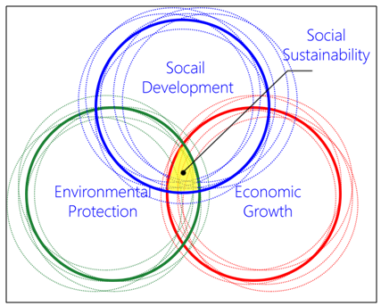
Figure 2. A Venn diagram explains the circles of social sustainability (Source: O’Ridan, 1998)
(Second model: Overlapping circles—the Russian doll model): Although the Russian doll model minimizes governance and negotiation as elements of sustainable development, we argue that these areas are central to any understanding of social sustainability—and, moreover, that the concept can be understood by distinguishing between ecocentric and anthropocentric approaches to the question. (Kearns & Turok, 2003) Such a model emphasizes the importance of efficient use of resources and fundamentally derives from environmental movements (Figure 3). (Manzi et al., 2010)
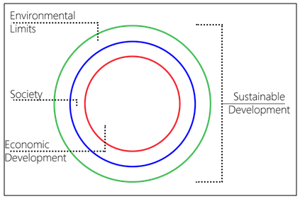
Figure 3. Russian doll model of overlapping circles (Source: O’Ridan, 1998)
(Third model: Three-dimensional intersections): Jarvis, however, explains that social sustainability chiefly concerns itself with the interconnectedness of individuals’ actions and the created environment in which those actions occur—the link between individual life and institutional structure. Such a perspective, he notes, has been taken all too infrequently by mainstream voices in the debate over issues of sustainability (Figure 4). (Manzi et al., 2010)
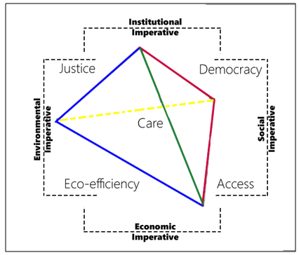
Figure 4. The Jarvis model (Source: O’Ridan, 1998)
These models situate their definitions of social sustainability in the importance of finding common ground between community and other motivators, such as the economic, social, environment, participation, and policy.
Social sustainability is possible when human needs are provided for through an institutional framework that takes into account considerations of productivity and social equity while keeping the human factor at the forefront. (Littig & Grießler, 2005) Brundtland describes the main principles of sustainable development as follows: (Barton, 2000)
Public trust: Resources must be preserved on behalf of the public and for its benefit.
Intergenerational equity: Contemporary decisions must not deprive future generations.
Subsidiarity: All parties to a decision must engage with all stakeholders.
The polluter pays: Environmental damage must be rectified, with polluters paying the recompense for their ignorance—whether by giving back to society or paying fines to be used for the same purpose.
Both Article 2 of the 1997 Amsterdam agreement and the 1998 Aarhus convention, drawing inspiration from European Union institutional bodies, discussed ways of bringing about sustainable development. Indeed, the European Union’s first sustainable development strategy was formulated based on the Lisbon strategy of 2000 (EU Commission, 2004), reflecting the Millennium Development Goals, and itself brought about a global commitment to creating a space for developing countries in the sphere of international trade. This gave rise to policies designed to address issues of unsustainability while implementing mutually reinforcing economic, social, and environmental policies.
The Qatar National Vision (QNV) for 2030, for its part, has built on the four tenets of human, social, economic, and environmental development in promoting sustainable development among the mainstream. Well aware of the challenges facing Qatar, the QNV sees national development as most appropriately being carried out responsibly and respectfully in ways that harmonize the economic, social, and environmental dimensions of life. It emphasizes the urgency of forging regional and international alliances that promote global development through partnership. The Qatari government’s ambitious agenda, however, will require deep-seated organizational changes and substantial capacity-building among the institutions responsible for environmental issues. Indeed, although many governmental entities as well as the private sector will be involved in this initiative, the Ministry of the Environment will assume a primary role, being responsible for recruiting scientists and technical specialists who can conduct research and monitoring and facilitate regulation. In all this, the ministry will continue collaborating closely with other governmental units.
Urban design
Urban design aims to develop a functional, attractive, satisfying, and sustainable settlement. Accordingly, it can be defined as a multidisciplinary subject that relies on all elements of built form engineering, including architecture, landscape design, urban planning, and general municipal engineering. (Van Assche, Beunen, Duineveld, & de Jong, 2013)
The design of the public realm arises from the public spaces and the buildings that give them their meaning. Urban design takes a holistic view of these spaces, seeking to bring together as part of a unified vision the various disciplines that contribute to a city. Unlike a more comprehensive plan, urban design is usually focused on the short term and on a specific area or project (Association, 2006). Positive changes can be taken into consideration for the human welfare, but urban designers must take responsibility for reshaping the human life style to achieve the maximum benefits of the users. (Brown & Dixon, 2014) For example, an urban development designed in an era of climate change—and in a hot region, no less—must take a fresh view of climatic considerations. (Givoni, 1998) Urban site boundaries, moreover, exceed horizontal spatial dimensions to include vertical dimensions as well. (T. Oke, 2006) Urban geometry and profiles—whether shapes or heights, sizes of buildings or orientations of streets, or the very nature of the surfaces in urban open areas—are factors affecting the urban climate. Accordingly, each urban manmade element (typical building, street, parking lot, industrial building, etc.) goes beyond itself to shape a climate made unique by its characteristics. (Givoni, 1998) Thus “urban designers can create favorable microclimatic conditions in and around buildings, and in outdoor spaces to dramatically increase comfort and reduce building energy requirements” (Donald Watson, 2003) What’s more, with respect to neighborhood platforms as an urban unit for the city, there is no defined area for a neighborhood; it can be defined through the concept of a 5-10 minutes’ walk from its perimeter towards its civic center, and can be defined with relation to the cities’ utilities or separately (Ramadan, 2010). Thus, the characteristics of an urban open space are edges, floorscape, and urban furniture. Edges are the linear components that define and encase space which incorporate building facades, screen walls, trees, shrubs, change in floor level, ground modeling, and shorelines (Lynch, 1960). Both hardscape pavements and softscape cover merge to define the edges of a floorscape that covers the surface of the ground. (Moughtin, Oc, & Tiesdell, 1999) However, vegetation can include natural elements that can be placed vertically or horizontally among built forms to maximize the benefits offered by a particular view, to enhance thermal comfort, to boost users’ health, or to promote urban forestry. Distances between pairs of public greens average 600 meters, halfway between the 300 meters of English nature standards and the 15 minutes’ walk, or 900 meters, recommended by the European Environment Agency. (Barbosa et al., 2007)
Parks are green landscapes that should be placed in harmony with one another while representing the distinguishing characteristics of the place where they are. A park may include a playground, water features, shade structures, and architectural features such as kiosks, toilets, and monuments, as well as bicycle and pedestrian paths, plazas, and seating areas. Pocket gardens are a series of medium-sized to small parks that include children’s play areas, shade structures, and other amenities.
(A) Trees: Urban microclimate performance in a built environment can be enhanced and improved through the planting of urban trees, which can decrease energy consumption, especially in residential buildings. (T. R. Oke, Crowther, McNaughton, Monteith, & Gardiner, 1989) Less heating of the surrounding air is then seen, heightening comfort levels outdoors as well as in by modifying ambient conditions. (Taha, 1997) In one example, urban trees were arranged so that a completion of the UC spaces is achieved alongside with the sheltering effect which also decreases exposure time to short wave solar radiation . . . . This is introduced as a tree green color percentage of not less than 33% of any canyon’s. (Fahmy & Sharples, 2009)
(B) Ground cover: Pavement and buildings absorb heat during the daytime and release it at night, making city environments hotter than suburban areas). Gulyás, Unger, & Matzarakis, 2006 (Even so (Figure 5), the climatic benefit of landscaped ground cover is seldom considered. On a sunny summer day, an acre of turf may evaporate about 2400 gallons of water. At this rate, the rear yard of a typical 1/4 acre lot will have the cooling effect of 2 million Btu per day, as this has a significant influence on air temperature. In similar terms, the daily evaporation from a mature beech tree is said to provide an air cooling effect of one million Btu— which is equivalent to 10 room-sized air conditioners operating 20 hours a day. The difference in surface temperature between grass and asphalt can easily exceed 25°F. (Donald Watson, 2003)
(C) Street planting: Street trees should typically be upright, branching above 2.4 meters to provide adequate walking clearance. Trees frame the street and improve the quality of pedestrian movement. Selection of species of tree will be determined with reference to certain factors: (1) road width, (2) available space for planting, (3) adjacent land use, and (4) surrounding activity. (Marg, 2012)
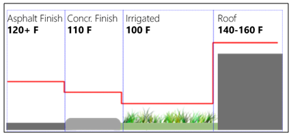
Figure 5. Temperature differences for different surface materials
Streets are the lifeblood of our communities and the foundation of our urban economies. They make up more than 80 percent of all public spaces in cities and have the potential to foster business activities, and serve as a front yard for residents, and provide a safe haven for people to get around easier, whether on foot, bicycle, car, or public transportation. The vitality of urban life demands a design approach sensitive to the multi-faceted role which streets play in our cities. (NACTO, 2016)
Because walking is the most widely used means of transportation—and is also the most sustainable method of moving around, considering that all journeys begin and end on foot—designers of sidewalks take into consideration the high priority of allocating pedestrian paths so as to decrease use of cars, which should be used only for short journeys (Figure 6). (Department of Transport, 2013)
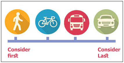
Figure 6. Transportation prioritization chart explaining the Priority of each type of transportation (Source: NACTO, 2016)
Footpath: Should provide clear and unobstructed minimum walking zones 2 meters wide with 2.4 meters’ vertical clearance. The design of footpaths should be convenient for pedestrians while allowing vehicular access to adjoining properties (Figure 7). (Marg, 2012)
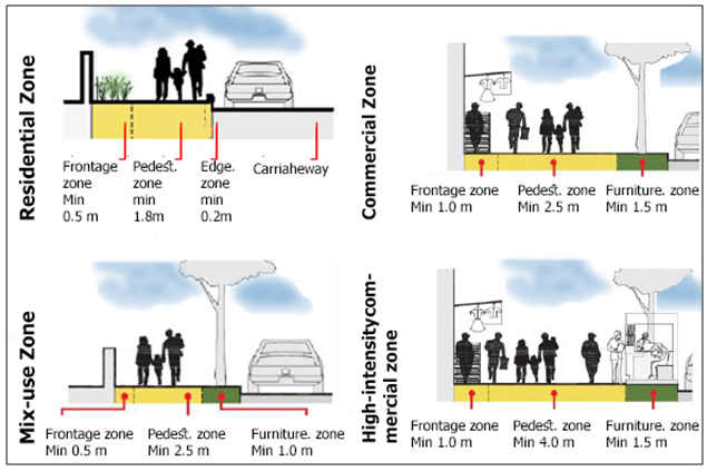
Figure 7. Pedestrian walkway dimensions (Source: NACTO, 2016)
Cycle tracks: Clear unobstructed cycling zones should be at least 2 meters wide if used for unidirectional movement and at least 3 meters wide if used for bidirectional movement and should have vertical clearance of 2.4 meters (Figure 8). (Marg, 2012)
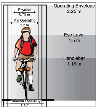
Figure 8. Cycle tracks dimension (Source: NACTO, 2016)
Street furniture: Street furniture caters to road users’ need for comfort, especially pedestrians’ and cyclists’, and thus should be made of durable material, easy and cheap to maintain, safe to use, easily accessible for purposes of repair and replacement, and aesthetically pleasing. All street furniture should be placed so as to allow all access needed for street cleaning. (Marg, 2012) City furniture should be placed within 450 meters of shading devices. (GORD, 2105)
A generalized definition of social sustainability is hard to obtain, for each scholar or policymaker chooses a definition appropriate to a specific condition and to fit a certain case, specifying a certain criterion or study perspective. Notwithstanding, social sustainability is an independent category distinct from sustainable development.
When healthy and lively communities are founded and supported by all systems within the same socially sustainable community, current and future generations have equal chances of consuming the same amounts of resources while still reducing energy waste. City vegetation and hardscape encourage participation and engagement among the community on both the social and the physical levels, introducing the concept of a 5-10 min walk every day as a means of changing the lifestyle of the community as a whole—an important consideration for officials. The physical relationship between green set and built forms decides the degree to which a city is pedestrian-friendly.

3. Methodology

According to Schindler and Cooper (2011); Ghauri and Gronhaug (2005); Dawson (2002) that research is a scientific and systematic search for relevant information on a specific topic. In other words of Schindler and Cooper (2011) that research is “a process through which a researcher will make plans and strategies in order to answer the research questions and achieve objectives of the research”.
This research paper examines the relationships between the physical and nonphysical aspects of built form, investigating their influence on the inhabitants of a location, for that purpose the authors uses quantitative methods to assess the data collected from various sources related to the chosen research subject and point of interest, the type of collected data focuses on numbers and statistics which has been collected by the authors as a primary source of data nevertheless government annual statistics used as secondary type of data. In order to collect such data a period of four months (January-April, 2017) was dedicated for that purpose.
Al Mirqab Al Jadeed Street was chosen as the research area for its major role in the local economy. Its location makes it one of the mostly densely populated, and thus most desirable, streets for multipurpose use. In sum, this research employs three kinds of data collection and analysis (Figure 9).
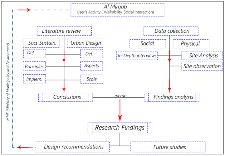
Figure 9. Overall process chart (Source: Authors, 2017)
Site analysis
This analysis investigated and assessed physical conditions on the street, including aspects such as density (pedestrian and vehicular), land use, physical conditions of the built environment, and availability of both hard- and softscape (green set, public realm, connection set, and parking), as well as their influence on user behavior. This physical analysis allows characterization of the street into subzones on a scale of poor to acceptable levels of activity.
Site observation
Direct observation creates an understanding of how demographic characteristics such as race and gender affect the distribution of user activities (through walkability and social interactions) and the conditions under which those activities increase. A table of the reasons that underlie increases in activity can be linked to physical analysis of a site.
In-depth interviews
In one method, the authors will use unstructured and in-depth interviews (nonstandardized) as a face-to-face source of data. This data, which will normally be analysed qualitatively, will be referred to as qualitative research interviews. Because the research paper deals with existing built forms, the interviews will be exploratory, and the collected data will be analysed both qualitatively and quantitatively. Interview questions will be divided into three sets of different categories driven by interviewees’ type of participation: (1) permanent users, who are residents of the area; (2) semi-permanent users, including employees and workers who usually spend more than 8 hours a day in the zone; and (3) visitors who come for a specific reason, such as to engage in commercial activity or to obtain general services.
The first set of questions focuses on the disadvantages of environmental aspects such as the availability of green areas and their effect on the inhabitant satisfaction level, whereas the second set is more linked to the type of interaction with built and nonbuilt forms. The questions will be used to explore interactions between users (social interaction) and of users with the urban fabric (physical interaction). A third type of question will determine A responsible (environmentally and commercially) level of enhancement that will be used as the design benchmark by examining the present status of MJ-street with pre-set locations (familiar locations such as main parks, shopping streets, and relevant scenarios) to achieve necessary levels of user satisfaction as measured by users’ response and while using appropriate design standards. All these categories will employ open-ended questions to encourage interviewees to express their needs clearly and without limitation.

4. Findings

This section relates to the research findings by revisiting the researched points of interest and answering the questions that arose, as well as by examining the hypotheses through an analysis of the collected data. It also reflects on the literature and suggests a scope for further research into the subject under investigation.
Site analysis
The Study Area
The street encompasses 77 establishments accommodated by approximately 155.5 acres of land on a stretch, 1.75 km long. MJ Street includes major establishments such as Doha Souq Mall, Al Mirqab Mall, the Doha Clinic Hospital, 25 service agencies, and more than 20 restaurants. MJ Street divides Al Mirqab district into the Al Naser and Al Mirqab Al Jadeed sub-districts, connecting C Ring Road with the Doha Expressway (Figure 10).
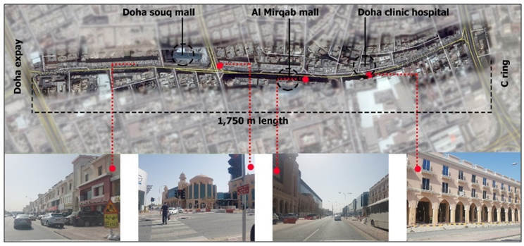
Figure 10. MJ Street geographical parameters and location (Source: Author, 2017)
Context
Site physical analysis (land use, density, physical conditions, availability of soft-scape and hard-scape)
MJ Street land use can be categorized into (1) mixed-use buildings located on both sides of the street at a maximum depth of 18 meters, including two types of mixed-use establishments—(a) commercial shops on the ground floor and residences on the upper floors, no more than four stories high, and (b) commercial shops and offices no more than four stories high: types that together comprise more than 80% of the total land use on street fronts—and (2) high-density residential buildings in the second row of the establishments, no more than seven floors high (Figure 11).
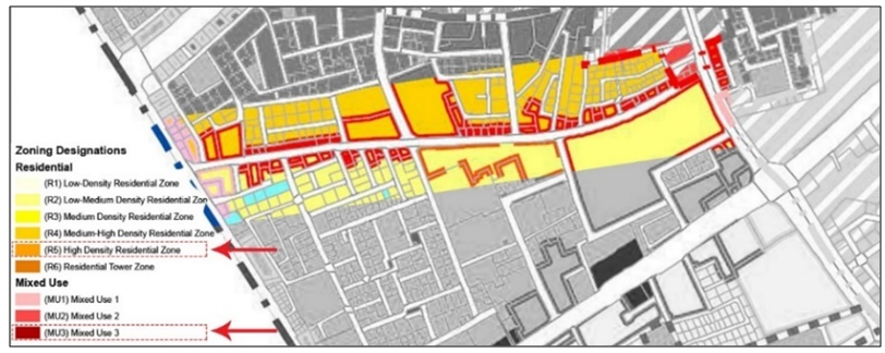
Figure 11. Land use classification along MJ Street (Source: MME, 2015)
Density: MJ Street is one of the densest streets in Al Mirqab, and its street density can be broken down into three types: (1) The built environment (building) location and footprint exceeds 85% of the total street land area (Figure 12); (2) Pedestrian uses have been rapidly increasing, along with related services such as locations of malls, restaurants, pantries, and daily services (Figure 13). (3) Vehicular density and street movement, as expected, have increased with increases in the density of built forms and pedestrian use. Street widths have failed, in some cases, to accommodate needed vehicular movement, causing serious traffic jams and crossover into parking spaces that has led to encroachment on footpaths. The current situation includes mixed-direction vehicular movement with a capacity for double lanes generally but for four lanes in some parts, especially at traffic signals that have been installed at street intersections (Figures 14 and 15).
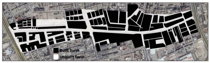
Figure 12. Built form density solid and void ratio (Source: Author, 2017)
Figure 13. Pedestrian density across MJ Street (Source: Author, 2017)
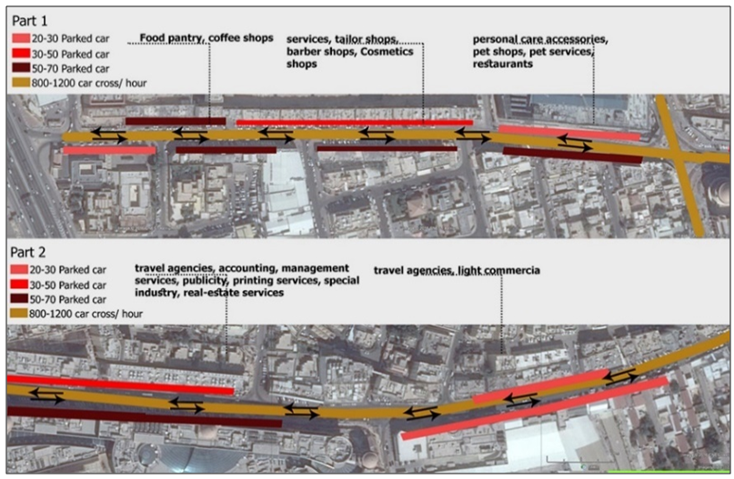
Figure 14. Vehicular density and movement directions across MJ Street (Source: Author, 2017)
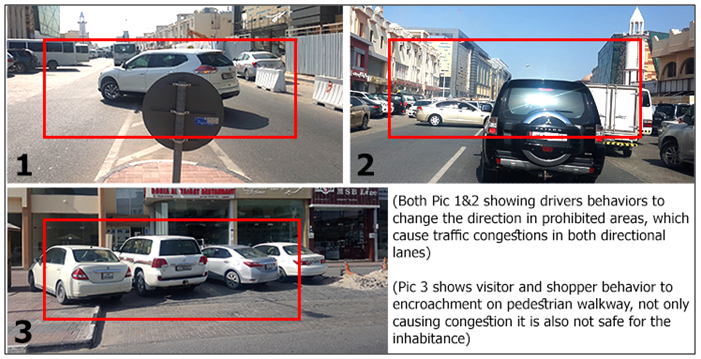
Figure 15. Vehicular encroachment on pedestrian paths (Source: Author, 2017)
Physical condition: When evaluating the physical situation (building age, finishing materials, and architectural styles) of the built forms in MJ Street, three classifications can be made. New buildings in excellent physical condition include the malls and shops that occupy more than 35% of street front capacity, whereas buildings in good condition take up an even greater percentage at 45%, leaving 20% that are in mediocre physical condition—these stakeholders have attempted to renovate, rebuilding old buildings to increase their economic benefits because of their strategic location, which increases the demand for new buildings.
Availability of soft- and hardscape: From an environmental point of view, when considering the availability of softscape bodies and infrastructure, MJ Street suffers from a serious absence of any type of green setting (floor vegetation, vertical vegetation, trees, ground cover), with only 1% of the street-front vegetated; even the pedestrian paths extending along both sides of the street are without covering vegetation or other shading elements. Pedestrians thus use hardscape on the street despite the existence of footpaths, and vehicular density in turn has bled onto footpaths, leaving only a narrow space for use by visitors and other users of the street in addition to creating leakage between softscape and hardscape. Although shading elements and street furniture are indeed missing, this leakage can be linked to owners’ and other stakeholders’ strategies for maximizing their own benefits by keeping down the costs of construction and to municipal planning’s focus on vehicular paths in a bid to decrease traffic congestion by giving priority to vehicular transportation (Figure 16).
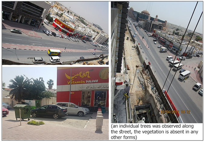
Figure 16. Monitoring the availability of both hardscape and softscape (Source: Author, 2017)
Site observation (compositions and social interaction)
The varying commercial activities in the street attract different types of users depending on their destination, with almost 85% of street inhabitants temporary visitors seeking the different services that the street offers (shopping, food pantries, and service agencies), a percentage that varies by time of day:
(1) From 12:00 until 15:00, employees in surrounding zones leave for their lunch breaks.
(2) From 18:00 until 20:00, numbers of visitors increased as a result of the presence of shopping services. These visitors were not limited to any specific nationality or group (Asian, Indian, Qatari, European) and were all engaged in and influenced by the wide range of commercial activities. However, each specific group was drawn by the presence of specific services—for example, Indian visitors mainly gathered around Indian restaurants, whereas visitors of Qatari and other Middle Eastern nationalities usually sought out Turkish food courts.
(Working hours and street daily life cycle): Analysis of the street’s daily life cycle highlights and lends itself to categorization of working hours and their relationship to visitor density levels for the almost 12 hours each day that can be considered “business hours.” Figure 17 was prepared using the results of observations and interviews of shop owners and street visitors. Commercial activity peaks once in the morning, when agencies are open for work, and again at lunchtime because of the restaurants and food pantries that attract employees from surrounding neighborhoods, then gradually increases until evening, when its reaches its maximum as visitors come for shopping purposes (Figure 18).
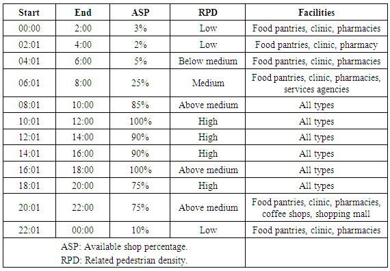
Figure 17. Daily operating hours (Source: Author, 2017)
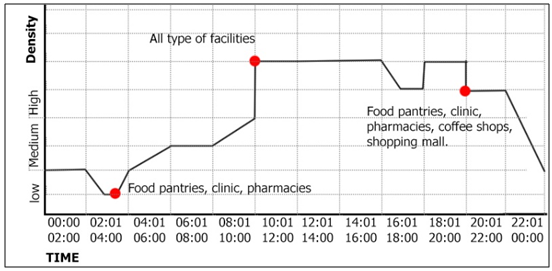
Figure 18. The daily life cycle of the street (Source: Author, 2017)
In-depth interviews and social patterns
As noted in the methodology section, these interviews focused on three different classes of participants: (1) permanent users, (2) semi-permanent users, and (3) visitors who come for a specific purpose. The data obtained through these interviews can be divided into social and environmental findings, both of which can influence inhabitants’ behaviors.
(A) Social aspects: 75% of inhabitants are familiar with their next-door neighbors in the same building, but only 15% know the residents of buildings within a radius of 250 meters — and just 10% their neighbors in the same neighborhood within a radius of 500 meters. Even so, although 35% wish to walk in the street, engaging in physical activity (sports), they do so privately and in the evenings. Fully 35% agree that the municipality should implement laws designed to structure commercial activities, but the remainder accept these in their current role, happy to see such a wide variety of services in one place. Only few interviewees showed any concern about the race of those working or living in their neighborhood or on their street.
(B) Environmental aspects: Inhabitants of MJ Street preferred more water features, greenery, and vegetation — such as trees and, on a small scale, ground cover—than did residents of other streets and neighborhoods. Moreover, they agreed in wanting more shading elements along both sides of the street as well as the presence of safe and continuous footpaths. Sustainable means of transportation, such as cycling paths, did not draw their attention even though they were aware that such transportation helps decrease vehicular traffic as well as pollution. Rather, they preferred to have an organized system of parking that would prevent encroachment on pedestrian paths. Chairs and benches they found important, thinking them best allocated no farther than 5 minutes’ walk from each other, for use as resting points in the street.
Strategies and recommendations
This section offers recommendations for generalizing these results and the findings of data analysis, describing three practical systematic strategies for enhancing, establishing, and encouraging various types of interactions, both physical and social, in the street. The first recommendation focuses on how to organize and facilitate commercial activity that directly affects the quality and quantity of social behaviors arising between users and built forms. The second and third recommendations, for their parts, look to physical principles of urban design to enhance the environmental and social aspects of interaction.
First strategy (Commercial activity): Being the street considered a high-density mixed-use commercial area, which attracts a wide range of users, decreasing social privacy, the need to organize more activities so as to achieve maximal economic benefit must also be balanced with the amounts and types of these activities. In contrast with the current situation, these recommendations advise the creation of land use groups, each of which would be dedicated to one type of activity, in turn supporting its sub-activities. Each group would operate at specific times and in specific locations. Such an approach should separate formal workplace activities from residents and families, creating a private atmosphere that encourages social interactions between neighbors. Figure 18 proposes just such a system.
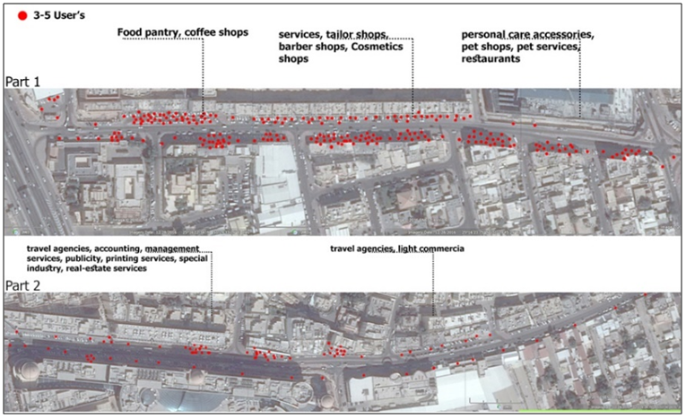
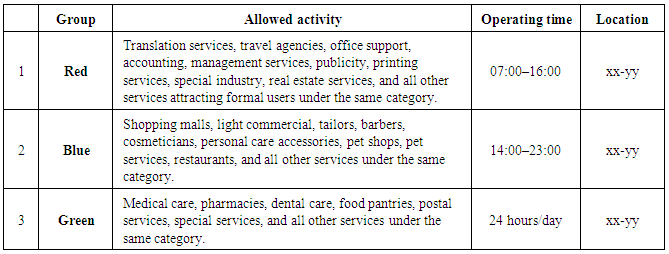
Figure 19. Group categorization (Source: Author, 2017)
Second strategy (physical aspects): The geographical location of MJ Street, which connects two major highways, Doha Expressway and C Ring Road, has made it into a transitional street: vehicular movement between Doha Expressway and C Ring Road, together with street vehicle users, has increased traffic to the point of congestion, posing serious environmental issues (CO2 emissions, noise pollution, heat radiation). Although traffic signals have been installed to reduce congestion, they have failed to address the number of vehicles that cross the street concurrently on both sides (round trip). In order to organize traffic and reduce congestion, the street requires the elimination of one type of vehicular movement, considering that there is more than one way of reaching C Ring Road from the Doha Expressway. This could be done by eliminating the connection between Doha Expressway and C Ring Road from the Doha Expressway’s side, while retaining it in the other direction. Doing so would reduce the number of cars entering the street from both sides while also providing additional space for other services. Specific times would be allotted for larger services vehicles to move around, with penalties applied to vehicles entering the street outside these hours (Figure 20).
Figure 20. Proposed circulation on MJ Street (Source: Author, 2017)
Third strategy (environmental aspects): MJ Street is suffering from environmental pollution of light, noise, and air as well as through leaks of underground and surface-level relieving systems—all of which reduce built forms’ effect on users’ health and well-being. The recommendations advise the addition of the following:
i. Shading elements: Provided by shop operators to cover pedestrian paths and as freestanding decorative shading elements by the municipal infrastructure.
ii. Vertical vegetation: Incentivized by regulations (in give-and-take scenarios) guiding owners to provide and use green facade elements and thereby reduce surface temperatures and mitigate the heat island effect, encouraging users to engage with built forms.
iii. Horizontal vegetation: Use of remaining free space to implement ground cover vegetation that would work as a relieving system to reduce environmental complications and maximize benefits, encouraging interactions between built forms and users.
iv. Pedestrian pathways: Development of continuous safe pedestrian pathways with an eye to connectivity and acceptability on all levels and for all types of users, including children and people who have special needs (Figure 21).
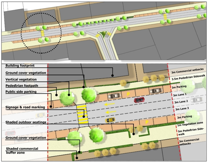
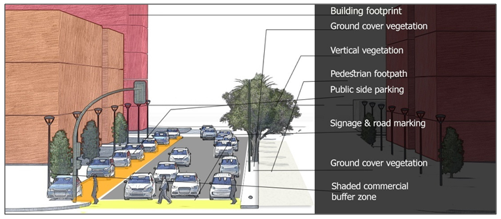
Figure 21. Perspective drawing demonstrating proposed strategies for MJ Street (Source: Author, 2017)

5. Conclusions and Discussion

This section summarizes the discussions, which have been generated mainly from the literature, site analysis, and data analysis, as well as proposed strategies for addressing the research problems. These decisions are layered, beginning with current issues and continuing to affect the role of government—always linked to the proposed methods of treatment of MJ-street.
The social characteristics of MJ Street have placed it in a complicated situation in which interactions between inhabitants and built forms occur at the lowest level, with limited consideration for the availability of ways of enhancing the street as well as inhabitants’ quality of living. Accordingly, the social sustainability of the street should be explored, enhanced, and raised with the aid of the main pillars of social sustainability: environment, economic, and social development. Such integrated strategies comport with the thrust of the Qatar National Vision (QNV) for 2030 by placing the responsibility for accomplishing this on governmental institutions.
Institutional bodies, following governmental agendas, should address changes in long-term alignment, carried out at all levels—both physical and institutional. In particular, a proper agenda will emphasize the role of the street in the state’s plans while also considering components of proper urban design and relevant environmental standards.
Because urban design seeks to develop functional and sustainable settlements according to measurements that go beyond merely contemporary issues, responsible design strategies for MJ Street should consider the characteristics of the street, including its commercial and residential activity, prioritizing the human scale and paying attention to pedestrian needs and behaviours. Such design standards should also consider the environmental aspects of enhancing residential activities and must include pathway design, city furniture, and green areas as elements increasing the quality of life for street inhabitants and visitors.
Informing the development and enhancement of the quality of the street and residences alike, data obtained through site analysis, observation, and in-depth interviews —both social and physical—highlight three systematic recommendations. First, considering the social pattern of commercial activity, the authors propose a method for reducing the influence of such activity on users. Second, they consider issues of accessibility and vehicular congestion in the street. Third, they consider environmental aspects such as vegetation and inhabitant health.

6. Contribution to Knowledge

Because issues of social sustainability and urban design have failed to attract suitable levels of attention from local scholars, gaps have arisen in the research. Accordingly, this paper investigates the relationship between social sustainability and urban design standards in the state of Qatar with an eye to translating theoretical knowledge into applicable principles of urban planning. In doing so, it will help close the gaps in knowledge related to Qatar and GCC countries.

7. Implications for Practice and Advancement of Research

This paper could be further expanded to urban planning, urban design, social development, and environmental engineering. Urban design and social development chiefly focus on the relationship between built and unbuilt forms with an eye to creating healthy, sustainable communities for current and future generations.

ACKNOWLEDGMENTS

Mahmoud H. Al Saeed has 5 years’ experience working as an architect and as a green building specialist, with 3 years served in the gulf region and 2 in Jordan. He has a LEED GA certificate, a CGP certificate, and an UPDA certificate for practice as an architect and has been a member of GORD (the Gulf Organization of Research and Development — QA1669 001858) since 2014. Dr. Raffaello Furlan holds Bachelors and Masters Degrees from IUAV University in Venice (Italy), and a PhD in Architecture from Griffith University in Brisbane (Australia). He has held visiting and permanent positions in Australia (University of Queensland and Griffith University in Brisbane), UAE (Canadian University of Dubai) and Qatar (Qatar University). He has been teaching Art History, History of Architecture, Project Management, Urban Design, Architecture Design and Interior Design. His areas of interest include Vernacular Architecture, Architecture and Urban Sociology, Project management, Art History. Member of the Board of Architects in Italy and Australia, he has 20 years professional experience, split between design management, project management and supervision roles, with some highly respected companies, 6 years of which were in Italy, 10 years in Australia, and 4 years in Middle East. He is an assistant professor in the Department of Architecture and Urban Planning (DAUP) at Qatar University.
This research study was developed as an assignment as part of the core course Research and Statistical Analysis in Planning (MUPD601, Spring 2017) taught by Dr. Raffaello Furlan at Qatar University, College of Engineering, Department of Architecture and Urban Planning (DAUP), for the Master’s in Urban Planning and Design (MUPD) program.
The authors would like to acknowledge the support of Qatar University in creating an environment that encourages scientific research. Also, they express their gratitude to the government of Qatar, namely to the Ministry of Municipality and Environment (MME), for providing relevant visual data and cardinal documents to aid the purpose of this research study. Finally, the authors thank the anonymous reviewers for their comments, which have improved the quality of this paper. The authors are solely responsible for the statements made herein.

References

[1]  Adhya, A., Plowright, P., & Stevens, J. (2014). Defining Sustainable Urbanism: towards a responsive urban design. Paper presented at the Conference On Technology & Sustainability in the Built Environment, King Saud University - College of Architecture and Planning.
[2]  AlSayyad, N. (1991). Cities and Caliphs: On the Genesis of Arab Muslim Urbanism. US: Greenwood Press.
[3]  Association, A. P. (2006). Planning and urban design standards: John Wiley & Sons.
[4]  Authority, Q. S. (2010). Establishments by status of establishment and zone. Qatar.
[5]  Barbosa, O., Tratalos, J. A., Armsworth, P. R., Davies, R. G., Fuller, R. A., Johnson, P., & Gaston, K. J. (2007). Who benefits from access to green space? A case study from Sheffield, UK. Landscape and Urban Planning, 83(2), 187-195.
[6]  Barton, H. (2000). sustainable communities, Earthscan, London.
[7]  Brown, L. J., & Dixon, D. (2014). Urban design for an urban century: Shaping more livable, equitable, and resilient cities: John Wiley & Sons.
[8]  Day, K. (2003). New urbanism and the challenges of designing for diversity. Journal of Planning Education and Research, 23(1), 83-95.
[9]  Department of Transport, T. a. S. (2013). Design Manual for Urban Roads & Streets (DMURS). Ireland: DOTT.
[10]  Donald Watson, A. P., and Robert Shibly. (2003). Time-saver standards for urban design. NY: McGraw-Hill.
[11]  Fahmy, M., & Sharples, S. (2009). On the development of an urban passive thermal comfort system in Cairo, Egypt. Building and Environment, 44(9), 1907-1916.
[12]  Farr, D. (2008). Sustainable Urbanism - Urban Design with Nature. USA: Wiley.
[13]  Fromherz, A. (2012). Qatar: A Modern History. Washington, DC: Georgetown University Press.
[14]  Furlan, R. (2015). Liveability and Social Capital in West Bay, the New Business Precinct of Doha. Arts and Social Sciences Journal’, 6(3), 1-11.
[15]  Furlan, R. (2016). Modern and Vernacular Settlements in Doha: An Urban Planning Strategy to Pursue Modernity and Consolidate Cultural identity. Arts and Social Sciences Journal, 7(2), 171-176.
[16]  Furlan, R., & Almohannadi, M. (2016). Light Rail Transit and Land Use: An Integrated Planning Strategy for Al-Qassar’s TOD in Qatar. International Journal of Architectural Research-ArchNet-IJAR’, 10(3), 170-192.
[17]  Furlan, R., & Faggion, L. (2017). Urban Regeneration of GCC Cities: Preserving the Urban Fabric’s Cultural Heritage and Social Complexity. Journal of Historical Archaeology & Anthropological Sciences, 1(1), 1-16.
[18]  Furlan, R., & Mogra, S. (2017). Public Realm at Qatar University Campus: Perception and sustainability of Open Green Spaces. Saudi Journal of Humanities and Social Sciences, 2(1), 80-94.
[19]  Furlan, R., Muneerudeen, A., & Khani, F. A. (2016). Urban Revitalization of Public Spaces in the Pearl in Qatar. American Journal of Sociological Research, 6(1), 1-9.
[20]  Furlan, R., N.Eiraibe, & AL-Malki, A. (2015). Exploration of Sustainable Urban Qualities of Al Saad Area in Doha. American Journal of Sociological Research, 5(4), 101-118.
[21]  Furlan, R., Nafi, S., & Alattar, D. (2015). Urban Built Form of the Souq Waqif in Doha and User’s Social Engagement. American Journal of Sociological Research, 5(3), 73-88.
[22]  Furlan, R., & Petruccioli, A. (2016). Affordable Housing for Middle Income Expats in Qatar: Strategies for Implementing Livability and Urban Form. International Journal of Architectural Research-ArchNet-IJAR’, 10(3), 138-151.
[23]  Furlan, R., Rajan, S. R., & AlNuaimi, A. (2016). Qatar University Campus : Built Form , Culture and Livability. 6(4), 99-112. doi: 10.5923/j.sociology.20160604.02.
[24]  Furlan, R., & Sipe, N. (2017). Light Rail Transit (LRT) and Transit Villages in Qatar: A Planning-Strategy to Revitalize the Built Environment of Doha. Journal of Urban Regeneration and Renewal, 10(4), 1-20.
[25]  Furlan, R., & Wadi, R. (2017). The Quality of Urban Life (QOUL) of New-Salata Neighborhood in Qatar. American Journal of Sociological Research, 7(1).
[26]  Furlan, R., Zaina, S., & Zaina, S. (2016). Urban Planning in Qatar: Strategies and Vision for the Development of Transit Villages in Doha. Australian Planner, 53(4), 286-301.
[27]  Givoni, B. (1998). Climate considerations in building and urban design: John Wiley & Sons.
[28]  GORD. (2015). Training manual 1,2. QATAR: GORD.
[29]  Gulyás, Á., Unger, J., & Matzarakis, A. (2006). Assessment of the microclimatic and human comfort conditions in a complex urban environment: modelling and measurements. Building and Environment, 41(12), 1713-1722.
[30]  Hakim, B. S. (2014). Mediterranean Urbanism - Historic Urban/Building Rules and Processes. New York: Springer.
[31]  Jaidah, I., & Bourennane, M. (2010). The History of Qatari Architecture 1800-1950. Italy: Skira.
[32]  Jodidio, P., & Halbe, R. (2015). The New Architecture of Qatar. New York: Skira Rizzoli.
[33]  Kearns, A., & Turok, I. (2003). Sustainable communities: Dimensions and challenges: Department of Urban Studies, University of Glasgow.
[34]  Landry, C. (2006). The art of city-making: Routledge.
[35]  Littig, B., & Grießler, E. (2005). Social sustainability: a catchword between political pragmatism and social theory. International journal of sustainable development, 8(1-2), 65-79.
[36]  Lynch, K. (1960). The image of the city (Vol. 11): MIT press.
[37]  Manzi, T., Lucas, K., Jones, T. L., & Allen, J. (2010). Social sustainability in urban areas: Communities, connectivity and the urban fabric: Routledge.
[38]  Marg, K. K. (2012). IRC. New Delhi IRC.
[39]  Meadowcroft, J. (1999). The politics of sustainable development: emergent arenas and challenges for political science. International Political Science Review, 20(2), 219-237.
[40]  Moughtin, C., Oc, T., & Tiesdell, S. (1999). Urban design: ornament and decoration: Routledge.
[41]  NACTO. (2016). Urban Street Design Guide Retrieved 2017.03.01, from http://nacto.org/.
[42]  Oke, T. (2006). Instruments and observing methods: Report No. 81: initial guidance to obtain representative meteorological observations at urban sites. World Meteorological Organization, WMO/TD (1250).
[43]  Oke, T. R., Crowther, J., McNaughton, K., Monteith, J., & Gardiner, B. (1989). The micrometeorology of the urban forest [and discussion]. Philosophical Transactions of the Royal Society B: Biological Sciences, 324(1223), 335-349.
[44]  Qatar, G. (2008). Qatar National Vision 2030. Doha, General Secretariat for Development.
[45]  Ramadan, M. F. A. (2010). Interactive urban form design of local climate scale in hot semi-arid zone. The University of Sheffield.
[46]  Salama, A., & Wiedmann, F. (2013). Demystifying Doha. On Architecture and Urbanism in an Emerging City. Surrey: Ashgate Publishing Limited.
[47]  statistics, M. o. d. p. a. (2015). POPULATION AND SOCIAL STATISTICS. Qatar.
[48]  Stevenson, D. (2013). The City. UK: Polity.
[49]  Taha, H. (1997). Urban climates and heat islands: albedo, evapotranspiration, and anthropogenic heat. Energy and buildings, 25(2), 99-103.
[50]  United Nations, W. U. P. (2016). Urban population (% of total). The World Bank.
[51]  Retrieved from Van Assche, K., Beunen, R., Duineveld, M., & de Jong, H. (2013). Co-evolutions of planning and design: Risks and benefits of design perspectives in planning systems. Planning Theory, 12(2), 177-198.
[52]  Wiedmann, F., Salama, A., & Mirincheva, V. (2014). Sustainable urban qualities in the emerging city of Doha. Journal of Urbanism, 1-23.