-
Paper Information
- Paper Submission
-
Journal Information
- About This Journal
- Editorial Board
- Current Issue
- Archive
- Author Guidelines
- Contact Us
Architecture Research
p-ISSN: 2168-507X e-ISSN: 2168-5088
2017; 7(1): 24-28
doi:10.5923/j.arch.20170701.03

Uncontrolled Urban Expansion of Amman City and the Disintegration of the Rainfed Lands
 Abstract
 Reference
 Full-Text PDF
 Full-text HTML
Numan Abu Hammad
Department of Civil Engineering, Faculty of Engineering Technology, Al-Balqa' Applied University, Amman, Jordan
Correspondence to: Numan Abu Hammad, Department of Civil Engineering, Faculty of Engineering Technology, Al-Balqa' Applied University, Amman, Jordan.
| Email: |  |
Copyright © 2017 Scientific & Academic Publishing. All Rights Reserved.
This work is licensed under the Creative Commons Attribution International License (CC BY).
http://creativecommons.org/licenses/by/4.0/

Jordan is one of the arid and semi-arid regions with about 10 million inhabitations in the year 2016. Rainfed land which represents a major source of crops and vegetable, is facing a critical reduction due to the unexpected increase in the population, unexpected urban expansion and economic growth. The issue of rainfed lands exploitation in the Middle East and North Africa (MENA) region and particularly in Jordan is of prime importance for the development of the region in the future, considering the political instability in the region. In this article, the current problems are reviewed and research efforts is conducted to describe and to tackle this issue.
Keywords: Rainfed land, Land use, Water Scarcity, Urban development, Urban agriculture, Jordan
Cite this paper: Numan Abu Hammad, Uncontrolled Urban Expansion of Amman City and the Disintegration of the Rainfed Lands, Architecture Research, Vol. 7 No. 1, 2017, pp. 24-28. doi: 10.5923/j.arch.20170701.03.
1. Introduction
- The scarcity of freshwater in Jordan and the continuous increase in demand plays a major role in the development of Jordan. The water resources in Jordan consist of groundwater and fossil water which extends in aquifers at different depths through the country. The groundwater in Jordan represents the major source of drinking water. The water resources in Jordan mainly depend on rainfall, which is subjected to great variability. Meanwhile, there is an observed population growth, so there is high demand for water [1, 2]. Jordan is marked by sharp seasonal variation in both temperature and precipitation [3, 4]. Jordan is one of the arid and semi-arid regions where 90% of the country receives less than 200 mm of annual rainfall (Figure 1). The Area of Jordan is about 90,000 km2, were the agricultural land represent about 10% of the total land area. Twelve percent of this area have been over taken by urban expansion over the last few years. Whereas, 13% represents forest and woody areas, leaving only 63% for actual plantation. However due to the sever scarcity of water and limited annual rainfall quantity, only half of this land is used for agricultural activities. Only 5% of the total area is used for planting cereal and other crops, fructiferous and variable vegetables, covering 9%, 26% and 32% respectively. Whereas, 33% are bare lands not used for any other agricultural activities. Such areas are subjected to various climate conditions and misuse of civilians and habitants through dumping waste materials effecting the quality of soil and groundwater and surface water. The area is of major concern to the World Bank in terms of enhancing sustainable development in all regions [5].
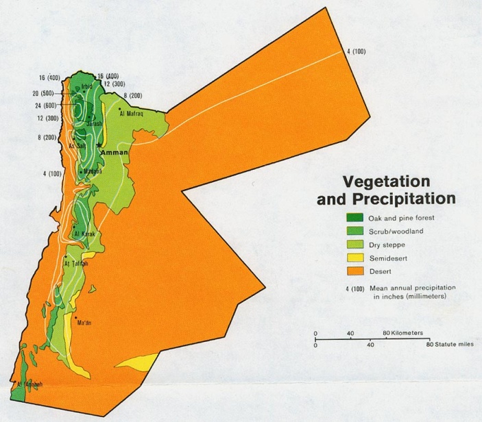 | Figure 1. A Vegetation and annual rainfall in Jordan [6] |
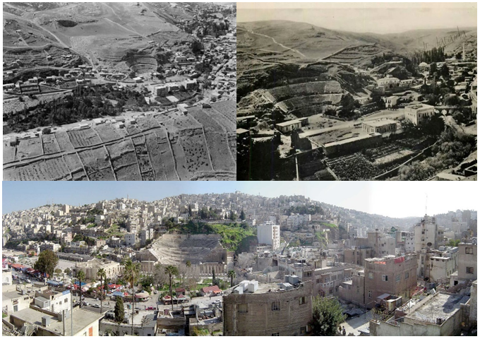 | Figure 2. Land use drastic change: Amman between the present and the past |
2. Discussion
- Any successful regional planning should take into account both urban development as well as maintaining the agricultural lands including forests, woods and natural reserves. Such balanced control and limitations on the light of the limited water resources will be an extra asset for the overall sustainable development. However, the concept of urban agriculture arose in the last few years creating a wide scope of production for self consumption and maintaining agricultural lands side by side with the urban development [7, 8]. The term rainfed agriculture is used to describe farming practises that rely on rainfall for water. It provides much of the food consumed by poor communities in developing countries. For example, rainfed agriculture accounts for more than 95% of farmed land in sub-Saharan Africa, 90% in Latin America, 75% in the Middle East and North Africa; 65% in East Asia and 60% in South Asia.Middle East and North Africa (MENA) region with Land area about 15.5 million Km2, is considered to be the most water scarce region in the world, with the highest levels of water deficit (Fig. 3). Desert land prevails over 85% of the region land area with annual rainfall is less than 25 cm. MENA hosts about 5% of world population with only 1% of the world’s renewable water resources. The MENA region falls far below the global average of 8000 m3 per year).
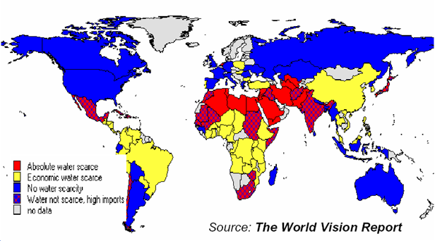 | Figure 3. Absolute Water Scarcity by 2025 [9] |
|
3. Conclusions and Remarks
- Water scarcity is the most important natural constraint to Jordan’s economic growth and development. Unprecedented demands on water resources with the rapid increases in population and the accelerated industrial development make the total annual demand approaching one billion cubic meters which approximately represents the limit of Jordan’s renewable and economically developable water resources. In order to highlight the severity of changing the agricultural land use, it is worth mentioning that the overall urban spaces in Amman and around areas is about 837 km² theoretically enough to accommodate 16 million inhabitants. At present these areas accommodate 3.3 million inhabitants and expected to touch 4.5 million by 2020. In addition, the land use and reuse is highly effected by several legal references (more than seven) controverting each other in terms of responsibilities and legal authority creating a huge gap in establishing integrated cooperation between different entities [12].In the last two decades, the urban planning consumed large area of lands traditionally used for rain fed (non-irrigated) cultivation. This pattern created more stress in the limited water resources and reduced the quantity of vegetables, fruits sessional crops and cereal available for local people. The farmer became more dependent on the underground water resources in the light of low rainfall rates and drastic climate change.Observing Jordan natural map showing land use (Figure 4) and annual rainfall distribution (Figure 1), it is advised to shift the urban planning expansion to the east and south east of the kingdom (Fig. 3). Three main factors should be considered in order to control the urban, population expansion such as refugees’ camps and selection of utilities location, such as waste landfills and wastewater treatment plants. These factors should include detailed investigation on the soil type, topography and amount of the annual rain fall. This probably will limit the miss use of lands using non-irrigated techniques which again, will substitute otherirrigated lands with extra water. Such rainfed land may be considered as controlled conservation land by law.
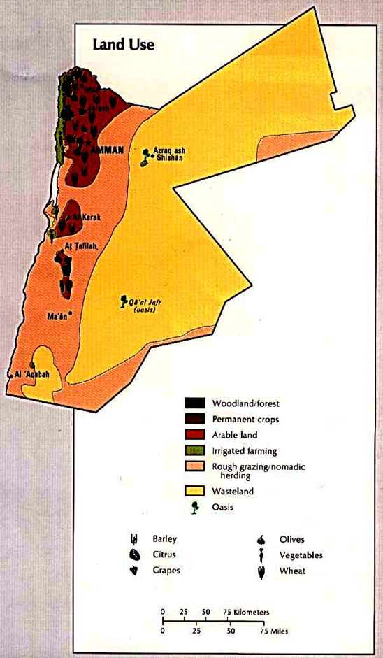 | Figure 4. Land Use in Jordan, [13] |