-
Paper Information
- Next Paper
- Paper Submission
-
Journal Information
- About This Journal
- Editorial Board
- Current Issue
- Archive
- Author Guidelines
- Contact Us
Architecture Research
p-ISSN: 2168-507X e-ISSN: 2168-5088
2016; 6(5): 116-122
doi:10.5923/j.arch.20160605.02

Development and Trends of Urban Growth in Mafraq City, Jordan
 Abstract
 Reference
 Full-Text PDF
 Full-text HTML
Saqer Mustafa Sqour1, Abdelmajeed Rjoub2, Mohannad Tarrad2
1Architecture Department-Engineering College- Al al-Bayt University, Mafraq, Jordan, Director of Architecture and Interior Architecture, COEA, Al Yamamah University, Riyadh, Saudi Arabia
2Architecture Department-Engineering College- Al al-Bayt University, Mafraq, Jordan
Correspondence to: Saqer Mustafa Sqour, Architecture Department-Engineering College- Al al-Bayt University, Mafraq, Jordan, Director of Architecture and Interior Architecture, COEA, Al Yamamah University, Riyadh, Saudi Arabia.
| Email: |  |
Copyright © 2016 Scientific & Academic Publishing. All Rights Reserved.
This work is licensed under the Creative Commons Attribution International License (CC BY).
http://creativecommons.org/licenses/by/4.0/

Mafraq is the administrative centre of Mafraq Governorate, which witnessed rapid urban growth, represented by population and area expansion. This growth occurred without the use of strategies or tactics to decide its directions of growth. Although Mafraq has had certain improvements in its urban environment, it suffers from traffic jams caused by increased pressure on city services. This pressure has risen because of the Syrian crises in the last two years. This research found the climate, the nature of city, and the axes to main roads contributed for expanding the city in certain directions, while military camps and the military airport blocked the city’s growth in other directions. Besides, there are other reasons that led to growth of the city like founding the railway station, starting Al al-Bayt University, the presence of the military camps, and settling Al-Za'atari Syrian refugee camp. However, these poles played a significant role in shaping the city. This research studies the city comprehensively, identifies forces behind its urban expansion, and examines the effects of this expansion on forming the city. Such a study will help to identify the future directions for expansion. Finally, the study suggests several plans for developing the city; among these proposals to move army camps from the city, since these camps block the growth of the city towards the area of the King Hussein Economic Zone. This change will allow housing projects and development to benefit the city and its residents, which can reduce the pressure on agricultural land in western and southern areas of the city.
Keywords: Urban planning, Urbanization, Urban growth, Mafraq
Cite this paper: Saqer Mustafa Sqour, Abdelmajeed Rjoub, Mohannad Tarrad, Development and Trends of Urban Growth in Mafraq City, Jordan, Architecture Research, Vol. 6 No. 5, 2016, pp. 116-122. doi: 10.5923/j.arch.20160605.02.
Article Outline
1. Introduction
- Mafraq is in the northern region of Jordan; it has experienced a rapid growth in population and a quick expansion in size. However, the conditions around Mafraq result in several economic and social problems. These problems, with a lack of proper urban planning, result in traffic jams, create unplanned centers for the city, and produce intense pressure on services and the environment. In the long run, this results in low public service delivery, weakness in the networks, and increase in desertification, as well as other problems. Therefore, there is a need for a studying conditions of the city, stages of its development, and trends in architectural growth.
2. Importance of the Study
- The importance of the study comes from the importance of Mafraq itself, historically and geographically. The city witnessed a rapid increase in population as the administrative center of Al-Mafraq Governorate. This study is one of the pioneer studies that dealt with urban planning and growth in Mafraq in Jordan. It is hoped that the proposals of this study will help authorities and decision-makers to organize and manage the city and address various problems.
3. Research Objectives
- The study examines the causes that influenced the growth of the city of Mafraq, and the reasons for the increase in the number of inhabitants, with the aim of achieving the following objectives:• To note the importance of the city and study the general characteristics of the site and weather.• To note themes and trends in urban growth of the city and what influenced this growth. And, to study the influence of expansion on the overall shape of the city and on dividing public services.• To identify stages of growth and events and their impact on the city, from its beginning until now (1900 until 2010).• To examine future trends for expansion within current conditions of the city based on the results of the study.
4. Methodology
- This research followed two complete methods in studying the problems of the city and ways to solve them:• Inductive approach (formative), which focused on studying the geography of the city and analyzing urban life, and• Quantitative approach, which looks at the general case of the city and moves toward the specific. It is originally developed in natural sciences to study natural phenomena.
5. Previous Studies
- There have been few studies on Mafraq in the literature and even fewer on urban planning in Mafraq. However, there have been studies about other cities of Jordan and several of them can help this study:• Suleiman Abu Kharma’s (2005) study about urban growth in Irbid;• Othman Ghoneim’s (2001) study about Salt City, which aims to show the effect of topography in shaping the city’s urban development patterns;• Samer Takruri’s (2000) study, which processes the land-use map of Mafraq city using geographic information systems;• Abdelqader Al-Husan’s (1999) study on archaeological and surveying studies in Mafraq;• Salah Kazan’s (2007) study on Mafraq and the neighboring area.
6. The Characteristics of the Study Area
6.1. Geographical Location and Administrative Boundaries
- Mafraq lies in the west of Mafraq Governorate. It is at the intersection of longitude 36.1 degrees east and latitude 32.2 degrees north. The distance from Mafraq to Amman is around 65 kilometers. Its location borders three Arab countries: Syria to the north, Iraq to the east, and Saudi Arabia to the south. The city has a direct link with the governorates of Irbid, Jerash, and Zarqa by main roads. The municipality consists of the following major districts: Mafraq district, Idunn Beni Hassan district, Eastern Um Al-Na'am district, Hayyan ALmisharef district, Eastern Alboaidah district, and Thugrate Al-jub district (Jordanian Legislations, 2000).
6.2. Area
- The estimated area of Mafraq at the end of the 1960s was about 4.5 square kilometers; it reached five square kilometers at the end of the seventies, and it was around seven square kilometers in 1992. The total area of Mafraq and its districts (Greater Mafraq) recently reached one hundred square kilometres, about fourty square kilometres of which is organized area. The area of Mafraq city is twenty six square kilometres, of which only eleven square kilometres are organized (Municipality of Mafraq, 2009).
6.3. Population
- Since 1952, the population of the city has increased significantly. The population was then six thousand (Department of Statistics, 1952). In 1961, the population was nine thousand five hundred, and then exceeded twenty one thousand people in 1979, almost doubling; in 1994, it rose to thirty two thousand.In 2009, authorities estimated people of Greater Mafraq to be around fifty eight thousand (Department of Statistics, 1952). The density of the population was 2.26 person/ square kilometre, (Ministry of Municipalities, 2009).
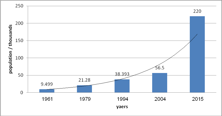 | Figure 1. Population growth in Mafraq between 1961-2015 |
7. Natural Conditions of the City
7.1. Climate
- The climate in Mafraq is classified as semi-desert, which is distinguished by hot, dry weather in summer and cold weather in winter. The city is characterized by the presence of two main seasons: summer, which begins in mid-May and ends in September, and winter, which begins in November and ends by the end of April. Spring does not extend beyond April and May, while autumn is limited to September and October.The highest monthly average temperature is in August and reaches 32.6°C; the lowest monthly average temperature is 2°C in January, with an annual average temperature of 18°C (Department of Meteorology, 2014). In addition, the city has an average relative humidity of 36%. The city has the lowest annual rainfall average in the country, which does not exceed 150 millimetres a year.
7.2. Topography
- The topography of the city is mostly flat, with simple ups and downs. The elevation ranges from 675 meters to 750 meters above sea level.
7.3. Water Resources
- The region is characterized by dryness. It lacks surface water sources, except in the rare case of floods that result from the rainwater in the winter seasons. The main source of water for the city is groundwater extracted from artesian wells around the city (Salameh, 1997) (1).
7.4. Soil and Vegetation
- The soil in the city is classified as saline and alkaline and appears in the form of weakly spiked hills. The soil in the eastern areas of the city is weak. It consists of grasses, weeds, and trees, which rely on irrigation, while the western soil is more fertile and more suitable for grazing and cultivation of winter crops and forest trees. It also relies on rainwater and irrigation (Harahasheh, 2005).
8. Stages of Growth and Expansion of the City
8.1. Antiquity
- The beginnings of Al Mafraq city date back to the second Iron Age (about 900 BC). The evidence is found in the cultural and historical buildups found in the downtown area, in the archaeological site named Alfdain, which contains the traces and remains of stone buildings. Some of these buildings are believed to be defensive castles to protect the Kings Road (Al-Hisan, 1999). Further, there are calcareous Nabataean, Greek, and Thamudic stones containing inscriptions that give emphasis to the Trajanos Road from the same location (Al-Hisan, 1999).In the period of Islamic rule, this site was cared for and reused, especially in the early Umayyad period (661 AD -750 AD). Then, buildings were restored and maintained, and more buildings were added to form a palace with a mosque (Al-Hisan, 1994).
8.2. The Ottoman Empire
- The site of Al Mafraq had a special meaning in the Ottoman Empire, when the location was a major stop on the Hejaz railway. The Ottomans then built Mafraq Station in 1903.
8.3. Modernity: (1923-1945 A.D.)
- The modern stage is the beginning of the emergence of the Jordanian State (Emirate of Eastern Jordan) in 1923. During this stage, some events influenced the city, such as:• The arrival of immigrants from Morocco. They arrived and stayed in Mafraq.• The discovery of oil in Iraq and the Gulf. The Iraq Petroleum Company and the Trans Arabian Pipeline Company settled Baghdad's Haifa line in 1935. They chose the city to be the site of the main station on those lines, built the headquarters of those companies in the city, and formed a point from which to collect workers.• The presence of British troops in the region during the Second World War and establishing military camps and the airport make Mafraq an important center in the eastern parts of Jordan.
8.4. The Period (1945-1948 A.D)
- In this period, the government decided to upgrade Mafraq from a village to a town. It established Mafraq Municipality in 1944; and, in 1947 the city was declared as a centre of Mafraq Government.During this period, conflicts existed between the Arabs and Israel, and wars erupted from 1948 till 1967, which is why many Palestinians migrated to Jordan.
8.5. The Period (1970-1990 A.D.)
- During this time, Mafraq was promoted to one of the twelve administrative governorates in Jordan in 1985 (Jordanian legislation, 1985).
8.6. The Period (2000 A.D. to Present)
- During this period, the city witnessed the following events:• The establishment of Mafraq Greater Municipality in 2002 (Jordanian Legislation, 1985).• Building various factories with heavy and light industries in southern and southeastern parts of the city, and finding out the Economic Region of King Al-Hussein in the northeast of the city (Social Security Corporation Website, 2014).
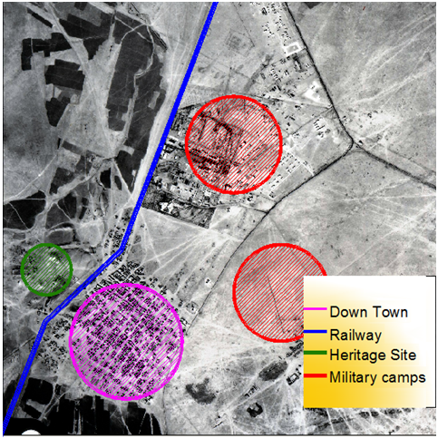 | Figure 2. Aerial photograph of AI Mafraq in 1953 shows urban extension trends (Source: Royal Geographic Center) |
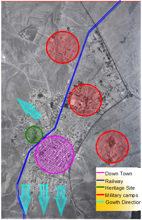 | Figure 3. Aerial photograph of AI Mafraq in 1978 shows urban extension trends (Source: Royal Geographic Center) |
9. Causes of Growth and Expansion Trends
9.1. Climate and Natural Conditions
- Climate and moderate natural conditions contributed to create a residential environment in the city: flat surfaces, high-quality soil, and moderate climate, especially in the southern and western regions.
9.2. Transport and the Al- Hijaz Railway
- The roads coming out of Mafraq toward the major bordering cities (Irbid, Jerash and Zarqa) had a significant effect on the growth and extension of the city and appearance of the residential neighborhood.
9.3. Camps and Land Belonging to the State Treasury
- Existence of the camps and the military airport on the north and northeast edges played a major role in expanding the city in these directions.
9.4. Al al-Bayt University
- Establishing the University of AL al-Bayt in (1994) in the eastern region had a significant impact on the growth of the city. The university attracted large numbers of students and staff to live in the city, which revived its economical and social status. However, influence remains limited, because of the presence of barriers separating the university, such as the military camps. This remained the case until a new gate for the university from the south was constructed in 2004, resulting in housing projects and commercial markets. Further, in 2008, a direct road was opened between the west side of the university and the city.
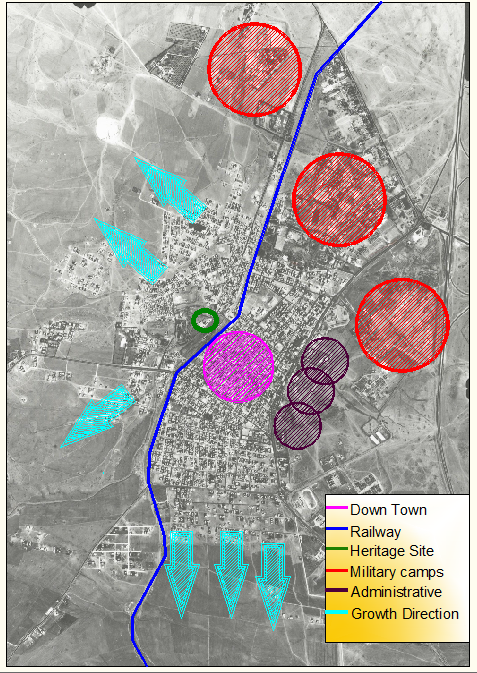 | Figure 4. Aerial photograph of AI Mafraq in 1992 shows urban extension trends (Source: Royal Geographic Center) |
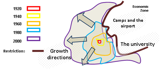 | Figure 5. Shows the city and expansion by the year |
10. The Influence of Al-Za'atari Camp on Urban Expansion
- Al-Za'atari camp is in the east of Mafraq. The Jordanian government found out the camp housed Syrian refugees who came to Jordan in 2011. Despite the inconsistent number of population of Al-Za'atari camp, its population is larger than the city of Mafraq itself. This fact increases the importance of studying this population crowding the city's urban expansion.
11. Analysis of the General Plan for the City
- By analyzing the plan of the city and identifying the stages of urban development, the authors found the city has two styles of urban growth:• Regular growth is when streets have a geometric shape (grid orthogonal). This style is reflected clearly in the central parts bounded by the railway line and Al-Jaysh (Military) Street. Thus, these areas are characterized by the ease of controlling ownership, ease of transport, frequent dangerous traffic intersections, and a severe overlap in land uses in its urban fabric.• The irregular style of urban growth results in zigzag streets and irregular tracts of land, due to lack of organizational schemes and the nature of the land in those areas.Thus, the overall shape of the city forms a half circle. This shape came to exist due to the urban expansion around the center of the city westward. However, this creates a ring road around the city, which activates the traffic between parts of the city and reduces pressure on roads passing its center.
12. Distribution of Land Use
- Different causes and circumstances divided land use in the city. Overall, land use is divided as follows:• Domestic use forms the greatest part of land use, which is divided into areas A, B, and C, with 80% of the total organizational areas distributed in 25 residential neighborhoods.• The business district covers 5% of the land area and is concentrated in the central area of the city.• Industrial uses covers 2% of the land area. This craftsmanship centered city contains metalwork and carpentry workshops in the west, mechanics workshops and automobiles' services in the south-east, and light industries in the southern region. Further, green areas are almost nonexistent in the city; they only cover about two acres of the total.
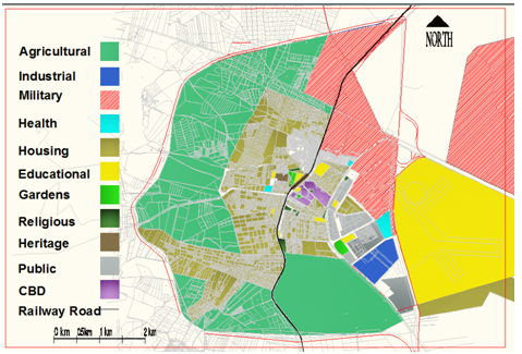 | Figure 6. Land use plan for the city of Mafraq in general |
13. Theoretical Future Trends of Expansion
- There are various theories that have tried to find a correlation between the city and its regions to adjust for future growth and thus link it with underlying regions, depending on different circumstances (Hammad, 1995).After studying the reasons effecting the formation of Mafraq, reality of the city, land use and growth of the city, the researcher expects the best applicable theories on Mafraq to be as follows:
13.1. Growth Pole
- This theory focuses on the center of the city as a pole, which plays a dominant role in deciding directions of urban growth. Further, every growth pole can bring changes in various other areas around it.The idea of the growth poles theory is that economic growth is not equal over entire region, but it happens encircling a specific pole. This pole is frequently characterized by a core around which different areas develop.Growth cores or poles can be among wide range of sectors such as universities, airports, railway stations, transport terminals, industrial zones, moles, factories, etc. These cores have direct and indirect effect on urban growth. Nevertheless, to expand the core means the increase of transport, employment, investments and technologies. Besides, transport plays a major role in such a process, the better arranged transport, the stronger relationship between different cores. This, later, will result in the emergence of secondary growth poles.
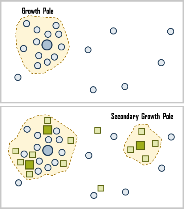 | Figure 7. Shows how the main and the secondary growth poles lead growth direction of cities |
13.2. Center and Periphery
- This theory tries to explain the variation in regional development, where the growth does not occur in all areas at the same time but appears in the form of growth poles.Under the current conditions, it appears the principal axis of urban expansion faces west and south. Expansion towards the east and north is not possible because of military camps. Nevertheless, there is a lack of agricultural land in the western regions, as well as the high cost of providing various services to people, since there is a long-distance to the city center.
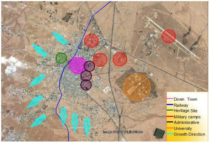 | Figure 8. An aerial view in 2014 shows urban growth poles and future expected extension of Mafraq |
14. Conclusions
- To suggest solutions for the unplanned growth of cities needs understanding of their expansion through outskirts. Because, the uncontrolled urban growth is a significant crisis not only for Mafraq but also for other cities of Jordan.Besides, the researchers could reach that different reasons led to the growth of the city and made it a magnet for residents:Location of Mafraq, its importance, and establishment of the railway station made the city an administrative and commercial center of Mafraq Governorate.Ÿ The roads that come out of the city formed a linear development for the city, thus introducing a longitudinal extension of the city that led to unplanned distribution for services among the new neighborhoods. In the long run, this will reduce agricultural land in different areas.Ÿ Nature and climate affected spread of urbanization in all directions of the city except the eastern side, because of the presence of military camps and the government’s ownership of land.Ÿ The city center suffers from irregular commercial performance and high traffic density. Besides, other organizational problems, such as bad enforcement of buildings' laws and the spread of ugly facades of buildings.Ÿ The Al-Za'atari camp, which borders the city of Mafraq, as well as the military areas, came to form other poles to decide the urban growth of the city. Thus, they play a significant role in shaping the city and surroundings.Ÿ The researchers believe the two theories of urban growth: the theories of growth pole and center and periphery are applicable to Mafraq city, since, social and built environment of the city agree with these theories.Ÿ The future research studies are expected to be about city expansion for different cities in Jordan.
15. Recommendations
- Ÿ It is essential to understand the growth of the city and to put plans for proper urban planning. It is also necessary to activate building laws, to reduce infringement, and to consider environmental preservation. This task is the responsibility of Mafraq Greater Authorities, since the city is in stages of demographic growth, before increasing problems occur, which are difficult to deal with in the future.Ÿ There exists an urgent need to send the military camps away to exploit their lands for housing and development projects, since the camps have become closer to neighborhoods of city. Further, shifting the camps out will direct the urban expansion towards the area of development in the north, thus reducing pressure on the city center. Further, there is a need to spread services among recent neighborhoods to reduce population pressure and traffic in the city center.Ÿ It remains necessary to impose a plan for the city, by moving the industrial zone to the southeast side of the city and forcing scattered workshops in various parts of the city to shift to the areas planned for them.Ÿ Consideration should be ensured in developing both the historic site (Al-fdain) and the railway station buildings, for their obvious importance in confirming the identity of the city. Further, there should be a notable increase in the parks and green areas of the city.
Note
- 1. There are 440 artesian wells in Mafraq Governorate, which produce 75% of the water in the Kingdom (Publications of the Ministry of Agriculture in 2009).