-
Paper Information
- Next Paper
- Paper Submission
-
Journal Information
- About This Journal
- Editorial Board
- Current Issue
- Archive
- Author Guidelines
- Contact Us
Architecture Research
p-ISSN: 2168-507X e-ISSN: 2168-5088
2012; 2(6): 115-121
doi: 10.5923/j.arch.20120206.01
Urban Flood Management – A Case Study of Chennai City
 Abstract
 Reference
 Full-Text PDF
 Full-Text HTML
Ar. K. Lavanya
Crescent School of Architecture, B.S.Abdur Rahman University, Chennai, 600073, India
Correspondence to: Ar. K. Lavanya, Crescent School of Architecture, B.S.Abdur Rahman University, Chennai, 600073, India.
| Email: |  |
Copyright © 2012 Scientific & Academic Publishing. All Rights Reserved.
In the recent decades, Indian cities are witnessing devastating floods more often due to heavy rainfall, cyclones, etc., Though Tamil Nadu is not under flood risk prone zone as mapped by meteorological department (New Delhi), within the local body there are few low-lying areas which are susceptible to inundation which also depends mainly on the developments near major drainage systems, encroachment of water bodies, inability of major canals to carry heavy rains, overflowing reservoirs. Chennai, one of the fast growing metros is likely affected by the lack of drainage mainly due to uncontrolled developments of concrete spaces, encroachment of major drainage channels, shrinking of marshlands, etc,. Though Urbanization, the vital factor of response for the flood risks is coupled with the climatic variability and ecological imbalances. The paper discusses causative factors responsible for flood risks in Chennai, the immediate need for proper flood risk reduction and management strategies.
Keywords: Urban Flood, Flood Management, Flood Risk, Chennai Flood
Cite this paper: Ar. K. Lavanya, "Urban Flood Management – A Case Study of Chennai City", Architecture Research, Vol. 2 No. 6, 2012, pp. 115-121. doi: 10.5923/j.arch.20120206.01.
Article Outline
1. Prologue of Chennai
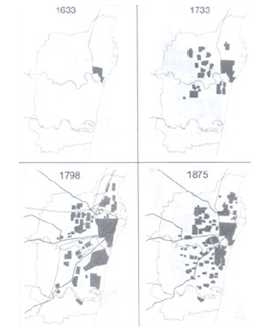
- Chennai, State capital of Tamil Nadu lies in the Eastern Coast of South India where three watercourses meanders through it namely, Cooum River, Adyar River and Buckingham Canal. Chennai is the fourth largest Metropolitan in India having a total population of nearly 47 Lakhs1 with a growth rate of 13% and density of 26903. Within a century, Chennai has grown 8 fold times in population (Figure 1).
1.1. Growth of Chennai City
- Chennai, having a plain terrain is bounded by Bay of Bengal in the East with an average elevation 6.7m from the mean sea level. Chennai experiences most of its rainfall during October to December associated with Depressions & frequent cyclones during this period. Average annual rainfall is about 1200 mm – 1300 mm being situated on the coastal side.
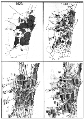 | Figure 1. Growth of Chennai City (Source: Chennai Municipal Area Corporation) |
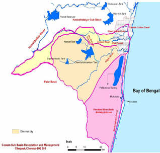 | Figure 2. Rivers & Drainage Systems of CMA (Source: An Article on “Waterways in Chennai” by T. Kanthimathinathan) |
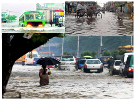
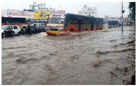
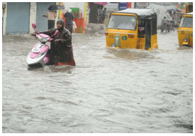
2. History of Chennai Floods
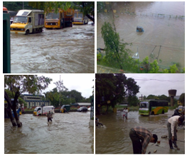
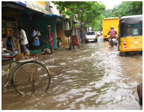
- Chennai frequently experiences flooding due to heavy rain associated with depressions & cyclones. Of which few catastrophic floods during 1976, 1985, 1996, 1998, 2005, 2008 and 2010 caused heavy damages. Now-a-days, unexpected holidays due to heavy downpour are quite common especially during October – December. In short, Chennai is not starving for rain; it is starving for water which is due to mismanagement of water storage. In 2010, Chennai received about 760mm rainfall only during October – December period. Recent highest rainfall in a day was 423 mm on 27.10.2005. All these shows whether Chennai is prepared to drain this flash flood without having hindrances in their day – today life? Closing of schools due to flooding every year is common in many parts of Chennai. Since it is more frequent every year why effective management is not so happened? Where is the lacuna? This article is aimed to arrive out the gaps in resolving the persistent issue. Though the paper is majorly based on data from secondary sources, the data analysis & inferences out of that is purely arrived on the basis of current happenings.
2.1. Causes of Chennai Floods (Table 1)
- The following are the factors[1] which hamper the living in Chennai due to floods though it can be categorized broadly under changes in climate & micro-regional environmental factors. Each factor (Table 1) is dealt in detail in the subsequent clauses.
2.2. Direct Factors
2.2.1. Increase in Rainfall
- Chennai accounts to frequent flash floods due to consistent increase in the amount of rainfall also, out of which during 2005, 2008 & 2010 are considerable one (Figure 3). The city gets most of its seasonal rainfall from the north–east monsoon winds during mid of October to mid of December. Cyclones in the Bay of Bengal also sometimes hit the city.
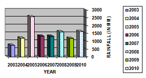 | Figure 3. Average annual rainfall in Chennai(Source: Chennai Meteorological Department) |
2.2.2. Urbanization
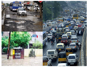
 Chennai with the fast pace of developments has witnessed a steady deterioration and decrease in the number of water bodies. It is estimated that more than half of the wetlands have been converted for other uses. Chennai had about 6502 small and big water bodies in and around the city, but today the number has been reduced to less than 30. Ownership of water bodies is scattered among various government departments and is the root cause for lack of proper management. The Protection of Tanks and Eviction of Encroachment Act, came into effect from October 2007. However, there has been lack of implementation of this law.This 65-year old map (Figure 4) shows the locations of several water bodies. The gray areas of the map represent eris, or small ponds. The gray water bodies are seasonal, in that they appear during the rainy seasons and remain dry during the rest of the year. When this map is compared with the recent one, it shows many of the water bodies have either shrunk or disappeared. According to records of the Water Resources Department (WRD), the area of 19 major lakes has been shrunk from a total of 1,130 hectares to nearly 645 hectares and hence reduced their storage capacity. Also, the ground water level came down up to 10m within 5 years (1995 – 2001)[6].The drastic change in Land Use of Chennai[6] due to urbanization (1995 – 2007) also adds fuel to the current risk of flood in every year. The change in land cover during 1997 to 2001 is given in Figure 5. Most of the green cover are reduced to non-vegetative or a concrete space. Due to this, the surface run-off is too high and the infiltration capacity of land has gone down drastically. Due to the increase in impervious areas, Chennai experiences severity of floods during every heavy rainfall.
 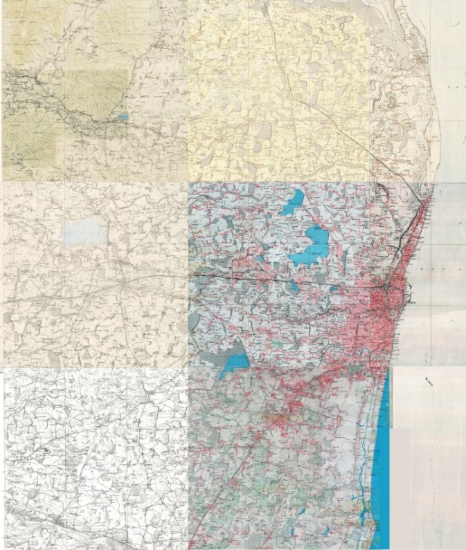 | Figure 4. Map showing the locations of various water bodies located in and around Chennai before 65 years |
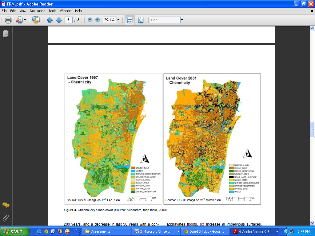 | Figure 5. Chennai – City’s Land Cover during 1997 & 2001 (Source: Sundaram Map, 2009) |
2.2.3. Topography
- Chennai has a terrain slope varying from 1:5000 to 1: 10000. It is a low-lying area and almost like a pancake. It rises slightly as the distance from the sea-shore increases but the average elevation of the city is not more than 22' above MSL, while most of the localities are just at sea-level and drainage in such areas remains a serious problem.
 | Figure 6. Flood risk hotspots in Chennai Metropolitan area (Source: CMDA) |
2.3. Indirect Factors
2.3.1. Inadequate and Poor Drainage Systems
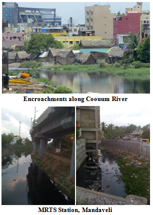
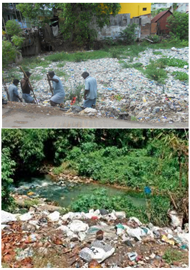
- Apart from plain terrain lacking natural gradient for free run-off, the sewage system was originally designed for about 6.5 lakhs population at 114 LPCD of water supply. Later it was modified during 1989-91 even then it has not reached the required capacity.Due to dumping of garbage and massive reclamation, marshland especially in south Chennai ahs reduced to one-tenth of its size[12]. Also, the government has built a slum resettlement colony along the river channel and multi-storeyed housing estates have come up which blocks the natural drainage of river basin into the sea. The original silting pattern was shifted due to the development. Moreover, sewage and industrial effluent dumped into the canal and silting have left the waterway stagnant.Planning of individual division oriented projects without involving associated authorities is the major drawback which is reflecting as a major gap from the institution side. Absence of accurate topographic map is worsening the situation more. Total waste water outfalls in water ways accounts to 85%. This is an alarming issue which has to be addressed immediately.
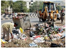
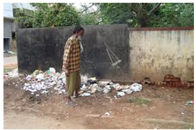
2.3.2. Solid Waste Disposal & Vehicle Parking on Roads
- The highest per capita solid waste generation in India is in Chennai (0.6kg/day)3. Majority of solid wastes are dumped in a mixed form in low lying areas & in open areas by Chennai Corporation. The Attitude of people is appalling causing the pile of solid wastes in the vicinity of the residential areas itself. Even though there is a proper system of collection, segregation & disposal of wastes, it is a serious environmental concern which has to be addressed separately.Chennai witnesses 425 new vehicles put on road every day causing pressure for motorable and parking space. Increase in impervious increasing the flood severity and later drought to follow. Increase in road space is accounting to only 3 - 4% when comparing with the developed cities like London (20-25%)[5]
3. Master Plan & Flood Mitigation in Chennai – A Quick review
- Flood Alleviation Scheme funded by Government with a cost Rs.3000 million was launched in 1998 focusing mainly on structural measures with the objectives like adequacy of flow in the arterial drainage system, safeguard against tidal and fluvial flooding, removing impediments, relocation and rehabilitation of encroachers. Cleaning of certain waterways and lakes was also undertaken under packages 2 and 3 of the scheme. Chennai City River Conservation Project which was launched in 2000[2] is aimed to improve the waterways, with an estimated outlay of Rs.17, 000 million. The Master Plan 1992–1993 incorporated Madras Metro Flood Relief/ Storm Water Drainage study outcomes in the form of structural and non-structural measures. Funds under JNNURM project have been visualized for implementation of underground sewerage schemes and detailed project reports are being developed. In 2010, the State Government has launched a massive flood mitigation project for the city, involving construction of new micro and macro drainage systems in four basins and making improvements to existing drainage, at a cost of Rs.1, 447 crores under JNNURM. The works like improvements works to divert surplus water, desiltation, strengthening existing city drainage network, etc.,
4. Findings & Recommendations
- Both humans and nature put together the ground for the perennial flood tribulations. The immediate need is to create a scientific inventory of water bodies and delineate flood zones within the city. The flood zone will have to be identified based on the location of the water bodies, natural drains, water shed area and it has to be made as a no building zone. More campaigns have to be conducted at the local level in order to create awareness to the public about the causative factors for the flood disasters. In addition to the above, the wide-ranging management measures will help Chennai to be relieved from the recurrent flood menaces almost every monsoon.An integrated approach, therefore, needs to combine watershed and land-use management with development planning, engineering measures, flood preparedness, and emergency management in the affected lowlands, while taking into account the social and economic needs of communities in both the highland source areas, and also the lowland flood-prone areas.
5. Sequence of Actions to Hurl out from the Flood Hazard (Both Structurally & Non-Structurally)
- 1) An integrated approach in Flood control and Management: It can be done by creating an unified flood management agency which acts as a nodal group to carry out the function of planning, co-ordination and monitoring of all the existing bodies like CMDA, Corporation of Chennai, Slum Clearance Board, CMWSSB, etc., in addition to the Disaster management agency2) Preparation of Topographical Map: Accurate topographical map (at least for the flood prone areas immediately) should be prepared by the local authority using GIS through digital elevation and terrain mapping.3) Distinguished Chennai River Restoration programme: It will support to alleviate the flood issues to a considerable level in addition to the Lake conservation programme[3].4) Prevention of Pollution: Impeding the disposal of untreated sewage, sullage and solid wastes will reduce the problem of choking the waterways which magnifies the flood crisis. 5) Clearing off the encroachments near the water bodies: All encroachments in and around the water bodies and flood plains should be cleared off and they have to be rehabilitated in other areas will subsequently reduce the flood crisis6) Scientific study about flood pattern: There is an immediate requirement about the study of flood pattern at least for 5 years using hydrological and hydraulic modeling techniques which guides us with a strategic planning collectively.7) River-front water development plans will help the stakeholders in managing the flood control plan effectively and also creates awareness to the public also about the advantages in maintaining the water resources. 8) A rapid assessment of flood inundation mapping is required before the monsoon starts so as to effectively alleviate the flood risks.9) Flood Mitigation Programmes: Construction of raised platforms, Flood walls, town protection works should carried out and monitored for effective mitigation of flood menace.10) Water shed management: Timely cleaning, de-silting and deepening of natural water reservoirs and drainage channels (both urban and rural) have to be taken up.11) Increasing Green cover: It requires more of planning and regulatory control over the open space and ground cover.12) Public Awareness: People should be made aware about the flood preparedness, response and mitigation measures.The above list of strategies is an illustrative and not an exhaustive but once implemented effectively will reduce the flood risks efficiently. Finally the approach in implementing the above said strategies should be at the micro to macro level approach for a fruitful result.
GLOSSARY
- CMDA –Chennai Metropolitan Development AuthorityJNNURM – Jawaharlal Nehru National Urban Renewal MissionCMWSSB – Chennai Metropolitan Water Supply and Sewerage BoardLakhs – Equal to one hundred thousand (100,000)MRTS – Mass Rapid Transit SystemLPCD – Litres Per Capita per Day
Notes
- 1. Tamil Nadu District wise Census, 20112. Based on the research project done by Centre for Environmental and Water Resource Engineering, IIT Madras3. Municipal Solid waste management in Chennai City by S.Esakku &
References
| [1] | Barroca, B., Bernardara, P., Mouchel, J. M. and Hubert, G. (2006), Indicators for identification of urban flooding vulnerability. Nat. Hazards Earth Syst. Sci., 6, 553–561. |
| [2] | CMDA (2007), Master Plan - II for Chennai Metropolitan Area - 2026, March 2007, Chennai Metropolitan Development Authority, Tamil Nadu. |
| [3] | CPREEC (2008), Urban Flood Studies for Chennai under NIDM Project, CPR Environmental Education Centre, Chennai. |
| [4] | Calder, I. R. and Ailward, B. (2010), Forest and floods: moving to an evidence based approach to watershed and integrated flood management. Water Int., 31(1), 1–13 |
| [5] | Gupta, A. K., Nair, S. S., Chopde, S. and Singh, P. K. (2010), Risk to resilience: strategic tools for disaster risk management. NIDM, ISET-US, US-NOAA and DFID, International Workshop Proceeding Volume, NIDM, New Delhi, p. 116 |
| [6] | Gupta, A. K. and Nair (2010), S. S., Flood risk and context of land uses: Chennai city case. J. Geogr. Reg. Plann., , 3(12), 365–372. |
| [7] | Leopold BL (1968). Hydrology for- Urban Land Planning - A Guidebook on the Hydrologic Effects of Urban Land Use. U.S. Geological Survey, Washington, D.C |
| [8] | Mirza, M. M. Q., Warrick, R. A., Ericksen, N. J. and Kenny, G. J. (2001), Are floods getting worse in the Ganges, Brahmaputra and Meghna basins? Environ. Hazards, 3, 37–48. |
| [9] | UNDP-India, (2010). Panel discussion on urban floods in India (Background note). UNDP-India and NDMA, Government of India, E-circulation |
| [10] | Ramachandra, T. V. and Varghese, S (2003), Exploring possibilities of achieving sustainability in solid waste management. Indian J. Environ. Health, 45(4), 255–254. |
| [11] | Sundaram AM (2009). (MIT, Manipal). GIS model to assess Chennai city’s environmental performance, using green-cover as the parameters. Map World Forum. Hyderabad, GIS@development (website). |
| [12] | Srinivasan RK (2008). White Foam: The Chennai Riverbed does not have space to breathe. Down to Earth, February 2008. |
| [13] | Turner, B. L. (2003) et al., A framework for vulnerability analysis in sustainability science. Proc. Natl. Acad. Sci. USA, 100(14), 8074–8079. |