Hisham El. Shimy
Architectural Engineering Department, Pharos University, Alexandria, Egypt
Correspondence to: Hisham El. Shimy , Architectural Engineering Department, Pharos University, Alexandria, Egypt.
| Email: |  |
Copyright © 2012 Scientific & Academic Publishing. All Rights Reserved.
Abstract
the proposed research is vital for the case study since it is linked to the environment spatial surrounding representative in Alexandria. The central section, especially disease schematic in the slum areas, like the manor of the Azbat-Aljama which is one of the largest slums, since it is densely populated, small in space and new in terms of method of treatment and technology implementation. The central section is also clear through the use of land readjustment planning system in respect of the way. As for the treatment of the technical implementation, it can appear through the use of digital system in the planning of data collection using a GPS device and recorded on a digital GIS database. The research is a pilot research study in the way of the treatment and technical implementation of the study itself. It assesses and takes advantage of the application results for assessing the requirements and material and physical resources. The crisis of dissemination is applied to a flat section which is the Middle district of Alexandria as a first stage for strategy city planning.
Keywords:
Sustainable , Development, Slums, Readjustment , Planning , Alexandria, GIS-SWOT
Cite this paper:
Hisham El. Shimy , "Sustainable Development of the Slum Areas in Using Readjustment Planning System Aljama Slum Area as Case Study", Architecture Research, Vol. 2 No. 5, 2012, pp. 68-80. doi: 10.5923/j.arch.20120205.02.
1. The Hypothesis
Adopt the basic premise of research on the linkage between Sustainable Development of the slums and the mechanism used in the study and analysis of the social, environmental and economic situation. Through a new Minute numeric mechanism linking social, environmental and economic, that forms a triangle of Sustainable Development, using the system schematic land readjustment planning. This system is an improved and developed one to apply to the slums. The reason for choosing the area of Azbat-Aljama as a case study is because studying theoretical clustering is more densely in populated areas in Alexandria, 22,071 people / acre, and is a vital example that can be a study area since it is small and limited 0.003 Km2 with a population of 7622 People [1], high density of 254433people / Km2 (10690 people / acre) which will facilitate the process of studying and analysing. For these reasons, it can be use as a pilot research [2].
2. The Research Design and Methods for Achieving the Stated Goals
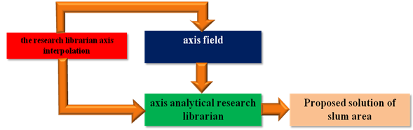
The design of the structure of the research is based on three key axes which vary from empirical research to office, field office and research analysis. A. Axis of Heuristic Search Bureaus:Axis supports the research librarian bug that gathers information on the style of the study which is analysed from the reference of scientific debate and Applied Research. This can be illustrated through a series of steps that apply to research the subject of study.The Axis of Heuristic Search Bureaus consist of :i. The concept of Sustainable Development, urban communities’ determinants of application and mechanisms implementation.ii. The problem of global slums, and an explanation of global statistics and their impact on the general outline of the cities.iii. The problem of slums and their impact, the outline of the city of Alexandria, an inventory of the problems and distributed to the living. The study would focus on more densely populated areas.B. The Field Axisi. Study planning for facilities and services and make sure that the maps are signed by using micro-.devices such as GPS and knowledge of environmental problems.ii. Identifying the field survey of the views of the slum residents to observe the social conditions, economic and environmental traps and even basic problems through:• Seminars which focuses on group discussions.• Qualitative study.C. Axis of Analytical Research Bureaus: This sets the axis range of data and results analytical studies in the of field draft studies that are analytical-based planning system proposed in terms of data, information and land readjustment planning. This allows forming a database for the study area that can easily be incorporated in a GIS program. This database enables reaching the general perception of the current situation of the slum region and find out the most important determinants of economic, environmental and social problem for the fabric of urban community and the problem of slum systems that can be a conceived proposal for the scheme of sustainable development of the region without causing the destruction of the communal fabric so as to create a bridge between society and development partners who form the region's slums and those responsible for the development. 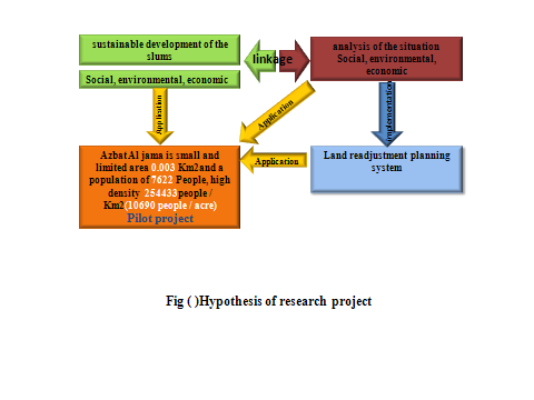 | Figure (1). Hypothesis of Research (3) |
3. General Goals of the Research
A. Develop a scientific approach applied to the study and analysis of the slum entity to get to the strengths and weaknesses without tearing the physical and social fabric.B. Achieving the sustainability of the region's urban slum community in the social, environmental and economic aspects.C. Using Research as a pilot research standard module to determine the physical needs and financial requirements for the development of slums. It is also used to determine the standard unit for measuring the cost-effective utilitarian to the slum community to be the index of the development for other similar areas within the same region in the common characteristics of environmental, social and economical. The persons working in the same or related fields, in which its products are possibly directed to a scientifically or technically literate reader are determined in this list:i. The Governorate of . ii. The Fund Slums.iii. The Regional Centre of the Urban Planning Authority. iv. General Authority for Urban Planning. v. Habitat.
4. Introduction
It has recently appeared that third world countries, given the causes of poverty and the weakness of the potential governmental institutional as illustrated map of the distribution of slums on the flat world, are where the highest proportion of the slums are stationed. In South America and the Caribbean 2.5% . 4 % of the population are concentrated in either the North Asia or the countries of West Africa and 1% . 1.5% of the population are either low percentage differ between the countries of North Africa; central Africa and Eastern Europe and of 0.6% of the population [4].By studying the slums on the flat Africa, we find that the prevalence of slums states that the population of Northwest and Northeast of Africa is about 81% .100% of the total area of this country ,the east African and the south and east Africa and the West African the average rate is 61% . 80% of the total area of this country but the lower rate is 21% .40% of the area of this country (4)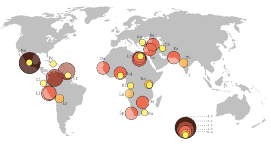 | Figure (2). Map of Slums Area in the World and Population Density of the Slums (5) |
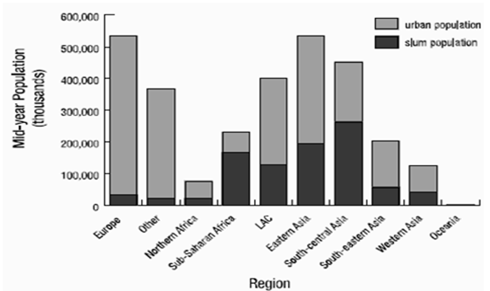 | Figure (3). Distribution of urban population by slum and non-slum ,in the world(5) |
 | Figure (4). The position of Slums in terms of Development and Removal (7) |
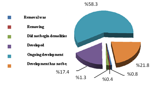
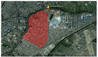
The main problem in slums area is how to development people who leave their and make a relationship with original urban pattern in city (metropolis) so the slums area are the new extenuation of the city, the Hypothesis depends on development slums area using land readjustment system to adding new services and infrastructure to improve those area without any changes of neighbourhoodThe problem of informal settlements in Egypt is one of the most serious problems due to its economic, social and security impacts which jeopardize the safety and stability of the society. Nationally speaking, we find that the percentage of slums in Egypt is 21%. 40% of the total area of Egypt; according to a study by the General Authority for Urban Planning and Development Fund of the United Nations in 2005. The number of slum dwellers in Egypt is about some 6.2 million people (6) and rose to 14,797,619 million in 2007 with a total number of 1171 slums. So the percentages are 58.3% slums removed 17.4% slums development and 21.8% slums under development [7].Whether regionally or locally, we find the share of Alexandria are 30 random areas until September 2007 with a total of 1,763,362 people who had shrunk to 22 major areas with a total of 1,084,353 people [8]. These statistics are according to the report of the Alexandria Governorate 2008 which examines the distribution of slums at the level of Alexandria. We find that it appears to a great extent on the outskirts of the city eastward, Department of Park 7 regions and the west action 5 areas [9].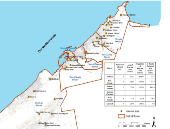 | Figure (5). Statistical Map Showing the Number of Squatter Areas in Alexandria (7) |
Research problemResearch problem is concentrated in the absence of a development dimension for the slums on the long term, neglecting the social aspect of the region's population in terms of neighbourliness and harmony, which is central and vital, and the lack of system-minute digital which is a reliable identifier for the development of problems and obstacles. This system is also a database for finding solutions for planning in an accurate and impartially unreliable. In absolute human appreciation the logic and rationale of the study proposed is to achieve sustainability as the key objective of the development of the region. This has created a development dimension on the long term achievement of the neighbourhood, friendship and database for finding solutions to planning in an accurate and impartially not dependent on the absolute human appreciation and personal perceptions. This system is an improved and developed one to apply to the slums. The reason for choosing the area of Azbat-Aljama as a case study is because studying theoretical clustering is more densely in populated areas in Alexandria, 22,071 people / acre, and is a vital example that can be a study area since it is small and limited 0.003 Km2 with a population of 7622 People [1], high density of 254433people / Km2 (10690 people / acre) which will facilitate the process of studying and analyzing. For these reasons, it can be use as a pilot research [2].This Research is a Measure of Importance:The importance of the research is the fact that in slums lies the risk of social and environmental needs of the resident population by the community, especially with the emergence of social ills such as rape and security problems and political as terrorism, theft. All this is a time bomb that distributed within the urban fabric in the city and negatively affects the sustainable development plans of the city.The sustainable development is the most important methods used to bring new development to urban communities, because by return it benefits the social, economic and environmental of the region’s random micro-.scale and benefit the neighborhood and the city.The region is Azbat-Aljama which is one of the most important and first areas in the study (pilot research for a variety of reasons):Azbat-Aljama is the Central District of the most densely populated city of Alexandria with a population of 22,071 people / acre. It is the smallest area of slums in Alexandria, and thus can be studied within a specified period linked to the maximum limit for the proposed research (two years) (3).
5. International Trends to Deal with the Slums Area
It is a review of previous studies in the area of slums on several axes as the world global experience, local trends and Egypt Ministry of Housing, research implemented, the development of slums and the system of financing the Fund's slum and regions of Alexandria. Examine the shortcomings and gaps in policies and practices in order to learn the points that need to be addressed. Through the review, it is possible to draw a picture of the proposed research methodology in terms of content, installation and addressing the gaps that the previous explanation of the methods created which is how to deal with slums to reach the best solution planning by investigating the sustainability of communities in slums area. The World Global Experience (7):The experiences of countries in the world depend on the economical level and the political background of these countries.
5.1. The Experiences of Developed European
The Experience of Spain in Barcelona:The plan is based on the central, regional and local governments, aimed at integrated development of the beards, improving the type of housing and the removal of degraded housing to replace public places and services. Non- governmental interventions depend on the implementation of development programs in collaboration with agencies and believe in the principle of community leadership and to find more than one source of capital.
5.2. The Experiences of Developing in East Asian Countries
The Experience of India in Mumbai Action plan relies on the provision of drinking water, sanitation and street lighting. It is funded from the central government and the World Bank. It aims at integrating the contributions of the private and government sectors, relieving the ancient people in their new units as well as establishing a control point for the relief of the population during the development process to ensure the absence of a beneficiary and a placebo. The City of Kolkata: It was a new land that was purchased for residential housing for indigenous people. However, they refused to distance from their work places and adopted the plan of improving the environment and developing the slums rather than removing them and act only as one of the houses and the regularization of property for housing.
5.3. The African Countries
Experience of the Sudan Passed through series of stages; starting from the re-planning of informal settlements to giving compensation to the slum dwellers. The reasons for the success of the development programs are the interest, respect and cooperation between the tribes and the government, the development committees’ representative of the population, being subject to implementation and the existence of financing.
5.4. Latin American Countries
Mexico's Experience Adopted to improve the infrastructure and make the land, on which the slum population dwellings, belongs to them. Providing loans for housing improvements for Sustainability of the development of slums requires the provision of financial resources through the development stages to convert it to an urban area within the urban fabric of the city and maintain the absence of an echo of the random again. Now, it is possible to provide social, demographic and economic data on the number and characteristics of slum dwellers from the Central Agency of Public Mobilization and Statistics. Based on census data 2006, as well as using GIS and the Ministry of Local Development, the available data about slums are characterization of a year to their current situation (developed . removed) and the size and number of inhabitants, but no descriptive data for social and economic characteristics of the population (10). The Most Important Lessons Learned from International Experiences:1. Study the environment well in order to design appropriate developing programs.2. Empowering marginalized slums groups. 3. Unite efforts between governmental and non- governmental organizations to implement development programs; establish the principle of community leadership and to find more than one source of capital.Current gaps in the world global experience are limited to the absence of a standard mechanism which supports decision makers to deal with the region based on random numbers and data, indicators and detailed site maps which enable them to take decisions and identify development trends and forms.Mechanisms and Policies Used to Deal with the Slum in the World are:1. Mandatory Evacuation.2. Slum Clearance and Relocation.3. Upgrading in Place.4. Clearance and On Site Development. Local Trends and Egypt Ministry of Housing and Research Implementation and Development of Slums and the System of Financing the Slums’ Fund (11)
5.5. Criteria for Demolition and Development of the Slums in Egypt
a. Housing situation in the region, the number and density of population, the deterioration of infrastructure and the extent of the streets and main services.b. Random location of the region and its association with the economic value of land, investment possibilities and the size of compensation in case of removal. c. The decision to phase is made in the case of large area regions, high population density in some parts, buildings in the state of poor construction and land space and nest. In the case when the dotted area is of small and low population density, sometimes there are parts of the premises with poor construction, land space and huts and exist within the pocket of the city and have high value of land or property state. A decision is made whether the development of the large slums that are densely populated, large, adjacent to the old urban fabric of the city and state of the buildings is bad or not.
5.6. Problems during the Stand-Off Deal with the Slums in Egypt
a. Forcing slum dwellers to leave the property. b. Compensation between land and buildings. c. The availability of alternative sites to establish the population during development. d. Lack of cooperation between slum dwellers during the development or removal, which is violence and conflict. e. There are no plans for the buildings organization or narrow streets which demolish the possibility of implementing construction works for utilities.f. The absence of idle state-owned serve to establish new housing for population transfer.
5.7. Analysis of Experiences-Governmental Development of Slums in Egypt
a. Lack of attention to improve the integrated dimension and development of economic, social and humanitarian aspects.b. The absence of urban planning.c. Lack of funds and the full budget may lead to dividing it over the years, which lead to lack of access to works that have been implemented.d. Reduce the role of civil society, businessmen and investors.e. No coordination between agencies working in the area of slums such as Ministry of Local Development, Ministry of Housing and Urban Planning Authority. All this limit the performance activities.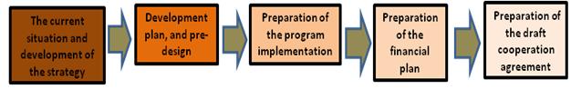 | Figure (6). The Proposed Research Plan of the Fund Slum (11) |
 | Figure (7). Methodology of Research (3) |
f. Slums of accurate data can be relied upon in planning and putting forward effective solutions for the development of these slums and the lack of accurate information on the social and economic characteristics and living conditions.g. The spread of drugs, unemployment, illiteracy and poor security.h. Low level of income ranging from 300 pounds to 600 pounds per month.i. Development, which is not comprehensive to all the streets and all the internal services such as hospitals and schools.j. The presence of resistance to the evacuation of the people slums.
5.8. Governmental Mechanisms Updated for Development of Slums in Egypt: (11)
Governmental mechanisms have been established as one of the governmental attitudes developed for development of slums in and in accordance with Presidential Decree 305/2008. UNFPA has identified the criteria for classifying areas into two: 1 – Insecure Areas.2 – Unplanned Areas.Its only mission is the preparation of National Action Plan for the development of slums, managing development researches and monitoring their implementation in coordination with the civil institutions. The priority is given to areas that are safe, based on international references for funding requests for the local, followed by preparation of an action plan for the development research by identifying those involved in the proposed activities and the spatial and temporal framework for this plan.
6. Methodology
The idea of research plan to solve the research problem depends on scientific methodology. The method used in the research on a set of tools necessary to achieve systematic required depending on the nature of each phase.
6.1. The concept of Land Readjustment
Is to assemble small rural land parcels into a large land parcel, provide it with infrastructure in a planned manner and return the reconstituted land to the owners, after deducting the cost of the provision of infrastructure and public spaces by selling of some of serviced land. (12)Seen in figure annex planning how to deal with an example to be developed using a land readjustment system where the straightening paths streets and building blocks while maintaining the urban fabric of the region's natural as possible. When to Use This Method? (13)The method is especially useful when: Scattered and unsuitable subdivisions hinder private sector land development.Older urban structures should be reorganized; and there is a need for extensive provision of infrastructure and services.Whatever name it goes by, there are generally seven key stages of LR (14):a. Initiation: Usually by petitioning to the local authority from a majority of property-owners in a particular area. Dissenting landowners may be compelled to contributing their lands to the research.b. Declaration: The boundary limits of the scheme are set under enabling legislation, by a public or private agency.c. Plan: Preparation of a redevelopment scheme, determining future uses and re-planning the road and plot layout. This can identify, for example, buildings for demolition or preservation, street closures, proposed public areas and allocate plots to the development agency to fund infrastructure.d. Measurement: Calculation of plot areas before and after readjustment. Plot sizes can be reduced by approximately 20% for roads, and up to 50% for public spaces and facilities.e. Costing: Estimation of future market value of readjusted plots, and costs of infrastructure.f. Allocation: Fully serviced plots are reallocated back to landowners, usually located as near as possible to the original position.g. Implementation: Enabling agency funds infrastructure through the sale of reserve by auction or cost-equivalent plots.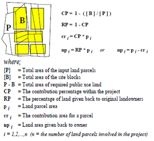
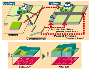 | Figure (8). Mechanism of land Readjustment in 2Dimension and 3Dimension (15) |
What are the conditions needed for LR to work?For LR to work there must be:■ A legal regulatory framework, with dispute resolution mechanisms.■ Adequate cadastral records.■ A development agency that has public confidence and appropriate technical expertise.■ Political acceptance and willingness to share development values between public agency and private land-owners.■ A functioning land market with accepted valuation rules and rising land values.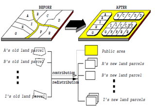 | Figure (9). Fundamental Calculations for Determination of Land Parcel’s Contributions (15) |
6.2. Advantages
There are many advantages of using land readjustment [16]: It provides an opportunity for a planned development of the land and infrastructure network. It avoids the problem of the so-called "leap-frog" development where different types of land uses and densities are mixed. Developers in many Asian countries often have a problem because plots in the urban fringe are small, irregularly shaped and lacking access to public roads. Furthermore, as many of these plots are not for sale, it is often difficult to find a sufficient number of plots next to each other and, thus, building development becomes scattered. Land readjustment is an attractive method to influence the location and timing of new urban development since it is becoming increasingly difficult to obtain public support for the use of expropriation for land development and infrastructure provision. The method is typically supported and sometimes even initiated by the landowners since they would make considerable profit on the research. Contrary to the obvious alternative methods for city development, land banking and expropriation, it also avoids the costly and unpopular government procedure of acquiring land. Unlike expropriation, land readjustment will return a major part of the land to the landowner. Ideally, a partnership for development should be formed between the public sector and the landowners. It is therefore very important that close links are established during the research. It provides an opportunity for the provider of infrastructure and services to recover the incurred costs as well as getting access to lands for this purpose. As cost recovery is a major obstacle for municipal governments in most Asian countries, this would probably be the most important component. A welcomed side effect is that land readjustment requires that the land ownership situation to be clarified and an accurate land registration system provided. This should also lead to increased public revenues from property taxation. If administered properly it could provide increased equity in land distribution. Not only among the landowners within the area, but it could also be a means of providing access to land for low-income housing.By using digital program (GIS) and statistical tables we can form the map of development.New method, used in the processing and analysis, is the land readjustment planning sketch. It a system based on processing of the problems inhalers planning, environmental social and economical; whether addition, removal or both, according to the requirements of study and consistent with the empirical study and field. There is a group of difficulties that may arise, such as the development of houses that impede the development process and requires ideas planning depending on the substitution of new homes with unsurpassed capacity, the largest of all the above mentioned investigation objective of the research study area in order to determine the sustainable development of slum area.
7. Plan of Problem Solving
7.1. Problem Statement
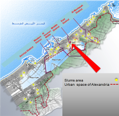 | Figure (10). Map of Distribution of Slums Area in Urban Space of Alexandria and Location of Pilot Research (1) |
Research problem is concentrated in a set of points: 1. The lack of long-term after the stage of development. 2. Non-.interest in the social aspect of the population of slum area with neighbourliness and harmony which are central and vital. There is another reason for the land readjustment that the majority of the population is engaged in the same area.3. The lack of precise digital system relied upon in identifying the development problems and obstacles and which can be used as a database for finding solutions to planning in an accurate, personal impressions and delay the interest of the people first has been corrected through: 1. Sustainability is a prime target for the development of the region of slum and this has created a long-term development dimension.2. Establishing the principle of land readjustment planning so as to maintain the social aspect of the slum population in terms of neighbourliness and harmony.3. Use of digital system depends on the use of computer technology GPS in the surveying, signing of the slums, identification of facilities and services, buildings and population distribution of the Azbat Aljama area of slum and recording electronically on the GIS. Thus it is possible to find an accurate system that identify digitally and is reliable for the development of problems and constraints. The database is to infer planning solutions in an accurate model is computable with the people needs.
7.2. Research Significance
The importance of the research is the fact that in slums lays the risk of social and environmental needs of the resident population by the community, especially with the emergence of social ills such as rape, security problems and political such as terrorism, theft and collected a time bomb that distributed within the urban fabric in the city negatively affect the sustainable development plans of the city. The sustainable development of the most important methods used to bring new development urban communities, urban and rural, because it gives return on social, economic and environmental benefit of the region slum micro-scale and benefit the neighbourhood and the city major.Through statistical data of the Central Agency for Public Mobilization and Statistics, according to the 2006 census for the Shyakt Azbat Aljama which (2) include slum area of( Azbat Aljama . study area ) and other areas :1. The total area of Shyakt Azbat Aljama is 0.49 Km2 but the area of slum zone is 0.003 Km2, the edges of slum zone (Azbat Aljama) are already out of limits of Shyakt Azbat Aljam, in the right side which located in Shyakt Alnozha.2. The number of families is 10744, population is 40501 and 20769 males by 51% and the number of females is 19732 by 49%. This indicates the balance of the ratio between males and females. 3.The number of people who attained less than 40 years constitute 34458 people with a percentage of 85%, which indicates that the vast majority of the population during the next era (20 years) will pose a problem of housing sector.4. The number of qualifications (less than average to university) is 24161 people out of 31051 people by 77% and the illiteracy rate is about 23%. This shows that the majority of the population possesses an appropriate level of education, which helps maintaining an awareness of the development researches. 5. Total labor force of 15 years are over 12799 people by 45%, while people outside the labor force by 55% representing 15193 people. This indicates a deficiency in income and financial resources for more than half of the population in the region. 6. The number of workers in government and business sector are 3951 by 14%, while the working groups in the private sector are 24041 and by 86% which indicates that the majority of the population work in special professions is encouraged to embrace the thought of the overall economic development of the region.7. The number of working groups in scientific careers and higher 2474 rate of 9% and the rest in occupations such as workers and technicians by the number 25518 people 91%, indicating the need to encourage small craft and craft activities for the development of the region. 8. The number of families living in apartments or the whole house 10510 by 98% and the rest in rooms, huts or landfills by 2%, which helps to promote the creation of residential buildings. Average household size of 3.77 per capita and overcrowding 1.07 person / room is an appropriate rate.9. The number of households available and the means of formal power are 10536. 98%. The number of families available and the way water official housing are 10548.98%. The number of families who have housing connected to the sewage are 10705.99.6%. All these statistics indicate that the majority of housing is available with inadequate basic facilities suitable for housing in the incident with the networks of public facilities in the future. If we make a comparison between the shyakt Azbat Aljama and slum zone (Azbat Aljama) Fig (14), we find that: →The area of slum zone is 0.003 Km2 but the area of Shyakt Azbat Aljama is 0.49 Km2, so the percentage is 0.61%. →The population of slum zone is 7622 people while the population of Shyakt Azbat Aljama is 40501 people therefore, the percentage is 18.8 %. →The densely populated of slum zone is 2540666 people/ Km2 but that of Shyakt Azbat Aljama is 82655 people/ Km2. This makes the densely populated of slum zone of Azbat Aljama 30.7 times of the densely populated of Shyakt Azbat Aljama.Associated with site selection study (Aljama slum), its presence on the axis is vital for the city of Alexandria. Mahmudiyah canal is a vital research that is under preparation and implementation for the establishment of the centre of the movement of elongated connecting East and West of the city in the south to allow a new height of development, especially as there are a number of slums along the route of the canal Mahmudiyah. This is a pilot research for development and upgrading along the axis of the channel and sustainable development on the local level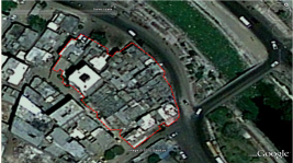 | Figure (11). The Edges of Shyakt Azbat Aljama and Edges of Slum Zone (Azbat Aljama) (17) |
 | Figure (12). Edge of Built.-up area (3) |
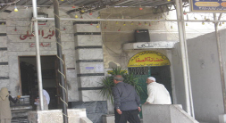 | Figure (13). The Name of Slum Area is Aljama becau4e the mosque of Al bar Alkabaly(3) |
 | Figure (14). Upgrading the Random Extension of Azbat Aljama Slum Area from 2000 to 2009 |
The area of Aljama slum is the most important and the first areas on the study (pilot project ) for several reasons:• It is in the central district of Alexandria which is the most densely populated area of Alexandria 22,071 people / acre, as well as being the smallest area of slums in Alexandria. Thus can be studied within a specified period linked to the maximum limit for the proposed research which is two years.• Through this study and analysis of the draft study as a slum (Aljama slum), the study field and office can be completed during the 16 months.• Due date style used digital land readjustment planning system as a way to develop and re.-plan the slums. This is done in terms of the use nature of the system of land readjustment planning system in planning of the slums. The system was often used in the re-.planning of the devastated areas after the war using newer computer technologies. An example of these technologies is GPS which is used in the signing of slums, identifying facilities, services and buildings, and population distribution of the whole area of slum and recording them electronically on a GIS program. Then this information is used to infer the output of land readjustment planning system. 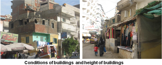 | Figure (15). Conditions of Buildings (Azbat Aljama) (3) |
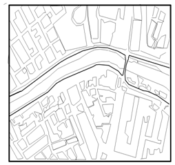 | Figure (16). Cadastral Map of the Location of the Slum Area Azbat Aljama (18) |
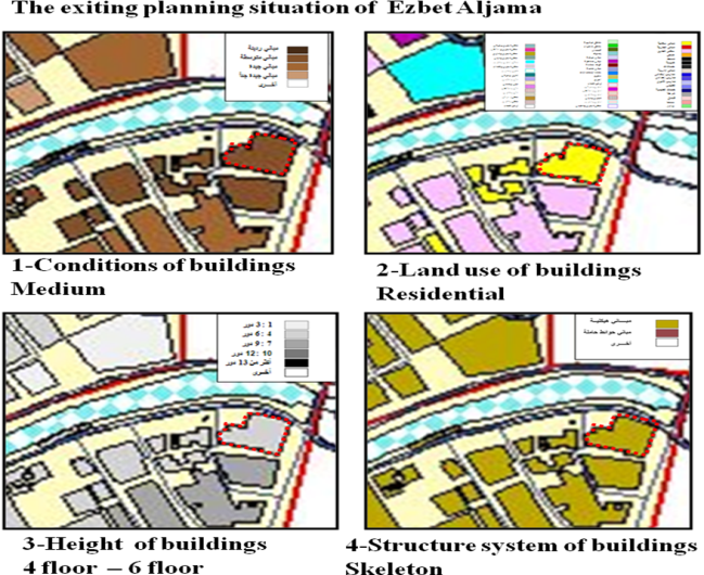 | Figure (17). The Exiting Planning Situation of Azbat Aljama ( 18) |
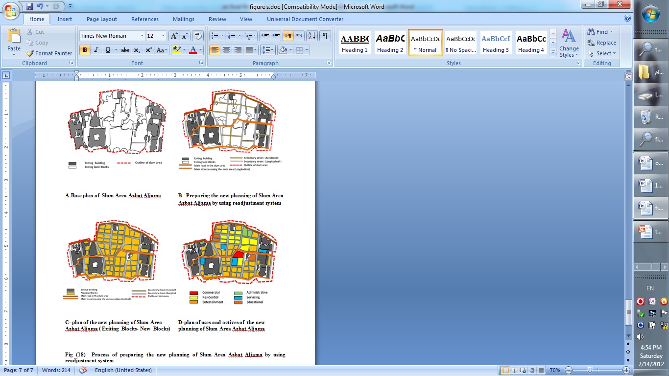 | Figure (18). Process of preparing the new planning of Slum Area Azbat Aljama by using readjustment system |
8. Analyse the Using of Land Readjustment Planning System by SWOT Analysis
8.1. Environmental side
A- Strengths 1-The availability of resources and assets of environmental and recreational and tourist distinctive suit the tourist activity2-Diversity of the natural environment of plants and animals3-The availability of resources and good elements of the activity of fishing on canal Mahmudia 4-Topographic diversity which giving the character of each region5-climatic conditions are mild for most of the yearB-Weaknesses1-Environmental pollution represented in the industrial area Smouha 2-Scarcity (lack) of green spaces3-The presence of low-lying areas in the site of the projectC-Opportunities1-Providing a source of water to help irrigate the green areas2-The mild Climatic conditions given the sustainability during the periods of the year of tourism activitiesD- Threats:1-Environmental pollution may destroy the natural environment of plants and animals2-The presence of erosion in the southern border overlooking the international route3-The presence of Pockets of ground in the site of the project
8.2. Social Side
A-Strengths 1-Lack of accumulation of a population in the region2-There is no special social nature of the inhabitants of the region, helping to set up new communities without causing discord between indigenous people and immigrants B-Weaknessesالقاموس - عرض القاموس المفصل1-Low level of education2-Decline in living standards for families3-Lack of communication between residents of the north and south of study area C-Opportunities1-Make a comprehensive development to the region to improve the level of social and educational2-Linking the east bank of canal Mahmudia and west bank canal Mahmudia by internal roads networks3-Job opportunities in the region of the elements of attraction for stability in the regionD- Threats:1-Migration of the original people from the project location in case of remove and replacement of actives and uses without any development for recent actives 2-Lack of recreational and economic incentives encourage the transition to the region3-The difference between the workplace and housing for migrants residents which giving difficulty in moving from Alexandria to the project area
8.3. Economic Side
A- Strengths 1-resources and assets of environmental and archaeological characteristic suitable for tourism activity2-The richness of land suitable for cultivation of environmental3-The availability of resources and distinct elements suitable for fishing 4-Availability of raw materials and workers necessary for the industries5-Willingness of the people of the region to contribute to economic development projectsB-Weaknesses1-Poor infrastructure needed for economic development (roads, transport, communications)2-Limited financial resources allocated to economic development3-The absence of a clear plan and mechanisms for economic development, represented in tourism, fishing and exploitation of natural resources in the region4-Lack of local administrative staff capable of managing the economic development of effective security projects and direct the agricultural and clothing and housing and to create the right climate for economic openness projects and implementation of productive projects and local service and follow-up activities of unions and associations, cooperative bodies and encouraged. a-Migrationb-High unemployment and poverty for the people of the region ” most of them workers and craftsmen “5-High proportion of slum-dwellers6-Poor participation of women in economic activity because of traditions and social customsC-Opportunities1-Interest and support of political leadership2-The presence of Axis International Coastal Road3- Project to modernize the Egyptian industry4-The project of establishing the industrial zone Rashid5-The presence of the petroleum industry projects on the coastal road and the exploitation of the proximity of exotic ports and airport 6-Willingness of investors from outside the city to participate in economic development projects.7-Manufacturing environment-friendly one of the projects appropriate to the project site, including provides job opportunities for the indigenous people and to immigrants D- Threats:1-Lost the political support with the passage of time through the stages of the project study2-Waste facilities and resources available in the projects that do not commensurate with the resources of the region3-The inability of the local economy to meet the needs of local and regional4- Aggravated the unemployment problem5-Increasing poverty and declining living standards, where data indicate the Human Development Report, Alexandria governorate that the total population under the poverty line 22%6-Pollution of the environment as a result of poor environmental management of some industrial and economic activities 7-Lack of regulation of fishing in the region
9. Results
a. The system of land readjustment planning an effective and contribute to the Use of facilities and civil services done by the people in the region slum because it depends on the amendment limited in configurations planning (streets . Buildings).b. find areas of planned and complete facilities and services within the region Slum help dump Overcrowding slums logically and that a search for the best, particularly as it is within The vicinity of the slum.c. Use of a GIS program describing the information derived from the study highlights, its accuracy and confirms the content of the collected data which will help in easing the decision. making either by developing or removal in one easy way to convince the people to collaborate with the executive bodies of the governorate.
10. Conclusions
a. Overcrowding slums means that there should be incentives and points of attraction in the region schematic that attracts the presence of population migration and talking to outside the region, which requires the search for these points to activate it in order to build on the outline of the sustainable development of the study area.b. Careful planning of the study area, which meets the requirements of sustainable development for the region, helps indirectly in reducing the annual requirements for the residential units at the county level because of the solution used in location of the problem and puts on a central solution.c. Sustainable Development of the slums helps encouraging the people of the of self development area through the presence of safety and reassurance in the region’s investment in the region as they develop their own world belonging to them. An example of this is shops and small workshops.
11. Recommendations
a. A system used in the demolition of counterproductive slums. It does not care about the social aspects of the population. This is the basis for sustainable development. It is, therefore, recommended to search using alternative systems such as land planning readjustment planning system and only removal of the hazardous areas.b. To benefit from the research for the pilot research circulated to slums’ administrative divisions in Alexandria.c. Resources of the first slum region sources are used in the sustainable development of the region that are represented in human resources, which is a catalyst for the functioning-measures of development through cooperation with the implementing agencies responsible for hydration of the area slum.d. Provision of soft loans to people in order to develop their homes as well as helping them to feel the extent of government’s support for them, stimulate their sense of personal ownership of it and access it from their limited personal.
References
| [1] | Ministry of Housing, Utilities and Urban Development in collaboration with the UNDP, the United Nations and the Canadian International Agency for Development and the Canadian Mortgage, "Stat of the built environment and housing indicators in seven Egyptian cities", Alexandria, January ., 2010. |
| [2] | Alexandria Governorate ,Central Agency for Public Mobilization and Statistics, Census ,2006. |
| [3] | researcher |
| [4] | Wakely, P., Clifford, K., Walker, A., Soave, A., , "Understanding Slums: Case Studies for the Global Report. ", DPU, UCL and UN.HABITAT.,2003. |
| [5] | UNHCR,UNRWA, world urban station prospects ,2004, UN.Habitat,2003, WHO,2004. |
| [6] | OnlineAvailable: http://unescap.org/huset/m_land/chapter10a |
| [7] | Alqtqat, H., leading researcher, "Slums in the provinces of the Arab Republic of Egypt : an analytical study of the status and best approach to handle ",Decision Support Center , Cabinet ,May , 2008. |
| [8] | El Helbawy, H., "Comprehensive Development Strategy of Alexandria towards a strategy for development of slums", World Bank. ,2007. |
| [9] | General Secretariat of the local administration , "A total number of slums", Ministry of Local Development. |
| [10] | Online Available: http://.worldbank.com |
| [11] | Financing Fund slums, "Reference Manual. Preparing a draft action plan to develop slum areas", Presidency of the Council of Ministers, Cairo, April, 2009. |
| [12] | UN human settlement, "Municipal Land Management in Asia: A Comparative Study", Chapter 10, selected initiatives on access to land for the urban poor (cont.), Land readjustment, Cairo,2003. |
| [13] | Online Available: http://.urban.wikia.com/wiki/Land pooling |
| [14] | Doebele, W.A., "Conceptual Models of Land Readjustment., In Minerbi, L. et.al., ed., Land Readjustment: The Japanese System. ", A Lincoln Institute of Land Policy Book, Boston, USA ,1986. |
| [15] | Seele, W,"Land Readjustment In The Republic of Germany., In Doebele, W.A., ed., Land Readjustment: A Different Approach To Financing Urbanization", Lexington Books, USA ,1982. |
| [16] | T. Yomralioglu . T. Tudes . B. yzun . E. eren., "Land Readjustment Implementations in Turkey", fifth International Housing Congress, Department of Geodesy and Photogrammetric Engineering, Karadeniz Technical University Trabzon – Turkey,1996. |
| [17] | Online Available: http://earth.google.com |
| [18] | Alexandria governorate, "Management of Urban Planning Department of Housing", 2010. |
 Abstract
 Reference
 Full-Text PDF
 Full-Text HTML