-
Paper Information
- Paper Submission
-
Journal Information
- About This Journal
- Editorial Board
- Current Issue
- Archive
- Author Guidelines
- Contact Us
American Journal of Geographic Information System
p-ISSN: 2163-1131 e-ISSN: 2163-114X
2023; 12(1): 43-50
doi:10.5923/j.ajgis.20231201.03
Received: Apr. 18, 2023; Accepted: May 8, 2023; Published: May 23, 2023

Geospatial Appraisal of Crime Hotspot Distribution in Bauchi Metroplis
 Abstract
 Reference
 Full-Text PDF
 Full-text HTML
Victor Fredrick1, Vandu Umaru Lazarus2, 3, Mary Emmanuel2, 3, Ibrahim Hyedma Bwala2, 3
1Department of Surveying and Geoinformatics, Abubakar Tafawa Balewa University, Bauchi, Bauchi State
2Survey and Geo-informatics, Federal College of Land Resources Technology Kuru-Jos, Plateau State
3Office of the Surveyor General of the Federation, 8 Yawuri Street, Garki II, P.M.B. 6203, Abuja, Nigeria
Correspondence to: Victor Fredrick, Department of Surveying and Geoinformatics, Abubakar Tafawa Balewa University, Bauchi, Bauchi State.
| Email: |  |
Copyright © 2023 The Author(s). Published by Scientific & Academic Publishing.
This work is licensed under the Creative Commons Attribution International License (CC BY).
http://creativecommons.org/licenses/by/4.0/

The dynamics of crime are peculiar to location, time and nature of the vulnerable communities under its threat. Bauchi communities have suffered a range of criminal acts against the good people including armed robbery, kidnapping, phone, car and motorcycle snatching. These crimes are more frequent and/or rapid in some communities than others. Clustering of criminal activities in some selected areas led to the labelling of such areas as hotspots. However, effective mapping and geospatial understanding of the hotspots remain a concern. Hence, geospatial approach was adopted to evaluate the crime hotspots that pose increase security threat to communities in Bauchi LGA. The research findings shows that 70% of the communities’ crime hotspot are randomly close to each other, 15% of the communities shows that the crime hotspot is clustered with more effect, only 15% of the communities are free and disperse. The analysis established that criminal activities have increasing impact across multiple location due to the clustering and randomly closeness of the hotspots to each other which further increase the vulnerable of the communities to different typology of crime. The most prevalently identifiedcrimes across the communities include; phone snatching inSabonKaura behind ATBU, Mararaban Liman Katagun, Inkil, and Tirwum. Motorcycle snatching is prevalent at Sabon Kaura behind ATBU, Mararaba Liman Katagun, Bakaro, Gudu Hausawa, Gudu Seyawa, and Tirwum. Burglary is prevalent at Gwallameji, Wunti Dada, Gudum area, Gombe road, Fadaman Mada, Inkil, Yelwan Tsakani and Sabon Kaura. The study established that the ratio of security personnel to the population of Bauchi LGA which is estimated at 645,000 is below global standard which necessitate the strategic deployment of the personnel to critical crime hotspot. In view of this, it is recommended that security agency should adopt geospatial technology to aid their strategy for combatting the security threat across Bauchi LGA and utilize the technology to frequently produce security threat maps and build their mitigation measures around it to effectively utilize the available human resource. It was also recommended that the State should create job opportunities and skill acquisition training for unemployed youth roaming the streets.
Keywords: Appraisal, Crime hotspot, Bauchi Metropolis
Cite this paper: Victor Fredrick, Vandu Umaru Lazarus, Mary Emmanuel, Ibrahim Hyedma Bwala, Geospatial Appraisal of Crime Hotspot Distribution in Bauchi Metroplis, American Journal of Geographic Information System, Vol. 12 No. 1, 2023, pp. 43-50. doi: 10.5923/j.ajgis.20231201.03.
Article Outline
1. Introduction
- Criminal occurrence has an undesired cost in terms of unfriendly activities in the environment which constitute danger, violence or threats to the life and properties of the populace. The frequency of criminal activities reported from different location made some of these location crime hotspots and they are numerous across Bauchi metropolis. The crime are not limited to human slaughter and injury, armed robbery, kidnapping, drug trafficking, car and motorcycle snatching and other offences specified by the security agencies. The resultant effect of such crime in Nigeria often leads to death, and psychological and bodily pains of the victims (Fredrick et al, 2023). The distribution of crime across the landscape or globe is geographically not random since crimes are human phenomena (Chainey, 2014). For crimes to occur, offenders and their targets - the victims and/or property - must exist at the same location for a period of time (Ejemeyovwi, 2015). However, recent worries about this value as well as the pervasiveness of security issues that have a direct impact on society have elevated it to the top of the list of safety priorities. Violent confrontations and crimes have significantly increased in recent years in a variety of contexts, including towns, farms, streets, road, companies, places of worship, and residences. Unexpectedly, educational institutions are not exempt especially the primary and early secondary schools (basic education) which is the foundation of education as aptly stated by Uloko and Ada (2022). This violence is pervasive around the world, not only in Nigeria. (UNICEF, 2015).According to Ademola (2013) and Wahyuningtyas, et’al., (2020), Nigeria's proclivity for a variety of behaviors and societal negative change that endanger the lives of the people is no longer news. The top trending news in the country are security threat by terrorists, banditry, hoodlums, Assassination, political thugs, youth militancy, kidnapping and hostage-taking of passengers, and the Boko Haram crisis are just some of them. Insecurity has been a threat to social and environmental development in areas that crime with clusters of hotspots. The facilities that are most affected are schools, residentials, and commercial environments are pose to the threat. (Uloko and Ada, 2022; Aly and Chris, 2021 & Barbra, 2020). In areas as such, the security agencies have made every effort to reduce the rapid spreading of the crime, but it does not appear to be yielding the desired results. The research emphasized the importance of environmental security and safety which include prevention of loss of life and property, security risks that do not exclude residential buildings, commercial and schools Azgaku, (2014). Vincent (2021) has this believes that Nigeria's security risks have a significant impact on the world security image, looking at the dangers of cybercrime and kidnapping in Nigeria, and how they have affected Nigeria's security image in the international community. Based on his findings, Vincent (2021) suggested that Nigerian leaders should address internal issues such as unemployment, poverty, and the unequal distribution of national values and resources, all of which have contributed to recent security challenges. This align with different studies that underpinned these socioeconomic factors as the causes of the insecurity and conflict in Nigeria which is reenforced by the poor attention to education of the populace, provision of social amenities and governance issues. In recent years, Nigeria and its northern region have faced a variety of security challenges, such as terrorism, banditry, kidnapping and adoption for ransom, election violence, armed robbery, drug trafficking, car and motorcycle snatching. All these criminal activities are perpetrated mostly under the influence of hard drugs, Indian herms and alcohol unscrupulous elements in the community; bandits, violence extremism organization (VEO) and terror groups. Bauchi Metropolis is not an exceptional with the rapid spreading of criminal activities to extend of kidnapping the state Governor’s elder brother among other case so also the crime hotspot. However, most criminal incidents go unreported, and this continued to impact the ability of the security actor to respond effectively in addition to the underlaying challenges understaffed security personal in term of their ratio to the population (Fredrick, et al, 2023). According to Richard (2021), around 10–20% of crime incidents are reported, while the remaining 80–90% are not documented. Bauchi metropolitan relies on the security agency to offer optimum protection in its particular area and it schools by sending troops around. In the recent kidnapping and robbery situations, the presence of security guards is felt after the incident rather than during the incidents.With the rise in security threats, geospatial techniques as a catch-up terms for a variety of approaches can be used by security agencies to map and analyze the distribution of security personnel across an area, crime hotspot and also monitor the security challenges in a location of interest. GIS is a set of tools and processes that interact with geographical data and are utilized in analysis and decision-making. It is required in a wide range of areas, from government to the general public, from business to social care, and from science to military. GIS is defined as "a powerful set of tools for storing and retrieving at will, transforming, and displaying spatial data from the real world for a specific set of purposes," whereas GIS is defined as "a computer-based system to aid in the collection, maintenance, storage, analysis, output, and distribution of spatial data and information" (Bolstad, 2012). GIS offers advanced analysis tools and comprehensive data packages for proximity analyses to safety facilities in the event of an emergency, as well as demographic information (Shoman et al., 2018, van Genderen, John., 2017).GIS provides advanced analysis tools and complete data packages for proximity analysis, which can analyze the nature of security in environ (Mokoena, T. B and Musakwa, W. (2018) and Shoman et al, 2018). The tools can help in analyzing the level of the security threats in the location and identifying the optimal route for safety order to improve and enhance the level of security in such areas and also provide solutions to the problems of kidnapping and adoption that have been trending in the country at large (Yenisetty, eta’al.,2020). The geospatial technique could be used to enhance security by determining the proximity of Security Agencies stations, personnel posted around communities in other to reduce the level of environmental vulnerability. Spatial distribution analysis could provide the security agency with detailed information about areas that are most vulnerable to security threats by displaying the inter-visibility, descriptive picture, and location in order to improve and enhance the level of security in such areas and also provide solutions to the problems of kidnapping and adoption that have been trending in the country at large.Security and safety of an environment is critical to productive life because of it pivotal role in political, economic, and social development of the people. However, various studies in recent years have shown that communities are not so safe anymore due to the activities of criminals and the increase in distribution of crime hotspots which remain a thing of concern to the people of Bauchi and its environment. Most communities are faced with numerous security and safety threats which are seen as human factor that prevent societal and environmental development. This research tends to use geospatial technology to show security proximity analysis, crime hotspot analysis and areas that are vulnerable in order to enhance security and improve safety.
2. Methodology
- Application of Remote Sensing and GIS: In all 25 crime hotspots identified in Bauchi Metropolis, handheld GPS was used to collect geometric data (locational coordinate of the crime hotspot) the data collected where further validated and exported to ArcGIS 10.7.1 environment for security threat analysis, proximity analysis and "Nearest Neighbor Analysis" (NNA) and the result are displayed inform of thematic maps and chart respectively. The step-by-step strategy adopted in the process of implementing the field work is as follow; reconnaissance (field and office), data collection (primary and secondary data), recording, data analysis and presentation. The study area is Bauchi Local Government Areas (LGA) in Bauchi Central Senatorial District, Bauchi State, Nigeria. It is geographically located between latitude 10°15'26.23" and 10°16'30.25" North of the equator and Longitude 9°46'36.32" and 9°47'44.94" east of the Greenwich meridian. Bauchi Local Government has a population of 493 810 people and a surface area of around 3 687 km2 (NPC. 2008). The map of the LGA is presented in Figure 1 below. The state (Bauchi) is located in the North-Eastern geopolitical region with Kano and Jigawa to it northern border, Taraba and Plateau to the southern border, Gombe and Yobe eastern border, and the western border is Kaduna respectively. With a population of roughly 6,530,000 in 2016, Bauchi was the seventh-most populated city in Nigeria and the fifth-largest in the region. The state is multi-ethic with 55 identified tribal groups including Bolewa, Jarawa, Sayawa, Gerawa, Kirfawa, Turawa, Warjawa, Karekare, Zulawa, Fa’awa, and Butawa among others. Geographically, the State is divided into the Sudan savanna in the south, the dry semi-desert Sahelian savanna in the north, the drier semi-desert in the west, and a small piece of the highland Jos Plateau in the southwest.
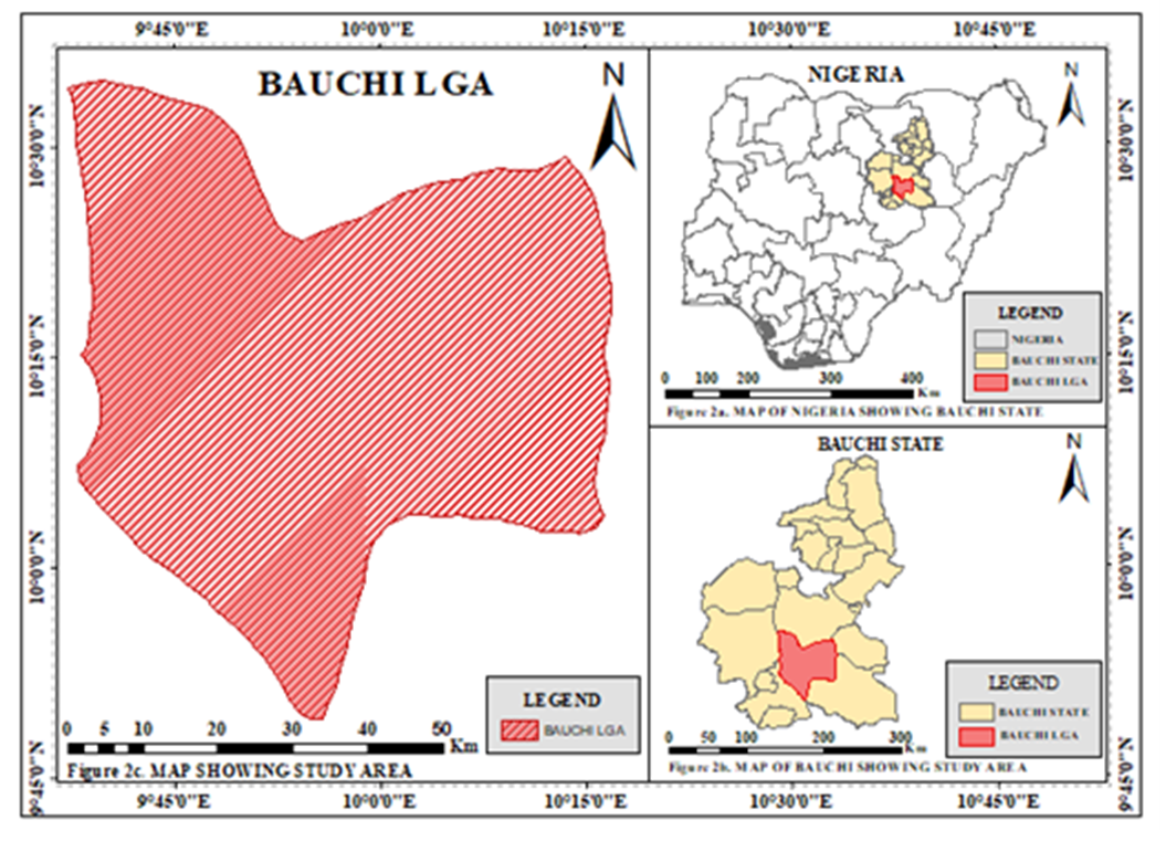 | Figure 1. Map of the study area |
3. Results and Discussion
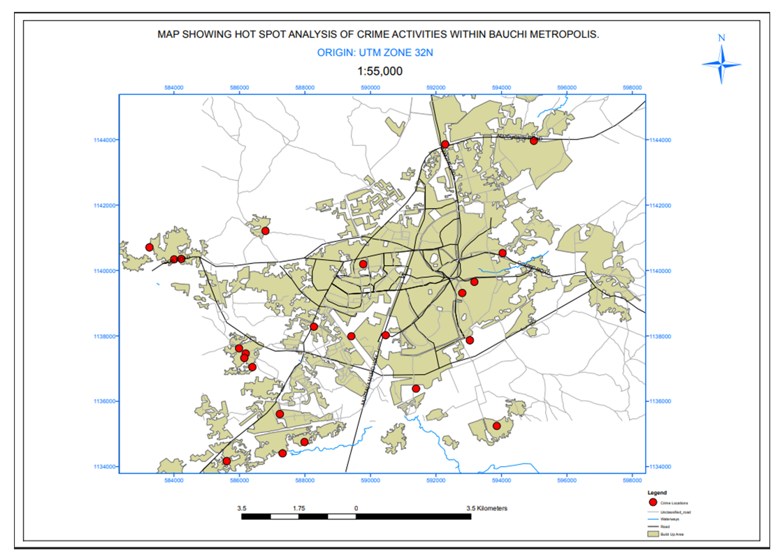 | Figure 2. Map of Bauchi Metropolis showing Hotspot Analysis of Crime |
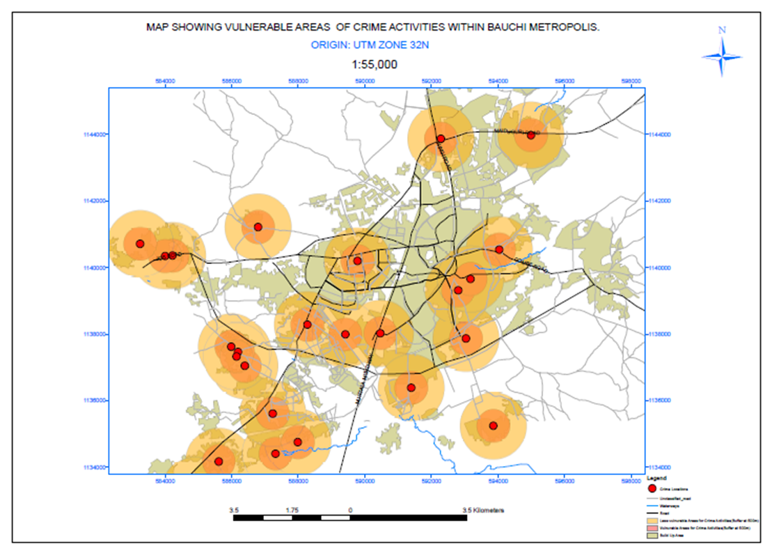 | Figure 3. Map of study location showing the vulnerable areas around the crime hotspot |
4. Discussion
- The dynamics of crime and security threat in BauchiBauchi state have suffered security and safety threat which have affected life and properties of most resident, the dynamics of the happening shows that the resultant effect of the threat emanated from the socioeconomic nature of the state including the rate of poverty in the state, unemployment, neglect and unaccompanied children and adolescents as well as religion intolerance among others. Bauchi is bordered with states that are experiencing security challenges and other security threat such as Boko haram conflict in Yobe state and the banditry issues of Kaduna state. Bauchi has a record of harboring and being used as a hiding place for criminals, bandits, terrorist groups, VEOs like Boko Haram and ISWAP members. With the increment in unemployment amidst the rising issues of poverty and economic challenges which result to idleness and intake of drugs that exposes the youth to criminal activities within and outside their communities. These render most of the communities vulnerable due to the wider spread of unscrupulous youths with the tendencies of crime. Although there were no active terrorism in the state, between 2012 to 2015, terrorism groups such as Ansaru, and another group of Boko haram tried to establish their camps in places like Toro, Dass, Ningi and Alkaleri LGAs of Bauchi state. Nigeria's military and Department of State Security Service (DSS) combined efforts flushed them out of the State.In the past three years, Bandits have gradually found their foot in the State. There have not been records of massive attacks on locals, but they have engaged in a series of kidnap which has forced some individual to relocate from their homes and villages to communities in the urban city that are safer. The activities of bandits are prominent in Toro, Ningi and Alkaleri LGAs; also, kidnapping has been prominent in LGAs like Bauchi, Tafawa Balewa, Toro, Ningi, DASS, Ganjuwa, and Kirfi. Most communities in the State are vulnerable because aside from the Local government headquarters, most other places in the LGAs lack presence of significant security forces. There is no presence of conventional security, lack of access roads, poor communication network, and extended response time increases the risks of these communities. The population of people in Bauchi Local Government was compared with number and/or distribution of police (personnel) in the state. The results show that the ratio is far from the United Nations standard which suggested that the ratio of population to one police at 450:1. This further validated the vulnerability of the people of Bauchi state in terms of proportionality of security response. This could further be deduced as influential to the vulnerability and the widespread of the crime hotspots in Bauchi metropolis. The Crime Hotspot Clustering The rate at which crime are being committed is a thing of concern to the state security agencies and the residence of the communities that are most vulnerable to the impact following the trend from 2020 to 2022 which shows that there is increment in the perpetration of crimes around some noticeable community, these criminal activities crime attributed to the rapid increase in the crime hotspot in the environment. Research has shown that areas that harbor abnormal activities like drug pushing, smoking of Indian hemp and other practice of social vices are vulnerable to a greater extend. Residence that dwell with 0-500m radius are more vulnerable to the effect from the crime hotspot, but those who leaves 500-1000m away experiences limited direct impact because of the distance between them and the crime hotspot areas.In most cases, areas that habour criminal activities which are known as crime hotspots are mostly hideout places for criminals and evils are being plan before its execution. Area with cluster crime hotspots established by the geospatial data presented in figure 4 were marked with the prevalent of crimes such as phone snatching in Sabon Kaura behind ATBU, Mararaba, Inkil, and Turum; Motorcycle snatching is prevalent at Sabon Kaura behind ATBU, Mararaba Liman Katagun, Bakaro, Gudum Hausawa, Gudum Sayawa, and Tirwum. Burglary is prevalent at Gwallameji, Wunti Dada, Gudum area, Gombe road, Fadama Mada, Inkil, and Sabon Kaura etc. Such criminal activities have been perpetrated on average of every day according to findings from interviews with security agencies in December 2022. The finding further established that most crimes are undocumented because they are not reported especially as most victims believes that they might not recover their properties even if reported to security while others allegedly hold that reporting cases of such to security will cost them some funds even when they will end up not recovering what they lost. Hence, they believe that it is best to save the additional cost of reporting and loss only the things that are stolen.
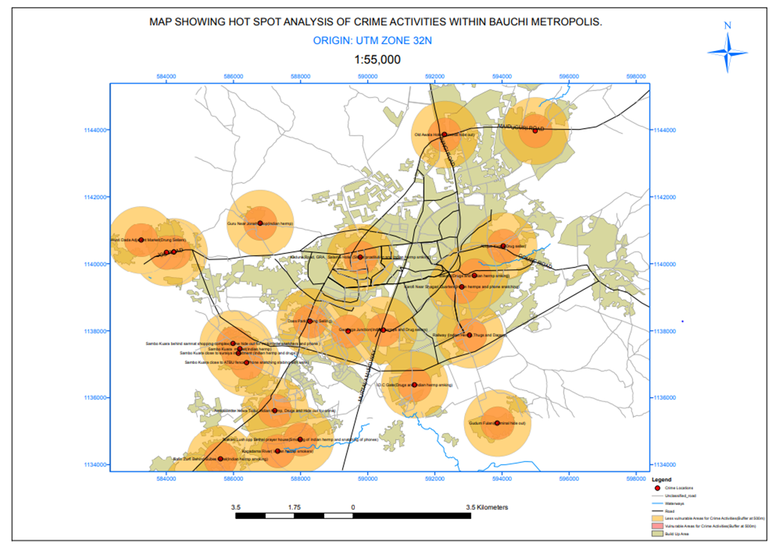 | Figure 4. Composite buffer map of crime hotspot and it level of vulnerability |
5. Summary of Findings
- The result shows the distribution of crime hotspots and dynamics of crime trends over the years and the communities that are vulnerable due to cluster of crime hotspot and inadequate workforce of the security agencies. There is a need for security agencies to adopt geospatial approaches to mitigate crime risks. There is a rapid increase in criminal activities within Bauchi LGA due to the non-spatial distribution of security personnels. Looking at the crime rate growth, if drastic measures are not taken, then with time, no place will be safe. Suppose the agencies adopt a geospatial approach to monitor the crime hotspot. In that case, it will help curb the insecurity problem, and also, the personnel posting should be at an outpost 500 to 1000 meters interval which will help in curbing the crime rate.
6. Conclusions
- The rapid increase in crime hotspots is a threat to the security of Bauchi LGA. Geospatial approaches offers a helpful means to evaluate the communities vulnerability. The nearness of the hotspot or clustering of the hotspots determine intensity of insecurity within the environment. The findings have helped to establish that criminal activities are at increase due to the rapid increase in crime hotspots as established by information gather from study through interviews with security agencies. Based on the findings, 70% of the crime hotspot are randomly close to each other mean the communities hosting this hotspot is randomly close to the other hotspot. 15% of the crime hotspots were found to be clusters with the communities being very close to each other, and 15% crime hotspot are disperse which mean that the communities are far apart. This implies that only 15% of the crime hotspots exert intensive impact on each other where different communities feels the impact of multiple crime hotspots whereas 70% randomly feel the impact of other hotspots on their location. 85% of the area within Bauchi LGA often experience security and safety threat base on the increase of crime hotspots. also looking at the population density of Bauchi LGA (645,000) and the ratio of security personnel (police) to individuals is grossly insufficient and far less than the United Nations standard of police ratio 450:1.
7. Recommendations
- Based on the findings, the following recommendations were made:There is a need for the Bauchi state government to create job opportunities and poverty alleviation programme to empower the youth with skill for unemployed and creating employment opportunity for others. This will positively impact the state by reducing the crime rate within the LGA and the entire state because poverty and lack of job opportunities among the youths are major triggers of the criminal activities. Moreso, there is an urgent need to increase the security agencies' workforce. The need to deploy modern technology such as geospatial technology among others in combatting crimes considering the rapid increase in criminal activities within the state cannot be over emphasized. Knowing full well that security agencies have Intelligent Units such as the State Intelligent Bureau (SIB), Zonal Intelligent Bureau (ZIB) and Federal Intelligent Bureau (FIB), having GIS knowledge and adopting geospatial technology will strongly complement their efforts and enhance the impact of the security services they offers.