-
Paper Information
- Paper Submission
-
Journal Information
- About This Journal
- Editorial Board
- Current Issue
- Archive
- Author Guidelines
- Contact Us
American Journal of Geographic Information System
p-ISSN: 2163-1131 e-ISSN: 2163-114X
2023; 12(1): 1-27
doi:10.5923/j.ajgis.20231201.01
Received: Dec. 30, 2022; Accepted: Mar. 8, 2023; Published: Mar. 28, 2023

Biodiversity Information Systems in Geospatial Applications for Protected Area Management
 Abstract
 Reference
 Full-Text PDF
 Full-text HTML
Md Rahimullah Miah1, Md Mehedi Hasan2, Jorin Tasnim Parisha3, Alexander Kiew Sayok4, Ahi Sarok5, Mohammad Belal Uddin6, Md Sher-E-Alam7, Md Shoaibur Rahman8, Md Main Uddin Miah9, Md. Amir Sharif10, Md Aktar Hossain11
1Department of IT in Health, North East Medical College and Hospital, Affiliated with Sylhet Medical University, Sylhet, Bangladesh
2Department of Law, Green University of Bangladesh, Dhaka, Bangladesh
3Sunamganj Government, Satis Chandra Girls’ High School, Sunamganj Sadar, Sunamganj, Bangladesh
4IBEC, Universiti Malaysia Sarawak (UNIMAS), Kota Samarahan, Sarawak, Malaysia
5Faculty of Social Sciences, Universiti Malaysia Sarawak, Kota Samarahan, Sarawak, Malaysia
6Department of Forestry and Environmental Science, Shahjalal University of Science and Technology, Bangladesh
7Department of Law and Justice, Metropolitan University, Sylhet, Bangladesh
8Department of Agroforestry and Environment, Hajee Mohammad Danesh Science & Technology University, Dinajpur, Bangladesh
9Faculty of Forestry and Environment, Bangabandhu Sheikh Mujibur Rahman Agricultural University, Gazipur, Bangladesh
10Department of Accounting and Information Systems, Begum Rokeya University, Rangpur, Bangladesh
11Institute of Forestry and Environmental Sciences, University of Chittagong, Chittagong, Bangladesh
Correspondence to: Md Rahimullah Miah, Department of IT in Health, North East Medical College and Hospital, Affiliated with Sylhet Medical University, Sylhet, Bangladesh.
| Email: |  |
Copyright © 2023 The Author(s). Published by Scientific & Academic Publishing.
This work is licensed under the Creative Commons Attribution International License (CC BY).
http://creativecommons.org/licenses/by/4.0/

The study explores a structure for a Biodiversity Information Systems (BIS), giving pertinent instructions and guidelines to the Space Research Remote Sensing Organization (SPARRSO) for surveying the protected areas (PA) of Bangladesh, particularly the Lawachara National Park in Moulvibazar district. SPARRSO facilitates interdisciplinary research associations at divisional, national, regional and international levels and provides a clearing house mechanism (CHM) to distribute information to affected parties. To date, Bangladesh has no effective national biodiversity database with clearing house mechanism services as defined by the Aichi targets of the Convention on Biological Diversity (CBD). There are many problems that national bio-networks face to manage biodiversity data of PA. This study provides a unique view of the tools being used to enhance the upcoming development of this national biodiversity database, which will use observations, interviews, reconnaissance findings, literature reviews and existing laws and policies. The study incorporates the collective technological information from stakeholders e.g., biodiversity specialists, forest officers, ecologists, conservationists, environmentalists, policy-makers, park managers, judges, environmental lawyers, academics, network managers, co-management team leaders and adjacent local village leaders. Almost 64% of the respondents agreed to develop the dynamic National Biodiversity Database for protecting biodiversity of PA and 53% of users stated that this BIS is more applicable than traditional systems. The study represents the indispensable connectivity with the World Database on Protected Areas (WDPA) for wide-ranging datasets, data sharing, data-indexing, web-publishing and electronic reports to CBD with the help of National Resources Information Management Systems (RIMS) and SPARRSO. Finally, this study suggests future research trajectories using a new collaborative approach to drive the methodological agenda and recommends ways to further incorporate the information systems integrating next generation biodiversity conservation outlooks.
Keywords: Biodiversity, Informatics, Protected Area, Database, Geospatial
Cite this paper: Md Rahimullah Miah, Md Mehedi Hasan, Jorin Tasnim Parisha, Alexander Kiew Sayok, Ahi Sarok, Mohammad Belal Uddin, Md Sher-E-Alam, Md Shoaibur Rahman, Md Main Uddin Miah, Md. Amir Sharif, Md Aktar Hossain, Biodiversity Information Systems in Geospatial Applications for Protected Area Management, American Journal of Geographic Information System, Vol. 12 No. 1, 2023, pp. 1-27. doi: 10.5923/j.ajgis.20231201.01.
Article Outline
1. Introduction
- Bangladesh is a ratifying state party to the Convention on Biological Diversity (CBD), which states that by 2015 each state party should develop a National Biodiversity Strategy and Action Plan (NBSAP) as a conservation policy instrument in accordance with the Aichi Biodiversity Target 17 (CBD, 1992). The research relates to national park, so the choice of policy instruments is the first three in number instruments, which are legal, in-situ and informational instruments. The study considers policy instruments through examining NBSAP to determine whether and how the NBSAP contributes to mainstreaming biodiversity across policy sectors using Clearing House Mechanism (CHM) in Bangladesh to halt biodiversity loss. Conservation of biodiversity within national parks requires rapid access to data such as the spatial and temporal distribution of species and their habitats within environmental context (Murray et al., 1997) through using digital conservation (Hobern et al., 2014). Previous research on national park of biodiversity informatics excels its origins (Wurman, 1989) to utilize databases and the internet as a tool to manage and publish data on biodiversity information (Costello and Vanden, 2006; Costello et al., 2006). According to Article 6 of CBD, each party should develop the Biodiversity Clearing House Mechanism (BCHM) for enhancing digital conservation (CBD, 1992), but till date, Bangladesh has not been involved in BCHM according to the global requirements as well as stakeholders’ communication (DoE, 2016). Rapid loss of biodiversity tends to be at the foremost of conservational issues as they potentially disturb the bio-systematic functions (Sachs et al., 2009; Kaeslin et al., 2012; Alamgir et al., 2014; Sohel et al., 2014). This loss of biodiversity is one of the most thoughtful global environmental apprehensions (dos Santos et al., 2015), which have been raised during various planetary precincts (Steffen et al., 2015) as a domineering worldwide issue for several years. Everyone exploits biodiversity but none can conserve it in the absence of dynamic policies, institutional support, stakeholder engagement and ecotourism services, measures to control invasive alien species and application of conservation technologies. Protected areas (PAs) are often targeted on lands with the least political resistance to their establishment, and thus typically face the least anthropogenic threat. Due to the lack of accurate assessment, the development of indicators and indices can lead to the understanding of updated rules and regulations related to biodiversity with protected area management, allowing monitoring and adaptation of changes and trends over time.Biodiversity is the diversity and variability of living organisms (CBD, 1992). National Parks (NPs) play an instrumental role in conserving biodiversity and provide many benefits to society. Globally, these benefits are increasing. Their multiple functions need to be considered to enable the integration of relevant environmental, economic, social aspects and geospatial applications for their management (Liaison Unit Vienna, 2000).To date, there is no up-to-date comprehensive biodiversity information system in geospatial application models incorporating various relevant political, environmental, socio-cultural, technical, economic, institutional and legal processes for national park biodiversity management. The aim of the study is to develop scientific models in geospatial technologies for biodiversity management in protected areas.
2. Materials and Methods
- The study included different parameters, which followed as.
2.1. Application Method of Information Systems for Digital Conservation
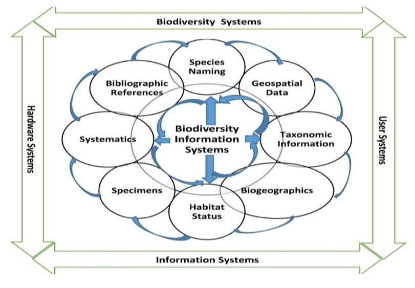
- The study identified and analyzed the application of information systems for digital conservation in connection with Biodiversity Clearing House Mechanism (BCHM) and Online Integrated Information Systems (OIIS). To undertake this analysis, it has been required to extend and search beyond peer reviewed publications, documentations, books and other scholarly works. Systematic review methodology tends to avoid these in their emphasis on data quality (Pullin and Stewart, 2004). Six key dimensions are identified (Arts et al., 2015) (Figure 1), which has a substantial impact on biodiversity conservation. This approach related to horizon scanning exercises, which aims to identify relatively unknown phenomena at the earliest possible stages (Pettoreli et al., 2014; Waddle et al., 2003; Wagtendonk and De Jeu, 2007; Van der Wal et al., 2015). The study tried to assess different biodiversity related databases, such as: (i) National Plant Species Database, (ii) Wildlife Database, (iii) National and Global Biodiversity Experts Databases, (iv) Online National Report of Bangladesh to CBD, Digital Monitoring Conservation System of LNP, (v) Visitors Database with revisit information system to LNP, (vi) HRIS and Infrastructure Facilities of LNP, and (vi) Co-management system and list of Co-Management Council (CMC).
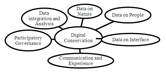 | Figure 1. Data Collection Approach for Digital conservation (Arts et al., 2015) |
2.2. CHM Web Menu Scoring Method
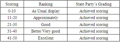
- Till to date, Bangladesh has not developed clearinghouse mechanism as a State Party. 10 country groups of randomly selected Asian CBDs compared the analysis of CHM web menu performance among them. These State Parties are Bahrain, Cambodia, China, India, Indonesia, Japan, Malaysia, Myanmar, Republic Korea, and Yemen. The Selected State Parties of CBD, n=10, Specific Parameters of State Party’s webpage performance (CHM, 2010; FWI, 2012), such as: (a) Image/map scrolling, (b) National biodiversity menu, (c) National Protected Area menu, (d) Policy and NBSAP menu, (e) National Experts menu, (f) Link with other sectors, (g) Display Language status, (h) Link with CBD, (i) Link with social media, and (j) Search menu. The average Scoring indicates the grading and ranking of each Party’s Clearing House Mechanism as shown in Table 1.
|
2.3. Making Users Dataset for Biodiversity Information Systems
- The user database for biodiversity information systems prepared using MS Office 2021 including database table, data query, data form and reports. It also showed the relationship among datasets of Lawachara National Park including documenter analysis for decision-making of the existing database.
2.4. Field Observation
- The researcher observed relevant website, Library, Institution, Forest Areas and relevant places. To determine the scope and position of the Biodiversity Web Portal in terms of proposed plant diversity, species diversity and genetic diversity. During observations about landscape, agriculture and forest, questions were developed for use in geo-data collection.
2.5. Data Analysis, Presentation and Interpretation
- All general information on biodiversity and national park phenomena including legal arrangements in protected areas and their diversity, status and distribution were checked for accuracy from various sources and sources of information were also verified. Information regarding the initiatives of the authority towards the conservation of biodiversity was collected through relevant secondary information and field survey. Then the information were included in the preparation of data master sheet and incorporated into convenient forms used in the result and discussion section. The data were compiled and analyzed for presentation and interpretation using standard data analysis software like MS Office Suite 2021, and R programming version 5.3.
3. Results
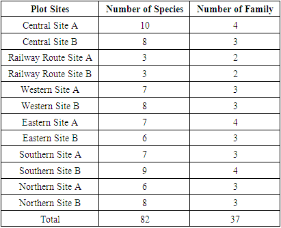
3.1. Tree Diversity of Lawachara National Park
- From the field surveys, the study recorded 1,318 tree individuals from 82 species and 37 families from 36 subplots at Lawachara National Park, which as shown in Table 2. Tree diversity index enhances to the establishment of afforestation and reforestation programme inside at Lawachara National Park.
|
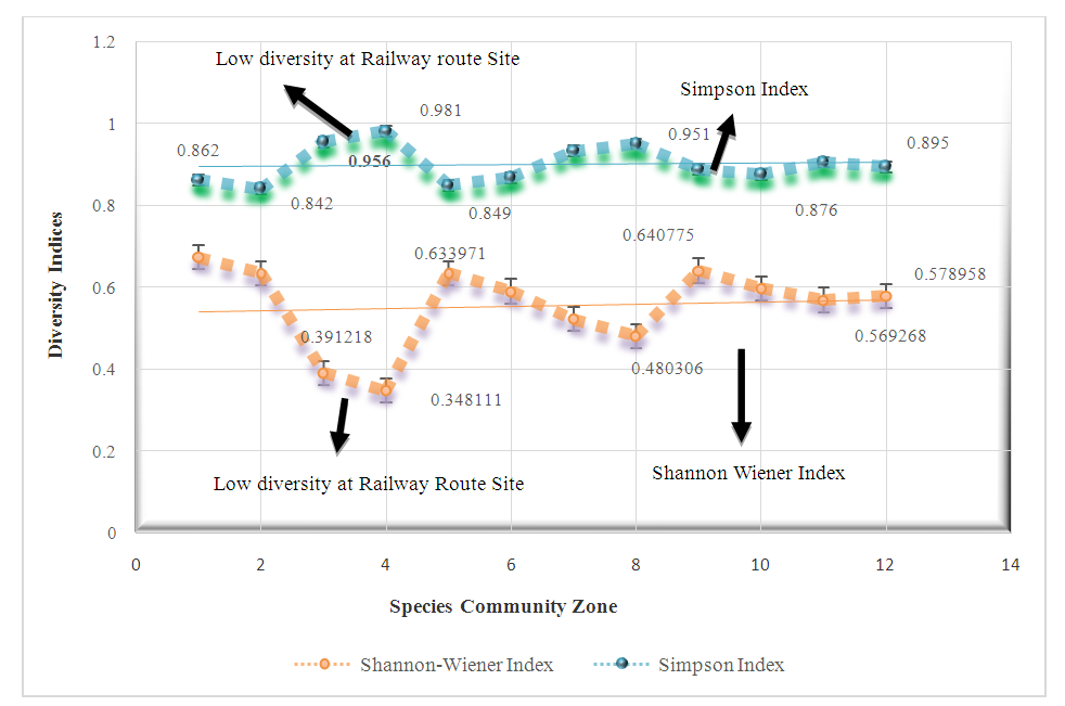 | Figure 2. Tree Diversity index of Lawachara National Park |
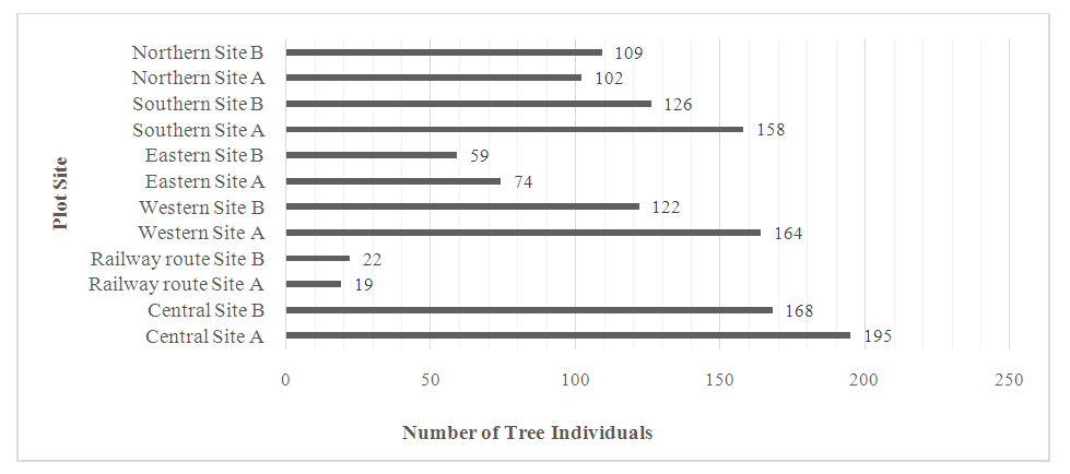 | Figure 3. Tree species Individuals in different Plots |
3.2. Wildlife Critical Condition of Lawachara National Park
- From the field observation, sheltered wildlife status of Lawachara National Park (LNP) is captured by threats. These Threats to wildlife and their habitations are multifarious and pervasive in the Lawachara National Park. According to IUCN (2017) these are 39 mammalian wildlife consisted in LNP, out of them, almost 23% of the known species are threatened, 18% are vulnerable as well as 5% endangered, which as shown in Figure 4. The study showed the status of vulnerable and endangered of wildlife conservation in the LNP with risk assessment. Some wildlife of LNP were killed by Railway and vehicles during movement the road / route (SOD, 2016).
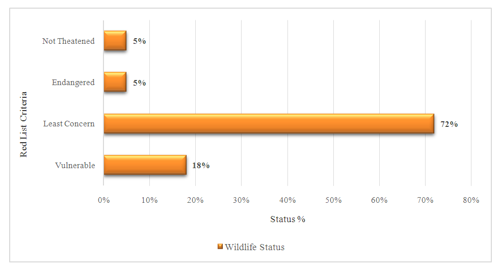 | Figure 4. Wildlife Criteria of Lawachara National Park |
3.3. Degree of Threats to National Parks
- Protected areas consists of national parks, wildlife sanctuaries, nature reserves and relevant other areas. The total number of protected area records in the December 2016 release of the World Database on Protected Areas (WDPA) is 232,128 comprising of 213,328 polygons and 18,800 points (UNEP-WCMC, 2016).Degree of pressures and threats increase day by day on Lawachara National Park (IPAC, 2012), as shown in Figure 5, with compared different parameters towards protected areas in Bangladesh, such as, hunting, illegal logging, access road use inside the park with road transport and railway route.
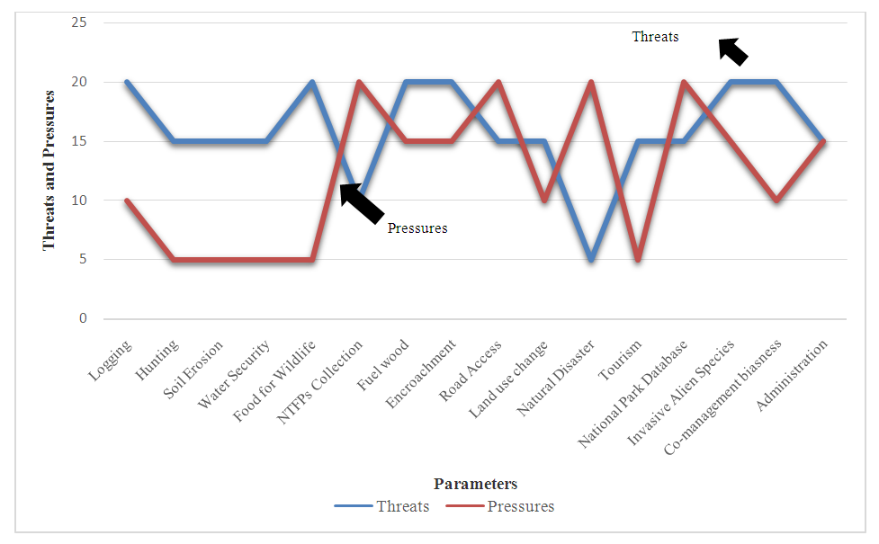 | Figure 5. Degree of Pressures and threats on Lawachara National Park |
3.4. Biodiversity Networks with Treaties/Agreements
- Bangladesh is a ratified as well as signatory state party to selected regional and global conventions. These conventions provided environmental conservation policy instrument for the protection of National Parks biodiversity. These conventions are (a) CBD, (b) CITES. (c) World Cultural and Natural Heritage (MoEF, 2015); (BRC, 2016); (CITES, 2016); (APAP, 2016), as shown in Table 3. These treaties and conventions create new collaboration with national, regional and global agreement with organizations for biodiversity conservation and protection.
|
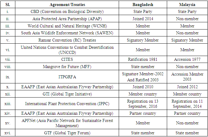
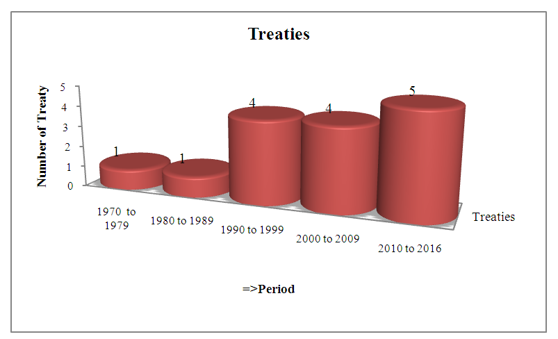 | Figure 6. Biodiversity related regional and international treaties ratified by Bangladesh |
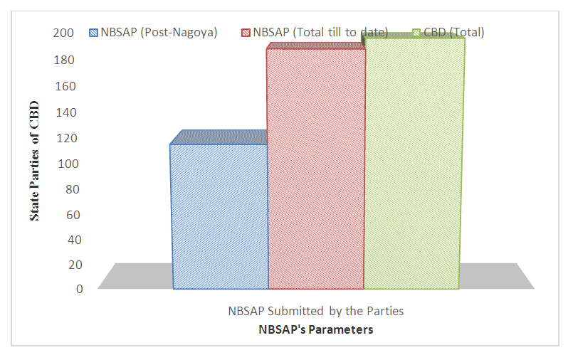 | Figure 7. NBSAP Report submitted status by State Parties to CBD |
3.5. Building Biodiversity Information Systems
- Biodiversity Information Systems (BIS) is a database that contains all information related to biodiversity for collection, processing, dissemination, storage, export of information for assessment and decision making. BIS links to World Database on Protected Areas (WDPA), Biodiversity Clearing House Mechanism (BCHM) and Integrated Online National Database (IONDB) due to active geospatial applications. To develop a biodiversity information system with multi-relationships as shown in Figure 8, researchers can develop biodiversity information systems using MS Access tools.
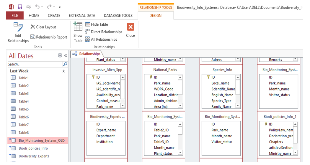 | Figure 8. Multi-relationships for Biodiversity Information Systems |
 | Figure 9. Database tools used for report wizard of Biodiversity Information system |
3.6. BIS Database Report
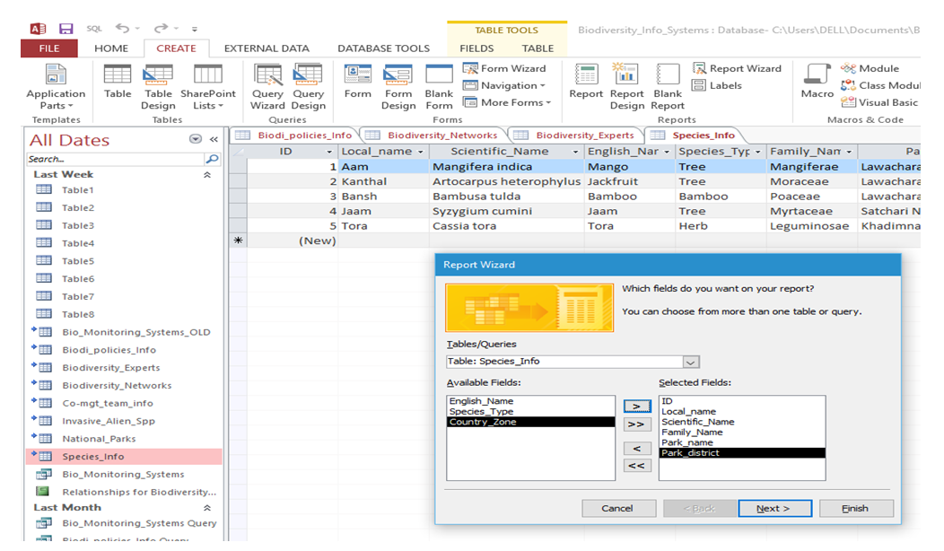
- For database report, the researcher used here report wizard options, as shown in Figure 10 on database tools indicating wizard interface and print report of Lawachara National Park biodiversity within a short time to make decisions. Biodiversity Information System Database report system can augment for sending national reports to convention on Biological Diversity (CBD) within the stipulated time. For these purposes, the database users can develop entity relationship diagram (ERD), then report wizard through application software, like MS Access 2021, Visual Basic, or Oracle programming. Here the study used MS Access 2021.
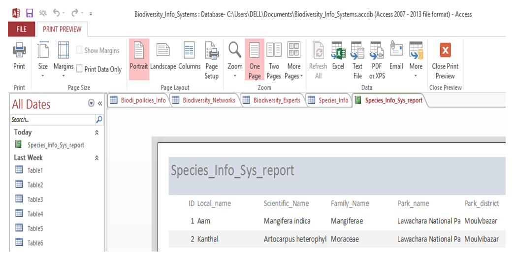 | Figure 10. Database Report on Species Information Systems (SIS) |
3.7. Using Integrated Online Biodiversity Conservation Database
- Biodiversity conservation databases created to expect where study determinations may be directed, to be reprocessed as alternates for complete assessments of species in a study of biological diversity at a county scale, and to envisage conceivable effects of conservational vicissitudes (CBD, 2016; Aspinall, 1995). The BIS consists of some essential components for integrated database as shown in Figure 11. Integrated Biological Diversity Information Systems (IBDIS), is a central database which (is) interlinked with MoEF including BFD and DoE. It is the application of information systems that helps to improve management, operation, monitoring, sharing, detection, assessment and enquiry of the biodiversity. It forms (is formed) on the basis of species taxonomic, systematic and biological evidence warehoused in digital conservation manner. The database stores information on visitor’s catalog, vegetation mapping with the connection of Regional Navigation Satellite System (RNSS) interlinked with Space Research Remote Sensing Organization (SPARRSO). Therefore, other stakeholders can utilize the IBDIS according to their requirements as indicated in BIS database. A specific value of IBDIS is to identify species status, site quality, mapping segment and geographic location, that could be utilized as bio-catalysts of ecological based management and provide early cautionary of changes in National Park areas.
 | Figure 11. Components of Integrated Online Biodiversity Database (ITIS, 2017) |
 | Figure 12. Biological Diversity Information Systems at Lawachara National Park |
3.8. Biodiversity Database Users
- Administrative users are mainly top management executive staff, decision-maker, and network security manager, monitoring officer and Chief Parton / Adviser. This database interlinked with World Database on Protected Areas (WDPA), Red List Database, Species Information Systems Database, and Taxonomic Information Systems Database, Global Invasive Alien Species Database, Biodiversity–Clearing House Mechanism Database, CBD– State Parties Database, Biodiversity related National and Global Experts Database, Global Navigation Geospatial Database, Global Ex–situ Database including Global User Geographic Positioning Systems, as shown in Figure 13.
 | Figure 13. Different users of national biodiversity database |
3.9. Security of BDIS Database
- All data base need proper safety for its effective and efficient operations. But in Bangladesh about 53% respondents were of the opinion that less secure as a whole that deals virus, spam, cookie, malware and so on with the obsolete technology and information systems, compared to only 7% who were of the opinion that BIS database more secure as shown in Figure 14.
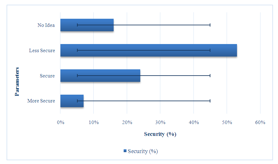 | Figure 14. Security Status of National Biodiversity Database |
3.9.1. Stakeholders’ Perception for Biodiversity Information
- Biodiversity is important in our life. However, we (ONE) cannot perform a single task without its information. The importance of biodiversity information is essential to the respondents in the study areas are shown in Figure 15.
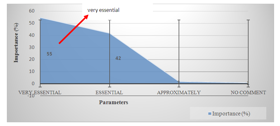 | Figure 15. Importance of Biodiversity Information |
3.9.2. Perception on Biodiversity Information Systems
- BDIS shows a vital part in researches on national park biodiversity protection particularly in the arena of natural resources and digital technology that deals with the impact of activities on eco-systems. In Figure 16, it can be seen that about 58 respondents who are academic staff performed utilizing BDIS for their research activities sturdily for sustainable protected area management, compared 2 Postgraduate/Post Doctorate for their research.
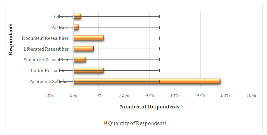 | Figure 16. Research Role Play among Stakeholders on Biodiversity Information Systems |
3.9.3. Biodiversity Knowledge Management Systems
- Knowledge of Respondents in Biodiversity Information Systems is imperative, because, with the knowledge on BDIS, they need to know the worth of relevant database that deals with the input, processing, and output with the technology and information systems. In Figure 17, that the findings revealed that about 43% of respondents have simple knowledge for more informed research knowledge to maintain strappingly for sustainable protected area management as compared to 11% of respondents who claimed that are ‘more informed’ of the BDIS.
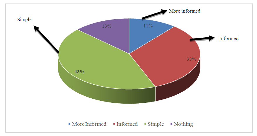 | Figure 17. Knowledge of Respondents in Biological Diversity Information Systems (BDIS) |
3.10. Assessment of Geospatial Technology for Biodiversity Conservation
- There are several applications of geospatial technology for biodiversity conservation, which illustrated successively. This geospatial technology enhances the LNP with digital conservation with dissemination of biodiversity information towards national as well as global perspectives.
3.10.1. Geodata Centric Conservation Mode
- Geospatial database technology can apply for digital conservation. NASA’s multi-platform Earth Observation System generates over one terabyte of geospatially referenced raster data per day (Shekhar and Chawla, 2003). Geodata is the spatial dataset collected with geodata centric mode. The Goedata centric mode consists of (i) Geodata Sensor centre, (ii) Geodata receiving station, (iii) Geodata processing centre, (iv) Geodata distribution centre, and (v) Geodata application centre, as shown in Figure 18. The study collected the geodata with active application of such datasets towards Lawachara National Park to inform the existing biodiversity status. The study illustrated geodata including existing agricultural lands, encroached agricultural lands, encroached fallow lands, normal fallow lands, and forested areas, and Rubber gardens, community settlements, Tea estate, and water bodies (CEGIS-WARPO, 2012). Geospatial systems (is) determined to solve common problems in spatial computing have been tailored with a great deal of achievement to geospatial computing.
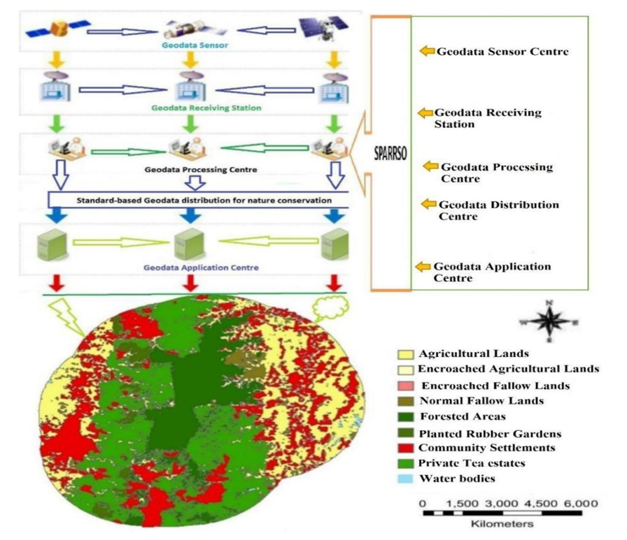 | Figure 18. Geodata centric biodiversity conservation mode at Lawachara National Park |
3.10.2. Geospatial Application on Ecological Integrity
- Throughout the country, the wetlands are decreasing, due mainly to anthropogenic activities like unplanned expansion of housing and settlements, industrial installations and construction of road networks with relevant parameters, as shown in Figure 19. The study represented on agriculture, vegetation and fallow land with ecological integrity components, particularly Lawachara National Park Biodiversity Conservation. The study suggested requiring monitoring with geospatial application towards Lawachara National Park diversity status.
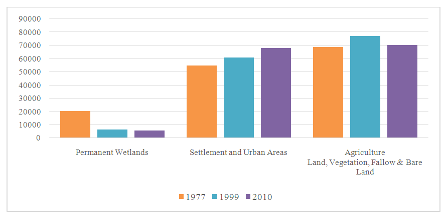 | Figure 19. Changes in Land classes during the period 1977 to 2010 in Bangladesh |
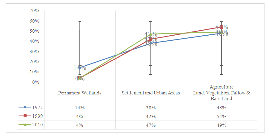 | Figure 20. Changes in Land classes (%) during the period 1977 to 2010 in Bangladesh |
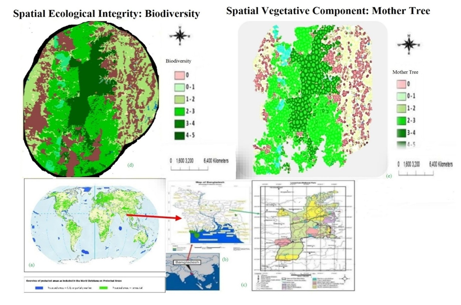 | Figure 21. Spatial Ecological Integrity on biodiversity and spatial vegetative component |
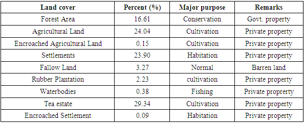
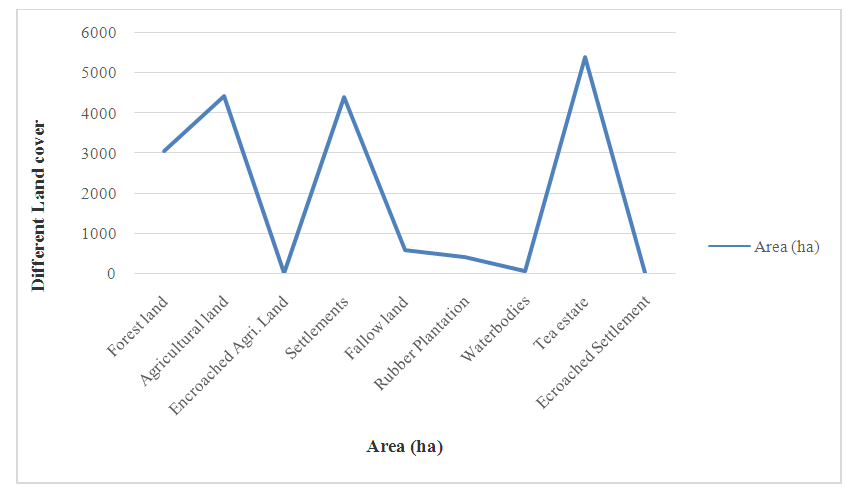
3.10.3. Land Use/ Land Cover (LULC) Status
- Land degradation and land use change are the major barriers at Lawachara National Park for loss of biodiversity. The research illustrates the different types of land cover surrounding the Lawachara National Park showed in Table 4 including using percentage, major purposes and remarks. The study observed that 16.61% only forested area for conservation purposes by government, but the rest of area, 83.39% used by other purposes, which will affect on ecological pressure towards Lawachara National Park.
|
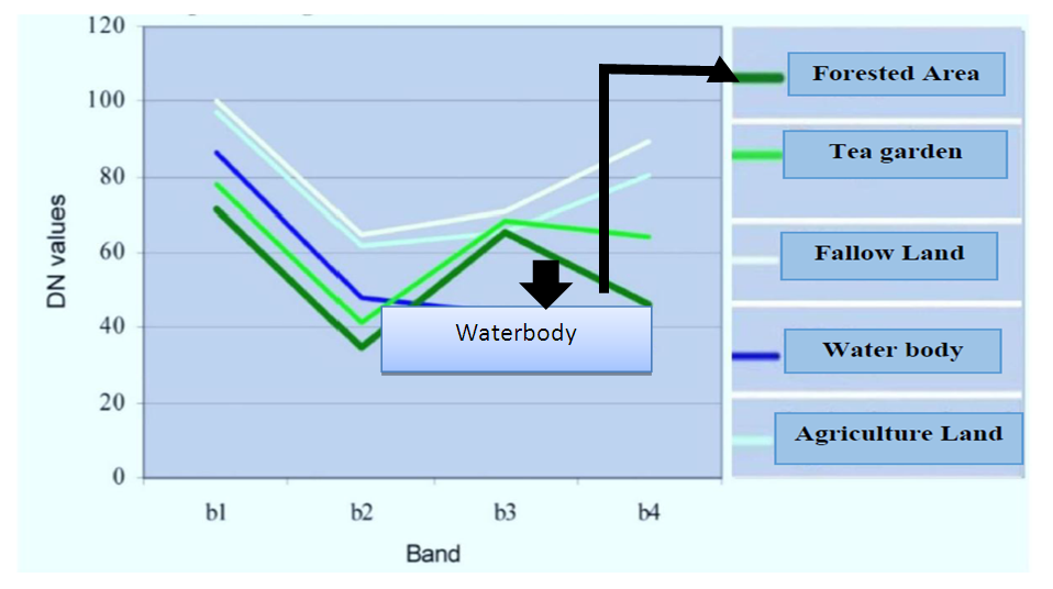 | Figure 22. Spectral signature of different land use/Land covers at LNP |
 | Figure 23. Land use/ Land cover adjacent area of Lawachara National Park |
3.11. Biodiversity Information- Clearing House Mechanism
- Biodiversity Information– Clearing House Mechanism is the newly formed online global as well as national database, connected with State Parties and CBD. This database is a bigdata portal with different parameters related to biodiversity.
3.11.1. Different Parameters for Developing CHM Database
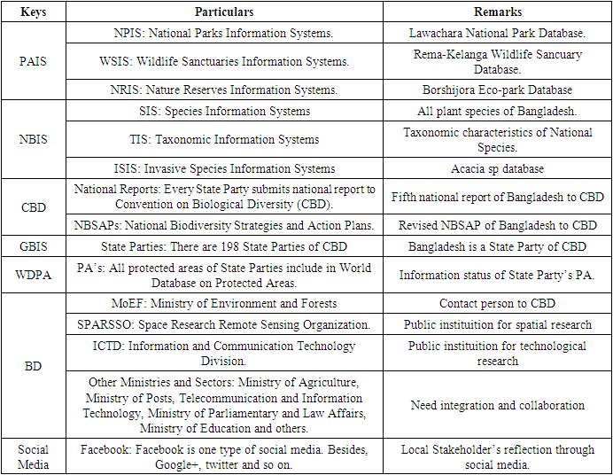
- Biodiversity Information-Clearing House Mechanism interlinks with Integrated Online Biodiversity Information Systems (IOBIS). National biodiversity information — clearing house mechanism is the update information system for digital conservation, information sharing, update, collaboration, online monitoring and technology transfer among State parties and relevant organisations. Meanwhile, the policy-makers take initiative for update law, policy and strategic plan on sustainable conservation of biodiversity. This IOBIS database will open the global gateway for digital conservation among state parties and relevant national, regional and global organizations. This clearing house mechanism is helpful to sending national report to Convention on Biological Diversity (CBD), which creates evaluation status and decision-making. The IOBIS constitutes with different parameters and particulars as shown in Table 5.
|
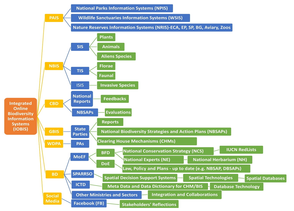 | Figure 24. Structure of Integrated Online Biodiversity Information Systems |
3.11.2. Assessment of State Parties Biodiversity Clearing House Websites
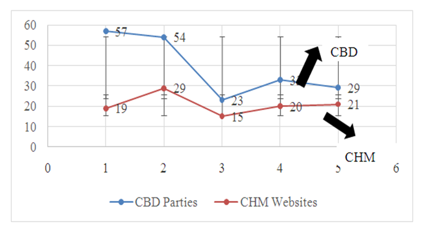
- From the study, it is identified that Bangladesh has not developed Biodiversity Clearing House Mechanism (BCHM) till to date, among the 196 CBD’s state parties. However, all state parties did not (refrain from) developing their national clearing house mechanism websites. Here, the research mentioned few CHM websites to compare with CBD and State Parties through Figure 25, with relevant parameters. There are 57 state party of CBD in Asia and the Pacific but only 19 States developed CHM websites. The study suggests that Government of Bangladesh need to develop CHM website within the stipulated time.
 | Figure 25. Clearing House Mechanism websites developed by some State Parties |
3.11.3. Status of Clearing House National Focal Point
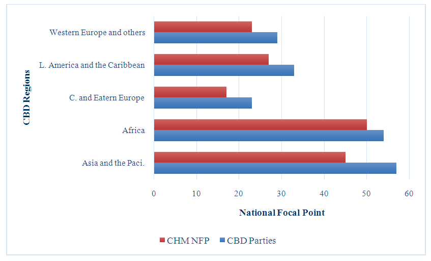
- National Focal Points (NFP) are the most important contact purpose between CBD and State Party. However, some State Parties have no national focal point till to date, as shown in Figure 26 including Asia and the Pacific National Focal Point Status and each other. The study represented the 57 CBD State party in Asia and the Pacific but CHM NFP is only 45. The Study suggests that the CHM-NFP is essential for secured communication between CBD and other State parties. NFP of Bangladesh needs to use secured communication with CBD and relevant other state parties.
 | Figure 26. Status of CHM National Focal Points |
3.11.4. Status of CBD State Parties Clearing House Mailboxes
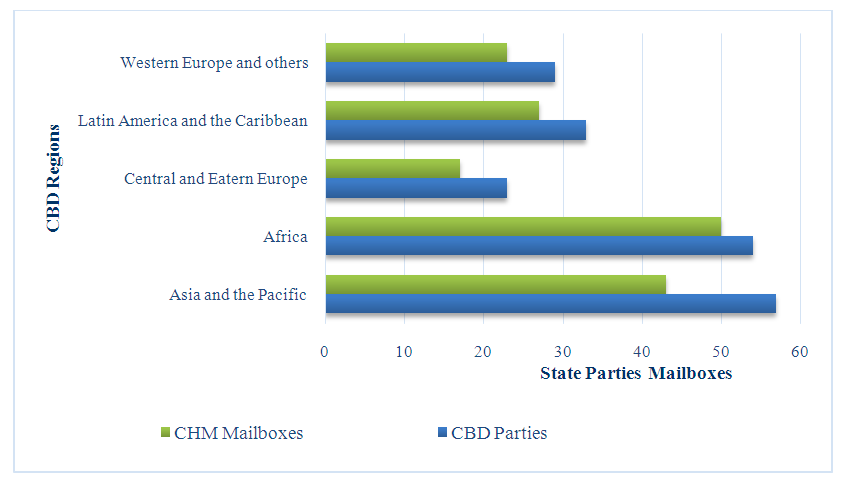
- In modern era, communication is the quick connection among each other. CBD and State Parties are the connector partners through mailboxes. But some countries have no CHM mailboxes till to date as shown in Figure 27 including different regions representing the informational instruments in connection with Lawachara National Park Digital Biodiversity Conservation in Bangladesh.
 | Figure 27. Status of CBD State Parties Clearing House Mailboxes |
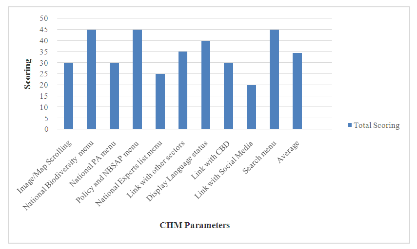
3.11.5. Observation on State Parties’ Clearing House Websites Menus
- State Parties CHM websites’ menu enhance quick display and follow up the visitors’ reflections on the policy, documents, present status of national biodiversity, as shown in Figure 28 including update NBSAP, national report to CBD, link with other sectors, CBD and social media, and so on. However, some webpages are not attractive to visitors as a whole. The average scoring is 34.5 out of 50. The highest scoring is 45 in the parameters of national biodiversity menu, policy and search menu, but lowest 20 linking with social media. The study suggests that quick display webpage attracts to the visitors and users. Government of Bangladesh needs to develop the quick display webpage with high scoring requirements of CBD.
 | Figure 28. Status of CBD State Parties Clearing House Websites (Source: Field Data) |
3.12. The Idea of Biodiversity Clearing House Mechanism
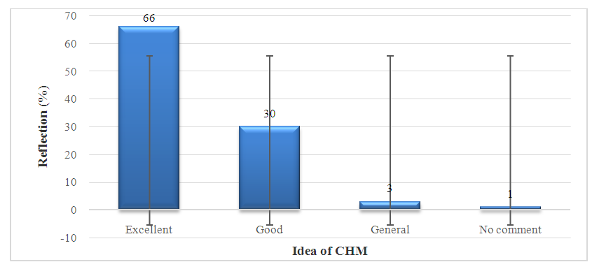
- Biodiversity Clearing House Mechanism (BCHM) is the priority of biodiversity information dissemination to aware digital conservation for the rationalized generations. It connects the whole National Park databases, WDPA and displays the update news for sharing, augmenting, digitalizing, updating and reporting in connection with State Party’s National Biodiversity status. Till to date, Bangladesh has not developed the national biodiversity clearing house mechanism. Government of Bangladesh should take initiatives on this task, because it is essential for digital conservation and information exchange according to State Party of CBD. About most of 66% respondents expressed their opinions on biodiversity clearing house mechanism for national biodiversity database, as shown in Figure 29. The study suggests that this idea will reflect to the Government of Bangladesh towards development of national CHM.
 | Figure 29. The Idea of Biodiversity CHM for national database |
4. Discussion
4.1. Innovative Information Systems for Biodiversity Conservation
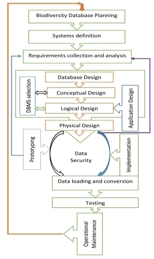
- Biodiversity is the multiplicity and changeability of living flora then fauna in sphere. It is a multifaceted word, which indicates its specific objective as the changeability amongst alive creatures starting entirely home environment comprising, and so on, land-dwelling, sea as well as additional river ecologies and the environmental multiplexes of their apart; this embraces variety surrounded by species (Soulé and Sanjayan, 1998), concerning species and of environments (CBD, 1992). Human-beings live in the age of information with modernized technology (Kinuthia, 2008), which enhances the production, storage, and sharing of information with rules and regulations to make a significant facet of economic, cultural and scientific affairs at scales from local to global (Michael et al., 2006) biodiversity information. So, all human–beings are experiencing a digital revolution with an information explosion to become individuals highly susceptible to information anxiety or overload (Biggs, 1989; Holtham and Courtney, 1999). For this, information systems need for national park biodiversity conservation (Johnson, 2007) with database planning, designing, prototyping, testing and application including database security, as shown in Figure 30 with biodiversity database management system selection.
 | Figure 30. Biodiversity Database Planning and Prototyping (Coronel et al., 2013a) |
4.2. Biodiversity Information Systems
- Biodiversity information systems (BIS) is a dataset of biodiversity. The BIS can be used different purposes, such as: (i) monitoring (Reyers and McGeoch, 2007),(ii) bioregional planning (Smith and Wolfson, 2004), (iii) identifying and categorizing threatened species (Tweddle et al., 2009),(iv) understanding the impacts of global change on biodiversity (Coetzer et al., 2012; Skelton and Coetzer, 2011; Cherry, 2009; Skelton et al., 1995); (v) developing mitigation strategies (Carlos et al., 2010); (vi) informing sustainable harvesting programs; control of alien, invasive species (Foxcroft et al., 2009), (vii) ecological niche modeling (Phillips et al., 2006), (viii) disease vectors; environmental impact assessments (Coetzer et al., 2012) and (ix) decision making on policy status of biodiversity protection. (x) Protected Area Management Control Unit (Miah et al., 2021).Moreover, Researchers and scientists are being confronted to appropriate information systems from large scale level to national level for managing and embracing conservational justifiability (Watson et al, 2010). The system related with species conservation in general, existing environmental instrument assessment as well as scrutinizing through suitable options of correctness for conserving activities (Krigas et al., 2012). In National Park areas management, information technology for biodiversity includes biodiversity databanks, using spatial technologies, like GIS, GPS, RS and GNSS (Michael et al., 2006; RTC, 2016) in connection with spatial applications. Information Systems provide extents of evidence on a wide-ranging (Boddy et al., 2016) level for the implementation both as data and software uses conservation biology (Stein, 2008) to promote decision- making and disseminating through an administration (Laudon and Laudon, 2010). The BIS interlinked with taxonomic information systems (ITIS, 2017) and species information systems, which provides integrated information management of biodiversity.
4.3. Evolution of Biodiversity Database Models
- The expedition for better biodiversity data management had navigated to numerous models that seek to resolve the earlier model’s decisive inadequacies (He and Hubbell, 2011) and to furnish solutions to ever-advancing conservation data management requirements (Bisby, 2000). These models represent biodiversity information as to what a database is, what it should do, the modes of structures (Soulé and Wilcox, 1980) that should apply, and the technology that would be operated to implement these formations. The general data models show in thereabouts chronological order, which traces the evolution (Adams, 2004) of the major biodiversity data models (Coronel et al., 2013b). The biodiversity data models are (i) File system, (ii) Hierarchical and network, (iii) Relational database, (iv) Object-oriented, Object/relational (O/R), (v) XML, Hybrid DBMS, (vi) Key-value store, Column store, for example: Simple DB (Amazon), BigTable (Google), Cassandra (Apache) (Coronel et al., 2013b).
4.4. World Database on Protected Areas and Biodiversity
- Every national park connected with global database (for example—WDPA), which is a comprehensive protected areas’ network databank (IUCN and UNEP, 2011). It provides information on national parks (IUCN, 1993), wildlife sanctuaries and related areas status (Coad et al., 2015) of existing State Parties. These protected areas include on national park, wildlife sanctuary, nature reserve (terrestrial and marine) with relevant reports (UNEP-WCMC, 2017). According to WDPA (2017) total national parks of Bangladesh put its ID in the world database in protected area (WDPA), particularly national parks, located district and gazette date. The WDPA uses for biodiversity information from the different state parties, institutions, researchers, developers, network specialist, decision-makers and stakeholders. It creates new global network (UNEP, 2013) on biodiversity information systems as well as protected areas (PA-CBD, 2016) information systems interlinked with clearing house mechanism. But some developing countries cannot develop their own clearing house mechanisms or relevant databases which connected with WDPA due to lack of technical, security or pertinent problems.
4.5. National Park Biodiversity Database
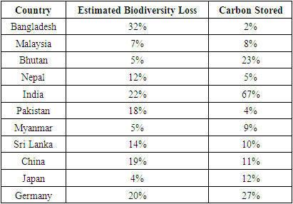
- Challenges to conserve biodiversity (Rands et al., 2010) augment towards national park except network technology. Database threat is the circumstances or experience indicating deliberate or unplanned, which undesirably disturbs a database structure as well as subsequently to the administration (Connolly et al., 1997b). The estimated losses of biodiversity on protected areas of some countries illustrated in the Table 6. It may be represented by individual, task or situation, which is expected to convey maltreatment to national park administration including hardware damage, software or data/information spoil, or breaking of customer buoyancy.
|
4.6. Spatial Systems for Biodiversity Conservation
- Dynamic, on-going research in the often-overlapping fields of geographic information systems (GIS), spatial data structures (Fonseca, 2008) and algorithms, spatial databases, and computer graphics has provided geospatial applications with a rich set of techniques, general data structures, and algorithms (Samet, 1989); (Samet, 1990); (Shekhar et al., 1999); (Rigaux and Voisard, 2002); (Shekhar and Chawla, 2003). According to Ravan (2010), the Group Decision Support Systems (GDSS) ensures a widespread observation as the advancement of digital conservation technology, for example—WDPA, Spatial Database. These conservation technologies presented with update computerized technologies that is implemented to make the GDSS in various national parks’ biodiversity assessment options. The biodiversity information with Clearing House Mechanisms (CHMs) is an application of online spatial database systems. Ecologists and policy-makers have been elaborate in producing vast biodiversity related databases on different parameters, such as (i) the species, (ii) species status, (iii) species habitats, (iv) socioeconomic impacts, and (v) species monitoring (Vreugdenhil et al., 2003) and so on to compare on general support system to the spatial support system (Ravan, 2010) to know the present status for national biodiversity decision-making.
4.7. Digital Technology for Conservation of Biodiversity
- Digital conservation refers to several types of dimensions (Arts et al., 2015), which enhance the national park conservation management, such as: (i) participatory governance, (ii) data on nature, (iii) data on people, (iv) data integration and analysis, (v) communication and experience, and (vi) data security and feedback (Wade, 2006). These dimensions enhance to digital technology for conservation of biodiversity. Advanced digital technology enhances to the conservation of biodiversity through data collection (Peri et al., 2011) research gate, surveying, information sharing, technology transfer and growth of update law, policy and legislation (Pullin et al., 2013). But there are also some barriers on system security, authentication, update information and update software installations (Arts et al., 2015), lack of digital conservation apps (van der Wal and Arts, 2015) and misuse modern technology towards wildlife (Kays et al., 2011). Digital conservation is the broad range of development at the interface of digital technology and nature conservation (van der Wal and Arts, 2015).
4.8. Biodiversity Clearing House Mechanisms
- The word ‘clearing-house’ originates initially starting the arena of Investment, wherever it represents a central body that settles indebtedness between various financial institutions. In connection with the agreement, it was originally arranged to agree up a support providing evidence on biological diversity (CHM, 2010). Hereafter, moderately the existence massive data-set, the clearing house mechanism (CHM) is an evidence-based network (WCMC, 2010) completed up of automated and general electronic media (GIZ, 2001). Every contracting member of CBD committed to develop the CHM for scientific information exchange (Roberts, 2007) according to the Article 18.3 (CBD, 1992). It supports circumvent repetition of exertion, stimulates the sharing of network domain as well as facilitates communicated goals to be accomplished corresponding swiftly. In order to be able to implement the CBD, contracting states, non-governmental organizations, and all the other bodies supporting the convention need a great deal of information and knowledge. Much of these information and knowledge is already obtainable wherever in the earth including the system of biological diversity assessments, analysis outcomes, records on supportable practice, related legal status, statute, and controlling approaches for national park zones with specific strategies for structures, professional data-sets, national reports, conference and trained-up sequences. Without CHM support, it deals with time consuming, lack of transparency as well as lack of quick connections for operation. The CHM implies regionalized need-based structures which support policymaking and advances management with National Focal Point of contracting Government. Ecosystem extent and its dynamics are monitored using remotely sensed datasets as landcover is used as a proxy (Geremew et al., 2022). Continuous large-scale mapping of forest canopy height is very important for forest carbon content estimation, reporting, forest degradation, landslide analysis and accordingly biodiversity conservation (Sothe et al., 2022), (Guerra-Hernández et al., 2022).
5. Develop National Biodiversity Clearing House Mechanism Model
- A planned stronger and operative clearing house mechanism developed new multi-channels of communication globally, such as (a) support development of environmental awareness, (b) creating associations to the on-going nature conservation activities, (c) Consciousness levitation, (d) biodiversity information broadcasting. The study illustrates the participation of all the sponsors for necessary actions of national government and non-governmental organizations, private industries, local community leaders, Network Specialists, ICT Company, Park Manager, Team Leader of Co-Management Committee, Indigenous community Leader, Academician, Biodiversity Specialist, Botanists, Zoologists, Researchers, Environmentalists and Lawyers, Local Government Leaders, Policy-makers and effective other stakeholders. The biodiversity clearing house mechanism creates new effort to the national conservation awareness and disseminating worldwide through online connection as well as interlinked with CBD and other state parties (Figure 31). This model will be enhanced by the state party for developing of national biodiversity clearing house mechanism, which fulfils the requirements of CBD’s CHM. For example: National Plant Species Database, Wildlife Database, National Park Database and so on. These are interlinked with clearing house mechanism either state party as well as Convention on Biological Diversity. This model also can enhance national reporting to CBD. The assessment of the study that it is connected with world database on protected area, Asian protected area network, CBD state parties’ networks, IUCN Red List Database, Global Taxonomic Database, Conservation International Database, Taxonomic Database Working Group and digital conservation related new network database. The BCHM is suitable for information dissemination and collection by the researchers, academia, scientist, botanists, zoologists, biodiversity specialist, taxonomists, environmentalists, Lawyers, Environmental educationists, Digital conservationists and natural science philanthropists with development of biodiversity.
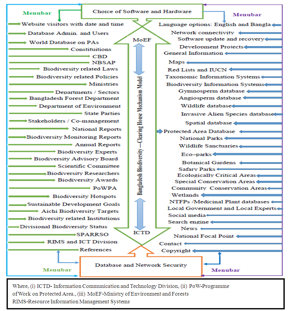 | Figure 31. Development Model for Biodiversity Clearing House Mechanism |
5.1. Establishment of National Park Database Security Systems
- The national park database security is to safeguard the national park information contradiction of coercions using both practical and governmental controls. Plant and Wildlife Security attentions do not only relate to the database; that is, the data itself. The biodiversity security control unit is based on computer and non-computer systems. Computer-based controls are (i) permission, (ii) interpretations, (iii) encryption, (iv) accuracy (v) check-pointing, (vi) journaling, (vii) backing-up, and (viii) connected actions. Gaps of retreat could disturb additional portions of the nature conservation system as well as relevant biodiversity information sharing, indexing, retreating and uploading data, as shown in Figure 32. Non-computer-based control for national park database is the general database environment in combination with the network-based security controls with national park biodiversity such as species, monitoring, commentary, strategies, contracts and other managerial controls.
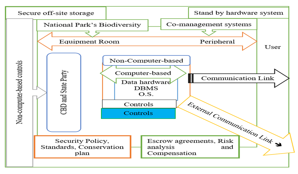 | Figure 32. National Park Database Security Systems |
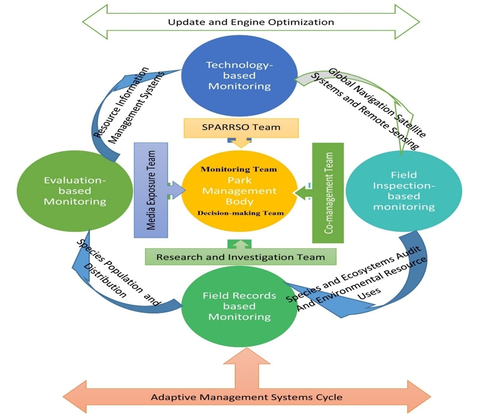
5.2. Setting National Biodiversity Monitoring Information Systems
- Biodiversity monitoring information system enhances in emerging national park biodiversity portfolio and structures to take up monitoring options in biodiversity (BLI, 2006) through reporting the present conditions and changes as shown in Figure 33.
 | Figure 33. Biodiversity Monitoring Information Systems |
6. Conclusions
- The study had assessed as alarming on the biodiversity information systems in geospatial applications for protected areas in Bangladesh. The findings of this study clearly indicate that traditional policy, illegal logging, wildlife poaching, NTFPs collection, parkland encroachment, excessive invasive alien species and no national park database in connection with biodiversity clearing house mechanisms are important sources for loss of biodiversity at LNP. Biodiversity Strategy and Action Plan for state parties, and national park database networks including clearing house mechanisms tends to bring new scenarios and dimensions to novel attitudes in biodiversity information systems, growth of national park analysis, predictive modelling, and synthesis, geodata exchange and visualization of biodiversity information. This reflects the importance that the relevant national and global decisions that are placed on the conservation of biodiversity and the ecosystem services they provide.
7. Declaration
- FundingThis research work is a part of PhD Thesis, which was funded by the Zamalah Postgraduate Scholarship of UNIMAS, Malaysia and also sponsored by the Information and Communication Technology Division, Ministry of Posts, Telecommunications and Information Technology, Government of People’s Republic of Bangladesh. The funders had no role in the design of the research, in data collection, analyses or final interpretation of data, in the writings of the manuscript, or in the decision to publish the findings.Data AvailabilityThe data being used to support the findings of this research work are available from the corresponding author upon request. Competing InterestsThe authors declare no potential conflict of interests in this research work.
ACKNOWLEDGEMENTS
- The authors acknowledged the authority of Universiti of Malaysia Sarawak (UNIMAS), Malaysia for providing the Zamalah Postgraduate Scholarship for the completion of PhD degree. The authors are also grateful to the authority of the Information and Communication Technology Division, Ministry of Posts, Telecommunications and Information Technology, Government of People’s Republic of Bangladesh, for PhD Fellowship during the higher study in Malaysia. The authors acknowledged the authority of North East Medical College & Hospital (NEMCH), affiliated with Sylhet Medical University at Sylhet in Bangladesh for kind support. The authors also acknowledged the higher authority of Missouri Botanical Garden Open Conference Systems, TDWG 2016 ANNUAL CONFERENCE for providing oral presentation award and published abstract at https://mbgocs.mobot.org/index.php/tdwg/tdwg2016/paper/view/973.