-
Paper Information
- Paper Submission
-
Journal Information
- About This Journal
- Editorial Board
- Current Issue
- Archive
- Author Guidelines
- Contact Us
American Journal of Geographic Information System
p-ISSN: 2163-1131 e-ISSN: 2163-114X
2019; 8(4): 158-190
doi:10.5923/j.ajgis.20190804.02

Management of the Effects of Land Use Changes on Urban Infrastructure Capacity: A Case Study of Ruaka Town, Kiambu County, Kenya
 Abstract
 Reference
 Full-Text PDF
 Full-text HTML
Dennis Abuya, Maurice Oyugi, Edwin Oyaro
Department of Architecture and Building Science-School of the Built Environment, University of Nairobi, State-House Road, Nairobi, Kenya
Correspondence to: Dennis Abuya, Department of Architecture and Building Science-School of the Built Environment, University of Nairobi, State-House Road, Nairobi, Kenya.
| Email: |  |
Copyright © 2019 The Author(s). Published by Scientific & Academic Publishing.
This work is licensed under the Creative Commons Attribution International License (CC BY).
http://creativecommons.org/licenses/by/4.0/

Land use change is a major driver to the effects of climate change and other socio-economic and environmental challenges, a major challenge policy makers, planners and urban managers grapple with. Ruaka town is no exception as it faces high rapid land use change with myriad challenges on the management of the effects on urban infrastructure and aggravated by inadequate inter-agencies, coordination and collaboration. The study is an investigation of the effects of land use changes on urban infrastructure (roads, water supply, and wastewater infrastructure). It seeks to answer the drivers of land use changes and document the spatial-temporal land use changes between the years 1988 to 2019, establish their effects on infrastructure. The study establishes decline in vegetation and agriculture and rise in built -up areas which is partially contributed by urbanization and population growth in the area with major land fragmentations and land use conversions. The findings reveal encroachment of development to vegetation and riparian reserves which expose the human population to disasters and calamities in cases of climate change. Lack of approved planning policy has encouraged massive land use changes due to the ad hoc nature of planning using the development control tools which are not documented. The key drivers of land use changes deduced were good accessibility of the area, land speculation for investments, high returns from investments, demand for housing and accommodation and high population growth. The adverse effects on urban infrastructure includes pollution and contamination of water sources, traffic congestion, use of unconventional onsite waste management practices such as pit latrines and septic tanks for waste water management. The study concluded by evolving a management strategy to unravel the challenges through promotion of a sustainable and resilient urban infrastructure. The strategies emphasize on the technical, social, economic, environmental and jurisdictional dimensions.
Keywords: County Government, Development, Land Cover, Land Use, Land, Sustainable Development, Urban Infrastructure and Urban Sprawl
Cite this paper: Dennis Abuya, Maurice Oyugi, Edwin Oyaro, Management of the Effects of Land Use Changes on Urban Infrastructure Capacity: A Case Study of Ruaka Town, Kiambu County, Kenya, American Journal of Geographic Information System, Vol. 8 No. 4, 2019, pp. 158-190. doi: 10.5923/j.ajgis.20190804.02.
Article Outline
1. Introduction
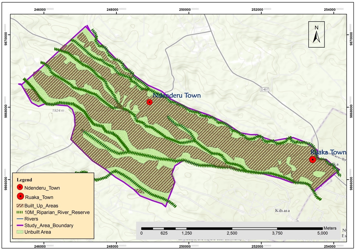
- Urbanization is a key factor to land use change, mainly through its transformative effects on rural areas into urban built-up areas (Lambin et al, 2001) [38]. It is estimated that more than half (55%) of the world population lived in urban areas in the year 2018 and it is projected that 60% and 68% of the world population will be living in urban areas by the year 2030 and 2050 respectively but with a high concentration in Asia and Africa (UN, 2018) [64]. The rapid pace of urbanization has brought about rapid land use change and land cover conversions in Africa and Asia as occasioned by the fact that most parts of Africa and Asia are still predominantly rural as opposed to developed countries. Based on the current trends, the urban land cover will increase by 1.2 million Km2 by the year 2030 (UNDP, 2016) [62]. While urban areas are experiencing unprecedented land use changes, it’s evident that a majority of such centers in Kenya are unprepared for urban growth and are ill-equipped to manage the resultant effects of land use changes on urban infrastructure. The strain caused by rapid urbanization and land use changes has exacerbated problems with the safety of urban infrastructure and distribution systems creating a capacity concern as evidenced by inadequate design; construction and inadequacy in its management. Policymakers equally face major challenges of handling such unprecedented urban growth because of inadequate capacity, lack of guiding policy and institutional framework to guide in the administration and development control. Equally, the weak capacity of the county governments to enforce development control has worsened the situation. Ruaka Town in Kiambu County formerly a predominantly rural agricultural center has over the years expanded leading to land subdivisions and conversions from agricultural to residential and commercial users without a guiding framework for the transformation. This has consequently led to traffic congestion, intermittent water supply, poor liquid and solid waste management, high cases of insecurity and high disease prevalence among others. The solution to these challenges in most of the urban centres seems to be ad hoc and reactionary rather than proactive measures being put in place. Over the past years, there has been planning efforts to have all urban centres within Kiambu County have physical development plans prepared but this has not been implemented. This has been occasioned by inadequate coordination between institutions, lack of technical, financial capacity and political goodwill as well as negative reactions of local communities based upon previous negative experiences and numerous unmet promises leading to lack of trust in such government operations (Kenawy et al. 2017) [34]. This has led to the haphazard urban growth which raises questions on the capacity of the institutions and management strategies they use in containing these catastrophes. The County Government of Kiambu has not lived up to the expectations of controlling urban developments. This has led to uncontrolled developments and land use changes which has resulted in negative effects on urban infrastructure. Due to the nature of densification without commensurate urban infrastructure expansion, there has been strain on the access roads which were footpaths to agricultural farms and single dwelling units, contamination of water from sunk boreholes adjacent to neighboring sanitation facilities such as pit latrines and leakages from septic tanks as the area does not have a conventional sewerage system. This has been attributed to a lack of effective management policy in place, inadequate financial support and technical capacity of the County Government to deal with the uncontrolled urban developments. Against this backdrop, large knowledge gaps exist in containing the effects of land use changes (LUC) on urban infrastructure. The evaluation brings forward limitations of the County Government to manage the effects of urban LUC on urban infrastructure yet this is imperative for sustainable urban development. Despite previous similar studies, a gap has been identified as previous studies never opted for management strategies to contain the effects of LUC on urban infrastructure with land use change-resilient urban infrastructure systems. The study, therefore, fills this gap and culminates into providing answers and recommendations on promoting land use change-resilient urban infrastructure with sustainable growth.The goal of this study was to investigate the effects of land use changes on urban infrastructure with the aim of promoting land use change-resilient urban infrastructure with sustainable urban development. The following objectives guided the study;i. To document the land use changes and establish their drivers in Ruaka Town, Kiambu.ii. To establish the effects of land use changes on existing roads, water, and wastewater infrastructure capacity in Ruaka Town, Kiambu.iii. To evolve a management strategy to unravel the effects of land use changes on roads, water and waste water infrastructure capacity.Ruaka town is situated within Ndenderu Ward, Kiambaa Sub-County, Kiambu County. The town is located North West of Nairobi City and is easily accessed by the Northern Bypass and Limuru Road. Ruaka is part of the larger Nairobi Metropolitan with easy access to Kiambu, Limuru, Nairobi, Thika, Kajiado, Machakos and Muranga Towns. The study area is situated between Longitude 36° 31' 0" and 37° 15' 0" East and latitudes 10° 25' 0" and 1° 12' 0" South of the Equator.
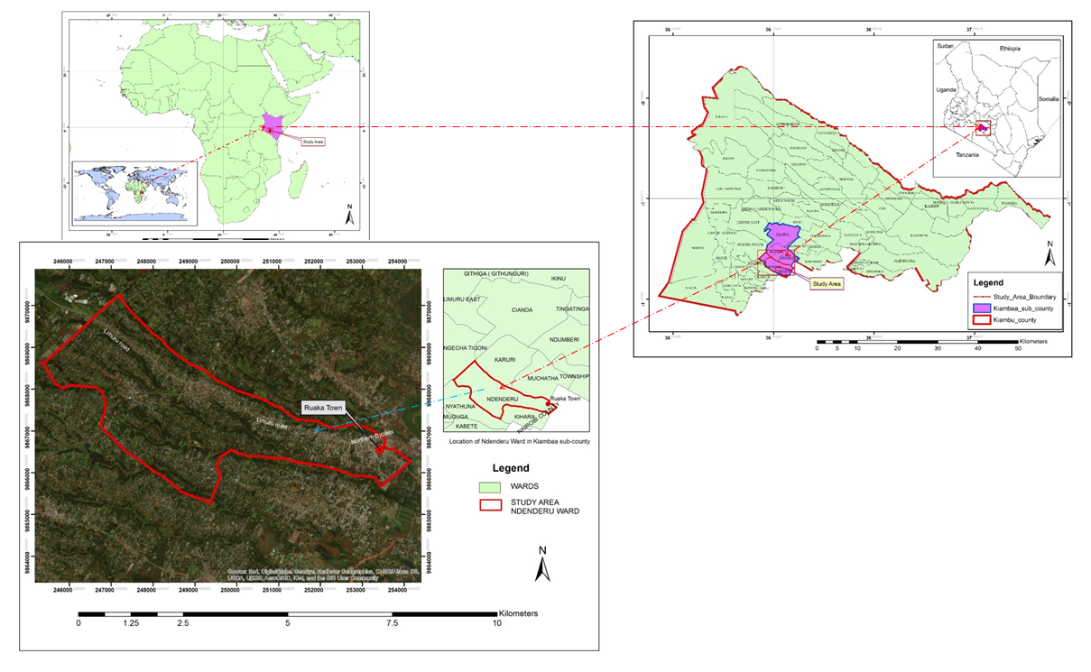 | Map 1. Location of Ruaka in Africa, Kenya and Kiambu County Context |
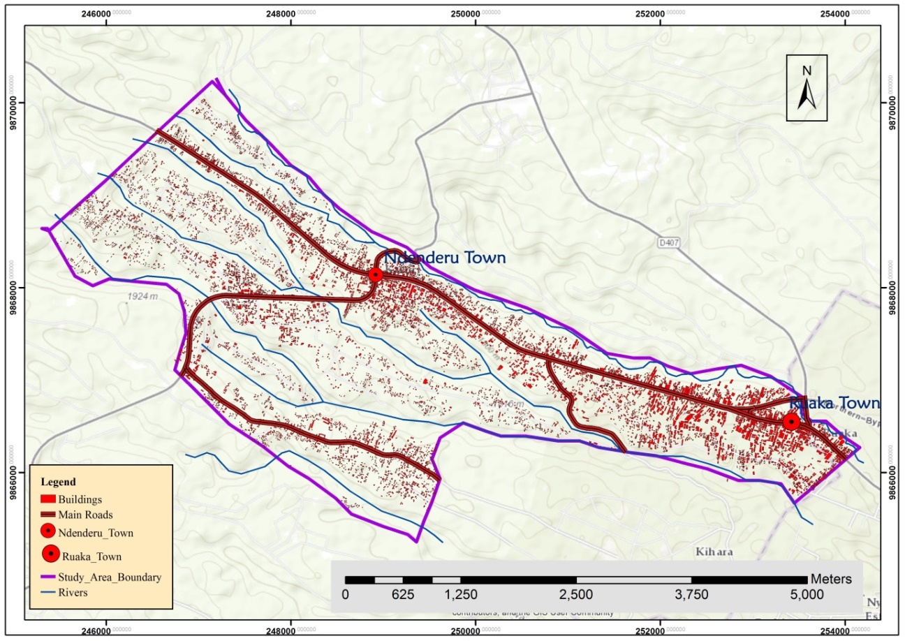 | Map 2. Built-Up Developments Trend 2019 |
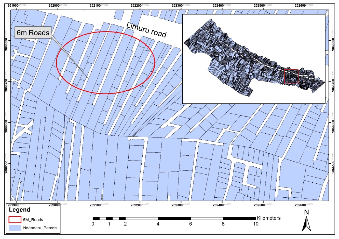 | Map 3. Level of Land Subdivisions |
2. Theoretical and Methodological Approaches to Urban Land Use Differentiation
- Mapping land use changes are critical in determining the socio-economic patterns of changes. Past studies on urban land use change have been undertaken using Geographical Information System (GIS) and remote sensing tools (Screenivasulu et al, 2013) [56]. Therefore, GIS has greatly assisted in the collection, storage, display, detection and analyzing of the land use changes. Classification is used in analyzing Landsat imageries acquired over a period of time to correlate the changes that have taken place over a period of time. Satellite imageries are used in analyzing the nature of changes for the built environment and vegetation cover. Landsat Multispectral Scanner (MSS), Enhanced Thematic Mapper Plus (ETM+) and Thematic Mapper (TM) have been widely used in several studies in the determining land use changes over a period of time because of their high spectral resolution (Reis, 2008) [53]. Remote sensing and GIS have been used to collect data in past studies to fill a gap in knowledge on land use changes such as the case of Chhatarpur District in India when satellite imageries were used to prepare land use maps which were then used for developing sustainability strategies. (Nishra et al, 2012) [44]. Towards this end, it is evident that Remote Sensing and Geographical Information System (GIS) are imperative in land use planning and policy development more so in monitoring land use patterns and changes. Many studies in North America and West Europe have demonstrated that high-resolution satellite imageries are vital in collecting information on land use changes. Therefore, areas experiencing rapid urban sprawl can be monitored using satellite imageries to assist Planners and policymakers in resource allocation and policy decision on areas for development and other strategic interventions (Billah and Rahman, 2004) [7].The first of these theories is the bid rent theory consisting of the postulations of Alonzo and Weber among others. The theory explains land use competitions in a city by stating that land uses to compete with one another for land close to the city center which is more accessible and has an agglomeration of economies (high concentration of activities and people) thus higher chances of making a profit (Sullivan, 2012) [59]. As a result, prices of land in the inner cities are higher compared to other locations. The Bid Rent Theory explains why land in Ruaka at the outer ring of the Nairobi city attracts more residential and commercial developments with developers and tenants ready to pay higher rent to establish their businesses as it’s more accessible to a wider population. Alonso (1964) [2] advanced a model based on land values based on the location and size of land. The model assumed a city of uniform employment and shopping centres and equidistant travel distances. It also assumes that each household or firm has equal opportunity and access to market information on the cost of land and commuting costs. In this case, many household choices are based on cost and location (distance) of commuting. The theory partially explains differentials in land prices towards Ruaka town. Weber (1929) [65] viewed a city spatial structure as a culmination of human socio-economic interaction as aided by the transportation network. Suburbanization theory postulates the expansion of the city to the periphery. According to Adefioye (2016) [1], due to demographic and economic factors cities expand to the periphery forming adjacent territorial centres. This is attributed to the high cost of land within the city and need for large spaces for urban activities which have often resulted in a shift of residential and commercial land uses from the city center to suburban areas which are within city limits. The theory of suburbanization explains how Ruaka Town emerged as a result of its close proximity to Nairobi city. Labour Aristocracy thesis has been used in Africa to explain the rural-urban migration. The theory is an amalgamation of two theories notably labour mechanism and urban bias theory. Labour mechanism states that owing to labour differentials between rural and urban areas, labor moves from rural to urban areas. Urban bias theory contributed by Lipton (1977) [39] states that governments tend to centralize investments and activities in urban areas compared to rural areas thus good life accentuated by electricity, piped water, good housing, and telephony. This attracts the rural counterparts to migrate to the urban areas to enjoy the privileges hence abandoning the rural areas only to find out that it’s not all that good as expected thus urbanization of poverty. Labour Aristocracy theory tends to demonstrate how people move from rural areas to Nairobi city with an expectation of high wages as opposed to actual wages. This forces them to look for alternative places outside the city which in this case is Ruaka town thus accentuating the demand for housing and commercial services. This has seen rapid land use changes from agricultural to residential and commercial users.Hoyt (1939) [31] developed sector model to explain the internal structure of cities. The model posits that cities grow around a series of sectors radiating from the CBD and centered along major transportation corridors with similar business enterprises clustering and locating along the major roads. Rent then graduate downwards from the CBD towards the peripheral areas. In this regard, residential areas along the major thoroughfares tend to attract commercial activities as is witnessed in Ruaka town with the emergence of banks, supermarkets, and offices among others. Burgess (1925) [8] advanced the concentric model to explain the internal structure of the North American cities. The model explains how a city’s social groups are spatially arranged in a series of rings notably the Central Business District (CBD), Zone of Transition, Zoning of working men’s home and commuter zone. This model demonstrates that due to urban growth, each zones gets invaded by the adjacent zone as the city expands outwards. This explains the outward expansion of Nairobi city to Ruaka town hence leading to the land use changes. Arising from the weaknesses of sectoral and concentric models it explains the urban internal structure. Harris and Ullman (1945) [28] developed a multi-nuclei model to explain the urban internal structure. The model postulates a city’s growth from several CBD patterning the land use from which other land uses gravitate. A study by Mwathi (2016) [48] on effects of land use and land cover dynamics on the environmental quality of Nairobi and its environments evaluated the trends, rate and nature of land uses and land cover initially from 1988 to 2010. The study indicates that the city has continued to expand, marked by a decrease in the agricultural and riparian vegetation. This has led to environmental degradation corroborated by land degradation, degradation, and destruction of habitat, air, and water pollution as well as urban heat island. The study concludes that this is occasioned by the weak institutional framework for development control and the proliferation of informal settlements in the urban periphery. The study recommends that for sustainable development of the city, there is a need for enhancement of development control, expansion, and maintenance of the infrastructure, formulation of up to date and relevant policies as well as embracing a multi-sector partnership approach to urban development. Asoka et al (2013) [3] studied the effects of population growth on urban infrastructure and services in Eastleigh Neighborhood, Nairobi and observed that solutions to urban problems depend heavily on effective urban planning, infrastructure development, and management. The study reveals that rapid and unplanned growth has led to a strain on the capacity of infrastructure and environmental degradation.Museleku (2013) [47] carried out an investigation into causes and effects of agricultural land use conversions in the urban fringes of Nairobi-Kiambu interface and found out that there was the prevalence of conversion of agricultural land whose effects were both positive and adverse. The study reveals that land conversions are as a result of low returns from agriculture, high demand for housing facilities, urban population growth, weak and ineffective development control institutions and close proximity to Nairobi city. To ameliorate the ravages of land conversions, the study recommends the adoption of proactive development policy (legal and institutional frameworks) to control developments. Although the study analyzed how land conversions exert pressure on existing infrastructure, the study never recommended a framework for the management of the same.Kirigwi (2008) [35] carried out a research on the effects of rapid urbanization on land use in the Nairobi urban fringe a case of Ruaka town. The study aimed at making an inventory of developments in an attempt to find how they conform to local development policies. The study revealed that there were increased subdivisions of agricultural land and changes of the user from agricultural to built up ones consequently leading to the destruction of natural vegetation. The study established that the defunct local authority didn’t have the capacity to resolve the rapid land use changes and development to the riparian reserves. The study recommended the need for preparation of a physical development plan alongside with the reduction of bureaucratic procedures on the plan approval process and developments. It also noted the key challenges of bureaucracy in the harmonization of policies for the management of urban sprawl. The drawback of this study is its failure to analyze how the developments impact on the infrastructure and how this can be managed. Mundia and Aniya (2005) [46] posit that urban expansion as accentuated by economic growth and expansion of transport corridors often lead to urban sprawl and loss of land cover. According to Kumar and Sangwan (2013) [37], urban sprawl and land use changes are occasioned by urbanization, population, and economic growth. This necessitates land use planning and administration with long term monitoring and management. Olujimi (2009) [49] argues that despite many attempts by national and international agencies at containing urban sprawl, not much has been achieved. This necessitates a re-evaluation of the strategies used to contain the sprawl. Olujimi (2009) [49] suggests a people-oriented strategy in managing sprawl with facilitation by government officials as it is essential to plan with the people rather than to plan for the people. a. DRIVERS OF LAND USE CHANGESLandsat images have been used in previous studies to analyze drivers of urban land use changes. The main causes of land use change established from such studies demographic, climatic, geographic and socio-economic factors with others being proximity to highways (Lo and Yang, 2002) [40]. Drivers of land use changes are essential to aid in making recommendations and decisions on future land use patterns (Samie, et al, 2017) [55]. Previous studies indicate that remote sensing imageries are essential in mapping land use changes, investigating the nexus between land use changes and the key drivers as well as assessing the impacts of the same within a period of time for purposes of rational urban management. Outcomes from the case of Wuhan city in China indicates that over a period of time, there were substantial land use changes on the arable land to built-up environment occasioned by socio-economic (population increase and industrial developments, physical, cultural and climatic factors as well as policy considerations) (Xiangmei et al, 2016) [67].Population growth is a key driver to land use changes which has often led to urban sprawl. This would be through a natural increase in population or migration to urban areas as a result of pull and push factors such as proximity to workplace, availability of land, perceived better facilities and services, economic opportunities, conducive climate and environment among other reasons. The increased population strains the capacity of existing urban infrastructure and services. Independent decision made by the government or private sector especially in areas that lack development guidelines often leads to land use changes and in most cases uncontrolled and uncoordinated urban developments. Economic growth of regions has seen land use transformation with massive urban developments and land conversions from agricultural to built-up areas. Other key drivers to land use changes include industrialization, land speculations (expectations in land appreciation), changes in development and property tax, high living cost an property cost in the city as compared to the peri-urban areas, lack of affordable housing within the precincts of the city, demand for more living spaces due to limited land size within the city, government regulation that concentrates regulation within the core city as opposed to peripheral areas, effects of new development corridors attracting urban developments and failure in enforcement of planning policies and regulations (Bhatta, 2010) [6].In the epoch of global urbanization, cities of the south are facing rapid urbanization with land use changes challenges that are detrimental to urban sustainability. Such unprecedented population booms and variant economic trends pose stress on finite urban land resource and infrastructure. Urban sprawl has been witnessed with its challenges of vegetation destruction and environmental degradation manifesting through decreased air quality, increased surface water runoff, flooding, deterioration of water quality and increased urban surface temperatures among others if not well managed (Subramani and Vishnumanoj, 2014) [58]. Other studies reveal that land use changes mainly brought by urbanization have resulted in floods which can be predicted although not successful through the type of land uses which are mainly commercial, residential and industrial. Other sources of floods include aging drainage infrastructure, increased urban developments, increased paving and climate change. In other instances, floods have been caused by lack of drainage especially in an urban area mainly because most of the drainage networks are dilapidated and therefore cannot handle the increased volumes of water (Saberifar and Shokri, 2017) [54].b. POLICY, LEGAL AND INSTITUTIONAL FRAMEWORKPolicies, laws and institutional arrangements guide the urban growth and development in various ways as defined out below: - Policy FrameworkKenya Vision 2030 (GoK, 2007) [19] is a long-term development blueprint with economic, social and political pillars. The aim of the blueprint is to transform Kenya into a newly industrializing middle-income country providing a high quality of life by 2030. The blueprint anticipates that 60% of Kenyans will be living in urban areas by the year 2030. This requires an effective management strategy to enhance the achievement of the economic, social and political gains in urban development, more so for highly urbanizing towns such as Ruaka. Kenya Vision 2030 (GoK, 2007) [19] is also complemented by the National Spatial Plan whose aim is to achieve sustainable population and human activity distribution on national space to attain socio-economic development, sustainable use of land and controlled urban developments. Kenya’s urbanization agenda is also geared towards the fulfillment of the Sustainable Development Goals (SDGs) agenda which include the promotion of urban resilience in infrastructure and making cities inclusive, safe and sustainable. The broader promotion of sustainable urbanization as anchored in the SDGs is operationalized by the National Land Policy (GoK, 2009) [20], National Housing Policy of Kenya (GoK, 2004) and the National Urban Development Policy (GoK, 2011). The National Land Policy (GoK, 2009) established under Sessional Paper No. 3 of 2009 aims at guiding on efficient, equitable and sustainable use of land to address socio-economic, environmental and political concerns. In the urban arena, the objective of the policy is to promote the management of urban land uses within a planned framework ensuring that they are undertaken to meet order and urban sustainability. While the National Housing Policy for Kenya (GoK, 2004) aims at providing adequate, decent and affordable housing for all citizens, Draft National Urban Development Policy (GoK, 2013) [27] creates a framework for sustainable urbanization through infrastructure, housing, land, environment, and climate change management. It also recognizes that walking and cycling has been given less attention despite being the key mode of transport and calls for strategies and standards that emphasize on safe pedestrian and cycling facilities, efficient, reliable and high-quality mass transport systems and well-designed public spaces in towns and urban areas.Legal FrameworkThe supreme law of Kenya being the constitution of 2010 in its Article 1 (2) stipulates that sovereign power is vested to the people of Kenya. This power can be expressed through direct participation or indirectly through elected representatives. It places the citizens at the centre of decision making and promotes the public participation and involvement of citizens in decision making, which forms the basis of involving all stakeholder in a consultation process in plan making or any decision that affects them notably; access to adequate and decent housing with reasonable standards of sanitation, access to clean and safe water in adequate quantities. It establishes a devolved system of governance and formation of County Governments with departments of roads and transport, water and sanitation that are responsible in planning and management of County roads, traffic, parking, street lighting, water supply and wastewater management. The Constitution ma constructed, maintained and managed by the National Government. The constitution gives its citizens right to freedom of movement, right to clean and healthy environment and mandates all public officers to respond to the needs of vulnerable members of the society including children, women, elderly, persons with disabilities, minority/marginalized groups. The same is reinforced by the Physical Planning Act (Cap 286) which grants powers for the county governments to control the use and development of land, buildings in an orderly way and to consider approval of development applications. It also provides for the preparation of plans for purposes of improving land and securing provisions for infrastructure facilities and services including giving provisions for new roads and their hierarchies to serve major different classes of developments, streets, subject to provisions of the Street Adoption Act (Cap 406) and Public Roads and Roads Access Act (Cap 399). Other legislation that reinforces the need for sustainable urban development are the County Government Act (2012), Urban Areas and Cities Act (2011), Environmental Management and Coordination Act (1999), National Land Commission Act (2012), Land Act (2012), Water Act (2012) and Building Code (Adoptive By-laws (1968) among others. The County Government Act (2012) provides for the preparation of planning and management frameworks under Section 104 thus granting powers to the county government powers to plan and manage its areas within its jurisdiction. The Urban Areas and Cities Act (2011) provides for the classification, management, and governance of urban areas; the criteria of establishing urban areas, principles of governance and public participation of residents. Parking, public transport, sanitation, water supply and street lighting are enlisted as requirements of classifying an area like a town or municipality. While Environmental Management and Coordination Act (1999) provides for the management of the environment, sustainable use of land its natural resources and requires all urban infrastructure projects to undergo environmental impact assessment and social impact assessment before construction. National Land Commission Act (2012) provides for administration and management of public land in an efficient, sustainable and equitable manner. The act also mandates the National Land Commission with the responsibility of monitoring and providing oversight over land use planning and alienation of public land to private entities, monitoring registration of rights and interests in land. The need to equitably and efficiently utilize land and natural resources as further reinforced by Land Act (2012) and Water Act (2012) which collectively provides the legal foundation to consolidation and rationalization of management of land and the management, conservation, use and control of water resources. The Building Code (Adoptive by-laws) of 1968 provides for the development control processes and procedures of erecting developments and penalties for defiance. c. EFFECTS OF LAND USE CHANGESLand changes have taken place in various parts of the world with a greater decline in land cover and increase in the built-up areas resulting in economic, social and environmental impacts. The decline in farmlands has an impact on the decline in food production and the rise in the cost of purchasing food products. Densification and built up areas increase water and air pollution as well as the rise of thermal temperatures of the areas (Wu, 2008). Other impacts of land use changes include impacts on wildlife and ecosystem, loss of farmland, increase in impervious surfaces, the decline in air quality as a result of car-dependent lifestyle, the decline in water quality and quantity since the aquifers are not replenished due to increased impervious urban surfaces (Bhatta, 2010) [6]. Urbanization and land use changes have often resulted in disturbances of land and its hydrological systems pose a serious risk to the provision of urban water services, drainage capacity, increases pressure on urban water systems and affects their water quality, quantity and aquatic ecology depending on where and how they occur (Huggett et al, 2004) [32]. Urban areas with massive developments located in flood-prone areas are usually prone to flood hazards as a result of increased impervious urban surfaces such as roads (Du, 2010) [13]. Changes in land use through urban development often have impacts on transportation (roads) such as changes in travel demand and mobility. Land use changes, therefore, lead to road expansion and creation of new roads as a result of urban growth that requires wider roads to enhance mobility and safety. This often attracts more urban developments to provide urban facilities for the larger population which results in an increase in pressure on urban ecosystems, aggravates urban congestion and threatens biodiversity conservation, noise and air pollution (Marimoto, 2012) [42]. Studies in the United States and Europe reveal urban form as a key driver to travel behaviors. Policies advocating for the transformation of this trend have been formulated to reduce transport emissions, reduce traffic congestion, improve safety and enhance security on roads. Studies on the impact of urban form variables such as urban density, city size, land-use mix, spatial clustering, and polycentricism were analyzed in relation to time and distance. It was deduced that spatial clustering and city size are determinants of commuting and therefore cities that lack the clustering and limits in city size have problems with commuting. Therefore, city limits and clusters, especially for the high density, enhances limit in the commuter distance and travel time (Engelfriet and Koomen, 2018) [14].Floods brought by land use changes/urban developments have led to the destruction of property and loss of life and therefore if not controlled the situation can worsen with the increased level of land use conversions which has seen a rise in flash floods in urban areas. The floods have been accentuated by the impervious services as a result of urban developments which does not allow a substantial amount of surface runoff water percolation to the ground. The surface runoff water is also obstructed by non-biodegradable materials which often clog the drainage systems and as a result end up into sewerage drainage and water supply systems leading to spillovers, pollution, and contaminations endangering the life of people and the ecosystem. The impacts of such floods are experienced on roads especially where the drainages are not maintained or do not have the adequate capacity to contain the stormwater which makes the roads impassable (Mukherjee et al, 2016) [44]. Land use changes and urban development have led to the expansion of paved surfaces and as a result, has led to encroachment of riparian reserves. The immediate effect of such encroachments has posed flood risks to such areas and disrupted ecosystem services of such riparian reserves (Orewole et al, 2015) [50]. Water shortages have been a growing concern throughout the world with ongoing droughts, water rationing, climate change, and global warming. This has been attributed to the high population growth rate due to urbanization and the high rate of land use changes which exert pressure on already limited existing water supply (Tamara et al, 2016) [60].
3. Case Studies of Best Practices on Management of Urban Infrastructure Systems
- Sustainable urban infrastructure systems in the best practices ensures that the transportation and urban infrastructure systems support the economic vitality of the region in a cost-efficient and affordable manner, meets the social needs of the people in terms of their accessibility, safety, security, inclusive of the disadvantaged and disabled groups as wells as creating solution which reduce environmental pollution and degradation. Managed urban growth and land use changes often has numerous core benefits such as minimized cost of growing and operating an urban area, reduction of effects on transportation systems, reduction in depletion of agriculture land, making land scarce and affordable, reduction in pressure on environment, enhance urban design and aesthetics of undesirable features, enhance efficiency in provision of social needs and enhance economic balance through local economic development. In addition, financial muscles and political will is vital in the implementation process of urban infrastructure and should be highly emphasized to ensure smooth execution of project proposals. Best case studies indicate how effective management of its urban infrastructure systems has been successful. Case of Zurich’s Transport Management SystemsZurich is one of the most densely public transport networks in the world but it has the easiest access which is quick and reliable making it one of the best transport systems in the world. It is estimated that 44% of its residents or commuters use public transport to the workplace and that just 28% of all journeys are taken by car. The system works well due to its urban management systems which are integrated with multi-modal passes. The coordination is done by one agency with several transport lines which exhibits its technical dimension in the management of its urban infrastructure. The management ensures high-frequency departures which run day and night with regularly targeted fare reductions. The management has also ensured that future developments are built around the public transport lines or within walking distances to public amenities and shopping areas such as schools, shopping malls and work places. Zurich has traffic monitoring systems, quality of service with high operating frequencies of trams and integrated networks which led to the success of its public transport system. The benefits gained from such efficient and integrated transport system has attracted businesses and growth in the economy of the city, high reduction of greenhouse gas emission making Zurich the lowest in emissions in Europe at 5 tonnes per person and boosted the social life of the city as it is ranked amongst the top cities in the world with high quality of life.Case of Toronto’s Transport Management SystemsThe main challenge in transportation in most cities such as New York has been the ability to meet the traffic congestion and developing transportation networks due to the growing population. The ability to the said challenges has been due to financial constraints and limited space. In the process of building new infrastructure and coordinating the systems can improve and increase the transportation capacity in the short-term period. Toronto has created overlapping networks of various transportation modes such as buses, subways, streetcars, bike shares and car shares which are integrated and linked by easily accessible real-time information systems. The integrated mobility has improved the transportation system and increased its capacity which should be replicated in other cities and towns such as Ruaka town through the integrated mobility strategies which focus on coordination of existing transport systems to increase their connectivity and capacity.Case of Singapore’s Water Resource and Waste Water Management SystemsWater Resource Management SystemsSingapore is a small populated city which is considered a water scarce country due to its limited land area available to tap water, lack of groundwater resources and the increasing population although there is plentiful rainwater. It has managed to get out of this situation through urban management strategies, institutional reforms and sound urban governance which has transformed it to the most reliable and model for successful water resource management in terms of its accessibility, reliability and sanitation standards to its population. It has emphasized on the adaptability and management of water supply and demand to ensure high water quality standards, reliability, service quality, sustainability, finance and efficiency. This has been made possible through integrated water resource management with the diversification of water supply, expanding and building water reservoirs, management of water demand through pricing, enforcement on water conservation measures, importation of water and desalination of water. Singapore has integrated innovative approaches to water management which has intervened on problems of water supply and attained sustainable and cost-effective water management solutions. It has established long-term water supply strategies known as Four National Taps for collecting water from local catchments, NEWater-reclamation of water, desalination of water and importation of water. NEWater is a Singapore success story that exemplifies the determination of managers to turn challenges into opportunities from dirty to ultra-clean, high grade reclaimed water being a key innovation that Singapore invented that is a weather-resilient solution that cushions water supply against a dry water. Political and government commitment to the realization of sustainable urban water management has promoted its success by giving water a top priority (Chiplunkar et al, 2012) [9]. Singapore uses a progressive water tariff structure that penalizes the inefficient use of water for domestic water consumption that exceeds 40m3 per month (Tortajada, 2006) [61]. Lessons from Singapore can assist urban managers to adopt resilient urban infrastructure management systems that maintain infrastructure as opposed to building more or expanding the infrastructure. Rehabilitation and promotion of flexible development of new infrastructure services promote the sustainability of developments. There is a need to identify assets likely to suffer in case of future urban expansions and other vulnerabilities and provide solutions to curb such menaces. It is essential to identify the aging infrastructure or approaching the end of the design life and retrofit it or build new resilient urban infrastructure. In addition to the technical dimensions, there is a need to involve the public in the implementation of such projects for public acceptance and confidence for the project to succeed as demonstrated in Singapore. This is through a public engagement campaign to educate the public on the stringent process of water production and how to maintain water safety for drinking. This can be achieved through public media and community engagement programmes that ensure community understanding and support. The governance of Singapore has led to a remarkable transformation and success stories of water infrastructure management. If infrastructure managers implemented the same formula, they will equally succeed through meritocracy which means the best people to be selected to run the infrastructure, pragmatism which means whatever ideology and policies works should be used and honesty in management of infrastructure through non-corrupt, transparent and accountable practices.Wastewater Management SystemsSingapore has a holistic water management system that integrates both water and wastewater in providing clean water and proper sanitation to its citizens. In the management of wastewater, they have ensured high service coverage of waste management systems to serve urban areas. Their systems have a high rate of monitoring to increase detection in rates and areas of blockages to ensure that they are accurately registered. Singapore has laid concurrent emphasis on supply and management of wastewater, equity, efficiency, institutional effectiveness, an enabling environment with strong political will and effective regulatory and legislative frameworks. It has also ensured that there is collaboration and sensitization of its stakeholders (Tortajada, 2006) [61]. Singapore has substantially invested in wastewater infrastructure and ensured all industrial estates and residential areas are served with the public sewerage system and the management ensures that all wastewater is discharged into the public sewerage system. The wastewater systems are separated from stormwater drains whereby wastewater systems are directed to wastewater treatment plants and recycled while the stormwater and surface runoff are collected and drained to rivers and reservoirs. The separation prevents wastewater from polluting reservoirs and rivers and also stops stormwater from draining to wastewater infrastructure causing overflows. Singapore has ensured strict enforcement of the legislation to ensure proper management of wastewater and minimize pollution and contamination. It is mandatory for all developers to connect to the available sewerage system. Proposals of developments are scrutinized to prevent any damage to the existing wastewater infrastructure systems (Chiplunkar et al, 2012) [9].Case of South Africa’s Water Resource Management SystemsSouth Africa has used water pressure management technology in the management of its water resource through Public-Private partnership to the water supply system of Sebokeng and Evaton which are two of the high to medium density residential areas. The technology ensures minimization of water loss by controlling the pressure in the water supply and distribution networks as well as lowering the tariffs through reduction of energy used for pumping water. Assessment done in these areas indicated that excessive high pressure in the water supply networks particularly during the off-peak hours caused damage to the pipes and fixtures leading too excessive water loss through leakages and wastages. High costs for repair, replacement, maintenance and management of the water supply systems were incurred. The advanced water pressure reduction installation plant reduced the water pressure during the off-peak hours and allows to reduce pressure at night which also reduces leakages. This reduced the amount of water wastage significantly.
4. Concepts, Strategies, Standards and Principles in Management of Infrastructure
- Management Concepts and Strategies for Roads and Transport SystemsManagement of the transport system and roads require sustainable management strategies and solutions. Smart and intelligent infrastructure require design principles, concepts and strategies. They include people-centered and inclusive infrastructure, resilient and sustainable infrastructure, interoperability and flexibility, managing risks and ensuring safety. The triple bottom line framework is to integrate the social, economic and environmental elements. Economic element in the management of roads and transport will support the economic vitality in the development of urban infrastructure in a cost-efficient manner. The cost of transport and general management should be affordable to the households which they are willing to pay. The transport and roads management should address the social needs by making transportation and road networks accessible, safe and secure and should be done in an equitable manner to accommodate the disadvantaged groups. Management of roads and transport infrastructure should create solutions which enhance environmental conservation, reduce emissions and pollutions such as the use of non-motorized transport and pedestrianization of some of the streets.Best practice paradigms have advocated for sustainable management strategies which enhance an effective and efficient transport system which includes avoid strategies, shift strategies and improve strategies. Avoid strategies focuses on system efficiency to reduce or avoid the need for travel. This can be achieved through advocating for compact and mixed-use developments as well as pricing and regulatory mechanisms through the introduction of levies for those who use private means of transport during the peak hours. Shift strategies are aimed at improving trip efficiency includes the shift from energy intensive to walking cycling and public transport. This can be achieved by making cycling safer and attractive, promotion of public transport, provision of adequate and safe public spaces, improvement of street designs, seamless link between walking/cycling with Public Transport systems, Park and Ride facilities, Pricing and regulatory mechanisms to discourage private car ownership vehicles to the CBD area especially during peak hours and promoting alternative options such as carpooling, bicycle sharing. Improve strategies enhances vehicle efficiency through pricing and regulatory mechanisms with alternative means of transport such as ropeways technology, cable cars, electric trains, battery cars among others.Management Principles for Roads and Transport SystemsStreets ensure the mobility of residents from one location to another as well as become joints of meeting and interaction, business and recreation activities making towns livable. Decisions made on such streets and roads have a great impact on the quality of life in such areas. It is essential to enhance the safety and security of all road users and more especially pedestrians, cyclists and any other form of non-motorized means of transport.The principle of complete street designs enhances safety, efficiency and modal hierarchy. In designing for safety, the design of streets dictates the speed limit along such streets or roads. Streets that regulate and encourage low-speed limits encourage the non-motorized means of transport and pedestrian use hence enhancing the safety of such road users. All roads should have safe streets and roads with street lighting dedicated lanes for Non-Motorized Transport (NMT) users and Cyclists and secure pedestrian crossings. Mobility should enhance efficiency, convenience and safety of road users from their origin to their designation. This can be achieved through high capacity and high-quality public transport systems. Road widening at the initial stages increases the efficiency or road users and encourages more people to own private cars but in the long run, the transport routes become congested and therefore road widening has never been a long-term solution to traffic problems. Therefore, the only long-term solution is by the use of high capacity and high-quality mass transport facilities and systems such as the Bus Rapid Transport as well as the non-motorized transport (NMT). Other solutions to reduce traffic congestion by reducing the number of vehicles on roads rather than by widening roads to accommodate the ever-rising number of vehicles is by increasing parking fees, congestion pricing and among other measures. In designing the modal hierarchy in the provision of infrastructure and facilities, more attention should be given to pedestrians, non-motorized transport/cycling and public transport with least attention given to the motorized transport especially the private car ownership. The design of roads should ensure more space is allocated to pedestrian and cyclist lanes as opposed to the roads. Therefore, the priority networks should be the pedestrian networks, cycling networks and public transport networks. Pedestrian networks must be complete, have the shortest and direct connecting route, publicly accessible and safeguarded from vehicular traffic to enhance the safety of pedestrians. In areas with large blocks, redevelopment of such areas should correct such anomaly where such an opportunity arises to correct it. Areas with frequent pedestrian users should have pedestrian crossings where there are slow speeds and fewer volumes of traffic. Traffic control and traffic calming measures should be used in areas with faster speeds with high volumes of traffic. Efforts should be made to revitalize open spaces for relaxation and recreation especially in routes designed for NMT users. Public transport systems should be connected in a seamless manner with the Non-Motorized Transport (NMT) for ease of transition from one mode to another. Cycling networks require dedicated lanes with physical separation to ensure the safety and comfort of cyclists in areas with high volumes of traffic. Short routes should be designed for cyclist lanes to key destinations more especially to facilities within residential areas and to work places with signage located at strategic locations for easy navigation. Public transport being a non-profit entity should be affordable and reliable to allow passengers to travel whenever they want. Management of roads and transport systems should ensure that such systems and facilities are accessible, affordable, reliable and acceptable. Availability of such public transport system should be in terms of route possibilities, timings and high frequencies. Management of public transport should ensure that such systems are acceptable by the users in terms of their comfort, cleanliness, personal safety and security. Public transport systems move large volumes of people faster and efficiently while occupying smaller space as compared to the private car as a means of transport. Efficient public transport system must offer dedicated right of ways such as BRT lanes on high traffic transport corridors. Motorist networks should be restricted to ensure efficiency and safety of pedestrians, cyclists and public transport systems. Effective regulatory measures must be put in place to regulate private transport systems and motorist lanes especially those near schools or public facilities to observe low traffic speeds. Ancillary amenities and sanitation facilities installations should be mandatory at destinations and considerations made for people with disabilities, elderly, sick, children and women. Street elements including raised footpaths for pedestrian zone, frontage zone and furniture zone, wide cycle tracks, raised, direct with universal access crossings at areas of concentration of people, carriageways which are not too wide, bus stops with weather protection, landscaping, sufficient vending space, street lighting, aligned street furniture, storm water, appropriately sized and calmed service lanes, utilities, on-street parking, safe, universal access, and direct footbridges and subways must be planned and managed in a better way to create efficiency, easy accessibility and manoeuvrability, safety, security, comfort and unconstrained movement.Level of Service and Standards in Management of Water Supply SystemsManagement of water supply infrastructure requires its improved accessibility, equity in distribution, reliability, safety and quality, adequate quantities and acceptability in taste, smell and colour. Implementation of water infrastructure management must be done in an integrated approach to achieve an adaptable and resilient infrastructure which gives access to safe water and sanitation all groups including the disadvantaged groups. All stakeholders must be involved in the coordination and management of water supply systems. Wastewater should be recycled and reused in agriculture and open spaces management. The infrastructure must adapt to upgradability and modification in case of urban expansion and population growth. Management of water management should be decentralized to enhance high efficiency and effectiveness in its management. Level of service provision and quantity of water collected is vital to promote its hygiene and therefore the recommended basic access to water within 1km distance and 30 minutes should be an average of 20 litres collected per capita per day. The optimal access and consumption of water is estimated at an average of 100 to 200 litres per capita per day and supply of piped water being through multiple taps within the house (Howard and Bartram; WHO 2003) [30].
5. Conceptual Framework
- Land use changes entail the drivers and effects of land use changes as highlighted from the previous studies and theories on land use differentiation. This forms the basis of the conceptual framework. The land use changes are the independent variables, urban infrastructure capacity being the dependent variable, intervening variables being natural growth, urbanization, population pressure, socio-economic and political factors. The effects of land use changes on urban infrastructure capacity include low capacity and poor condition of roads, low capacity and unreliable water supply systems and poor wastewater infrastructure management systems such as septic tanks which leads to pollution and contamination. Interventions on infrastructure management would be through the technical, economic, social, environmental and political dimensions which can aide in evolving a management strategy to unravel the adverse effects on urban infrastructure.In evolving a management strategy to deal with the effects of LUC on urban infrastructure systems, the focus should be placed on dimensions of managing urban infrastructure with an aim of making them efficient, sustainable and resilient. Key emphasis must be laid on efficiency which looks at minimizing wastes, sustainability aiming at taking into the meaningful utilization of resources by the current generation without compromising on the ability of the future generation to utilize the same while resilience focuses on the proper functioning of urban infrastructure systems even after major shocks. In this regard management of the effect of land use changes on urban infrastructure, capacity should look at the technical, economic, environmental, social and jurisdictional dimensions of management.
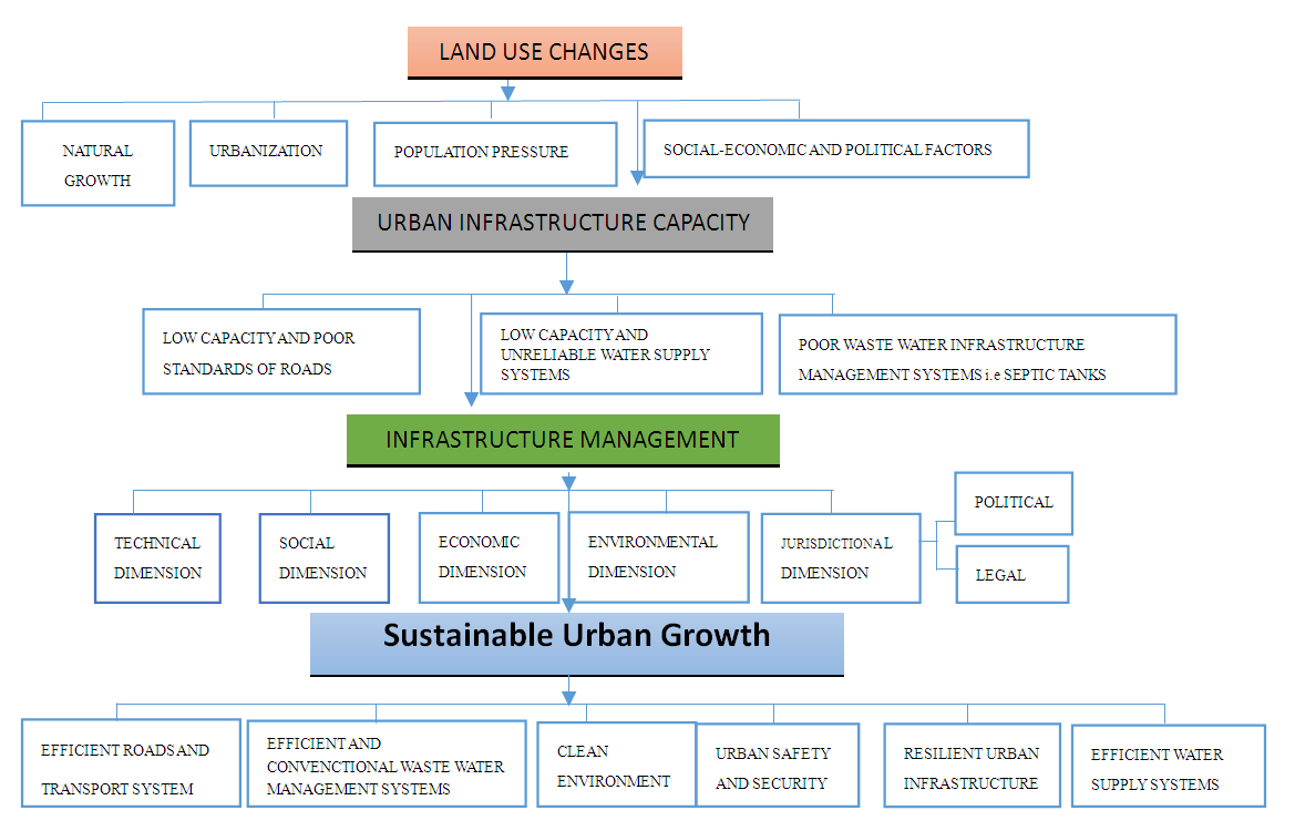 | Figure 1. Conceptual Framework |
6. Study Methods
- Quantitative and qualitative techniques of data analysis were used in the study research design. Descriptive design was used in the description of trends and comparisons of data findings to give an accurate and valid representation of the variables. Content analysis of books and journals were used and case studies were used to depict the best practices which were used in making recommendations. The main target elements are urban built-up areas or buildings, vegetation and agriculture land. Other target populations include Ndenderu ward residents, the business community and developers and County Government officials. The study adopted a random sampling design for the household questionnaires which mainly targeted the residents, business community and developers in Ndenderu Ward. It was essential to formulate a working formula to arrive at the sample size within the study area. In order to get a sampling size, Kothari (2004) [36] formula for finite population size was used to get the right sample size: -
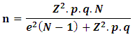 Where n = Sample sizeN = 35,750 (Population)Z = 1.96(the value of standard variate at a given confidence level and to be worked out from a table showing area under the normal curve)p = 0.5 (sample population)q = 0.5(1-p)e = 0.05(given precision rate or acceptable error)
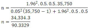 n = 380.08 or 380The sampling was based on confidence level and precision rate concerning the population in Ndenderu Ward. Cochran (1967) [57] states 30% of the population as sufficient for a study. A margin of error of 5%, confidence level of 95% and a sample proportion of 50% was used. A sample size of 380 was selected out of the population of 35,750 of Ndenderu ward as per the 2009 census.Quantitative data was collected from the County Government by administering the questionnaire and scheduled interviews with sub-county officials. The questionnaire was both closed and open-ended questions to seek in-depth information. Observation checklist and photography were also used in the process of data collection. The secondary data contributed to the formation of background information, needed to build constructively the project and the reader to comprehend the research findings. Sources of secondary data were mainly from a literature review of the existing data and previous studies on land use changes, urban growth, urban sprawl, densification and their impacts on urban infrastructure. Primary data on land use changes were collected through analysis of Landsat imageries for a period between 1988 and 2019. Five remotely sensed data Landsat TM 1988, Landsat Enhanced Thematic Mapper plus ETM+ 1995, Landsat Enhanced Thematic Mapper plus ETM+ 1999, Landsat ETM+ 2010, Landsat OLI & TIRS 2019 for a period of 30 years were used for the study. The research data that was used for the purpose of this study comprised of Level 1 Landsat images acquired from Resource Centre for Mapping of Resources for Development and in particular Landsat-5 Thematic Mapper (TM), Landsat-7 Enhance Thematic Mapper plus (ETM+) and Landsat-8 Operational Land Imager (OLI) and Thematic Infrared Sensor (TIRS) imageries.The supplementary data was used from google earth imageries and topographical maps were to generate the location maps for the study area. Classification of land uses in the study area was into three categories notably vegetation, agriculture and built-up areas.
|
7. Findings and Discussions
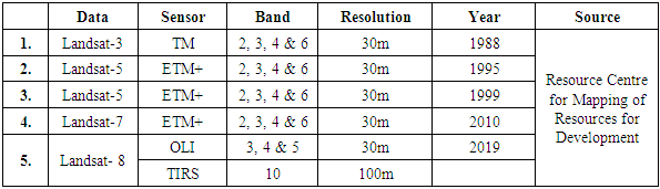
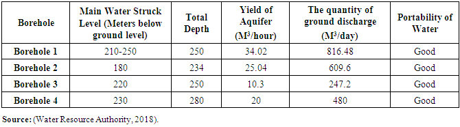
- Effects of Land Use Changes on Urban InfrastructureThis phenomenon of urban land use changes has continued to put pressure on the remaining agricultural land hence suppressing production. Unplanned developments have emerged which has led to a strain on existing urban infrastructure facilities and services. Developments which have sprung up to don’t have an efficient road, water supply, and waste infrastructure systems and therefore without any infrastructure bounded panacea, it may be a peril to the sustainability of the urban infrastructure. Residents use narrow un-tarmacked roads for access, boreholes as the main source of water supply, septic tanks and pit latrines for wastewater management. Road Infrastructure.The area has been undergoing land use transformation with a high rate of land subdivision in the area which seems to be the last straw that breaks the camel’s back. Most of the resultant access roads are narrow as revealed by 60% of the respondents indicated that they are served by 6-metre-wide roads which are not adequate for the high-rise development and densification of the area. In addition, most of the edges along the access roads are not usually trimmed which have caused obstructions along some access roads. Research findings reveal that the existing travel patterns are both internal and external with the travel demand being educational, work and shopping purposes. The modal choice is both public and private with the means of transport being roads. Trip generation is mainly from the residential flats areas going to work or shopping areas. The trip distribution is mainly to Nairobi city. It was indicated by 96% of the respondents indicated that there is reliable public transport in the area. Limuru Road is the main public transport route where public modes ply to and from Nairobi city.Most of the access roads which form streets are connected directly to the main road forming the network with the main node being at Ruaka CBD area. Traffic volume is at the peak mainly during the morning and evening being the time to work or from work and on weekends with main shopping taking place at Ruaka CBD area and nearby shopping malls such as Two Rivers and Roselyn Riviera. The challenges on the major roads revealed by the respondents include presence potholes, murrum roads which are not all-weather roads with weather changes, lack and poor maintenance of stormwater drainage where they exist and lack Non-Motorized/Cyclist lanes provision as indicated by 80% of the respondents. It was noted from the respondents that most roads lack street lighting which makes the area more insecure and unsafe, especially at night. In some areas, there is a security light installation by the private developers along with some streets. Other major effects from roads and transportation included air and noise pollution, climate change, traffic delays, road accidents especially between motorists and NMT users.The main challenge in the area revealed is traffic congestion which is mainly caused by many direct exit points to the main roads, poor condition of roads that slow down movement, parking along the roadside, narrow access roads, presence of commercial activities that pull people, densification and increased high rise developments with high population in the area, presence of institutions such as UN, UNEP, Embassies, proximity to estates such as Runda estate, undesignated location of bus stop at the junction of Ruaka and Banana route as well as high car ownership as revealed by the study that 62% of the respondents owned vehicles. It was observed that there were high motorization rates with a high rate of private car ownership in the area and therefore transport planning was more focused on the car rather than people centered planning and management. Accidents were observed along the major roads particularly between the NMT users and motorists since they used the same road which was not separated. This was a major concern on the level of disparity with a high rate of people relying on NMT but there was the little provision or allocation and funding for such an alternative transport mode. Although the area is not prone to flooding as revealed by 60% of the respondents, it was noted that in some areas floods occur due to high development coverage making the area a concrete jungle, development on natural stormwater drainage way-leaves leading to obstruction of natural water flow and as a result of lack of proper drainage channels. It was revealed from 78% of the respondents that most of the roads in the area do not have the provision of storm water drainage channels and where they exist, they are not maintained.These land use changes have brought a number of effects on roads as revealed from the study such as traffic congestion, decline in condition of roads with potholes with heavy machinery for the ongoing developments in the area, narrow roads as a result of many subdivisions with resistance by developers to surrender part of their land for road widening to accommodate the generated traffic from densification, high ground coverage of developments to cover up the high cost of land in the area as well as surrenders for road widening. High urbanization and population in Ruaka town has seen a traffic problem where the increased private car ownership and use which has been exponential and has resulted in huge traffic volumes. This has seen high travel demand and the generation of trips with different modes of transport vehicular, pedestrian and cycling. It was revealed from the study that 7 out of 10 cars that ply along Limuru Road are private cars. During the peak hours in the morning from 6.00 to 9.00 a.m. and 5.00 to 7.00 pm, there is usually heavy traffic with the travel speed reducing from 60Km/Hour to 15 to 20Km/Hour. This is similar during the weekends especially when most of the residents move to the nearby shopping malls. In addition, Ruaka town lacks a central bus park or designated parking area which has seen indiscriminate parking especially on vegetation/road reserves that have led to the loss of green spaces and pollution. The area is experiencing a rapidly growing economy with a transport paradox experience since it worsens with growth in development. This has seen increased car ownership leading to traffic volumes and traffic congestion leading to global warming, higher emission levels, higher energy consumptions, air, and noise pollution. The high car dependency and increased trips, therefore, demand infrastructure and services which are costly. In addition, the area has experienced increased conflicts among different modes since there is no clear demarcation and dedication of lanes for different modes of transport which has often led to accidents at the junction of Limuru road and Banana Road.Some of the indicators of such densification as a result of land use changes include constant surface run-off and floods which has led to worn out and potholes development of the murrum roads in the area as well as the overflow of stormwater from drainage channels where they exist although they are non-existence in most of the roads. Existing roads lack the drainage channels, walkways, cyclist lanes and street lighting with the increasing densities as a result of the rapid land use changes taking place in the area. Densification of the area as seen traffic congestion due to increased car ownership and more especially on narrow access roads whereby developers are unwilling to surrender part of their plots to pave way for road widening some of which have sharp corners which have often led to accidents. Such narrow roads cannot be adequate enough to provide for stormwater drainage channels, street lighting, and Non-Motorized transport/walkways/cyclist lanes. The main arteries which serve as public transport infrastructure have not been provided with the facilities required for a conventional public transport system such as terminal facilities and proper transit interchanges. On the other hand, there has been a problem with the maintenance and upgrading of the roads with road signage which is crucial to enhance effective and efficient transport system. Although there is no clear infrastructure plan for the area, the construction of western and northern bypass has eased congestion and increased the connectivity of the area.The respondents made the following recommendation to roads infrastructure such as having clear and few direct exit points to the major roads, repairs, tarmacking and maintenance of roads, subjection of all major developments to surrenders for road widening, provision of street lighting to enhance security and safety, County Government to enforce the surrender for road widening on all narrow roads as well as regulate the subdivision levels and subjection of all developers to maintain roads before and after construction in areas where they cause disruption and damages. It was equally recommended better coordination between the National and County government be enhance for efficiency and effectiveness in maintenance and management of roads.Water Supply Infrastructure.Ndenderu ward is not served with piped water but only a small section of Ruaka Town is served with piped water by the Karuri Water and Sanitation Company Ltd. The area has a high population with high demand for water supply who use boreholes as their main source of water with a few connected with piped water within Ruaka Town. Majority of respondents at 94% indicated that they use borehole water while 6% rely on piped water or supply from Karuri Water and Sanitation Company Ltd, 94% of whom indicated that the water supply was not reliable. With the water shortage in the area, households use water of approximately 30-200 litres per household per day with an average of 40 litres per capita per day. Those that are connected experience water rationing and indicate that the water supply is not reliable since its only available for two days in a week and not for 24 hours. Wealthy residents cope up with the erratic services through the use of substitutes such as buying water from the suppliers, boreholes, storage reservoirs and purification equipment to supplement the water supply. The poor who may not pursue this route which is very expensive since they cannot afford, they suffer most as they wait for the water to come or buy from the vendors whose water source and quality is unknown. Karuri Water and Sanitation Company Ltd relies on water supply from four public boreholes distributed in Ndenderu Ward with Gacharage Borehole yield of approximately 15m3 per hour, Kianjogu borehole yields 4 m3 per hour, Ndenderu dispensary borehole yields 25m3 per hour and Wangunyu borehole which yields 4m3 per hour. The total production from boreholes is approximately 48m3 per hour which translates to 18,720m3 per month when pumping daily for 13 hours. Water supply is supplemented by piped water from Nairobi Water Company offtake at Ruaka estimated at 1,500m3 per week and total production of 6,000m3 per month. The amount of water supplied in Ruaka Town is estimated at a total production of 24,720m3 per month with the revenue water being 16,068m3 per month and Non-revenue estimated at 8,652m3 translating to 35% of the total water production. This is the water lost to illegal connection, leakages from burst pipes and distorted meter readings. The bursting of pipes is mainly due to the high vibrations from lorries and trucks in the construction industry, lack of regular monitoring, replacement and upgrading of the piping systems which have gone beyond their lifespan. This has been occasioned by lack of management strategy, funds and political will to prioritize urban water supply and waste management systems. The current 4-inch mains and 1.5-inch reticulation pipes are not adequate and require upgrading and replacement within 10 to 15 years. There are approximately 2,500 individual water connections with an average of 6 people served by one connection. The total population served by water supply is approximately 15,000 people with the water supply of approximately 16,068m3 per month and an average of 1m3 per month per connection which is about 50% of the current projected population of about 36,860 people with total water demand of 2,949m3 per day indicating that the water coverage is low. Water consumption is estimated at 80 litres per person per day within Ruaka which is slightly below the international best practices that require water consumption to be at 100 to 200 litres per capita per day (WHO, 2003) [30]. Currently in the year 2019, it is projected that there are 57, 140 people in Ndenderu ward with an average requirement of 100 litres per day which translates to the water demand of at least 5,714m3 per day which is quite low compared to the current water production. Due to lack of a substantive water source to serve the high demand for water in Ndenderu Ward, there is a rise in the number of private boreholes drilled in the area. However, there are plans to supply the area with adequate water from Tigoni Water supply in Limuru and from the proposed Ruaka Dam estimated yield approximately 10,000m3 per day (Karuri Water and Sanitation Company Ltd, 2019).
|
|
|
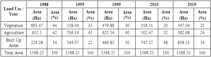
 | Figure 2. Land Use Land Cover Changes Trends |
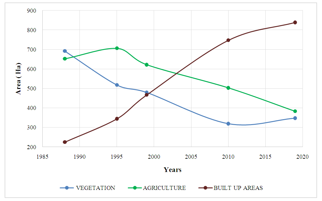
 | Figure 3. Land Use Land Cover Changes Comparison |
 | Map 4. Land Use Changes 1988 |
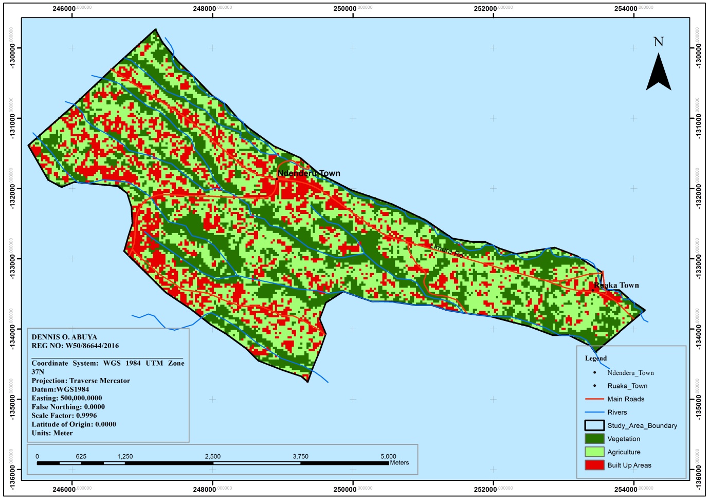 | Map 5. Land Use Changes 1995 |
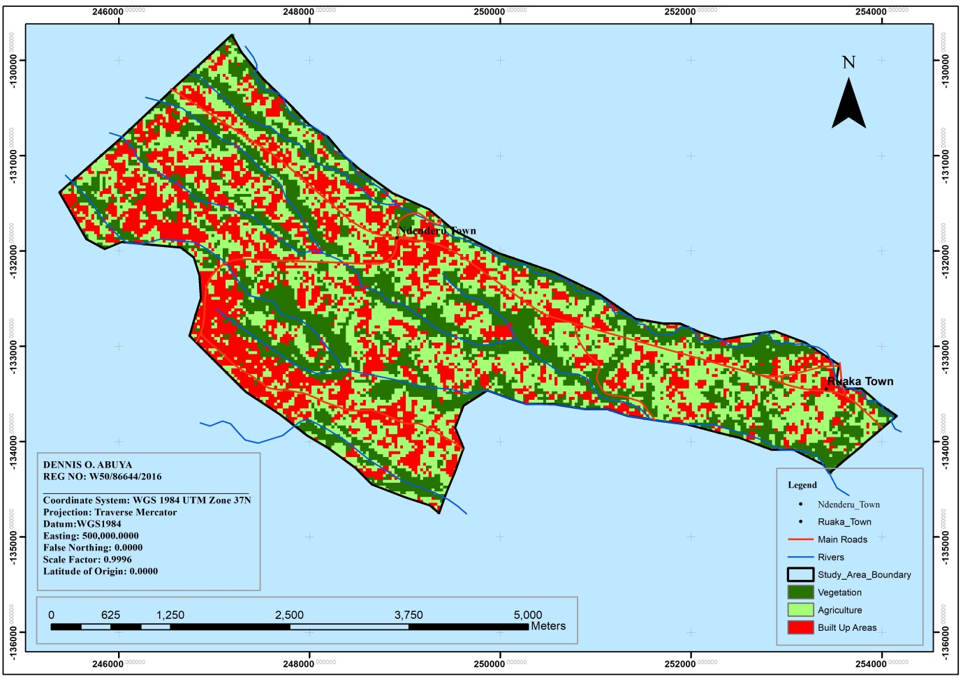 | Map 6. Land Use Changes 1999 |
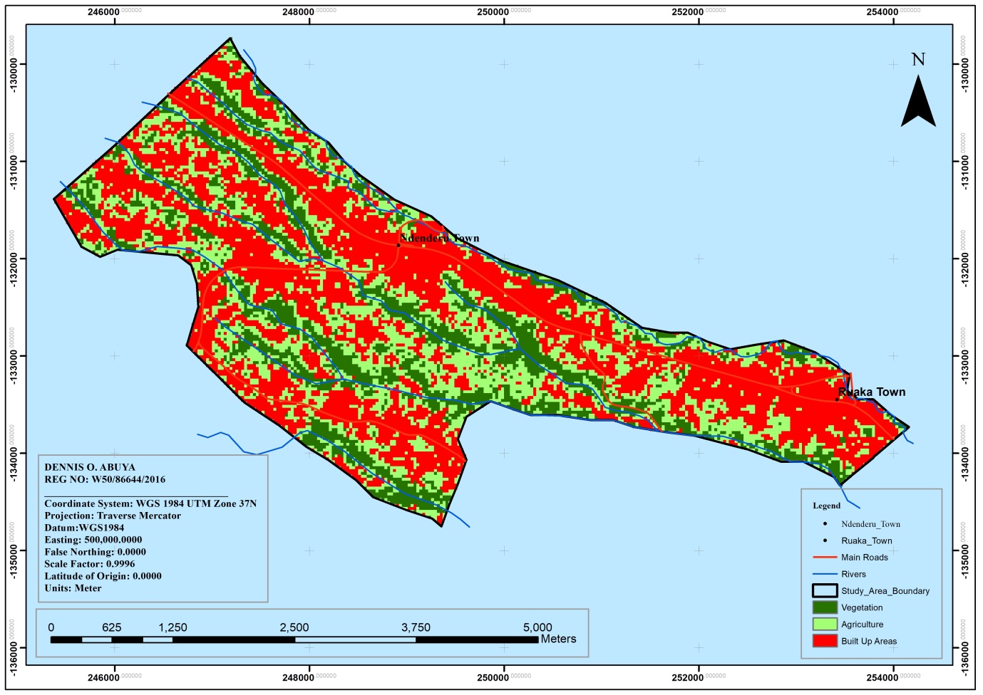 | Map 7. Land Use Changes 2010 |
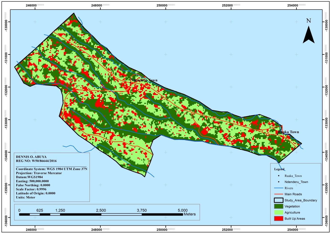
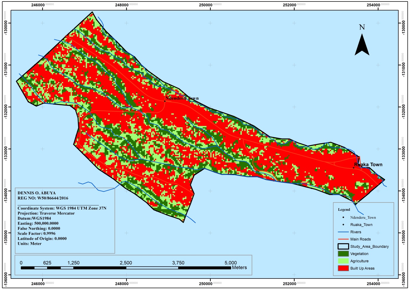 | Map 8. Land Use Changes 2019 |
8. Conclusions
- Research findings reveal that increased population growth, market forces, urbanization and close proximity to Nairobi city are the key drivers of land use changes. These drivers have resulted in rapid land use conversions and fragmentation with little efforts to provide commensurate infrastructure to support the increased demand and capacity. The impacts have resulted in narrow roads and unpaved roads without any provision of NMT facilities and storm water drainage management, traffic congestion with increased private car ownership, lack of terminal facilities, increased boreholes, water contamination and encroachment to water reservoirs, use of unconventional onsite treatment methods for liquid waste such as septic tanks as well as weak institutional capacity to manage urban infrastructure. These have effects on the inadequacy of the infrastructure capacity with the growing population. It is therefore important to evolve a management strategy to unravel the adverse effects of the land use changes on urban infrastructure capacity systems notably roads, water supply, and wastewater infrastructure systems to promote land use change-resilient infrastructure and realize sustainable urban growth.
9. Recommendations
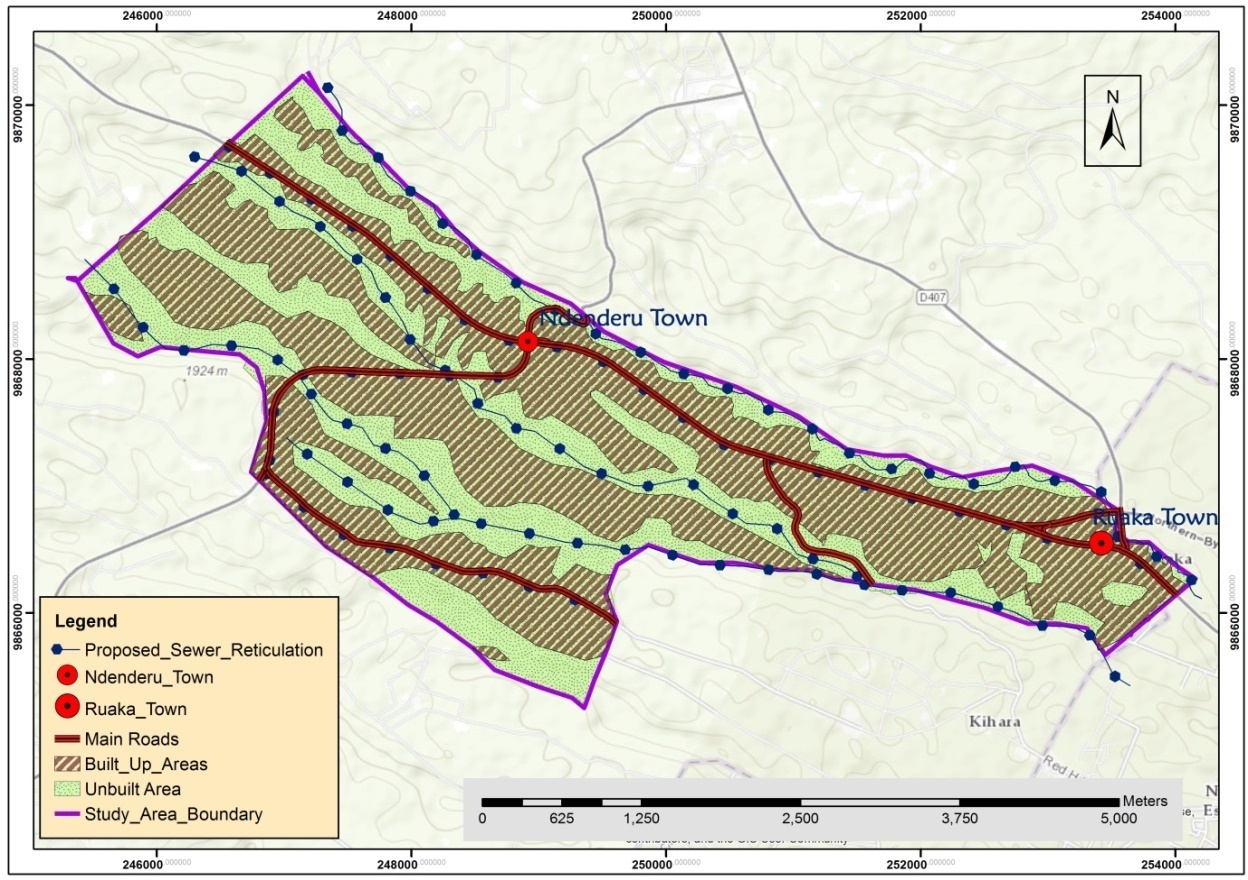
- Sustainable urban infrastructure demands urban management, system efficiency and infrastructure capacity solutions that can address the needs of the communities living in Ruaka. Management of land use changes will address the urban infrastructure capacity challenges and promote land use change-resilient urban infrastructure hence realize the sustainable urban growth in Ruaka Town.Lessons learnt from best practices were used to make recommendations and evolve a management strategy that contains the urban infrastructure capacities. a. Management of Roads Infrastructure Promoting Transit Oriented DevelopmentSustainable transport systems should encourage integration as opposed to segregation of land uses that support Transit Oriented Development. All the areas should be well served with roads and all missing links opened up as illustrated in Map 9 below.
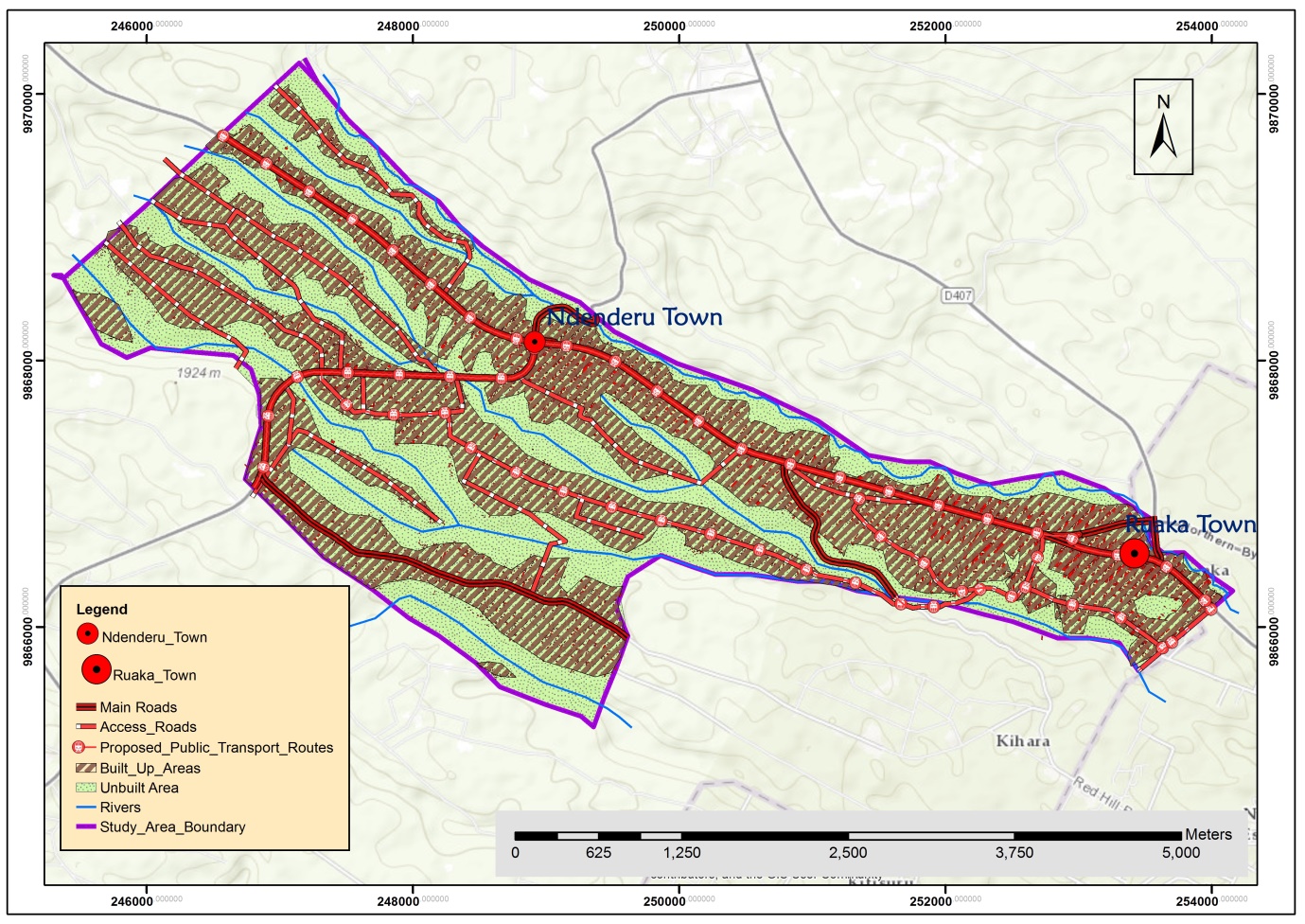 | Map 9. Roads Infrastructure Management Plan |
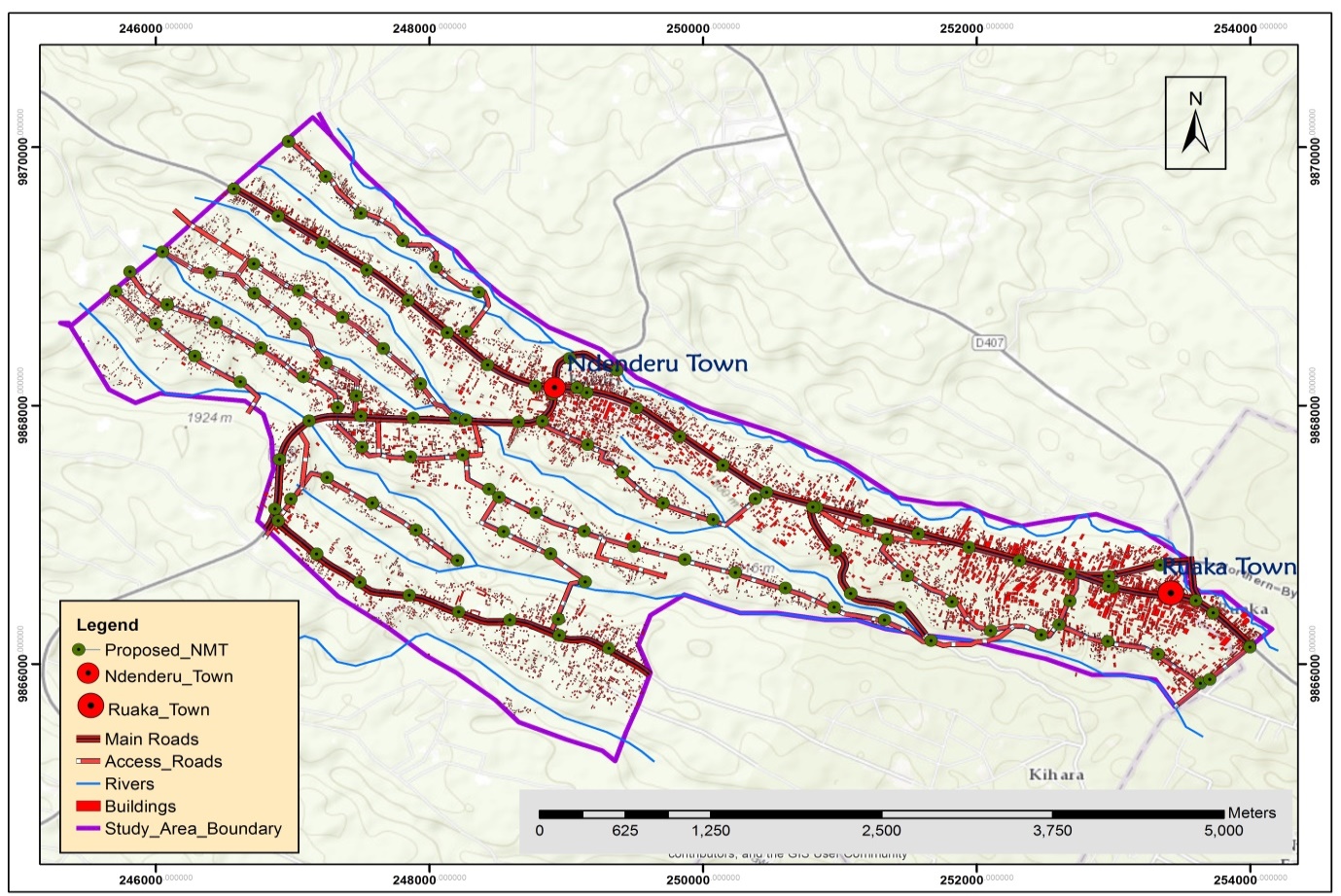 | Map 10. Non-Motorized Transport Management Plan |
 | Map 11. Stormwater Management Plan |
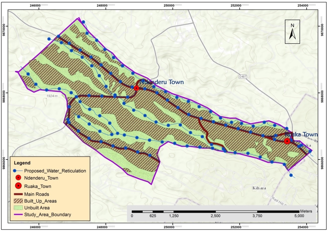
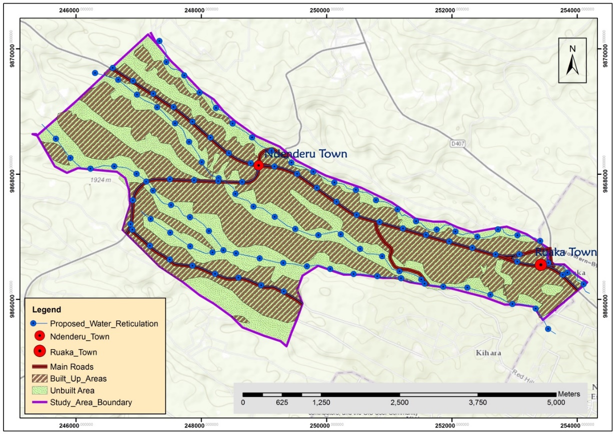 | Map 12. Water Reticulation Management Plan |
 | Map 13. Conservation and Riparian Reserve Management Plan |
 | Map 14. Sewer Reticulation Management Plan |
10. Evolution of an Urban Infrastructure Management Strategy
- i. Technical DimensionRoad infrastructures such as Limuru Road and Western Bypass and Northern Bypass within the study area are interconnected within the study area and across the adjoining Nairobi County jurisdictions. Although Limuru Road, Northern Bypass and the proposed Western Bypass have been built in different periods of history, some out of different sizes and conditions such as the Limuru Road with many potholes, there must be a concern of upgrading, repair and interconnection to the areas that are experiencing such rapid land use changes. Interoperability of these roads between takes place across Nairobi County and Kiambu County’s jurisdictions platform although they are part of the same Nairobi Metropolitan agglomeration. These roads are of different classes and are of different limited capacity such that the access roads which are very narrow can only accommodate a limited number of cars. It is important that managers introduce single routes which will not be used as dual carriageways within the settlement areas. If uncontrolled and unmanaged, the limited capacity of vehicles might crunch their capacity or bring up snarl-ups. The entire road network should be managed with alternative exit points such that if there is a failure in one end or there is an inefficiency, it doesn’t extend to the road network system. The links and interfaces between different roads classes such that of there is an accident at some point of the road, it doesn’t affect the rest of the system or interrelated links such as Red-Hill road or other roads leading to different parts. The urban road network systems should be integrated with multi-modal passes. In addition, the coordination should be done by one agency with several transport lines. Management of transportation in Ruaka should ensure high-frequency departures which run day and night with regular targeted fare reductions. The management should also ensure that future developments are built around the public transport lines such as Limuru road or within walking distances to public amenities and shopping areas such as Ruaka Square, and Ndenderu shopping centres. Traffic monitoring systems should be installed in Ruaka and Ndenderu areas for the success of the proposed integrated public transport system. The benefits gained from such efficient and integrated transport system shall attract investors, businesses and growth in the economy in Ndenderu Ward. Water resources should have integrated water resource management systems with the diversification of water supply, expanding and building water reservoirs with the current proposed reservoir outside the study area boundary in Muchatha area, management of water demand through pricing, enforcement on water conservation measures, importation of water and desalination of borehole water. ii. Economic DimensionUrban infrastructure in Ruaka Town such as Limuru road, Northern Bypass and Western Bypass are long term investments that require huge sunken costs which might be difficult to recuperate since they are a public good investment for economic development and prosperity of the town. As a result, such investments are not be produced for commercial purposes but as public services which no economical rational enterprise will be willing to provide as they might not be paid for. There is a need for economies of scale so that the costs and infrastructure services along these roads are used optimally. Management of these roads should be done in the most efficient way with minimal wastes. Road cutting, alteration and any other unauthorized modifications should be minimized. There are instances where private developers cut the roads without reinstating their status to the original state and this should be controlled. Management should also be tagged on profitability to ensure infrastructure services provided are profitable to develop further services and therefore they should generate profit to invest in better technologies to better treat the roads through maintenance or repairs. Subsidies received from some of these infrastructure services should be utilized in a better way.Ruaka town should use a progressive water tariff structure that penalizes the inefficient use of water for domestic water consumption that exceeds 40m3 per month for residential areas to ensure better utilization of water resources. The water management companies should undertake regular monitoring of water infrastructure to ensure the maintenance of existing water supply infrastructure as opposed to building more or expanding the infrastructure. The management of urban infrastructure should ensure earlier identification of aging infrastructure or approaching the end of the design life and retrofit it or build new resilient urban infrastructure. The high rate of monitoring to increase detection in rates and areas of blockages to ensure that they are accurately registered. Water management companies should use modern technologies such as the water pressure management technology in the management of its water resource through Public-Private Partnership. The advanced water pressure reduction installation plant reduces the water pressure during the off-peak hours and at night which reduces leakages. This reduces the amount of water wastage significantly.iii. Environmental DimensionRuaka town and the entire Ndenderu ward being an urban area is a big polluter from the waste generated from the households and commercial areas. Management of waste infrastructure should be done in the least polluting way through the use of technology such renewable approaches, introduction and connection of sewerage system to the entire ward as opposed to the current unsustainable septic tanks. There is a need to identify assets likely to suffer in case of future urban expansions and other vulnerabilities and provide solutions to curb such menaces. Management of roads and transport infrastructure should create solutions which enhance environmental conservation, reduce emissions and pollutions such as the use of non-motorized transport and pedestrianization of some of the streets in Ndenderu ward.iv. Social DimensionWater tariffs should be provided in a socially equitable way through social tariffs which are favourable to the customers across all social classes. Water is a basic right, it should be provided at an affordable cost where affordability should be relative to the income levels of the people in the area. This should be done in a way that they don’t end up spending all their income on water and transportation. Water supply should be developed and supplied to the entire Ndenderu ward without discrimination other sections of the ward. Currently, the water supply infrastructure is only done within the Ruaka CBD area and the rich suburbs where the residents may have the capacity and voice to control or protest decisions of failure to supply of water. Community boreholes accessed by the residents should be constructed to supplement the current water supply. It is vital to use non-discriminating approaches in the provision of urban infrastructure. Infrastructure provision such as the roads, sewer and water reticulation should have high service coverage of the entire ward. There is a need to involve the public in the implementation of all infrastructure projects for public acceptance and confidence through a public engagement campaign to educate the public on the stringent process of infrastructure production. This enables them to know how to maintain such infrastructure such as the roads, water reticulation networks and how to maintain water safety for drinking. The transportation and roads management system should be able to address the social needs by making transportation and road networks accessible, safe and secure and should be carried out in an equitable manner to accommodate the disadvantaged groups such as the people with disabilities, women and children. This can be achieved through multimodal transport that focuses mainly on non-motorized means of transport which encourages social groups and interaction with the presence of street furniture, safe public spaces and conducive environment. Streets in Ndenderu ward should be redesigned to regulate and encourage low-speed limits to encourage the non-motorized means of transport and pedestrian use hence enhancing the safety of such road users within Ruaka and Ndenderu towns. v. Jurisdictional DimensionPolitical factors have influenced LUC especially on policy matters and particularly on zoning regulations which have been changing over different political regimes and hence affect the decisions made on the nature of developments, plot rations and ground coverages used in approval and implementation of plans in Ruaka and Ndenderu Ward in specific. Operation of Limuru Road, Western Bypass, Northern Bypass, and Water Supply systems in Ruaka is across political and legal jurisdictions of National Government, Nairobi County and Kiambu County which poses technical challenges of interconnectivity and interoperability. There is a demand for more reliability of the water supply, maintenance of the Limuru Road which has many potholes. There is a need for coordination and collaboration between the National Government agencies including KURA, KeRRA, KeNHA and Kiambu County. Therefore, Ruaka urban infrastructure management systems can only be successful through urban management strategies, institutional reforms and sound urban governance through political and government commitment to infrastructure projects. Strong political will and effective regulatory and legislative frameworks should be put in place to enhance strict enforcement of the legislation, ensure proper management of roads, water supply and wastewater infrastructure. It is also essential to ensure there are collaboration and sensitization of its stakeholders to enhance transparency and accountability of the projects and programmes in place. Implementation StrategyThe implementation of the plan shall be as done as provided in the implementation matrix Table 5 Below.
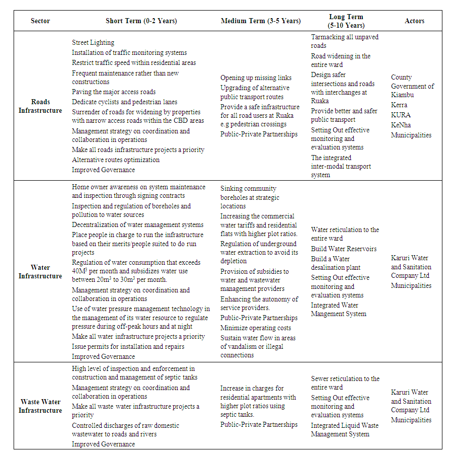 | Table 5. Implementation Matrix |