-
Paper Information
- Paper Submission
-
Journal Information
- About This Journal
- Editorial Board
- Current Issue
- Archive
- Author Guidelines
- Contact Us
American Journal of Geographic Information System
p-ISSN: 2163-1131 e-ISSN: 2163-114X
2019; 8(3): 119-125
doi:10.5923/j.ajgis.20190803.01

Appropriateness of Handheld Garmin GpsMap 76csx in Urban Tree Inventory
 Abstract
 Reference
 Full-Text PDF
 Full-text HTML
Raphael Gikunda 1, Cameron S. Griffith 2
1Texas Tech University, Lubbock, TX, USA
2Department of Geosciences, Texas Tech University, Lubbock, TX USA
Correspondence to: Raphael Gikunda , Texas Tech University, Lubbock, TX, USA.
| Email: |  |
Copyright © 2019 The Author(s). Published by Scientific & Academic Publishing.
This work is licensed under the Creative Commons Attribution International License (CC BY).
http://creativecommons.org/licenses/by/4.0/

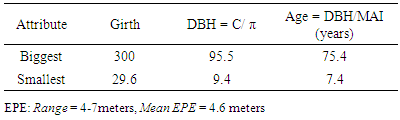
This study was intended to ascertain the suitability of Garmin GpsMap 76csx for use in urban tree inventory. The inventory involved the use of a GPS receiver, Garmin GPSmap 76CSx, and a diameter tape. Data were collected from 85 honeylocust trees and analyzed using ArcMap (average nearest neighbor tool) and a conventional method of estimating age. A map was generated in ArcMap to aid the examination of tree positional accuracy. The results indicate that most honeylocust trees were planted around the administration and Agriscience buildings, the Commons Food Court and near the corner along 19th street. The trees exhibited statistically significant clustering patterns (p <.05, Z =-5.28) and the Estimated Position Error (EPE) ranged from 4 to 7 meters with a mean of 4.6 meters. This show that the device was fairly accurate in locating the trees. The largest honeylocust tree had a girth of 300cm, DBH of 95.5cm and about 75 years old while the smallest measured 29.6 cm in circumference, DBH of 9.4 cm and about 7 years old. GIS/GPS integration in conventional tree data collection methods helps in generating valuable information that boosts the management of the urban forest. Garmin GpsMap 76csx is suitable for trees in an urban environment. The device is more effective with slightly lower EPE values when most trees have shed leaves (autumn) so as to minimize multipath errors resulting from the canopies.
Keywords: Geographic Information System, Global Positioning System, Honeylocust, Spatial distribution, Tree inventory
Cite this paper: Raphael Gikunda , Cameron S. Griffith , Appropriateness of Handheld Garmin GpsMap 76csx in Urban Tree Inventory, American Journal of Geographic Information System, Vol. 8 No. 3, 2019, pp. 119-125. doi: 10.5923/j.ajgis.20190803.01.
Article Outline
1. Introduction
- The ecological role of trees within an urban and learning environment is now widely recognized (Nowak et al. 2007:22) as they improve air quality, reduce temperatures in warm climates, cleanse the particulate air pollution and create outdoor learning environments. This project involves an inventory of honeylocust trees on a section of Texas Tech University. According to Blair (1990:358) honeylocust (Gleditsia triacanthos L.) is a medium to large-sized tree belonging to the legume family. A mature tree can attain a diameter of 30 inches and a height of 80 feet. The tree grows well in a range of soils and environments. Its wood is compact, firm, coarse-grained, strong, rigid and lasts long even when in contact with the soil. Other than wood, the tree can be planted as an ornamental or to produce pods for livestock feed. Texas Tech University campus has an estimated population of about 8,000 trees that have planted over the years as part of the beautification program. Just recently, one of its honeylocust trees was crowned the largest tree in the state of Texas. The tree had a height of 56 feet and a crown of about 77 feet (Sims, 2015). It is characterized by small, greenish-yellow blossoms and a honey-like substance in its pods. Tree diameters are measured at DBH (diameter at breast height), which is 4.5 feet above the ground. Miller (1997:105) argued that the management of any resource needs to begin with an inventory of that resource. Therefore, an inventory of honeylocust in the university is core to its management. Tree inventories vary from simple to complex depending on the goals and may involve important tree attributes such as species, size, tree location, site characteristics and tree conditions (Wood 1999:11). This study involved measurement of DBH, estimation of age and tree locations. Tree DBH measurements are beneficial in the selection of trees with healthier growth form (Nabeshima et al. 2010:1055). Baston and Hasegawa (2013:613) indicated the global positioning system (GPS) has become an essential device in tree inventory and in the advancement of precision forestry. Long et al. (2008:7) observed that a tree inventory forms a foundation for formulating a plan developing and preserving quality environs for life. Research has shown that GPS and geographic information system (GIS) technology have made it easier to locate trees compared to previous methods such as simple diagrams, maps and aerial photographs which were time-consuming and very expensive (Kane et al. 1998:135). Since the device was designed for use in open sky situations the tree canopies limit its use in forestry. Tree canopies and trunks increase error and interfere with the reception of the signal broadcast by the satellites (Baston & Hasegawa 2013:613). The university population is on the rise and the buildings are being erected on spaces that had been previously occupied by trees. Honeylocust tree inventory would help determine the need to plant more, reduce its population and also determine the true value of the tree resource and the benefit it provides (Wood 1999:14).Purpose and ObjectivesThe purpose of this study was to ascertain the appropriateness of Garmin GpsMap 76csx for use in urban tree inventory. The study took stock of honeylocust trees planted on the southern part of the campus using a GPS receiver and tape measure. The specific objectives were to; i. Describe the spatial distribution of the honeylocust trees in the university campus ii. Ascertain the suitability of Garmin GpsMap 76csx for use in the urban tree inventoryResearch Questions The research questions that the study envisioned to address were;i. Is the distribution of the honey locust trees at Texas Tech University campus random, clustered or dispersed?ii. is Garmin GpsMap 76csx suitable for locating trees in an urban environment?
2. Literature Review
- Honeylocust (Gleditsia triacanthos)Trees play a vital role in reducing air pollution levels by trapping contaminants, obstructing small dust particles, and discharging oxygen (Nowak & Crane 2002:381). The role of the street tree has transitioned from one of beautification and ornamentation to one of environmental service provision over the course of the last 30 years (Sims 2015). Empirical evidence shows that honeylocust tree is very hardy and tolerant of drought and salinity, it is widely planted for windbreaks and soil erosion control (Blair 1990:358). Gallery (2017:44) noted that the tree commonly found in urban landscapes and along city streets, it is characterized by a narrow trunk with light grayish brown bark, tiny delicate green leaflets, and a pleasing pyramidal shape. According to the Blair (1990:358) the tree is widely planted in East and Central United States and achieves maximum growth in valleys of small streams. Among the honeylocust tree species, the thorn-less is widely grown as an ornamental and shade tree in all countries having a template climate. The tree doesn’t do well in gravelly and clay but in Alfisols, Inceptisols, and Mollisols soils and in places with elevations ranging from 610 to 760m. On the tree’s life history, the author notes that flowering occurs in late spring, fruiting takes place in mid-September, seed-bearing occurs between the ages of 10 years and 100 years. Blair further points out that naturally, honeylocust tree attains a height of 21 to 24 m and its mean height growth in Texas is 49cm.Tree Inventory A study by Smiley and Baker (1988:36) outlines management as the major reason for a tree inventory among other reasons which includes budget, increasing work efficiency, education, and public information. The scope of the inventory is determined by the needs and goals of the individual or organization undertaking the exercise. Gering (1995:177) observed that DBH is a tree characteristic that is included in many tree inventories because it is an easily measured variable that is related to the amount of growing space occupied by a tree and it is often used to determine the volume of a tree. This was reiterated by Turan (2009:215) who pointed out that stem DBH is an important tree characteristic used to accurately predict tree dimensions.Handheld GPS and Tree Location Measurement Empirical evidence shows that GPS has the potential of collecting coordinates in a forest environment with variable degrees of accuracy (Edson & Wing 2012:567). A study by Owari et al. (2011:105) used a handheld GPS receiver to mark trees in a single-tree selection management system. The survey involved 1565 trees planted on a 29.23 hectares plot at the University of Tokyo. About 43 marked coordinates were surveyed to examine the positional accuracy. The analysis revealed an average positional accuracy of 5.7 meters. The findings propose that GPS receiver can be used to improve the accuracy of forest data gathering processes resulting in better policies that can boost forest resources management. Besides, accuracy, GPS helps to preserve previous harvest data and boost the standards of tree marking practices. It would have been interesting to see a discussion of the GPS errors that may have been involved. Owari et al. (2011:105) observed that at least four satellite signals are required by GPS receiver to fix a location of the trees. Sigrist et al. (1999:3595) posit that a constrained view of the sky in a forest environment compromises the tree positional accuracy. Zandbergen and Arnold, (2011: 883) argue that GPS accuracy is influenced by factors such as satellite position, atmospheric conditions, noise in the radio signal and natural barriers like building and trees. However, Sigrist et al (1999:3595) noted that there are several techniques that can be adapted to improve the accuracy of GPS measurements in a locating tree namely differential GPS (DGPS), real-time kinematic (RTK) GPS or Assisted GPS. A study by Zandbergen and Arnold (2011:883) found that the accuracy of the GPS receiver depends on the prevailing conditions. Research has also shown that Position Dilution of Precision (PDOP) is more often used for representing the accuracy of a GPS position, is higher under tree cover. The lower the value the higher the accuracy and vice versa. Weih et al. (2009:163) also discuss sources of errors that may compromise the accuracy of the receivers. Of those mentioned, the tree and building multipath errors are the main barriers to the receivers' accuracy.Theoretical Framework This study was rooted in Holling’s (1973) ecological resilience theory. The theory describes a resilient ecology as the amount of disturbance that an ecosystem could withstand without changing self-organized processes and structures. As a result of the growth of students in the university, new structures have been erected to ease pressure on the existing ones. This, therefore, calls for an inventory of the ecosystem components with a view of identifying opportunities and actions likely to increase resilience across the whole campus landscape. As such the honeylocust trees in the campus can be best managed on the basis of their stock information. The desired outcome of resilience analysis is actions that will restore lost resilience, or enhance it to allow a greater array of safe resource-use options. Ernstson, et al., (2010) argued that resilience declines, systems are exposed to greater risks, uncertainties, and surprises; it often takes progressively smaller shocks for that system to lose its capacity to sustain a certain regime.
3. Methods
- Study Area The study was conducted at Texas Tech University main campus; the largest institution of the Texas Tech University System. The university is located in Lubbock, Texas with a geographic coordinates 33.5843° N, 101.8783° W. The main campus sits on a 1,839-acre piece of land with a population of over 36,000 students. The university also operates a Research Center-East Campus (Lubbock), Farm at Pantex (Texas Panhandle), research facilities at Reese Technology Center (west of Lubbock); agricultural field laboratories at New Deal, University Center at Junction and off-campus educational sites at El Paso, Fredericksburg, Highland Lakes, Hill College, Waco, and Collin (Texas Tech University, 2018). Due to lack of adequate time to collect data in all parts of the university, the study focused on the southern part of the university. This part was chosen because of its closeness to the city and the need to cleanse particulate air pollution. Data Collection and Analysis The study focused on three main attributes namely tree location and diameter breast height (DBH). Data collection exercise involved the use of Garmin GPSmap 76CSx receiver and a tape measure. GPS receiver was initialized and set at UTM coordinate system, WGS 1984 datum, and units in meters. Tree locations were collected by use of a handheld GPS receiver as waypoints. In order to enhance the accuracy and reliability of position estimates, the receiver’s Wide Area Augmentation System (WAAS) was enabled. GPS receiver was also held away from the body to ensure that the GPS antenna has an unobstructed view of the sky, although this was difficult to achieve in most cases because of the tree canopies. The collected GPS waypoints were uploaded to a computer for a spot check to ensure data accuracy.The study covered 85 honeylocust trees which were identified and recorded as 001 to 085. In order to estimate the age of the trees, the DBH of each tree was measured at a height of 4.5 feet (1.37m) by use of a diameter tape. It is measured by use of a calibrated diameter tape that shows the width measurement when wrapped around the girth of a tree. Conversion of girth measured in centimeters to diameter is achieved by dividing girth by π (White 1998:2)C = π * DBH, therefore DBH= C/ π: Where: C = Circumference of tree, π = 3.142, DBH = Diameter Breast HeightThe age of the tree was estimated by dividing Diameter Breast Height (DBH) with the Mean Annual Increment (M.A.I). The formula applied to estimate the age of the tree is as follows; A = DBH / M.A.IWhere: A = Age of tree, DBH = Diameter Breast Height and M.A.I = Mean annual increment. The mean annual increment (MAI) of honeylocust under favorable conditions from 0.33 to 0.50 inches (1.27cm) (Blair 1990:361) while the mean height growth is 24 inches per year (Mat et al. 2014).
4. Results and Discussion
- The study focused on locating honeylocust trees, analyzing their spatial patterns, estimating their ages and determining the suitability of GpsMap 76csx in tree inventory.Location of Honeylocust Trees The first objective sought to locate honeylocust trees on the southern part of Texas Tech University campus using GPS. Honeylocust tree locations collected as waypoints were uploaded to a computer and imported to ArcMap to create a map. A map was made to illustrate the distribution of honeylocust trees located on the southern part of the campus (see Fig. 1). The GPS tree locations were plotted on an open street base map for a visual examination of the accuracy. The results indicate that most honeylocust trees were planted around the administration and Agriscience buildings, the Commons Food Court and near the corner along 19th street. The honeylocust trees planted on the southern part of the administration building were the oldest (Table 2). The oldest among the sampled trees was about 95 years. Blair (1990:358) reported that a honeylocust tree has a short life with the oldest attaining about 125 years.
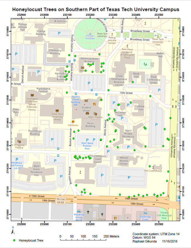 | Figure 1. Distribution of Honeylocust Trees on the Southern Part of Texas Tech University Campus |
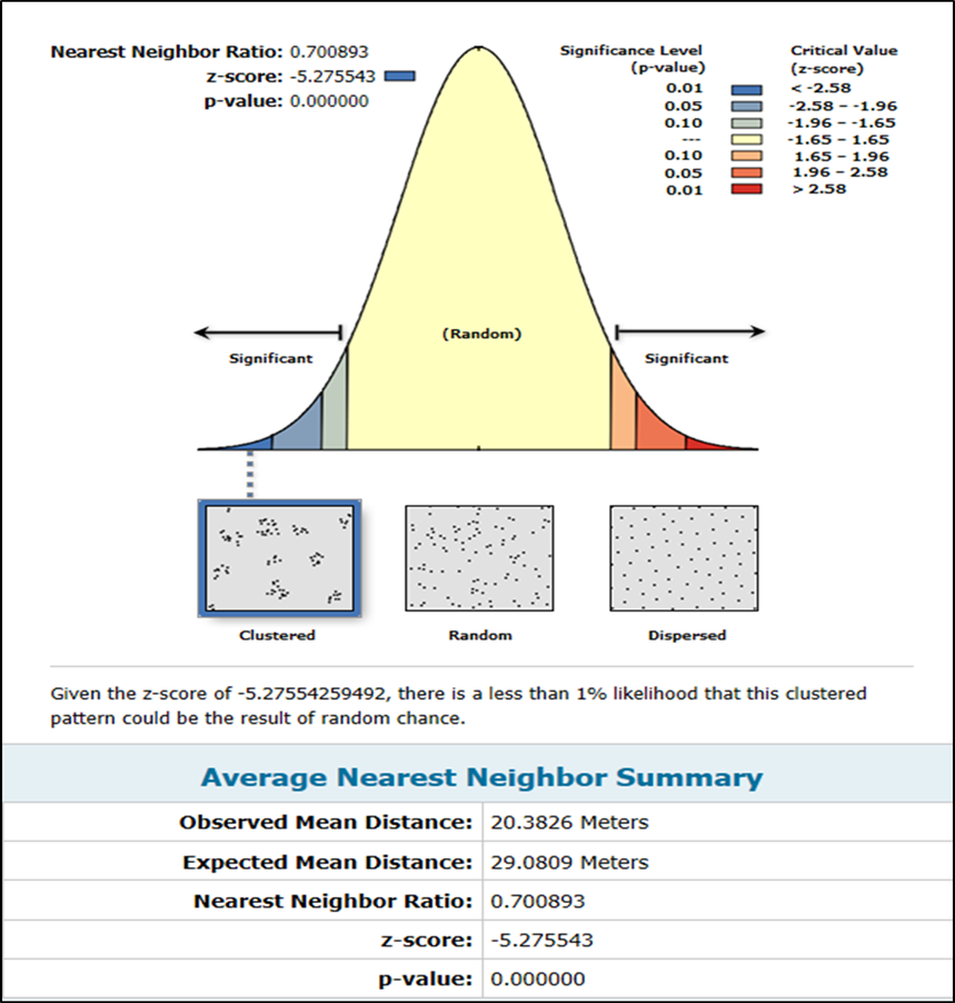 | Figure 2. Spatial Patterns of Honeylocust Trees at Texas Tech University |
|
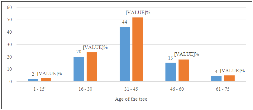 | Figure 3. Distribution of Honeylocust Trees by Age (N=85) |
5. Conclusion and Implications
- Management plans to sustain or enhance healthy honeylocust tree cover will be most successful when they incorporate local tree data and consider relevant local social and ecological factors, costs and associated ecosystem services. GIS/GPS integration in conventional tree data collection methods helps in generating valuable information that boosts the management of the urban forest. The study confirms the suitability of Garmin GpsMap 76csx in urban inventory due to minimal EPEs witnessed. Its use during autumn in temperate and at the onset of dry seasons would enhance its precision and accuracy as many trees will have shed leaves hence minimizing multipath errors. GPS tool enabled integration of classical tree data (girth & DBH) and spatial data for the generation of a map to ease visualization of results thus adding value to the tree inventory process. A GPS receiver is a highly time-efficient and convenient way of mapping trees because of the lower degree of precision associated with it. Clustered honeylocust tree patterns were apparent due to the presence of buildings which would not allow a uniform distribution. A majority of the honeylocust trees in the university campus are young (less than 45 years old).Dense tree canopy greatly reduces the accuracy of the GPS locations due to the reflection of signals. Therefore, it is advisable to collect tree positions at a time when they have shed the leaves and during a clear sky to minimize the positional errors. It is evident from the findings that estimated positional errors were significantly reduced by enabling the WAAS on the GPS receivers. However, it is difficult to eliminate all the errors especially multipath errors in a forest environment because of the tree canopies and branches. A confirmation of the argument advanced by Kos et al. (2010:399) that most errors influencing positional measurements can be fully eliminated or substantially reduced using differential measurement techniques. Of all the errors multipath was the dominant error that affected GPS positioning accuracy. This study covered honeylocust trees planted on the southern part of the campus thus, a study covering the other parts of the campus including the other species of trees could boost care and maintenance of the trees on the campus.