Ahmed El Shouny1, 2, Essam M. Al-Karagy2, Hoda F. Mohamed2, Gomaa M. Dawod2
1King AbdulAziz University, Department of Geomatics, Faculty of Environment Design, Jeddah, Saudi Arabia
2Survey Research Institute, National Water Research Center, Giza, Egypt
Correspondence to: Ahmed El Shouny, King AbdulAziz University, Department of Geomatics, Faculty of Environment Design, Jeddah, Saudi Arabia.
| Email: |  |
Copyright © 2018 The Author(s). Published by Scientific & Academic Publishing.
This work is licensed under the Creative Commons Attribution International License (CC BY).
http://creativecommons.org/licenses/by/4.0/

Abstract
Geoid modelling is a fundamental procedure in geomatics and geosciences applications to estimate the orthometric heights from the ellipsoidal heights measured using Global Navigation Satellite Systems (GNSS) observations. In case of no local geoid model is available for any area, a Global Geopotential Model (GGM) is utilized for height conversion. However; the availability of too many GGMs, more than 160 models, makes the selection of the most acceptable one is a significant task. This paper aims to develop a straightforward scheme to acquire, manipulate, and investigate the accuracy of GGMs, within a Geographic Information Systems (GIS) environment. Four GGMs, namely XGM2016, GECO, EIGEN-6C4, and EGM2008, have been utilized in Egypt. Accomplished results show that the standard deviations of the investigated GGMs' discrepancies, over Egypt, range from ± 10.90 mGal to ± 13.10 mGal for gravity anomalies, and from ± 0.23 m to ± 0.30 m for geoid heights. In order to pick up the optimum GGM, a dimensionless reliability index is computed for each GGM. Based on the investigated GGMs, the available datasets, and also the proposed criteria applied in analyzingresults in this paper, we can conclude that the EGM2008 is still the most suitable GGM for representing the gravitational field over Egypt with an average reliability index of 5.10. The proposed efficient GIS-based process is practically beneficial for height conversion in several geodetic, environmental, surveying, and mapping applications in Egypt.
Keywords:
GGM, Geoid, Gravity, GNSS, GIS, Egypt
Cite this paper: Ahmed El Shouny, Essam M. Al-Karagy, Hoda F. Mohamed, Gomaa M. Dawod, Gis-Based Accuracy Assessment of Global Geopotential Models: A Case Study of Egypt, American Journal of Geographic Information System, Vol. 7 No. 4, 2018, pp. 118-124. doi: 10.5923/j.ajgis.20180704.03.
1. Introduction
Civil and surveying engineers deal with three fundamental surfaces of the Earth and; consequently, several types of heights. These surfaces include the terrain or physical surface, geoid or the true irregular equipotential surface of the Earth, and the ellipsoid or the most nearest regular mathematical surface to the geoid. The ellipsoidal height is measured from an ellipsoid, while the orthometric height is based on the geoid. The vertical separation between these both surfaces represents the geoid undulation or geoidal height. Hence, geoid modelling is needed for transforming the ellipsoidal heights, related to the ellipsoid surface, estimated from (GNSS) measurements into orthometric heights, related to the Mean Sea Level (MSL), which obtained using levelling works. This transformation is necessary because the important needs of this orthometric heights in topographic maps, and many other applications in civil engineering. The comparison of (GGM)s over a spatial region is crucial to choose the most suitable one to be used in geoid modelling [1]. In addition, the availability of more than 160 GGMs currently makes the assessment of their performance in representing the gravitational field over a selected area is essential, e.g., Japan [2], and Argentina [3]. In Egypt, geoid modelling and different (GGM)s evaluation have been tremendously investigated in the last couple of decades, e.g. [4] and [5]. Number of researches has utilized Geographic Information Systems (GIS) in geodetic applications in general, and in geoid modelling in particular. GIS-based raster analysis has been used to improve the GGM-derived geoidal heights through linear sharpening the original raster representation of the models [6]. [7] Investigated the possibility of developing a local geoid model by evaluating several GGMs within a GIS environment. However, this study used GIS just to compare the results obtained from an online service for point-by-point geoid calculations, which is not the case of the present study. Over a small spatial region where little number of known GNSS/levelling points are available, GIS could be used, first, to build a local geoid model, and then to interpolate geoidal heights at other unknown GNSS stations to estimate their corresponding orthometric heights [8] and [9]. The International Center for Global Earth Model (ICGEM) organization, recently, starts an online service to compute many geoidal properties and deliver them in a grid format [10]. Based on that precious service, the assessment of GGMs utilizing national geodetic data could be carried out, solely, by GIS. The main objective of this paper is to develop a simple scheme to acquire, manipulate, investigate the accuracy of GGMs over Egypt region, to determine the most appropriate model and enhance its precision, completely, within a GIS environment. This work can be considered as an extra GIS-based geodetic application for height conversion in Egypt.
2. Global Geopotential Models
GGMs have been developed since 1960s to express the gravitational potential of the Earth (V) into a series of spherical harmonics as: (for more details, refer for example to [11])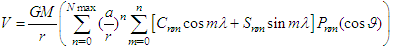 | (1) |
where: GM is the gravitational constant, r is the radial distance, a is the equatorial radius of the Earth, θ and λ are the latitude and longitude respectively, Jn are the zonal harmonics, those contain the Snm and Cnm are the tesseral harmonics, Pnm are the associated Legendre coefficients n and m are the degree and order of the geopotential model, and Nmax is the maximum degree of the model. The geoidal undulations or geoidal heights (N), representing the difference between the geoid and ellipsoid surfaces, can be evaluated through two methods based on available geodetic measurements. First, it can be computed through the well-known Stokes' formula, if gravity anomalies are utilized, Ngrav, as: 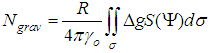 | (2) |
Where: R is the radius of the Earth, Δg is the gravity anomalies, and S (Ψ) is the Stokes' function, and dσ is an infinitesimal surface element on the unit sphere σ. In practice, the geoidal undulation, N, is divided into three components and computed as: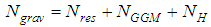 | (3) |
Where, Nres is the geoidal undulation component related to residual gravity anomalies, NGGM is the component related to GGM, and NH is the component related to topography effect. Consequently, geoid modelling requires the utilization of a GGM to represent the global variations or long wavelengths of the Earth gravitational field, along with a Digital Elevation Model (DEM) to depict the topography of the local area and determine its effects on the developed geoid model. The second manner of computing geoidal heights is the so-called GNSS/levelling or the geometric approach, where Ngeometric can be computed from both GNSS-based ellipsoidal heights relative the ellipsoid surface (h) and the orthometric heights related to MSL (H) as: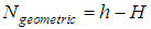 | (4) |
In this paper, four GGMs have been selected for evaluation, namely: Experimental Gravity Field Model (XGM2016), GOCE and EGM2008 combined model (GECO), European Improved Gravity model of the Earth by (EIGEN-6C4), and Earth Geopotential Model (EGM2008). Although the first one is a medium-resolution model, it has a great attention since it would be the basis for the upcoming Earth Geopotential Model 2020 (EGM2020), while the other three GGMs have been selected since they represent high-resolution models with degree and order equal 2190. A brief description of each model is follows:- XGM2016: The experimental gravity model is a GGM up to 719 degree and order, supported by an improved terrestrial global data of 15'x15' gravity anomalies, along with satellite-based gravity data from the Gravity Recovery and Climate Experiment (GRACE) and the Gravity and Ocean Circulation Explorer (GOCE). XGM2016 utilized, in addition, new promising processing methodology [12].- GECO: A global gravity model utilizes the GOCE satellite-based gravity data to improve the accuracy of the EGM2008 GGM in low and medium frequencies. GECO is developed, in 2015, up to degree and order 2190 [13]. GECO is the most-recent published high -resolution GGM until 2017. - EIGEN-6C4: A model released in 2014, that utilizes satellite tracking data (from LAGEOS, GRACE, and GOCE missions) along with a global surface gravity anomaly grid and altimetry data. The model is up to 2190 degree, developed by both the Germany GFZ research center, and the French CNES research center [14].- EGM2008: An integrated GGM developed by the US National Geospatial-Intelligence Agency (NGA) up to 2190 degree. It was developed in 2008 based on GRACE-based satellite tracking data, terrestrial gravity data, and altimetry data. It was a millstone in GGM development, since its preceding model did not exceed 360 maximum degree [15]. The evaluation of equation 2 over a spatial region requires a specific mostly-academic software package, e.g., GRAVSOFT and GRAFIM, prior to apply GIS for modelling and mapping obtained results. However, the handling and assessment of GGMs carried out in this study, is performed, totally, within a GIS environment. The performance of each GGM in representing the gravity field over Egypt is, first, investigated and then, the obtained GGM-based free-air gravity anomalies against the free-air gravity anomalies of the known terrestrial stations (Δg) are compared. At these stations, relative gravity have been measured and tied to the national absolute gravity network, to obtain absolute gravity values. So, the free-air gravity anomalies are computed as: | (5) |
Where: g is the known absolute gravity, H is the orthometric height obtained from precise levelling, γa and γb are the equatorial and polar normal gravity values, e2 is the second eccentricity of the used ellipsoid, and p = (b γb / a γa) - 1, where a and b are the WGS84 semi-major and semi-minor ellipsoidal axis respectively. The second GIS-based comparison step judges the GGM-based geoidal heights against the known GNSS/levelling undulations at the utilized stations in Egypt. Differences in both steps are; consequently, statistically investigated to define the accuracy and reliability of the tested GGMs.
3. Processing and Analysis
The available terrestrial geodetic datasets include (as shown in Fig. 1): The first-order Egyptian national gravity networks of both 1997 and 1977 containing 247 measured gravity points (shown in red dots symbol); and 976 GNSS/levelling stations (shown in green dots symbol) all over Egypt, that were observed by the Survey Research Institute (SRI) in various projects over the last five years. It worth mentioning that the average accuracy of the Egyptian National Gravity Standardization Network of 1997 (ENGSN97) is ± 0.02 mGal; while the corresponding value of the National Gravity Standard Base Network of 1977 (NGSBN77) is ± 0.08 mGal. Although, there are other available second-order gravity measurements in Egypt, particularly in the western desert, their accuracy in both gravity and coordinates are questionable. The utilized GPS/levelling points have been surveyed using the first-order levelling, and the first-order GPS geodetic network standards, and their average accuracy could be estimated as ± (3 – 4) cm. Thus, the most-precise available national datasets have been utilized, herein, to investigate the reliability of the four tested GGMs as will be discussed in details in the next section.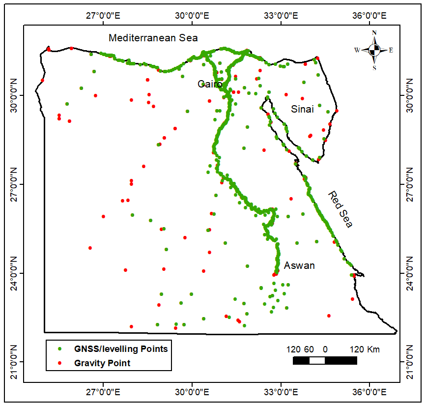 | Figure 1. Available Terrestrial Data |
As stated previously, the ICGEM organization starts an online service to compute many geoidal properties (for some GGM) and deliver them in a grid format [10]. For any GGM, a specified grid could be computed online and downloaded for a variety of geoidal characteristics such as geoid heights, height anomaly, gravity anomaly, and gravity disturbance. Each grid has a gdf format, which can be easily manipulated to be applicable for GIS. Therefore, two 5'x5' grids, for gravity anomaly and geoid heights, have been downloaded for each model of the other three tested GGMs. The interpolated gravity anomaly and geoid undulation values at each control point have been compared against their known values, and their differences are statistically investigated. The ArcGIS 10 software has been utilized, herein, for interpolation and mapping as an example of GIS packages. Figures 2 and 3 depict the gravity anomaly and geoidal undulations for those GGMs.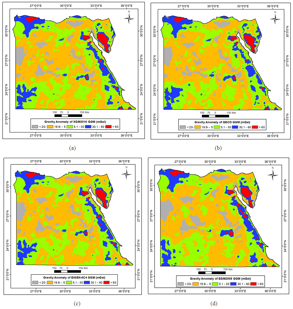 | Figure 2. Gravity Anomaly of: (a) XGM2016, (b) GECO, (c) EIGEN-6C4, (d) EGM2008 Models |
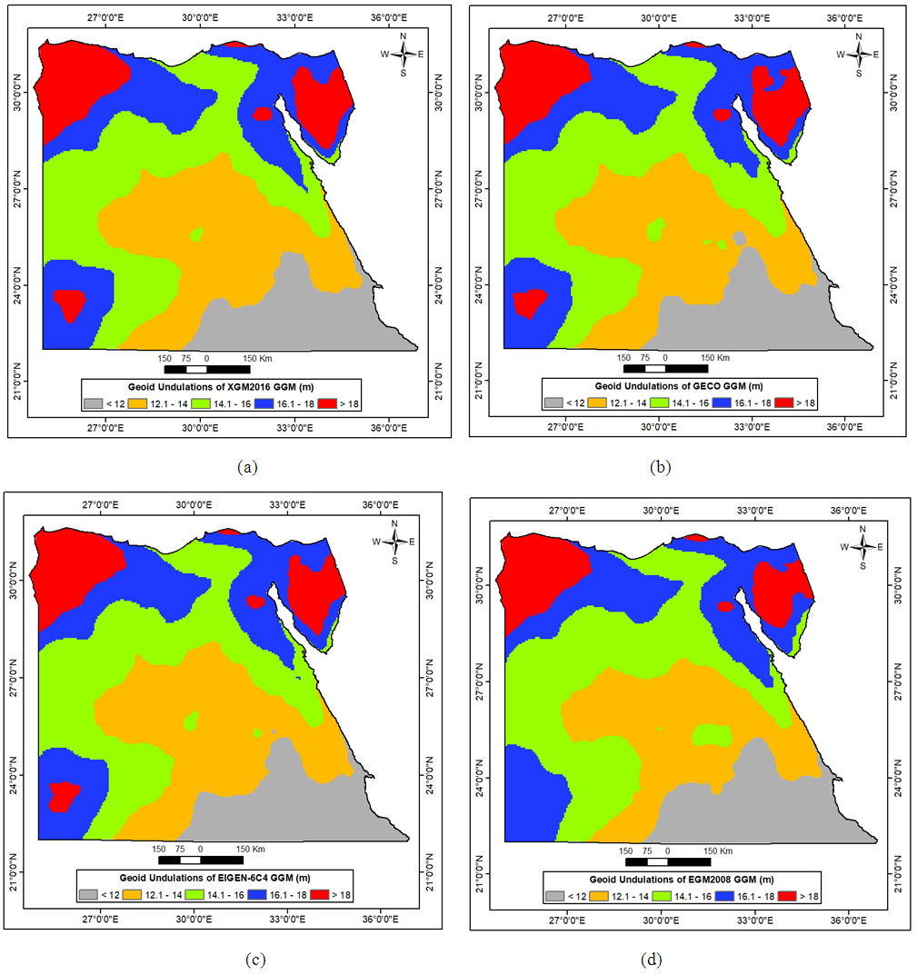 | Figure 3. Geoid Undulations of: (a) XGM2016, (b) GECO, (c) EIGEN-6C4, (d) EGM2008 Models |
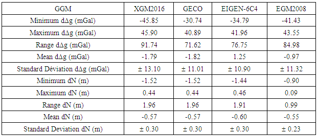
In the next step, the two utilized control point datasets have been used to interpolate the GGM-based gravity anomalies and geoidal heights from each GGM corresponding raster. The Inverse Distance Weighted (IDW) interpolation method has been adopted, since the geoid variations over Egypt region are moderately depend inversely on distances. Then, the known gravity anomaly and geoid undulation, for each station, have been compared against the corresponding values obtained from each GGM. Table 1 presents the statistical properties of those differences for the utilized four GGMs, while Fig. 4 depicts the histograms of those differences. Table 1. GGM Differences at Local Known Control Points
 |
| |
|
It can be realized, from Table 1 and the histograms in Fig. 4 that the standard deviations of the investigated GGMs' discrepancies, over Egypt, range from ± 10.90 to ± 13.10 mGal for gravity anomalies, and from ± 0.23 to ± 0.30 m in geoid heights. It is interesting to notice, from Fig. 4, that the results of the XGM2016 model, even though its degree equal 790, are close to those of the other high-resolution GGMs. Moreover, table 4 indicates that the statistical measures vary from one model to another, for example, EIGEN-6C4 has the best standard deviation, while GECO has the least range of differences, and EGM2008 got the least average in gravity anomalies. The same remark is valid; also, for the GGMs-based geoid undulation differences. Therefore, judging the performances of GGMs should not be accomplished based on a single statistical measure. Hence, the concept of reliability index, as introduced by [16], is applied herein. A reliability index (RI) is computed, for each GGM, as a weighted mean of three individual indices define the relative value for the three statistical measures: the mean, range, and standard deviation. 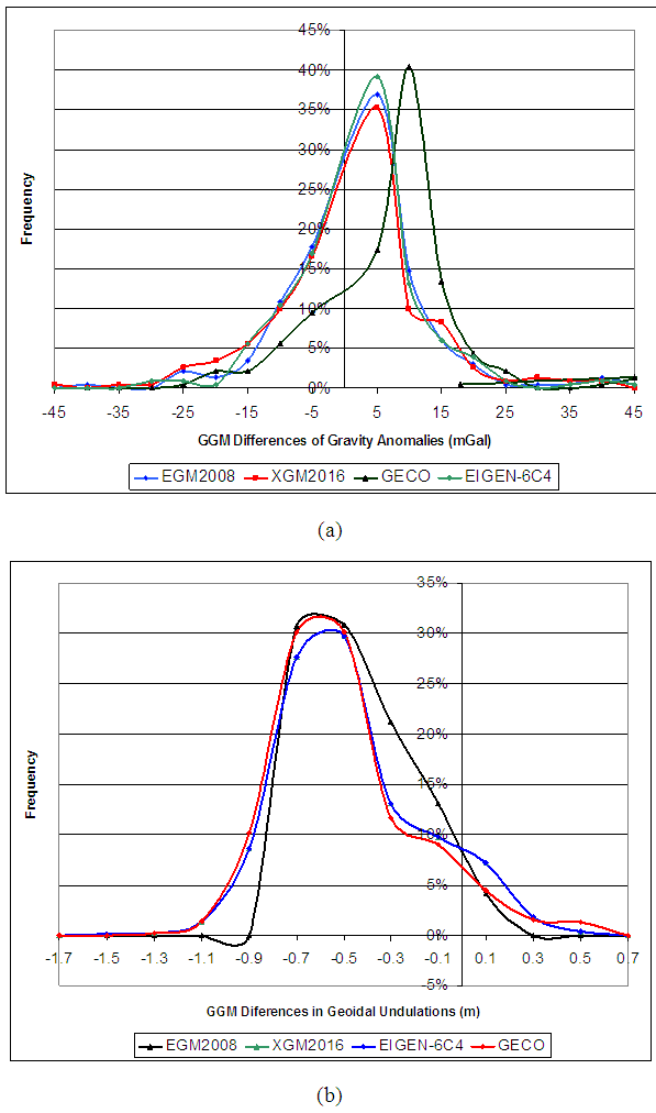 | Figure 4. Histograms of GGMs differences for: (a) Gravity anomalies, (b) Geoidal Undulations |
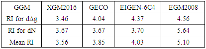
For each statistical measure, the values of all GGMs have been sorted in a descending order, and descending ranks, on a scale of 10. So, unique dimensionless RI values are obtained for the mean, range, and standard deviation. Then, the overall RI is computed as the weighted mean of the individual RI values. The utilized weights are 4 for the standard deviation, and 3 for both the mean and range. Therefore, it can be realized that the mean RI is unitless in nature that describes the overall accuracy performance of each GGM. That procedure has been repeated twice to obtain final RI for both gravity anomalies and geoidal heights of each investigated GGM. Accomplished results are tabulated in Table 2, which reveals that the EGM2008 is the optimum GGM for representing the gravitational field over Egypt with an average reliability index of 5.10, the EIGEN-6C4 comes in the second place, and the GECO comes third while the XGM2016 is the most worst GGM of the four investigated GGMs. Once more, it can be seen that the XGM2016 medium-resolution GGM performance is approximately similar to the GECO and EIGEN-6C4 high-resolution models. Table 2. Reliability Indices of GGM Differences (Unitless, on a scale of 10)
 |
| |
|
According to the obtained results represented, two important remarks should be highlighted here regarding the investigated GGMs and the available data. First notice is that the EGM2008 is the most suitable GGM, until now, to be applied in geoid modelling in Egypt. Second one: the XGM2016 is a promising model to represent the long wavelength of gravity, which indicates that the upcoming EGM2020 would be more precise in representing the Earth's gravitational field. Finally, the undulation errors of EGM2008 have been spatially modeled, using the IDW interpolation method, as a raster format (Fig. 5). Therefore, equation 4 will be modified into: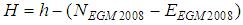 | (6) |
Where, NEGM2008 is the original geoid undulation of the EGM2008 model, and EEGM2008 represents its error estimate as interpolated from the correction surface at any GNSS observed station. 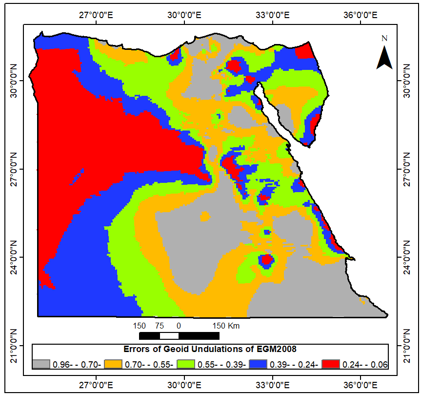 | Figure 5. EGM2008's Geoidal Undulations Correction Surface |
Along the current study area, it will be easy for GNSS users after observing the geodetic height of any point (h), to calculate its orthometric height (H) by estimating undulation value at this point using EGM2008 and also estimating undulation corresponding value from the EGM2008 correction surface, which should be open-access available. Consequently, within a specific level of precision applicable to small-scale mapping, such a practice significantly reduces the economic costs of field data collection stage as a result of dispensing levelling works anymore. Such a developed process is valuable for all GNSS-based surveying, mapping, data collection, and GIS activities in Egypt. Same procedures could be applied for heights transformation in any other country or regions.
4. Conclusions
GIS has been widely applied in numerous geodetic, surveying, and mapping activities. The creation of local geoid models over small areas and geoid interpolation have been, also, investigated using GIS. This paper presents a straightforward scheme to acquire, manipulate GGMs, and determine the most appropriate model and enhance its precision, entirely, within a GIS environment. Such a task, typically, was accomplished using specific mostly-academic geodetic software. GNSS and GIS users can considerably benefit from our proposed simple method in various geodetic activities. It is a matter of fact that an optimum GGM is required to convert the GNSS-based ellipsoidal heights into the MSL-based orthometric heights, or elevations, which is used in civil engineering different applications. The developed plan is mainly based on the ICGEM service, through downloading two grid files for each GGM, one for the gravity anomalies and the other for geoidal undulations. Using GIS, the precision and reliability of each GGM can be assessed over national geodetic databases, to determine the most suitable GGM to be used along any country or spatial region. The proposed method can be considered as a powerful GIS-based geodetic application for height conversion along Egypt region. The current study has utilized four GGMs in Egypt along with precise local geodetic datasets. Based on the introduced reliability measure and the available datasets, it has been concluded that the EGM2008 is still the best possible GGM, out of the investigated models, for representing the gravitational field over Egypt with an average reliability index of 5.10 on a scale of 10. A GIS-based correction surface has been; also, developed to increase its accuracy in GNSS height conversion for several geodetic, environmental, surveying, and mapping applications. The proposed approach could be; similarly, applied in other countries as well.
References
| [1] | Al-Krargy, E., Hosny, M. and Dawod, G. (2015) Investigating the precision of recent global geoid models and global digital elevation models for geoid modelling in Egypt, Regional Conference on Surveying and Development, Sharm El-Sheikh, Egypt, Oct. 3-6. |
| [2] | Odera, P. and Fukuda, Y. (2017) Evaluation of GOCEbased global gravity field models over Japan after the full mission using freeair gravity anomalies and geoid undulations, Earth, Planets and Space, DOI: 10.1186/s40623-017-0716-1. |
| [3] | Gomez, M., Perdomo, R., and Cogliano, D. (2017) Validation of recent geopotential models in Tierra Del Fuego, Acta Geophysics, No. 65: 931-943. |
| [4] | Alnaggar, D. (1986) Determination of the geoid in Egypt using heterogeneous geodetic data, PhD dissertation, Faculty of Engineering, Cairo University, Egypt. |
| [5] | Abd-Elmotaal, H. (2015) Egyptian geoid using best estimated response of the Earth's crust due to the topographic loads, Presented at the International Association of Geodesy Symposium, Switzerland, DOI: 10.1007/1345_2015_194. |
| [6] | Hassouna, R. and Asal, F. (2016) Using GIS-based digital raster analysis for improving harmonic models-derived geoidal heights, Applied Geomatics, 8:151–162. |
| [7] | Idrizi, B. (2013) Developing model for utilization of global earth gravimetrical models in Macedonian territory, Proceedings of the FIG Working Week 2013, Abuja, Nigeria, May 6–10. |
| [8] | Liu, S., Li, J., and Wang, S. (2011) The GPS height conversion method based on moving-surface fitting, Proceedings of the International Conference on Computer Science and Network Technology, December 24-26, Harbin, China, pp. 2113-2116. |
| [9] | Das, R., Samanta, S., Jana, S. and Rosa, R. (2017) Polynomial interpolation methods in development of local geoid model, The Egyptian Journal of Remote Sensing and Space Sciences, DOI: 10.1016/j.ejrs.2017.03.002. |
| [10] | ICGEM (The International Center for Global Earth Model) (2018), http://icgem.gfz-potsdam.de/tom_longtime, Accessed 20 February 2018. |
| [11] | Hofmann-Wellenhof, B. and Moritz, H. (2005) Physical geodesy, SpringerWien, New York. |
| [12] | Pail, R. Fecher, T., Barnes, D., Factor, J., Holmes, S., Gruber, T., and Zingerle, P. (2017) Short note: the experimental geopotential model XGM2016, Journal of Geodesy, DOI: 10.1007/s00190-017-1070-6. |
| [13] | Gilardoni, M., Reguzzoni, M., Sampietro, D. (2016) GECO: a global gravity model by locally combining GOCE data and EGM2008; Studia Geophysica et Geodaetica, Vol 60: 228-247. |
| [14] | Förste, C., Bruinsma, S., Abrikosov, O., Lemoine, J., Marty, J., Charles, F., Frank, B., Barthelmes, F., Biancale, R. (2014) EIGEN-6C4: The latest combined global gravity field model including GOCE data up to degree and order 2190 of GFZ Potsdam and GRGS Toulouse, Presented in the 5th GOCE user workshop, Paris, France, Nov. 25-28, DOI: 10.5880/ICGEM.2015.1. |
| [15] | Pavlis, N.K., Holmes, S.A., Kenyon, S.C., Factor, J.K. (2008) An Earth Gravitational Model to Degree 2160: EGM2008, Presented in the EGU general assembly, Vienna, Austria, April 13-18. |
| [16] | Dawod, G. and Al-Ghamdi. K. (2017) Reliability of recent global digital elevation models for geomatics applications in Egypt and Saudi Arabia, Journal of Geographic Information System, V. 9(6): 685-698. |

 Abstract
 Reference
 Full-Text PDF
 Full-text HTML