Ali El Sagheer1, Maher Amin2, Mervat Refaat3, Omayma Obada4
1Professor of Surveying and Geodesy, Head of Surveying Engineering Department, Banha University, Egypt
2Assoc. Prof. of Surveying Engineering Department, Banha University, Egypt
3Lecturer. of Surveying Engineering Department, Banha University, Egypt
4PhD. Student of Surveying Engineering Department, Banha University, Egypt
Correspondence to: Omayma Obada, PhD. Student of Surveying Engineering Department, Banha University, Egypt.
| Email: |  |
Copyright © 2018 Scientific & Academic Publishing. All Rights Reserved.
This work is licensed under the Creative Commons Attribution International License (CC BY).
http://creativecommons.org/licenses/by/4.0/

Abstract
The uses of the River Nile can be improved in transportation, tourism and other important fields by using Geographical Information System (GIS) and Remote Sensing techniques as creating River Nile basemap for monitoring River Nile resources. In order to develop an updated base map for River Nile in Egypt, it was necessary to address, review, assesses and evaluates the available different free sources satellite images. In this paper, four study areas over Egypt were chosen and definite points were observed for those areas using GPS techniques. The same specified points were determined on the available free satellite images. Assessment for free sources satellite images, in terms of horizontal accuracy, and depending on the available images resolution, has been evaluated. The obtained results of Root Mean Square Error (RMSEr) for horizontal coordinate differences in small areas vary from 1.57 m to 5.06 m, and large area varies from 8.52 m to 9.15 m. Image registration techniques were applied using two dimensional transformations process in the previous four study areas between the two free sources satellite images (Image-to-Image registration) and between satellite image and GPS points (Image-to-Ground registration) to get the register image points with suitable accuracy comparable with GPS accuracy and images resolution. The transformation parameters (Scale (s), Rotation (θ) and Translations (ΔX, ΔY)) are calculated for the areas under consideration. The Root Mean Square Error (RMSEr) obtained from the transformation process in small areas varies from 1.94 m to 2.86 m and in large area varies from 7.428 m to 8.586 m. Then these calculated transformation parameters used to transform other points onto the required system. This approach can be used in different areas which have lack of GPS observed points to calculate semi-ground points from transformed measured free imagery points with suitable accuracy compared with the accuracy of GPS and images resolution. Finally, using free sources satellite images with Geographic Information System Application to building an updated basemap for River Nile in Egypt.
Keywords:
Satellite Imagery, Google Earth Imagery, ARCGIS on Line, Global Positional System (GPS), Horizontal Positional Accuracy, Image Registration, Coordinate Transformation, Basemap and Geographic Information System
Cite this paper: Ali El Sagheer, Maher Amin, Mervat Refaat, Omayma Obada, Developing Updated Basemap for River Nile in Egypt Using Free Sources Satellite Images, American Journal of Geographic Information System, Vol. 7 No. 1, 2018, pp. 32-39. doi: 10.5923/j.ajgis.20180701.03.
1. Introduction
River Nile is one of the longest rivers in the world, its drainage basin covers eleven countries and it represents more than 95% of the total water resources in Egypt. In Egypt, the River Nile creates a fertile green valley across the desert. It was by the banks of the river that one of the oldest civilizations in the world began. Most Egyptians lived near the Nile as it provided water, food, transportation and excellent soil for growing food. [1]. Below the Aswan High Dam, at the northern limit of Lake Nasser, the Nile resumes its historic course. North of Cairo, the Nile splits into two branches (or distributaries) that feed the Mediterranean Delta: the Rosetta (Rashid on the west) and the Damietta (Dumyat on the east) forming the Nile Delta, as shown in Figure (1). [3] Egypt and other countries that share the Nile River Basin show interest in studying how to manage and develop water resources in recent years, and that interest was reflected through studies and research for a number of involved international bodies and institutions.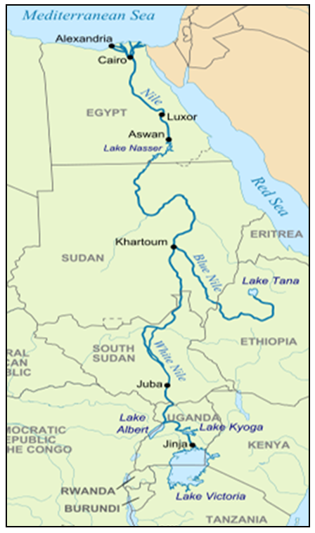 | Figure 1. The River Nile Basin in Africa [20] |
This point has entertained thinking about doing this research, based on the available free sources satellite data using GIS and Remote Sensing as image provided from google earth application. Google Earth (GE) is the most popular virtual globe that offers free access to high resolution imagery for most of the planet. Since the launch of the program in 2005 by Google, Unfortunately, given the popularity of GE, users tend to assume that it is an accurate source of information and also tend not to question its credibility [6]. Moreover, Benker, Langford and Pavlis [2] note that Google representatives state that the coordinates provided by Google are approximations only and that, therefore, Google makes no claims as to the accuracy of their geographic information products [8]. However, in 2008, Google initiated a project called “Ground Truth” in order to increase the accuracy of their geographic products by means of acquiring data from authoritative sources [8] such as INEGI (the Mexican National Institute for Geography and Statistics) and NGA (the USA National Geospatial-Intelligence Agency). As a result of its popularity, GE is commonly used by the scientific community in their projects. GE has been used, for example, to collect ground control points (GCPs) for orthorectification of satellite imagery [16], to estimate urban vegetation cover [17].In most of the scientific applications listed above, the authors of the papers have exercised some caution with regards to the accuracy of GE. Therefore, in order to understand and reduce the uncertainties associated with the use of GE in different applications, accuracy assessments of GE’s imagery are required [13, 17]. Consequently, a series of accuracy assessments of GE’s imagery have been undertaken by different researchers. Potere (2008) evaluated the horizontal positional accuracy of GE’s imagery using control points extracted from the Landsat GeoCover dataset and estimated a global horizontal root mean squared error (RMSEr) of 39.7 m. other study, [2]used high precision field measurements (<1 m) to assess the accuracy of Google Earth’s imagery in the Big Bend region of Texas, USA and found that Google Earth’s imagery has a horizontal mean error of 6.95 m and RMSEr of 2.64m and another regional study, [16] estimated Google Earth’s horizontal accuracy in 6.1m RMSEr, with a mean horizontal error of 4.8 m, using 13 check points (CPs) collected from 1:2,000-scale maps and distributed over a study area of approximately 215 km in width located in southern Iran.Therefore, in this paper we attempt to contribute to the understanding of the horizontal positional accuracy of GE’s imagery and another source of free accesses satellite images (ArcGIS on line wv2) by means of a study case undertaken over four study areas in Egypt, using accurate field GPS points. In the following sections we calculate 2D transformation parameters between these free access sources and GPS ground points and finally develop a database from these free access sources.
2. Available Data Used
2.1. Google Earth Satellite Free Source Images
Google Earth (Earth browsers) is a geobrowser, virtual globes or geographic browser that accesses satellite and aerial imagery, ocean bathymetry, and others geographic data over the internet to represent the Earth as a free three-dimensional globe [21]. The satellite and aerial images in Google Earth are taken by cameras on satellites and aircrafts, which collect each image at a specific date and time. Those images can be used in Google Earth as a single image with the specific collection date, and common use the images are combined into a mosaic of images taken over multiple days or months. These images are displayed as one seamless image and the date may change from image to image as you move your cursor around the mosaic. There is limited information about the image collection and the date displayed reflects the start of a date range when the image was most likely collected. The collection date information is lost or inaccurate due to human error or other issues. [22]. Google Earth's Imagery resolution ranges from 15 m to 15 cm [23]. For its reference system, KML uses 3D geographic coordinates are as defined by the World Geodetic System of 1984 (WGS84). The vertical component (altitude) is measured from the WGS84 and based on EGM96 Geoid vertical datum [12].
2.2. ArcGIS on Line Satellite Images
ArcMap is the main component of Esri's ArcGIS suite of geospatial processing programs, and is used primarily to view, edit, create, and analyze geospatial data. ArcMap allows the user to explore data within a data set, symbolize features accordingly, and create maps. [24]. A basemap in ArcGIS online or ArcMap application provides a background of geographical context for the content you want to display in a map. When you create a new map, you can choose which basemap you want to use. [25]. One of the available high resolution imagery in ArcMap is World View-2. The World View-2 imaging payload is the second such system engineered and manufactured by ITT Space Systems Division for Digital Globe. World View-2 operates at an altitude of 770 km, and the advanced on-board imaging system can capture pan-sharpened, multispectral images (with better than 46 cm resolution). These images supply unprecedented detail and geospatial accuracy, further expanding the applications for satellite imagery in both commercial and government markets. Added spectral diversity provides the ability to perform precise change detection and mapping. [26]
2.3. Ground GPS Control Points
To deal with different free sources satellite images in Egypt, GPS control points were observed in the chosen four study areas using different GPS receivers and applying certain GPS observation techniques as Static and Real Time Kinematic (RTK) techniques. In which the base station was located in a fixed control point and the rover was used to observe the other required points. These points were observed on the same datum for different free sources satellite images WGS-84.
3. Study Areas under Investigation
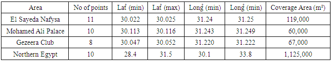
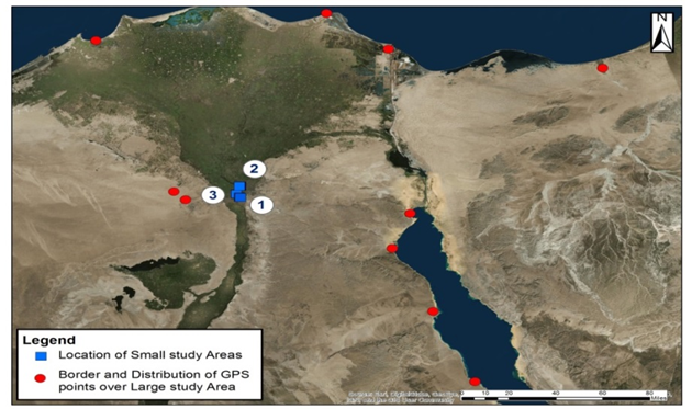
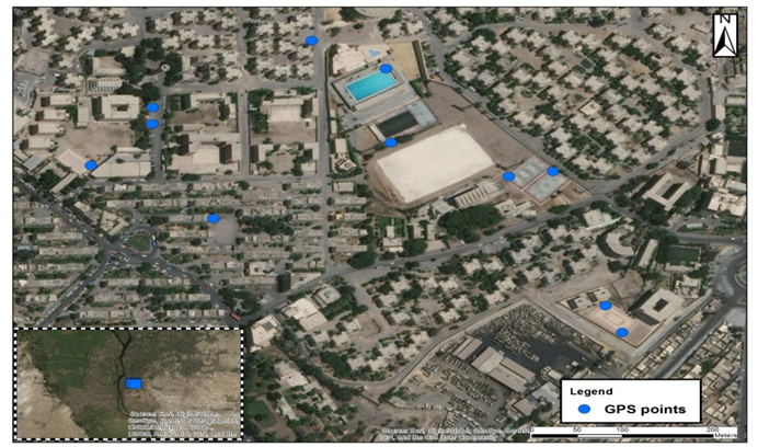
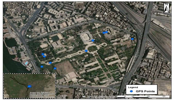
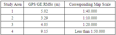
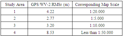
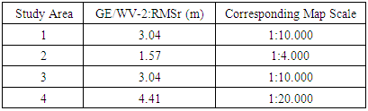
In order to assesses and evaluates the available different free sources satellite images, four study areas over Egypt were chosen, as shown in Figure (2). The description and the available GPS points for these study areas are given in Table (1). The investigated areas were divided into two main categories according to the coverage area i.e., small or large areas. Three study areas (small areas) are located at El Sayeda Nafysa, study area (1), Figure (3), Mohamed Ali Palace, study area (2), Figure (4), El Gezeera Club, study area (3), Figure (5). The fourth study area (large area) is located at Northern part of Egypt, study area (4), as shown in Figure (2), GPS points mostly distributed over northern part of Egypt.Table 1. Description of the Study Areas and the Available GPS Points over Egypt
 |
| |
|
 | Figure 2. Location of Four Study Areas over Egypt. (Map scale 1:700,000) |
 | Figure 3. Distribution of GPS Points over El Sayeda Nafysa, (Map scale 1:3000) |
 | Figure 4. Distribution of GPS Points over Mohamed Ali Palace. (Map scale 1:4000) |
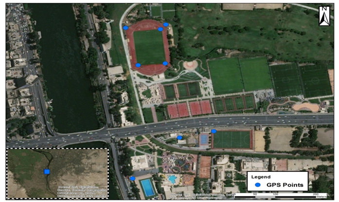 | Figure 5. Distribution of GPS Points over El Gezeera Club. (Map scale 1:3000) |
4. Methodology of Investigation for Creation Updated Base Map for the River Nile in Egypt
The following designed flow chart of working steps which will be applied consequently in this research, as shown in Figure (6).  | Figure 6. Flow Chart of the Work Steps for Creating Updated Base Map for the River Nile in Egypt |
Assessment for the available free sources satellite images horizontal accuracy over Egypt can be done, as the first step (A) by comparing measured points in Google Earth images and the same measured points in ArcGIS online World View–2 images, with GPS observed coordinates for the same points in the four study areas over Egypt. [11] The second step (B) is dealing with two image registration techniques, Image-to-Image registration (B1) refers to transforming one image coordinate system into another image coordinating system and Image-to-Ground registration (B2) refers to transforming one image coordinate system into ground observed coordinating system as GPS coordinates. Several approaches have been proposed for image registration [1] and [3]. This can be done in the same four study areas over Egypt to register the used free sources satellite images, and then get the other imagery points with definite accuracy comparable with GPS accuracy. 2D-similarity functions have been used as the transformation function and the optimum sequences for the parameter estimation based on line segment orientation and various regions within the image have been derived. Using real data sets, the results proved the reliability [15]. Image registration can be produced in two followed steps. The first one is calculating 2D-coordinate transformations parameters using the observed common points to get more accurate solution. The second step (B4), the reverse process, by transforming the available coordinates of free sources satellite images into geodetic global positional system and gets the point's residuals by using the calculated 2D-coordinate transformations parameters from the previous step. Finally, using free sources satellite images with Geographic Information System Application to build up an updated basemap for River Nile in Egypt (C). This basemap depicting background reference information is used for locational reference [27]. The developed updated basemap through this work represented a valuable tool for evaluating and analysing the River Nile track which supporting the decision making process in different ways for example on river navigation.
5. Assessment of Free Sources Satellite Images and the Obtained Results
The available different free sources satellite images horizontal positional accuracy for the four study areas over Egypt was assessed in terms of (x, y) and horizontal displacement RMSEx, RMSEy and RMSEr, respectively computed. The following Equations [FGDC (1998)] can be used: | (1) |
 | (2) |
 | (3) |
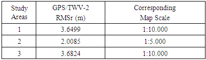
Where:X (image), Y (image) are the coordinates of the (ith) point in the evaluated dataset (different free sources satellite images). X (GPS), Y (GPS) are the coordinates of the (ith) point in the independent reference dataset of GPS observed points. (n) is the number of available points, (i) is an integer that ranges from 1 to n. The Root Mean Square Error (RMSEr) calculated for free sources satellite images in term of horizontal accuracy for four study areas, are given in Table (2a), (2b), (2c).Table 2a. Global Positioning System & Google Earth
 |
| |
|
Table 2b. Global Positioning System & World View-2
 |
| |
|
Table 2c. Google Earth & World View-2
 |
| |
|
The results showed that this assessment has acceptable performance for different purposes. Root Mean Square Error (RMSEr) for horizontal coordinates in small areas varies from 1.57 m to 5.06 m and in large area varies from 8.52 m to 9.15 m. The variation of Root Mean Square Error (RMSEr) values for horizontal coordinates depending on the following reasons; change in imagery resolution, change in imagery time, change in area size and locations. According to the above assessments which achieved different results with its corresponding map scales, so these data can be used in multi uses, for example it can use in image registration. Consequently, it can use to construct an updated base map along the River Nile in Egypt by using on screen digitizing techniques from different free sources satellite images, as the required product from this research.
6. Image Registration for Different Free Sources Satellite Images and the Obtained Results
Image registration techniques, Image-to-Ground registration (B2) and Image-to-Image registration (B1), for different free sources satellite images can be done by applying the 2D-transformation technique. The transformation process consists of two stages; the first stage is the determination of the transformation parameters; Scale (s), Rotation (θ) and Translations (ΔX, ΔY) for the areas under consideration. The second stage (B4) is to use the produced transformation parameters calculated from the previous stage to transform the other points onto the required system with suitable accuracy compared with the accuracy of GPS and image resolution i.e. to achieve a complete image registration process. [28]
6.1. Determination of 2D-Transformation Parameters
The full 2D-transformation technique, with two translation parameters (ΔX, ΔY), one rotation (θ) and a scale parameter (s) = K = (1+k), known as Helmert transformation, may be expressed as [10]: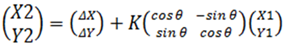 | (4) |
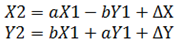 | (5) |
Where: and Θ=a tan (a/b) [29].
6.2. The Obtained Results for the 2D-Transformation Parameters
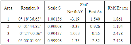
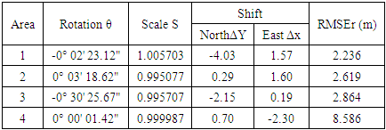
The following Tables (3) and (4) show the best and final results after many trials for the full 2D-transformation technique, with two translation parameters (ΔX, ΔY), one rotation (θ) and a scale parameter (s), w.r.t (RMSEr) for residuals at the target control points over the four study areas in Egypt.Table 3. 2D Transformation Parameters between GPS and World View-2 Coordinates
 |
| |
|
Table 4. 2D Transformation Parameters between GPS and Google Earth Coordinates
 |
| |
|
6.3. Assessment of the Obtained 2D-Transformation Parameters
Using the obtained 2D-transformation parameters to transform the same specified points were determined on the available free satellite images, Google Earth and World View–2 measured coordinates, this step applied to get at any time and at any different locations transformed measured free imagery points with suitable accuracy compared with the accuracy of GPS and images resolution. Residuals at the coordinates under investigation are given in Tables (5) and (6).Table 5. Residuals between GPS and Transformed World View-2 Coordinates
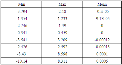 |
| |
|
Table 6. Residuals between GPS and Transformed Google Earth Coordinates
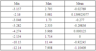 |
| |
|
6.4. Assessment Impact of Large Area's Obtained 2D-Transformation Parameters on Small Areas
Assessment Impact of large area's obtained 2D-transformation parameters means to use large area obtained 2D-transformation parameters for small areas' images registration. The objective of this step, and after determination of 2D-transformation parameters between (GPS/Google coordinates) and/or (GPS/WV-2 coordinates) for the large area with definite accuracy so converting any point on the different free sources satellite images into the ground coordinates frame. Due to factors of high cost monitoring, lack of availability of observed GPS points around the River Nile which can be solved using 2D-transformation between (GPS/Google coordinates) and/or (GPS/WV-2 coordinates) for the large area, study area (4), to transform the coordinates for small areas, study areas (1), (2) and (3) respectively. Differences between (GPS and Transformed Google (TGE)), (GPS and Transformed World View-2 (TWV-2)) coordinates in study areas (1), (2) and (3) were computed and the Root Mean Square Error (RMSEr) was calculated for horizontal accuracy as shown in Table (7a) (7b).Table 7a. The Root Mean Square Error (RMSEr) for Horizontal Accuracy Using Large Area 2D-Transformation Parameters (GPS and Google)
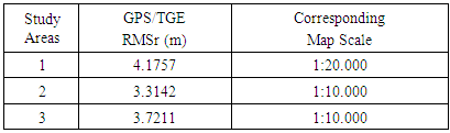 |
| |
|
Table 7b. The Root Mean Square Error (RMSEr) for Horizontal Accuracy Using Large Area 2D-Transformation Parameters (GPS and World View-2)
 |
| |
|
As shown in table 7a and 7b the calculated RMSE between GPS points and the transformed Google Earth and WV2 points using the calculated 2D transformation parameters calculated in section 6.1 and 6.2 in large area and its corresponding map scale can be used in.
7. Developing Updated Base Map for the River Nile in Egypt Using Free Sources Satellite Images
Basemap is a collection of GIS data and/or registered imagery that form the background setting for a map [30]. The function of the basemap is to provide background detail necessary to orient the location of the map [31]. The main aim of this research was to develop basemap for River Nile in Egypt using available free sources satellite images. Using free sources satellite images with Geographic Information System application to build up an updated basemap for River Nile in Egypt can be achieved. The working steps which applied consequently here are:1. Using on screen digitizing in free sources satellite images to digitize main streams and sub-streams within the River Nile catchment area.2. Converting digitized streams KMZ file to Database file using ArcToolbox Application.3. Applying Data Quality Control on streams layer. Data Quality Control (DQC) is the process of controlling the usage of data with known quality measurement. It can be applied by either manual or automated process. Automated procedures depend on spatial relationship matrix called Topology. Once you have discovered the topology errors, you can handle this error on the map using fix topology tools. 4. In ArcCatalog application a new topology layer was created in the same dataset with streams layer in the above mentioned database.5. After applying full Data Quality Control (DQC), developing updated basemap for River Nile in Egypt using free sources satellite images with streams layer is produced, as shown in Figure (7).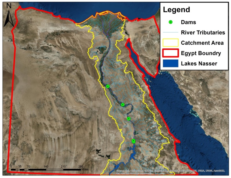 | Figure 7. Updated Basemap for River Nile Basin in Egypt. (Map scale 1:2,000,000) |
8. Conclusions
Availability of data that make users in different disciplines use free sources satellites images in positional data extraction encourage specialists to carry out researches in order to test and evaluate positional extracted data. In this context, it was necessary at the beginning to address, review, assesses and evaluates these sources of free and open accesses satellite images, including Google Earth Application and Esri ArcGIS online data. Assessment for free sources satellite images, in terms of horizontal accuracy, and depending on the available images resolution, has been done. The obtained results of Root Mean Square Error (RMSEr) for horizontal coordinate differences in small areas vary from 1.57 m to 5.06 m, and large area varies from 8.52 m to 9.15 m. The results showed that free sources satellites images represents a powerful and attractive source of positional data that can be used for investigation and preliminary studies with suitable accuracy and low cost.Image registration techniques for different free sources satellite images are a prerequisite step for many important applications in different disciplines. This done in the same four study areas in Egypt, to register the used free sources satellite images, and then get the other points with suitable accuracy comparable with GPS accuracy and images resolutions. Several experiments have been conducted using image registration techniques, for register the different free sources satellite images. The obtained result of the transformation process i.e. Root Mean Square Error (RMSEr) in small areas varies from 1.94 m to 2.86 m and in large area varies from 7.428 m to 8.586 m. The obvious differences are as a result of many factors such as the difference in the images times, the images resolutions, defining the measured points and the natural of area under consideration. Finally, using free sources satellite images with the help of Geographic Information System Application to build up an updated basemap for the River Nile in Egypt to be used in different proposes lately. The developed updated basemap through this work represented a valuable tool for evaluating and analyzing the River Nile pathway which supporting the decision making process in different ways for example on river navigation.In future studies, all the pervious steps can be a doubted in different locations within the River Nile Basin outside Egypt if GPS points were available. User should take into consideration the difference in images resolution case of using different images from different sensors. One should consider the selection of points to be clear and sharp defined to be easy to identify them in the images. The number of points used in calculating 2D-coordinate transformations relating with areas different size, locations and images different times and resolutions. Any area under study should be available in which at least three points if either worked with 2D-coordinate transformations parameters as in case of developing countries. Consequently, in developing countries in case of shortage of ground control points or GPS points using low cost receivers to observe GPS control points will be match with free sources satellite images resolutions and give consistent results.
References
| [1] | Barbara Zitová, 2003, "Image registration methods". A survey Image and Vision Computing, Volume 21, Issue 11, Pages 977-1000. |
| [2] | BENKER, S.C; LANGFORD, R.P.; PAVLIS, T.L. Positional accuracy of the Google Earth terrain model derived from stratigraphic unconformities in the Big Bend region, Texas, USA. Geocarto International, 26(4), 291-301, 2011. |
| [3] | BROWN, L.G., 1992, "A survey of image registration techniques". ACM Computing Surveys, 24, pp. 325–376. |
| [4] | DUHL, T.R.; GUENTHER, A.; HELMIG, D. Estimating urban vegetation cover fraction using Google Earth® images. Journal of Land Use Science, 7(3), 311- 329, 2012. |
| [5] | Federal Geographic Data Committee, 1998, FGDC-STD-001. |
| [6] | FLANAGIN, A.J; METZGER, M.J. The credibility of volunteered geographic information. GeoJournal, 72, 137-148, 2008. |
| [7] | FRYER, J.G., 1993, "Affine or conformal? Fiducials or not!", Australian Journal of Geodesy, Photogrammetry and Surveying, 58, pp. 23–35. |
| [8] | GOOGLE. Source for elevation data. Google Product Forums. 2008. https://groups.google.com/forum/?fromgroups=#!topic/earthdata/KsRTsXULRNk. Accessed: 20 March 2013. |
| [9] | HANLEY, H.B. and FRASER, C.S., 2001, "Geopositioning accuracy of IKONOS imagery: indications from two dimensional transformations". Photogrammetric Record, 17, pp. 317–328. |
| [10] | Hofmann-Wellenhof, B., Lichtenegger, H., Collins, J., 2001, "Global Positioning System Theory and Practice." ISBN 978-3-7091-6199-9. |
| [11] | Mohammad Ali Goudarzi and René Jr. Landry, 2017, "Assessing horizontal positional accuracy of Google Earth imagery in the city of Montreal Canada." Geodesy and Cartography Journal, Published online: 25 Jun 2017 Volume 43, 2017 - Issue 2. |
| [12] | Nagi Zomrawi Mohammed, Ahmed Ghazi and Hussam Eldin Mustafa, 2013, "Positional Accuracy Testing of Google Earth. International Journal of Multidisciplinary Sciences and Engineering, VOL. 4, NO. 6, JULY 2013 ISSN: 2045-7057. |
| [13] | POTERE, D. Horizontal positional accuracy of Google Earth’s high-resolution imagery archive. Sensors, 8, 7973-7981, 2008. |
| [14] | SHAKER, A., SHI, W.Z. and BARAKAT, H., 2005, "Assessment of the rectification accuracy of Ikonos imagery based on two-dimensional models". International Journal of Remote Sensing, 26, pp. 719–731. |
| [15] | WENZHONG SHI and AHMED SHAKER, 2006, "The Line-Based Transformation Model (LBTM) for image-to-image registration of high-resolution satellite image data" International Journal of Remote Sensing Vol. 27, No. 14, 20 July 2006, 3001–3012. |
| [16] | YOUSEFZADEH, M.; MOJARADI, B. Combined rigorous-generic direct orthorectification procedure for IRS-p6 sensors. ISPRS Journal of Photogrammetry and Remote Sensing, 74, 122-132, 2012. |
| [17] | YU, L.; GONG, P. Google Earth as a virtual globe tool for Earth science. |
| [18] | http://primaryhomeworkhelp.co.uk/egypt/nile.htm#1. |
| [19] | https://en.wikipedia.org/wiki/Nile#In_Egypt. |
| [20] | https://www.google.com.eg/search?q=river+nile+in+egypt. |
| [21] | http://serc.carleton.edu/sp/library/google_earth/what.html. |
| [22] | https://support.google.com/earth/answer/6327779?hl=en. |
| [23] | https://en.wikipedia.org/wiki/Google_Earth. |
| [24] | https://en.wikipedia.org/wiki/ArcMap. |
| [25] | http://doc.arcgis.com/en/arcgis-online/create-maps/choose-Basemap.htm. |
| [26] | http://www.satimagingcorp.com/satellite-sensors/worldview-2/. |
| [27] | https://support.esri.com/en/other-resources/gis-dictionary/term/basemap. |
| [28] | https://en.wikipedia.org/wiki/Image_registration. |
| [29] | https://www.fig.net/resources/proceedings/fig_proceedings/athens/papers/ts07/ts07_2mitsakaki.pdf. |
| [30] | https://www.gislounge.com/basemaps-defined. |
| [31] | https://doc.arcgis.com/en/arcgis-online/create-maps/choose-basemap.htm. |

 Abstract
 Reference
 Full-Text PDF
 Full-text HTML