American Journal of Geographic Information System

p-ISSN: 2163-1131    e-ISSN: 2163-114X

2017;  6(5): 178-186

doi:10.5923/j.ajgis.20170605.02


Land Administration Domain Model in Review towards the Adoption as a Reference Model for Land Administration System in Nigeria

Babalola Sunday Oyetayo1, 2, Abdul Rahman A.1, Choon L. T.1, Idowu T. O.2, Abidoye A. I.3

1Faculty of Geo-information and Real Estate, Universiti Teknologi Malaysia, Malaysia

2Department of Surveying and Geoinformatics, Federal University of Technology Akure, Nigeria

3Faculty of Evronmental Design and Management, Obafemi Awolowo University, Ile Ife, Nigeria

Correspondence to: Babalola Sunday Oyetayo, Faculty of Geo-information and Real Estate, Universiti Teknologi Malaysia, Malaysia.

Email:

Copyright © 2017 Scientific & Academic Publishing. All Rights Reserved.

This work is licensed under the Creative Commons Attribution International License (CC BY).
http://creativecommons.org/licenses/by/4.0/

Abstract

LADM covers the relevant information identified with the parts of land administration together with those over water and components beneath the earth surface. The standard provides a unique conceptual model together with three packages and sub-package. It is characterized terminologies for land administration system that allows a common portrayal of various informal standard or formal tenures. The standard additionally offers the establishment for regional and national profiles and permits the mix of land management information from different sources in an articulated manner. Given this, this study began with the depiction of land and land administration in Nigeria. The dialog of the pre-Colonial, Colonial and post-Colonial period and the hierarchical structure is important in order to exhibit an understanding foundation of the improvement required for LADM adoption in Nigeria. LADM and the packages were discussed and appraisal of the diverse elements of each class and packages was made with Nigerian land administration. In the comparison made, it was discovered that the model (LADM) could be effectively embraced into Nigerian land administration. As per this study, the terminologies used are not absolutely the same as a rule, but rather new one might be presented and fittingly clear in a version. The conclusion is that LADM can be adopted by mapping a portion of the ideas of LADM standards into Nigerian land administration system.

Keywords: Land Registration, LADM, Land Administration, Land Reform, Land Use Act, Packages

Cite this paper: Babalola Sunday Oyetayo, Abdul Rahman A., Choon L. T., Idowu T. O., Abidoye A. I., Land Administration Domain Model in Review towards the Adoption as a Reference Model for Land Administration System in Nigeria, American Journal of Geographic Information System, Vol. 6 No. 5, 2017, pp. 178-186. doi: 10.5923/j.ajgis.20170605.02.

1. Introduction

Land administration framework began in Nigeria before the colonial time. Generally, the pre-colonial land administration and the cadastral framework was portrayed by the allocation and settling of the might of fighting, ruler ship in which King and warlord cut out regions for their blossoms [1]. The family and their supporters possessed the territory cut out for them; the land was used for brushing and cultivating purposes to stamp the start of land administration prior before the colonial time. In this manner, lands are claimed by the groups, towns, and families. The individual is having usufructuary rights because they are individuals from the community, which is stretched out to their family. The boundary of the land is dictated by the characteristic components, for example, a tree for every community or family. The circumstance in the northern part of Nigeria was unmistakable from the southern part. The Fulanis are the catle rarer. They take their cattle over an immense land and make their settlement without portraying the boundary and the limit of the territory. The Emirs have the outright title to land after the war as settled by the emirates.
Nigeria is situated between 4°-14°N and longitude 2°-15°E [22] in West Africa with 36 States and the Federal capital region, Abuja. There are more than 400 unique dialects, 774 nearby Government and 250 ethnic talking gathering. The whole nation was divided into six Geopolitical Zone used for arranging and political representative. The land administration practise in every area and State of the same geopolitical Zone is firmly related because of their geo-political combination and connection [3]. The land administration framework transformed and experienced rebirth of birth and resurrection throughout the years in many developed, undeveloped and developing nation. Nigeria, a developing nation additionally advances in her land administration system. It was intended to help dealings in the privileges of individuals, formal and informal individual, urban and provincial society in association with the land. The information associated with the land matter (accessible control and the control association with the end goal of the new overview) was additionally made accessible to everybody interfacing with the land exchange whenever. Appropriate to this information gives the security to the matter of lands and offers the chance to distinguish the deals [30]. The (FIG) International Federation of Surveyors representing the welfares of Surveyors around the world, in 1994 approved the FIG Commission 7 to work out the vision for future cadastre framework (Cadastre 2014, FIG1998) [13].
The improvement practice of cadastre 2014 begins the start of (CCDM) Core Cadastral Domain model and (LADM) Land Administration Domain Model [8], [34]. LADM was distributed on December first, 2012 by International Standard Organization ISO19152:2012 [9] and [32]. LADM was intended to help the improvement of the application programming and the nature of data in data management framework. It is an extendable, viable and productive International standard which had some expertise in different nations to build up their packages of LADM.
This study began with a presentation of the land administration framework in the study range and its portrayal. Section 2, talked about the outline and improvement of LADM with early work done by the pioneers and the specialists. Section 3 talked about the land administration framework, Land Use Act of 1978, the impact of the colonial time, the insufficiencies of the Land Use Act and the requirement for the change. Section 4, examined LADM packages to sum things up, and its pertinence in the land administration framework, in section 5, the significance, connections, and fluctuations amongst LADM and Land Administration system of Nigeria was distinguished. Section 6 of this investigation is on the forthcoming works and conclusion.

2. Historical Evolution of LADM (ISO 19152:2012)

The adventure to LADM began with the Ph.D. thesis of Christiaan Lemmen with the essential goal to create LADM [17]. The possibility of LADM came up in 2002 at Washington DC amid FIG Congress to plan LADM. From that point forward, there are various examinations relating straightforwardly or in a indirect way to LADM. [31], did an investigation on the approval of LADM in Indonesia by showing and contrasting it and comparable recreation demonstrate and suggested the approval in another nation to make usage of LADM International worthy. He inferred that the reception of LADM into Indonesia land administration was in fact conceivable by changing the current data show into the LADM. Notwithstanding, Annex An of the Final Draft International Standard (FDIS) determines how to test a specific application blueprint whether is adjusted to LADM in packages and level. Testing a specific data set suggested that the data set substance as against the comparing data set fit in with LADM application diagram [9]. As per [17], the model must be conceivable to be used as the essential reference show and be locally and International accepted in the land administration framework.
[28], proposed an approach when contrasting cadastral administration framework in view of the ISO 19152 particularly between Quebec (Canada) and Alsace-Moselle (France) apartment suite units. The study talked about the points of interest, the impediments and offered guidance to deliver a similar investigation for other cadastral frameworks. The standard arrangement of idea and terms as proposed by LADM enables the writers to measure the similitudes the distinctions, and possibility moved towards the making of coordinating record between the two frameworks. In any case, the initiator reasoned that time is expected to comprehend the documentation as some LADM classes and packages are as yet hard to coordinate the two frameworks.
While breaking down the potential outcomes of connecting the land registers and other authority registration in the Republic of Croatia in light of LADM, [21] gave recommendations on how the adequacy of the registers can be expanded by connecting with LADM in the wake of directing utilizing diagram coordinating. The authors recommended the use of this study to make a procedure for enhancing the adequacy of the general procedure of the registers to enhance the monetary advance of the Republic of Croatia. [16], proposed the change of the Korean LADM nation profile to construct a 3D cadastral model. The authors use a cadastral resurvey shape, of 3D physical property representation and 3D rights. Having created Korean LADM nation profile since 2012 inferred that, the new 3D form the nation profile would be for the cutting edge in Korea. In a guide to embrace the LADM in cadastral information frameworks by [14], the investigation created an all-encompassing perspective and an essential thought for the execution of LADM. The study uncovered the institutional plan, authoritative inspiration, administration and limit building.
Thus, LADM standard has been considered by various nations to receive it to their local needs in land administration system [33] and [27]. LADM was connected in Europe for Infrastructure Spatial Information (ISI) to demonstrate the similarity with INSPIRE. Moreover, examinations were done to the joining of LADM with Land Parcel Identification System (LPIS) [26]. The United Nations Committee of Experts on Global Geospatial Information Management (UN-GGIM), the Government of Ethiopia and the United Nations Economic Commission for Africa (UNECA), met the fourth Forum on United Nations Global Geospatial Information Management at UNECA's in April 2016. The subject of the gathering was ''Good Land Governance for the 2030''. The Forum take steps to create and settle on an arrangement of key geospatial information components for land administration as a subset of the UN-GGIM basic data topics lined up with the SDG worldwide marker structure, considering ISO 19152:2012. Land Administration Domain Model and advance in multi-dimensional cadastre and city models [11]. The major data structures that were used by the SOLA programming are additionally in light of the LADM which was formally propelled at the 25th FIG Congress of twentieth June 2014 in Kuala Lumpur, Malaysia [10]. Some prominent chips away at LADM by the academician and analyst from 2012 and 2015 incorporates; [2, 4-6, 12, 14, 15, 23, 25, 29, 33, 36, 37, 39] and others.

3. The Nigerian Land Administration System

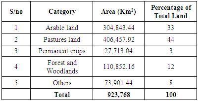
Nigeria 0ccupied 923,768 km² on the shoreline of West Africa as in the table beneath demonstrating that the land is the essential resource of county Nigerians with more than 80 percent being full-time agriculturists.
Table 1. Land usage category in Nigeria
     
Be that as it may, the business analyst and customary fiscally suitable considered the land as one of the factor of creation as work, capital, and entrepreneur. The land is never again been discussed as the seed-bearing outward or the physical structure put on it; it is likewise talked about as a space that involves all exercises which are really characterized and separated by reviews and organized from the characteristic world. Land management in the developing nation has been as of late draws consideration [2]. The primary reason cannot be overemphasis. The interest for land because of the populace growth, development and general exchange and mechanical development has expanded the cost of the land [2]. The heightening in the cost of property makes land registration more advantageous. At last, in decentralized landscape land administration backings to offer open merchandise and create government funds and add to developing rustic zones by more than the horticulture [2].
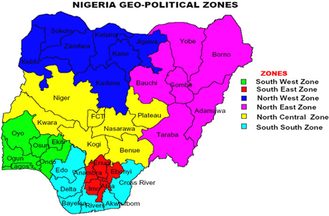
Figure 1. Map of Nigeria [3]
The Nigerian pre-Colonial land tenure system was so entangled than what we have today because each of the locales and the ethnic groups, and zones rehearsed distinctive standard system with social decent variety and geological arrangement. The colonial government in Lagos protectorate began the documentation of the formal rights and interests in 1863 and different parts in 1894 since land exchange was not having any official records before the colonial time frame. The land was viewed as the establishment for lodging, business, and nourishment. Colonial government Crown by intrusion, intimidation, bargain, cession, tradition or assertion obtained lands. The lands gained moved toward becoming state land after the colonial period [7]. The Native Land Acquisitions of 1900 and the Native Rights Ordinance of 1916 that built up formal land tenure system in Nigeria was used. The control of land was exchanged from the emirs to the CEO (the Governor) of the northern protectorate.
In this manner, land in the Northern district was subjected to the control of Governor for the advantage of the general population in that locale having made a law backing them from the federal government. It was difficult for the government to stop the distinctive residency system, fake and tricky practices in the land exchange [1]. Likewise, the government was not able to obtain land for developmental use. Accordingly, in 1978 the then Military Government declared a declaration (Land Use Decree of 1978). The Decree position of the land in the trusteeship of the state in order to make the land transport for formative reason faster. The state governors were approved to allow statutory rights of occupancy of settled periods in urban zones. What's more, the metropolitan administrator forces to concede a standard right of ownership (R of O) on the land in the rural area. The land tenure was nationalized in Nigeria because of the operation and standards of the Land Use Act 1978 (LUA). Surprisingly, the Act binds together the land tenure system everywhere throughout the country separated from the way that it's nationalized land in the country's geological Space [1]. Be that as it may, sadly, the Land Use Act neglected to meet the planned guarantees because of a few social and political reasons.
The disappointment and deficiencies in the usage of Land Use Act of 1978 prompted battling for the assessment by numerous partners. In an offer to build up the land administration system in Nigeria, the Government built up a Presidential Technical Committee (PTC) to leave on the change of all land tenure to address various issues emerging from Land Use Act of 1978. The PTC prepared to amend this and a few other to give registrable title to all land proprietors by inspecting the property laws to guarantee fair use of the land resources for monetary improvement [20].
The change is creative in the advancement and reception of Land Administration Domain Model (LADM) in the country’s land administration system. The (PTC) was accused of the obligations of making a guide for enhancing the current institutional, specialized, authoritative and lawful structure of the framework with a view to building up the land advertise for the alliance. It implies the Presidential Technical Committee will build up a National Depository for title possessions in all conditions of the Federation at the Federal Capital Territory and make an instrument for land an incentive in both urban and rural area. There will be the data bank for multipurpose cadastral in each state and the entire country. In another word, each state in the country will have the capacity to interface each other working a similar framework with the federal capital. It is one of the basic prerequisites for (LADM) conformance for a country profile.

4. LADM Packages

The three packages of LADM with one sub package is as follows;
Party Package, Administrative Package, Spatial Package.
(Surveying and Representation sub-package) [19].
Over viewing LADM packages, its core classes and present land administration system in Nigeria, LADM been an International standard ISO 19152 2012 provides an abstract conceptual reference model of packages linked to the people, parties, and organizations [17-19, 35]. Basic administrative units Rights, Restrictions and Responsibilities (RRR): Utility networks, spatial units, the building legal space, and parcel. Spatial sources surveying and spatial representations (geometry and topology).
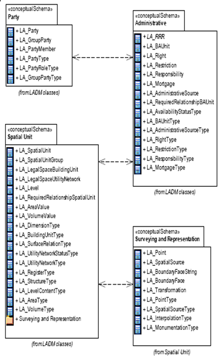
Figure 2(a). The Basic classes LADM and NG_Prefix Proposed: [17]
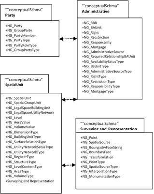
Figure 2(b). The Basic classes LADM and NG_Prefix Proposed: [17]

5. The Possibilities of LADM Adoption in Nigeria

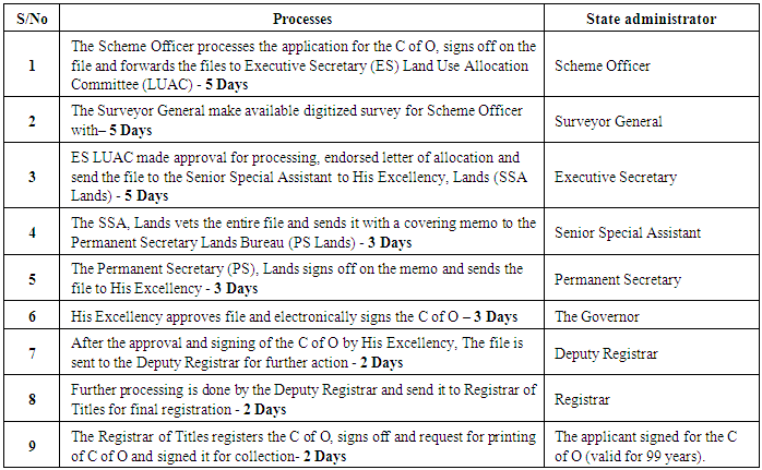
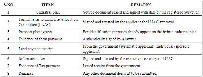
Validation can be the comparison between the real system when takes the form of comparison with the historical data when the actual system does not exist [31]. In another word, there is no existing formal model in the case of the Nigerian system, but the comparison was made based on the physical content of the land administration system in Nigeria.
A Party can be identified as a natural or non-natural person(s) in the title deed of the cadastral and land registration system in Nigeria. Also, the GroupParty and PartyMember can be identified [17]. Therefore, the NG_ prefix can be proposed for the classes in Party Package for the Nation's profile (NG_PartyMember NG_GroupParty and NG_Party). Another Party identified in the process to obtain the Certificate of Occupancy (C of O) is in the land registration in Nigeria. The Governor or the Commissioner for lands apart from the Ownership, Registered Surveyor or a Lawyer as the case may be is further identified as shown in figure 2 and figure 3. Legal, administration and the technical were also identified in other documents in land administration. The attributes in this package may be precisely applicable in the land administration system in Nigeria.
Table 2. The process of land Registration
     
Table 3. Document needed for Land Registration
     
LA_Rights, LA_Restriction, and LA_Responsibility are the three specialization classes of Administrative package and can be identified in Nigerian land administration and cadastral system. Parcel proprietors are given Rights (formal or informal) as a qualification to own. Restriction are constraining sure rights or prohibiting to play out a specific action to guarantee wellbeing [38], for instance denying a working to be worked inside specific meters of energy or fuel station. Duties might be to keep up a landmark as a commitment to do; the cases are keeping survey reference points and save those inside the locality. These are a piece of the substance of note which is kept in the register as encumbrance and rights antagonistically influencing the parcel. The BAUnit can be by and by considered as a conceptual in Nigeria land administration system since the land parcel is the Baunit in the title and land registration. The terms used as a part of Nigerian cadastral and land management system may not be a similar terminology with LADM by and by as apartment suite and so forth, however the model will give the beginning stage and a reasonable format to enhance the system in Nigeria. Or, on the other hand a discretionary specialization form might be considered. The prefix NG_Rights, NG_Responsibilities, and NG_Rectrictions might be considered for Country profile in the regulatory package of LADM for Nigerian [21].
The Spatial Unit class can be recognized in Nigerian cadastral plans/maps utilized as a part of the land titling and registration. Cadastral designs/maps can be identified as it was plotted from the data gotten from the field for the purpose of land registration; the data is accessible on each cadastral plan or map in the region where the parcel is found. The Building and utility systems are specializations of spatial units. A solitary or different land area, water or volume, single or various LA_SpatialUnit as the main core class [10].
Surveying and Representation sub-package, it is used for the identification and portrayal of the spatial units. The planned and structure of spatial units was done to keep up the development and administration of Basic Administrative Units. Surveying and Representation sub-package of the Spatial Unit Package with classes as LA_BoundaryFaceString, LA_Point, and LA_SpatialSource. Surveying is included in the distinguishing proof, the acquisition of point location of boundary and the investigation of spatial units. Boundary is the representation of the limit point of a spatial unit and can be represented as point (LA_Point), polyhedral (LA_BoundryFace) surfaces for 3D components and polygons (LA_BoundaryFaceString). A spatial source is a cadastral plan (NG_ SpatialSourceType) that gives realities about the spatial representation of one section or more spatial units which might be the last formal document or all reports identified with the survey. An orthophoto, geodetic control focuses, a satellite imagery with prove on the area of limits gathered from the field or a field survey sketch. [10] A spatial source might be scanned paper-based record, official or informal a aerial photo or registered survey design as found in figure 3. It is an indispensable piece of the cadastral and land administration system in Nigeria.
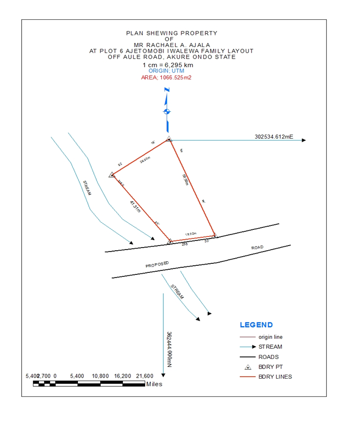
Figure 3. Source document (Nigerian Typical cadastral Plan)
LADM in this setting might be thought to be useful in the change of land administration system in Nigeria if embraced in light of the fact that having a brought together land administration system implies a bound together country profile for Nigeria. The cadastral system is comprised of various sorts of maps and plans. Boundary of lands are plotted from the coordinate of each land parcel in the survey plans, which are produced using lines when they are joined. The field data are acquired digitally in recent time and plotted carefully to acquire digital cadastral maps. Since surveying and spatial representation can be identified in Nigerian land administration system, the NG prefix for the classes are valued; NG_SpatialSource, NG_BoundaryFaceString and NG_Point [21]. Therefore, with regards to Nigeria land administration system, Surveying likewise includes the identification, obtaining of point (data) analysis and location of boundary of spatial units.
There are external classes that are outside the scope of LADM, yet provision was made in the informational collection which is normal from this external source in the generalization classes of LADM. The tax collection information, address information, valuation information, physical utility system information, external databases with party information, land cover information and land utilize information and document information are outside the extent of LADM. The case of these classes are as per the following: ExtTaxation, ExtPhysicalUtilityNetwork, ExtAddress, ExtParty, ExtValuation, ExtLandUse, ExtLandCover, and ExtArchive, they don't have LA_prefix. They gave a correct meaning of what LADM is anticipated from these external classes [10, 36, 37]. These are likewise found in the Nigerian land administration system with the exception of ExtPhysicalUtilityNetwork, which is not mainstream in her land administration system. Albeit, additionally look into is required in this area.
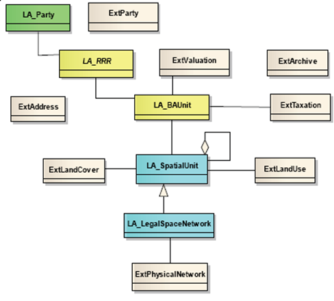
Figure 4. LADM and External Classes [32]
LADM maintained and managed the historical data in the database by the introduction of the Class Versioned Object [17]. The superseded and inserted data are given a time stamp. The database contents at any instant can be represented as they were and how they were. The Oid is introduced as the generic data type into the LADM to supply support for object identifiers. In normal, the retrieving, bring up-to-date, and administration of the database depends on correct source documents, which not possible to change. Nigerian land administration system have enough details in the plans and maps that can make likely the full adoption of LADM. Land administration is an activity that deals with the massive amount of data, many of which may need periodical maintenance and dynamic in nature. Title and land registration are time-stamps, the time, and the process of obtaining them to take years. Land property division, amendment, and certification also takes time. Therefore, the different classes of the land administration system have to be versions so as to keep all data in the database.
Table 4. Survey statistical data for LADM
     
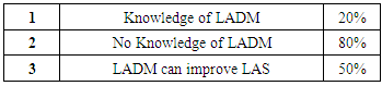
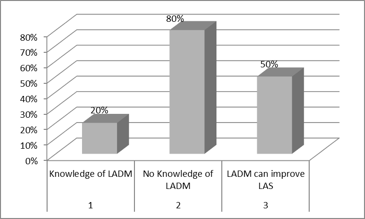
Figure 5. The Histogram of LADM evaluation in Nigeria

6. Analysis and Discussions

The survey conducted between May and August 2016 in the six geo-political zones and the Federal Capital of Nigeria demonstrates that 20 percent of the respondents have caught wind of LADM with little information, 80 percent have not found out about LADM and 50 percent trusted that LADM will enhance the cadastral and land administration system of the country (table 4 and figure 6). Subsequently, for assist improvement of LADM in the study area, there is a need to conduct users` requirements, workshop, and conferences which will include the vast majority of the partner in land administration. Be that as it may, the advantages and merits of LADM adoption in the study area can't be overemphasized.
LADM covers a wide range of tenures both formal and informal environment including self-composed cadastral and land administration system which is extremely regular in Nigeria because of numerous ethnic and convention the country over. It is adaptable in its execution and be adjusted to both local and the international [10]. LADM Nigerian country profile would be an advantage from the data of cadastral survey, tax collection, title registration, and land use connected together from various associations. Likewise, the spatial database joining with the literary database which is a prerequisite for the plan of land data system at all level, Local, State and the National will adequately enhance the cadastral and land administration system in Nigeria [39].The figures 6a and 6b underneath demonstrate source records and the proposed code records for surveying and Representation Sub package and Party Package while table 2 and table 3 in pervious section demonstrate the case as shown in code list respectively.

7. Conclusions

The primary motivation for this study started from the need to build up a model in other to rouse the product applications and advancement in other to encourage the selection of land administration for manageable improvement in Nigeria. Subsequent studying of the application and the conceptualization of LADM as a kind of perspective model that has fundamental data identified with components of land administration system. There is earnest need to fundamentally investigate the conceivable outcomes of adoption of LADM in Nigeria. Likewise from this study, it was uncovered that there was no plan or model for land administration system in Nigeria. In spite of the fact that from the study conducted, LADM is not yet so prevalent among the specialist and partners in land administration in Nigeria yet, there will be high mindfulness inside couple of years with edification from the workshop, conferences and paper publications.
Given this, this study begun with a record of land and land administration system in Nigeria. The exchanges was on pre-frontier, pilgrim and post-provincial time. It is done as a presentation for understanding the change required for LADM adoption in Nigeria. LADM, standard, and the packages were examined, and examination of the distinctive parts of each class and packages were made with Nigerian land administration system. In the evaluation made, it was uncovered that LADM is like the substance of Nigerian land administration and its policy. As indicated by this study, the terminologies utilized as a part of Nigerian land administration system are not the same by and large albeit some specialization might be presented and properly clarify in a rendition.
Subsequently, Nigerian land administration system can embrace the standard by mapping in LADM into their system since it was found from this study the standard is appropriate for the land administration of the country. The following action will be the means by which to sort out workshops and conferences, while our next study will be the advancement of LADM country profile for Nigeria. Nonetheless, this paper can be viewed as a base for characterizing the LADM country profile for the entire Nigeria.

ACKNOWLEDGEMENTS

The first author wish to acknowledge Ministry of Higher Education Malaysia (MOHE) and Universiti Teknologi Malaysia for funding this work GUP Tier 1 (PY/2016/06368-Vot. Number 15H61).

References

[1]  Atilola, O., (2010) Land Administration Reform Nigerian: Issues And Prospects, in FIG Congress 2010 Facing the Challenges – Building the Capacity. 2010: Sydney, Australia.
[2]  Babalola, S.O., A. Abdul Rahman, L.T. Choon, and P.J.M. Van Oosterom, (2015) Possibilities of Land Administration Domain Model (Ladm) Implementation in Nigeria. ISPRS Ann. Photogramm. Remote Sens. Spatial Inf. Sci., ISPRS Ann. Photogramm. Remote Sens. Spatial Inf. Sci. name; II-2/W2: p. 155-163.
[3]  Babalola, S.O., T.L. Choon, A.A. rahman, W. Ayeni, and G. AJayi, (2015) An Analysis of 3D Situation as a Prospect for (LADM) in Nigeria: A Malaysian Initiative., in International Conference on Science Engineering and social science. 2015: UTM Skudai, Johor Bahru, Malaysia.
[4]  Babalola, S.O., A.A. Rahman, and T.L. Choon, (2015) A Brief Review of Land Administration Domain Model and Its Temporal Dimension. Journal of Advanced Review on Scientific Research., Journal of Advanced Review on Scientific Research. name; Vol. 6, No.1 (ISSN (online): 2289-7887): p. 1-15.
[5]  Budisusanto Yanto, Aditya Trias, and Muryamto Rochmad, (2013) LADM Implementation Prototype for 3D Cadastre Information System of Multi-Level Apartment in Indonesia, in 5th Land Administration Domain Model Workshop. 2013: Kuala Lumpur, Malaysia.
[6]  Carneiro, A.F.T., D.A. Erba, and E.A.A. Augusto, (2011) Preliminary Analysis of the Possibilities for the Implementation of 3D Cadastre in Brazil, in 2nd International Workshop on 3D Cadastres. 2011: Delft, the Netherlands.
[7]  Chigbu, U.E. and M. Klaus, (2013) Insecurity-Generating System of Land Tenure and its Impact on Rural Development: Evidence from Uturu, Nigeria, in FIG Working Week 2013. 2013: Abuja, Nigeria.
[8]  Coetzee, D.E.T.a.S., (2013) Towards a profile of the land administration domain model (LADM) for South Africa, in Centre for Geoinformation Science, University of Pretoria, Pretoria, 0002,. 2013: South Africa.
[9]  FDIS, I., (2012) Geographic Information-Land Administration Domain Model. 2012, International standards.
[10]  FLOSSOLA. http://www.flssola.org. 2012.
[11]  GGIM, U. http://ggim.un.org/ggim_committee.html, http://ggim.un.org/4th%20HLF.html. 2016.
[12]  Inan, H.I., (2013) Associating External Land Use-Cover Information with LADM's spatial unit., in 5th Land Administration Domain Model Workshop. 2013: Kuala Lumpur, Malaysia.
[13]  Jürg Kaufmann and D. Steudler, (1998) Cadastral 2014 with the Working Group 1 of FIG Commission 7. 1998, FIG.
[14]  Kalantari, M., K. Dinsmore, J. Urban-Karr, and A. Rajabifard, (2015) A roadmap to adopt the Land Administration Domain Model in cadastral information systems. Land Use Policy, Land Use Policy name;49: p. 552-564.
[15]  Kalantari, M., A. Rajabifard, J. Urban-Karr, and K. Dinsmore, (2013) Bridging the Gap between LADM and Cadastres., in 5th Land Administration Domain Model Workshop. 2013: Kuala Lumpur, Malaysia.
[16]  Lee, B.-M., T.-J. Kim, B.-Y. Kwak, Y.-h. Lee, and J. Choi, (2015) Improvement of the Korean LADM country profile to build a 3D cadastre model. Land Use Policy, Land Use Policy name;49: p. 660-667.
[17]  Lemmen, C., (2012) A Domain Model for Land Administration. 2012, Technische Universiteit Delft The Netherland: The Netherland. p. 244.
[18]  Lemmen, C. and P.V. Oosterom, (2013) The Land Administration Domain Model Standard, in 5th Land Administration Domain Model Workshop 24-25 September 2013, Kuala Lumpur, Malaysia. 2013: Kuala Lumpur, Malaysia.
[19]  Lemmen, C., P. van Oosterom, and R. Bennett, (2015) The Land Administration Domain Model. Land Use Policy, Land Use Policy name;49: p. 535-545.
[20]  Mabogunje, A.L., (2007) Land reform in Nigeria: progress, problems & prospects, in Chairman Technical committee on Land reform. 2007.
[21]  Mader, M., H. Matijevi, and M. Roi, (2015) Analysis of possibilities for linking land registers and other official registers in the Republic of Croatia based on LADM. Land Use Policy, Land Use Policy name;49: p. 606-616.
[22]  Njepuome., A.P.C., (2011) Cadastra Land Imformation in Nigeria, in Workshop on New Developments in Cadastres,. 2011: Narobi, Kenya.
[23]  Paasch, J., P.V. Oosterom, Christiaanlemmen, and J. Paulsson, (2013) Specialization of the LADM - Modelling of non-formal RRR, in International FIG workshop on the Land Administration Domain Model. 2013: Kuala Lumpur, Malaysia.
[24]  Paasch, J.M., P. van Oosterom, C. Lemmen, and J. Paulsson, (2015) Further modelling of LADM's rights, restrictions and responsibilities (RRRs). Land Use Policy, Land Use Policy name; 49: p. 680-689.
[25]  Paixão, S., J.P. Hespanha, T. Ghawana, A.F.T. Carneiro, and J. Zevenbergen, (2013) Modelling Brazilian Indigenous Tribes Land Rights with ISO 19152 LADM., in 5th Land Administration Domain Model Workshop. 2013: Kuala Lumpur, Malaysia.
[26]  Paulsson, J. and J.M. Paasch, (2015) The Land Administration Domain Model – A literature survey. Land Use Policy, Land Use Policy name;49: p. 546-551.
[27]  Paulsson, J. and J.M. Paasch, (2015) The Land Administration Domain Model ? A literature survey. Land Use Policy, Land Use Policy name;49: p. 546-551.
[28]  Pouliot, J., M. Vasseur, and A. Boubehrezh, (2013) How the ISO 19152 Land Administration Domain Model performs in the comparison of cadastral systems: A case study of condominium/co-ownership in Quebec (Canada) and Alsace Moselle (France). Computers, Environment and Urban Systems, Computers, Environment and Urban Systems name; 40: p. 68-78.
[29]  Shin, Y.-H. and B.-Y. Kwak, (2013) A Review of Korean LADM based on the Cadastre Reform Project., in 5th Land Administration Domain Model Workshop. 2013: Kuala Lumpur, Malaysia.
[30]  Siejka, M., M. Slusarski, and M. Zygmunt, (2014) 3D+time Cadastre, possibility of implementation in Poland. Survey Review, Survey Review name; 46 (335): p. 79-89.
[31]  Sucaya, I.K.G.A., (2009) Application and validation the Land Administration Domain Model in a real life situation (A case study in Indonesia), in Masters thesis, T.N. International institute for geo-information science and earth observation enschede, Editor. 2009: The Netherlands.
[32]  Van Oosterom, P., L. Christiaan, and U. Harry, (2013) ISO 19152 2012, Land administration domain model published by ISO, in FIG Working Week 2013. Environment for Sustainability. 2013: Abuja, Nigeria.
[33]  Van Oosterom, P. and C. Lemmen, (2015) The Land Administration Domain Model (LADM): Motivation, standardisation, application and further development. Land Use Policy, Land Use Policy name;49: p. 527-534.
[34]  Van Oosterom, P., C. Lemmen, T. Ingvarsson, P. van der Molen, H. Ploeger, W. Quak, J. Stoter, and J. Zevenbergen, (2006) The core cadastral domain model. Computers, Environment and Urban Systems, Computers, Environment and Urban Systems name; 30(5): p. 627-660.
[35]  Van Oosterom, P., C. Lemmen, and H. Uitermark, (2012) Land Administration Standardization with focus on Evidence from the Field and Processing of Field Observations 1, in FIG Working Week 2012 Knowing to manage the territory, protect the environment, evaluate the cultural heritage. 2012: Rome, Italy, 6-10 May 2012.
[36]  Vučić, N., M. Roić, and D. Markovinović, (2014) Towards 3D and 4D Cadastre in Croatia, in 4th International Workshop on 3D Cadastres. 2014: Dubai, United Arab Emirates. p. 261-280.
[37]  Zhuo, Y., Z. Ma, C. Lemmen, and R.M. Bennett, (2015) Application of LADM for the integration of land and housing information in China: The legal dimension. Land Use Policy, Land Use Policy name;49: p. 634-648.
[38]  Zulkifli, N.A., A. Abdul Rahman, P. van Oosterom, L.C. Tan, H. Jamil, C.H. Teng, K.S. Looi, and K.L. Chan, (2015) The importance of Malaysian Land Administration Domain Model country profile in land policy. Land Use Policy, Land Use Policy name; 49: p. 649-659.
[39]  Zulkifli, N.A., A.A. Rahman, and P.V. Oosterom, (2013) Developing 2D and 3D Cadastral Registration System based on LADM illustrated with Malaysian Cases, in 5th Land Administration Domain Model Workshop. 2013: Kuala Lumpur, Malaysia.