-
Paper Information
- Paper Submission
-
Journal Information
- About This Journal
- Editorial Board
- Current Issue
- Archive
- Author Guidelines
- Contact Us
American Journal of Geographic Information System
p-ISSN: 2163-1131 e-ISSN: 2163-114X
2017; 6(3): 103-110
doi:10.5923/j.ajgis.20170603.03

Ecofriendly Site Analysis for Rainwater Harvesting Potential Using Geo-informatics: The Case from Selected Zones of Ethiopian Somali Regional State, Eastern Ethiopia
 Abstract
 Reference
 Full-Text PDF
 Full-text HTML
Tsegay Weldu Hailu1, Weldegebriel Mebrahtu Gebregergis2
1Department of Water Resource and Irrigation Engineering, Jigjiga University, Jigjiga, Ethiopia
2Department of Geography and Environmental Studies, Jigjiga University, Jigjiga, Ethiopia
Correspondence to: Weldegebriel Mebrahtu Gebregergis, Department of Geography and Environmental Studies, Jigjiga University, Jigjiga, Ethiopia.
| Email: |  |
Copyright © 2017 Scientific & Academic Publishing. All Rights Reserved.
This work is licensed under the Creative Commons Attribution International License (CC BY).
http://creativecommons.org/licenses/by/4.0/

The availability of erratic rainfall and high evapo-transpiration causes temporal and spatial variability of water thereby manifesting food insecurity. For mitigating this problem, rainwater harvesting technology is advisable and governments are trying to use it at different times making interventions and investments. This study was conducted in the Ethiopian Somali Regional State with an overall objective of pinpointing the potential rainwater harvesting areas using Geo-technologies in combination with socio-economic surveys. Data were collected from both primary and secondary sources including their respective characteristics of the sources. The primary data collection instruments employed were: distributing questionnaire, field observation, GPS survey and focus group discussion. In addition, secondary data was also collected from reviewing numerous documents and image analysis. To carry out integrated rainwater harvesting potential site identification, five criteria maps were used based on their respective standards in the ArcGIS 10.1 software interface viz., Land use, Slope, Soil depth, Rainfall and soil texture. Each of these parameters were analyzed using various tool sets of the ArcGIS software and overlaid to produce an aggregate rainwater harvesting potential site. The finally weighted map shows the appropriate sites for rainwater harvesting technology which shows that 48.6% of the total area under study belongs to very high and high suitability classes while 3.3% is low suitability. The remaining 48.1% is under medium suitability category. The suitability maps are helpful to an ease understanding of identifying prominent areas for rainwater harvesting subjected to ease modifications if a need to incorporate other criteria is raised. Therefore, potential site identification for rainwater harvesting using geo-informatics is flexible, time efficient and cost effective method for facilitating decision making of rainwater harvesting interventions.
Keywords: GIS, GPS, Suitability analysis, Criteria maps, Water
Cite this paper: Tsegay Weldu Hailu, Weldegebriel Mebrahtu Gebregergis, Ecofriendly Site Analysis for Rainwater Harvesting Potential Using Geo-informatics: The Case from Selected Zones of Ethiopian Somali Regional State, Eastern Ethiopia, American Journal of Geographic Information System, Vol. 6 No. 3, 2017, pp. 103-110. doi: 10.5923/j.ajgis.20170603.03.
Article Outline
1. Introduction
- Water is essential for development, bio-diversity, environment, agriculture and all types of living organisms. Presently, fresh water availability has become world human right issue due to continuous depletion of fresh surface and groundwater resources. World’s quarter population living in developing countries is facing the harsh scarcity of water for domestic and agricultural purposes (Ahmad et al., 2010). Globally, the absence of fresh water is a treat to over 1.2 billion people for physical water shortage and 1.6 billion for economic water shortage (FAO, 2007). Even the prevailing fresh water is currently faced with problems related to climate change, population growth, industrialization and urbanization globally (Mwenge et al., 2008).Rainwater harvesting is an important alternative to freshwater sources, where currently freshwaters are pressurized due to pollution and over-utilization. This system is currently exercised by many countries of the world mainly countries of the African and Asian continents (HRDC, 2007; Baker et al., 2007). This technology is relatively cheap and pollution free as rainwater is collected before its interaction with the ground which is a major source for pollution. Hence, the only possible pollution and contamination of the water collected using this technology would be the atmosphere or the unhygienic conditions of collecting devices (HRDC, 2007). To enhance the livelihood of rural poor people, performance maximization for rain fed agriculture is advisable by using rainwater harvesting technology, an alternative for water availability during dry times. Rainwater harvesting is all about collecting rainwater from surfaces and storing in physical structures or soil profile (Beddington, et al., 2012). The rainwater harvesting techniques most commonly practiced in Ethiopia are runoff irrigation (run-off farming), flood spreading (spate irrigation), in-situ water harvesting (ridges, micro basins, etc.) and roof water harvesting (Meselech, 2014). Mostly, water collected in ponds is used for growing vegetables and fruits around homesteads for markets and home consumption.Ethiopia, located in the horn of Africa is mainly depending on agricultural productions provided that 60% of its total GDP, 88% of its export earnings and large employment opportunities belongs to this economic activity. The country, with an estimated population number of 90 million is still food insecure due to its dependence on rain fed agricultural system subjected to rainy season durations and amount of rainfall variations leading to low yield productivity and low income generation. Ethiopia, considered as the water tower of east Africa, indicating the potential availability of water resources, high amount of runoff mostly by trans-boundary Rivers is its major challenge (CSA, 2007). Had it been effectively utilized, the potential is owed to support large number of people which is not still implemented at the expense of current attempts of water resources utilization which is very limited. For example, only 5% out of its irrigation suitable land is irrigated, limited number of large scale dams are still implemented subjected to their expensiveness. Most of the available rivers are also still not well utilized contributing rain fed agriculture to be the main stay of its economy and livelihood. The economy of Ethiopian Somali Regional State owning a total area of 350,000km2 and a total population of around 5million (CSA, 2007) like other states, is predominated by agriculture (including crop production and animal rearing) in which the latter is the mainstay. As this is mainly water dependent economy basically rainfall which varies temporally and spatially, the livelihoods is exposed for food insecurities (Somali Region, Program of Plan to Adapt to Climate Change March 2011).Being life in Ethiopian Somali Regional State is mainly dependent on pastoral and agro-pastoral activities (the former is dominant), problem of food security prevails due to water scarcity and variability leading the life to be movable in search of pasture and water for their livestock. This results for the problem of providing services like schools, health services and other infrastructures.The main intention of this research was therefore, to narrow this problem by providing potential sites for water harvesting so that ways will be sought to reverse the problem.
2. Study Area
- Ethiopia Somali regional state (which is one of the nine administrative regions of Ethiopia) is geographically extending from Southern to Eastern parts from 4 to 11° N latitude and 40 to 48° E longitude (EVDSA, 1991). The climatic condition varies from arid/semi-arid (lowlands) to cooler/wetter (highlands) areas. Its annual rainfall also varies from 500 – 1000mm with an average of 500mm (SCUK/DPP, 2004). Depending on season, the region is divided in to north (containing Siti and Fafan zones) and south (having the remaining seven zones) owning a bi-modal rainfall pattern occurring from March – May and July – October (IPS, 2002). The major perennial rivers in the region are Wabi Shebelle, Genale, Dawa and Weyib while Erer, Daketa and Fafen are seasonal rivers. The estimated irrigation potential of the region is over 600,000 ha of land, out of which, currently, only 1.5% is irrigated.
3. Methodology
- Rainwater harvesting site identification is a multifaceted phenomenon requiring an integrated analysis of different parameters in which environmental factors took lion share. So, the main environmental parameters considered during this research were basically: Land use Land cover, Slope, Soil data (texture and depth) and Rainfall. Hence, data related with these parameters were collected from sources using data collection instruments. A mixed research design approach was used to analyze these factors since it helps to triangulate the sources and outputs. This design was also important to inculcate those criteria maps together so as to develop a comprehensive research output. For each environmental factor, a suitability map was developed in the GIS software interface using the applications of toolsets. After having each factor suitability result, they were overlaid and weighted to produce an aggregate potential site for rainwater harvesting.
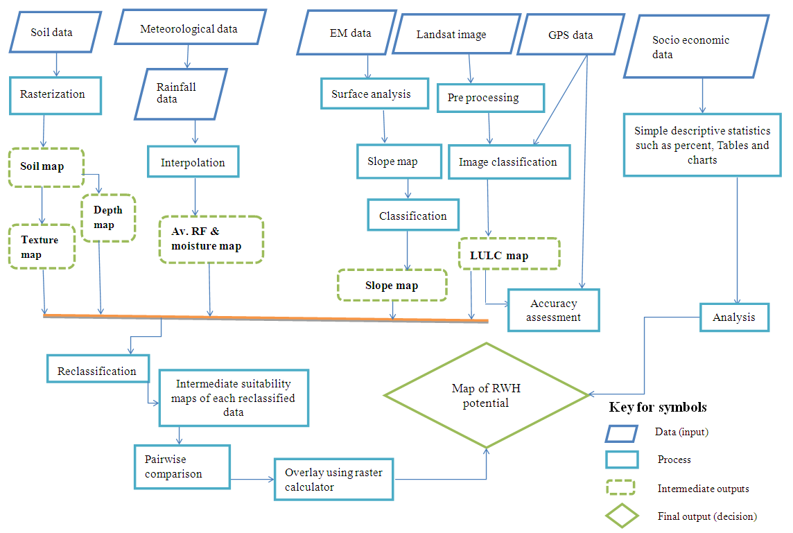 | Figure 1. General work flow chart |
4. Method of Data Analysis
- Data collected from desired sources were analyzed using the applications of various ArcGIS toolsets of the ArcGIS toolbox based on their nature of analysis. Accordingly, LULC was acquired from Landsat imageries and held analysis including pre-processing to actual classifications using maximum likelihood classification algorism followed by reclassification system. Slope which was extracted from DEM data was analyzed using surface analysis of the spatial analyst toolbox. Soil data was also proceed through rasterization process so as to get texture and depth based soil criteria maps. The rainfall data was also collected from meteorological stations that an interpolation technique (IDW) was applied followed by classification and reclassification systems. Having analysis of each criteria map, they were integrated and compared using pairwise comparison technique followed by weighted overlay analysis using raster calculator. The socio-economic data collected from observations, questionnaire and interview on the other hand were also analyzed statistically providing supporting information for the environmental parameters dependent integrated output.
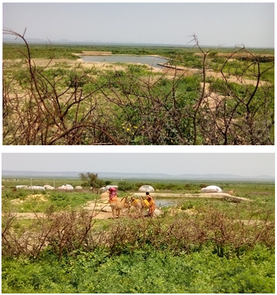 | Figure 2. Design structure (a) and use of the harvested water (b) |
5. Results and Discussions
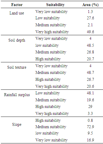
- Potential site identification analysis for rainwater harvesting was done by ArcGIS 10.1 software using the applications of different tool sets which is a multi-criteria in nature leading for the use of multi-criteria evaluation. The survey results also indicated that most of the constructed ponds in the selected zones have considerable seepage due to site selection problems. In addition, most surveyed ponds also have silt problems because of lack of having trapping structures indicating the prevalence of design problems. The survey analysis and observation also reveals that, different rainwater harvesting structures are prevailing currently which are mostly at community level and supported by the government. The community ponds are lined (with rectangular shape of 6-12m wide with 3-6m deep) and unlined (which are very shallow, wide and fenceless). Since some of the ponds are with no silt trapping structure, they are vulnerable for siltation fill. The community uses the harvested water for different purposes like drinking animals, washing, cooking and others.After development of the design and physical structures, operation and maintenance belongs to the owners which they are thinking as it is the responsibility of the one who construct the system. As a result, most ponds currently function below their potential since they are not properly maintained and repaired timely making the structures not to deliver their potential to the expected level.After analysis, suitable sites were identified using ArcGIS 10.1 by integrating different input criteria maps. The identification analysis was multi-objective and multi-criteria in nature. The criteria maps selected (Land Use, Soil depth, Soil texture, Rainfall surplus and Slope) were analyzed based on the standard suitability classes developed by FAO. Accordingly, their respective result is discussed here as follows. The Land use Land cover map was analyzed and generated from Landsat imageries by resampling to 15m resolution. The land cover analysis provides four land classes including: Urban/Wetland, Woodland, Grassland/Shrub land and Bare land/Cultivation lands that belongs to Very low suitability, Low suitability, Medium suitability and Very high suitability respectively according to the standard used. Accordingly, taking the land cover criteria in to consideration: 1.3%, 27.6%, 2.1% and 49.6% of the total area was Very low suitable, Low suitable, Medium suitable and Very high suitable respectively. Soil depth was extracted from FAO soil data and rasterized using depth value to get soil depth map. It was reclassified based on the derived standard to have four suitability classes of high, medium, low and very low suitability comprising a percentage share of 20.7%, 26.8%, 48.5% and 4% respectively. Similarly, the soil data was rasterized using texture followed by reclassification so that Very low, Medium, High and Very high suitability classes with their respective percentage of area coverage 4%, 48.7%, 26.7% and 20.6% were generated. Rainfall surplus map was generated by interpolating five rainfall surplus point values calculated as P – ET (precipitation minus evapotranspiration) using the data from five meteorological stations. The calculation was done for each station and month that rainfall surplus was generated by adding all the positive values of the difference starting from rainy season. To get a surface map of rainfall surplus, the calculated values were interpolated using the Inverse Distance Weight (IDW) interpolation method of Arc GIS 10.1. The interpolated rainfall map was reclassified depending on the suitability classes identified giving Low, Medium, High and Very high suitability classes sharing 48.1%, 19.6%, 29% and 3.3% of the total area under investigation respectively.
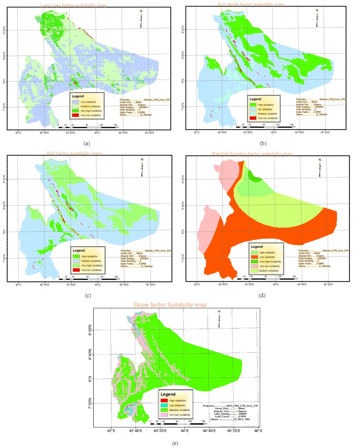 | Figure 3. Suitability analysis of the Criteria Maps: Land use (a), Soil depth (b), Soil texture (c), Rainfall surplus (d) and Slope (e) |
|
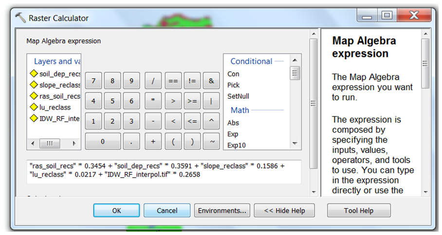 | Figure 4. Raster calculator of the spatial analysis tool box used for producing the final map |
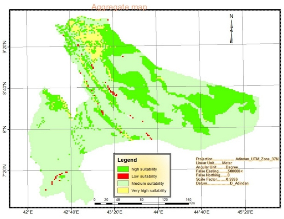 | Figure 5. Weighted overlay map of Rainwater Harvesting potential |
6. Conclusions
- Rainwater harvesting implementation may be debatable if assessment and site identification would not carry out by considering multi-criteria approaches. It is evidenced that some of the sites identified so far in different parts of Ethiopia in general and study area in particular, are failed due to improper selection of the sites. Despite of the availability of water harvesting manuals explaining about site selection, type and design, suitability analysis using geo-technologies is with far reaching importance. Currently, harvesting sites are simply selected to satisfy the quota based distribution of woredas regardless of the guidelines given. As a result, sites are selected improperly with respect to the soil availability, design, absence of farmer’s participation in planning and implementation. Effective utilization of runoff water is important for enhancing the sustainability and acquiring rain fed related activities like farming activities, pasture availability for animal feed and others. Hence, information delivering through identification of potential sites for rainwater harvesting is important step preceding to the actual preparation and execution. In this study, potential areas of rainwater harvesting were identified using ArcGIS10 software applications applying the multi-criteria evaluation approach to combine the effects of different environmental variables (slope, soil texture, land use, soil depth and rainfall surplus). A separate suitability analysis was done for each criteria maps which produces an aggregate potential map for rainwater harvesting. Hence, large part of the study area belongs to suitable class while insignificant share is not suitable. Based on the aggregated suitability map: 29%, 19.6% and 48.1% of the study area belongs to very high, high and medium suitability classes while the remaining 3.3% is under low suitable. The analysis gives a great advantage of optimum development for rainwater harvesting sites since it shows those areas which are conducive for the development. It also helps to direct the future development of rainwater harvesting sites thereby protecting other land uses at the same time. In general, the result of suitability analysis gives an important conception about the interactions existed among the factors. It enables to make an informed decision about the environmental conditions and thus, more sustained quality of life for the community and the surrounding ecological environment. Therefore, suitability analysis is a powerful tool for rainwater harvesting site identification and planning. Since, the application of GIS is a new and flexible technology for suitability analysis, refinement is possible when a need arises.
ACKNOWLEDGEMENTS
- First and for most our great pleasure goes to the JJU research, publication and technology transfer directorate office for being funding and giving required support for the success of this research. We would also like to express our sincere and whole gratitude to the respondents for their esteemed and genuine response they provide which plays a vital role for the output of this research. We would like to express our acknowledgement to all offices: Ministry of Agriculture (MoA), Ministry of Water Resource and Energy (MoWRE) and National Meteorology Agency (NMA) who provide us necessary data and other important documents useful for the success of this research work.