-
Paper Information
- Paper Submission
-
Journal Information
- About This Journal
- Editorial Board
- Current Issue
- Archive
- Author Guidelines
- Contact Us
American Journal of Geographic Information System
p-ISSN: 2163-1131 e-ISSN: 2163-114X
2017; 6(3): 90-102
doi:10.5923/j.ajgis.20170603.02

Implementation of Geographic Information System Application in the Maintenance Management of Roads in Ghana: A Case Study of Roads in Kumasi Metropolis
 Abstract
 Reference
 Full-Text PDF
 Full-text HTML
1Civil Engineering Department, Faculty of Engineering and Technology, Kumasi Technical University, Kumasi, Ghana
2Geomatic Engineering Department, College of Engineering, KNUST – Kumasi, Ghana
Correspondence to: P. C. Acquah, Civil Engineering Department, Faculty of Engineering and Technology, Kumasi Technical University, Kumasi, Ghana.
| Email: |  |
Copyright © 2017 Scientific & Academic Publishing. All Rights Reserved.
This work is licensed under the Creative Commons Attribution International License (CC BY).
http://creativecommons.org/licenses/by/4.0/

One of the challenges for road maintenance engineers in Ghana over the years is inadequate funding for road maintenance and development. This has resulted in the poor state of roads in some part of the country. This notwithstanding, the ministry of roads and highways and its allied departments and agencies works collaboratively to create accessible, effective and efficient transport network that meets users’ needs. In order to maintain roads in optimum condition with the limited budget and maximise the benefits of a transportation program to its users, a decision support system is essential. The paper highlights the need to implement GIS as a decision support system in road maintenance and development in Ghana. The paper also presents a methodology and system development of a customised GIS based decision support system for road maintenance management. Two application modules were developed, geodatabase of road in GIS environment and visual road condition database in SQL database engine. Visual basic application was used to integrate these two application modules into a common platform. Finally the network was prioritised using multi-criteria decision analysis. Decision makers can therefore plan and prioritise the road maintenance needs in more conventional way thereby utilising the allocated budget efficiently and effectively.
Keywords: Geographic information system, Road maintenance, GIS application, Pavement management
Cite this paper: P. C. Acquah, C. Fosu, Implementation of Geographic Information System Application in the Maintenance Management of Roads in Ghana: A Case Study of Roads in Kumasi Metropolis, American Journal of Geographic Information System, Vol. 6 No. 3, 2017, pp. 90-102. doi: 10.5923/j.ajgis.20170603.02.
Article Outline
1. Introduction
- Road network infrastructure constitutes major part of inland transportation system in Ghana. It is estimated to account for over 95% of all passengers and freights traffic and reaches most communities in the country. Efficient and reliable urban road transportation system therefore has the potential to promote growth and reduce poverty in the urban communities. This makes urban road infrastructure one of the important assets for socio-economic development in the country. Ghana’s road transport infrastructure as inventoried at the end of 2011 was 68,067km linking the entire country, comprising 13,367km of trunk roads, 42,100km of feeder roads and 12,600km of urban roads. Urban road network which represents about 18.5% of the entire network infrastructure plays very significant role in the national development since majority of economic activities take place in the urban communities in the country. The major problem confronting road managers in Ghana and in many developing countries especially in the sub Saharan region is the issue about inadequate funding for road development and maintenance. Inadequate road maintenance causes irreversible deterioration of road infrastructure thereby preventing the realisation of the long term impacts of road improvements on national development, such as increased agricultural production, access to markets and health facilities (Wasike, 2001). Roads in poor condition increases accident rate and their associated human and property cost and aggravate isolation. Studies have shown that roads in poor condition constrain mobility and significantly raise vehicle operating costs (Burningham and Stankevich, 2005). According to Heggie and Vickers, 1998, when road is allowed to deteriorate from good to poor condition, each dollar saved on road maintenance increases between $2 and $3. The importance of road maintenance is therefore seen as a priority by decision makers and policy implementers. The challenge for road maintenance engineers in Ghana over the years has been with inadequate budget for road maintenance and development. For example, it is estimated that GH¢600 million is needed every year for sustainable road maintenance but currently only Gh¢250 million representing a little below 50% is allocated for roads maintenance and development. A recent Ministry of Roads and Transport report in 2015 revealed that in 2014, Gh¢225.61 millon was budgeted for road maintenance as against an expenditure of Gh¢490.99 million. This notwithstanding, the ministry and its allied departments and agencies are working collaboratively to keep roads in good shape in order to create accessible, effective and efficient transport network that meets users’ needs. The mandate of the ministry is to develop policies, strategies and programmes for effective development and maintenance of roads. Such an effort requires a well structured decision support system that can facilitate the capture of relevant information about the road infrastructure, manipulate it and present the results in a format that will assist road managers in taking meaningful decisions. In order to maintain roads in optimum condition with a limited budget and maximise the benefits of a transportation program to its users, a decision support system is essential. One of the means that has been explored extensively is the integration of GIS in pavement need analysis (Zhou et al 2009; Zhou et al 2012, Coutinho-Rodrigues et al 2011; Zhang et al 2012). Geographic Information System (GIS) and its allied technologies such as Global Position System (GPS) and remote sensing have been very instrumental in the policy decision making processes especially in areas where spatial information is needed to shape and influence the context in which decisions are made (Bham et al., 2001). Adeleke et al, 2015, recommended that in order to enhance the decision making processes, road agencies should consider the use of GIS for pavement maintenance management and further explain the use of GIS as a spatial technology is appropriate for pavement maintenance management since the primary data used in the decision making process have spatial components.GIS applications in network-level pavement needs analysis systems have received much attention in recent years (Zhang et al 2012). In contrast, road management agencies in Ghana have not integrated GIS technology in management activities despite its numerous advantages. Road infrastructure development and management involves the application of engineering, financial administration and management practices. In order to optimise the level of service outcome in return for the most cost effective financial input, a well structured programme for maintenance is essential. The objective therefore is to get a programme that will assist maintenance engineers to apply the right treatment at the right time to achieve the desired level of service. The expensive and the cumbersome nature of road management software make it difficult for many developing countries to acquire, operate and maintain without support from donor agencies and developing partners. There are many localised application software in GIS that have yielded favourable results in other jurisdictions; Road Measurement Data Acquisition System, ROMDAS, implemented in Abu Dhabi Island, Visual IMS, a GIS integrated Infrastructure management system, Pave Plan Real Time PMS in Sonata County, Pavement Surface Evaluation and Rating, PASER, Pavement Performance Prediction Modelling, PAVER and PAVENE implemented in Singapore (Parida, 2005; Haas etal 1994; Elhadi 2009; Kmetz 2011; Shahin 2005; Fwa et al 1994) are some useful GIS applications in other jurisdictions. The need therefore is to develop and implement a user friendly, cheap and simplify spatial decision support system that can provide the needed information for road managers to apply the required treatment at the right time based on the available budget. The paper highlights the need to implement GIS in road maintenance and development in Ghana and also present a methodology and system development of a GIS based decision support system for road maintenance management.
2. Road Network in Kumasi
- Kumasi, the administrative capital of Ashanti region and the second largest city in Ghana is touted to be the hub of Ghana’s transport system. Almost all the major roads in Ghana from North to the South, East to West pass through the city. The radial nature of road network in the city of Kumasi, shown in figure 1, is such that all the major arterial roads converge at the centre of the city. Due to its nodal position, roads in the city do not only serve people in the metropolis but the entire country and the neighboring countries as well.
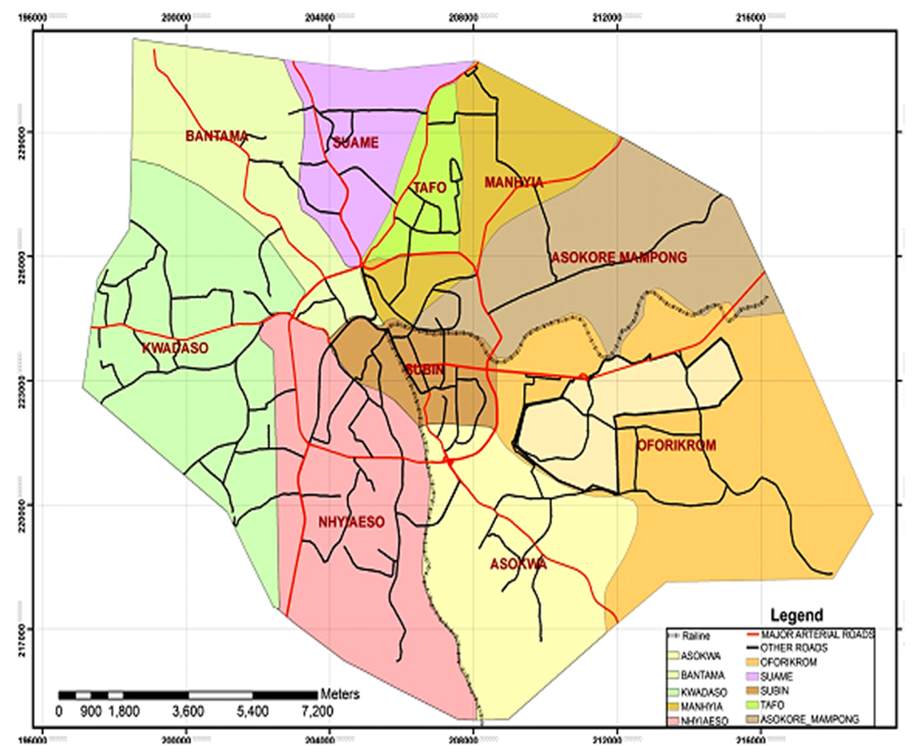 | Figure 1. Major road network in Kumasi |
3. Pavement Management System (PMS) and GIS
- Pavement Management System (PMS) is a set of defined procedures for collecting, analyzing, maintaining and reporting pavement data to assist decision makers in finding optimum strategies for maintaining pavements in serviceable condition over a given period of time for the least cost (Shahin, 2002). The primary purpose of PMS therefore is to aid decision makers and policy implementers in making decisions about what, where and when a treatment is needed. A more comprehensive pavement management models require a diverse collection of road related data, including pavement condition surveys, skid resistance measurements, traffic counts, bridge inspections, sign inventories, accident investigation, construction and maintenance records, inventories of signs and roadside obstacles (Venkata, 2005). Although some of these data may be available in digital format, they may be inconsistent and duplicative in nature and typically unrelated to each other in terms of format and projections. The challenge is that the files may have been created independently from different sources using different referencing systems and computer formats. In some instances the data required for analysis may not be spatially referenced at all, as a result, they are difficult to be used as inputs to a PMS.Studies have shown that PMS with spatial application capabilities can be implemented as decision support tool in the protection and management of investment (Flintsch and Chen, 2007, Ibraheem & Falih, 2012). GIS technology is proposed as a framework for these data integration because it provides a means of relating data collected under various referencing systems. With GIS, variation in road conditions (good, bad or fair) and road surface types (paved or unpaved) can be shown dynamically on a map. Figure 2 outlines the conceptual GIS based road maintenance database module. In a typical GIS application, the input data is very essential since it determines the kind of analysis the user can perform and the expected results when the system is queried. GIS provides the ability of combining tabular information from road pavement condition in a database and spatial information of road network represented by maps into a common platform. This capability and other analytical functions of GIS allow users to comprehend and absorb information from maps more quickly and effectively than from a list of road records in a tabular format that PMS provides.
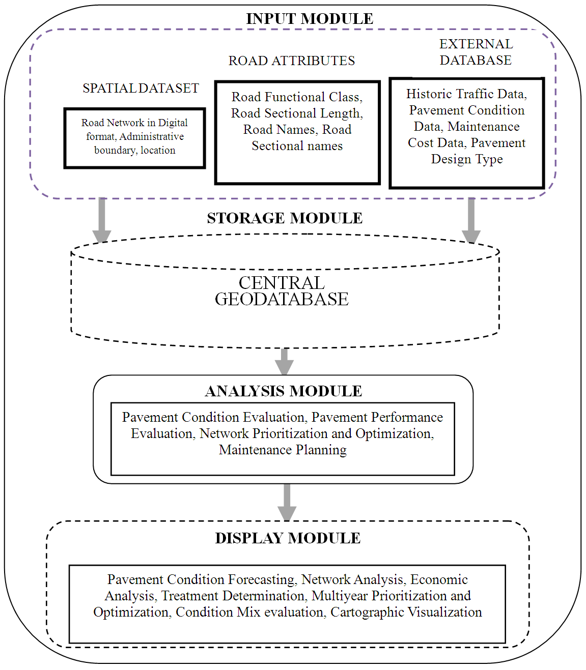 | Figure 2. Conceptual GIS based road management system |
4. The Application Development
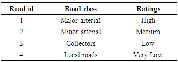
- The GIS based pavement management information system developed is a spatial decision support system that integrates road maintenance database in a Structured Query Language (SQL) Server database engine and spatial database in ArcGIS environment. Two major application modules were developed and integrated into a common platform with visual studio application for pavement performance evaluation, analysis and forecasting. The following subsections further explain the module development. Spatial datasets used for the of GIS module development were extracted from road network map of Kumasi metropolis through the process of digitising. Deduct values representing the numerical ratings of road pavement distresses from visual road condition survey and Annual Traffic Data (ADT) obtained from maintenance section of Urban Roads department were the main sources of data in the road maintenance database. The spatial database was then integrated into the road maintenance database to create a spatial decision support system. The following subsections further describe the application development. Spatial Data Preparation and EntryThe road network map was digitised by encoding the needed data into the GIS environment for further analysis. The road features, the administrative boundary of the metropolis, railway lines and the locations of towns were the main feature classes encoded from hard copy maps collected. The features were edited and the relevant attributes added into the system. The network was then put into sections and linearly referenced. In the GIS environment, the relevant data needed to form the core of the database the road network were created. The following attributes were considered and implemented in the geodatabase; Ÿ Road functional class: this is an important attribute of the road because it gives the overall importance of the road. The classes identified in the metropolis were the Principal Arterial roads, Minor Arterial roads, collectors and local roads. Ÿ Road names: The road names were also added to the network for easy identification and data retrieval. Ÿ Road surface types: the road surface types identified in the city were the Asphalted Concrete (AC), Bituminous Surface Treated (ST) and Gravel roads (GR). Other attributes such as road sectional names and sectional lengths were also added. Road SectioningThe network was divided into a series of sections for easy referencing and identification. The sections are the basic unit of road network used for management purposes. The sections were further divided into subsections for detailed analysis of road condition and prioritisation. The sections were carefully selected to have homogeneous characteristics with the following being typically uniform: road class, level of traffic, road geometry and pavement construction type. Each section was given a unique identity and for purpose of identification, the sections were given unique reference number comprising the following; the unique road and link numbers, the metropolitan and sub metropolitan identities and the road class. For example, the reference number "KU-KW-B-0010-001" as indicated in figure 3, refers to a section in the metropolis and it is within the Kwadaso sub-metro with road number 0010 and a link number 001 with a class of B signifying minor arterial.
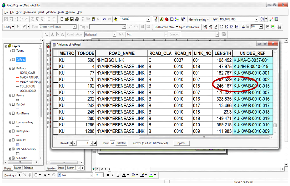 | Figure 3. Road sections and names |
 | (1) |
|
5. The System Architecture
- The GIS based road maintenance application system architecture shown in figure 6 typically explains the components and system development. Currently, maintenance engineers assigned to the various sub metros in the city periodically submit report of roads in the network that need maintenance based on periodic visual road condition inspection for consideration by management. Management upon further consideration and deliberations will select from the list submitted, the roads that can be maintained or rehabilitated based on the available budget and the condition of road.This ad-hoc way of managing roads leave some roads unattended to and does not also bring equity into the road management programme. The proposed GIS system intends to cure this deficit in the management cycle. The GIS based road maintenance application first takes inputs from the results of visual road condition survey and Annual Average Daily Traffic (AADT) data as a core data into the main road maintenance database. The road maintenance database in the SQL database engine platform is integrated with the geodatabase in the GIS environment with visual basic application. The data entry forms in figures 4 and 5 are used to capture the visual road inspection data of various pavement distresses into the road maintenance database for the condition score evaluation and description for both paved and unpaved road respectively. Figure 7, the traffic data entry form designed in the system is also used to capture the AADT values into the system database be factored into the prioritisation processes.
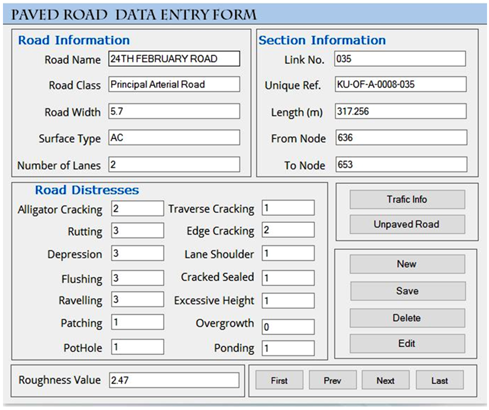 | Figure 4. Paved road data entry forms |
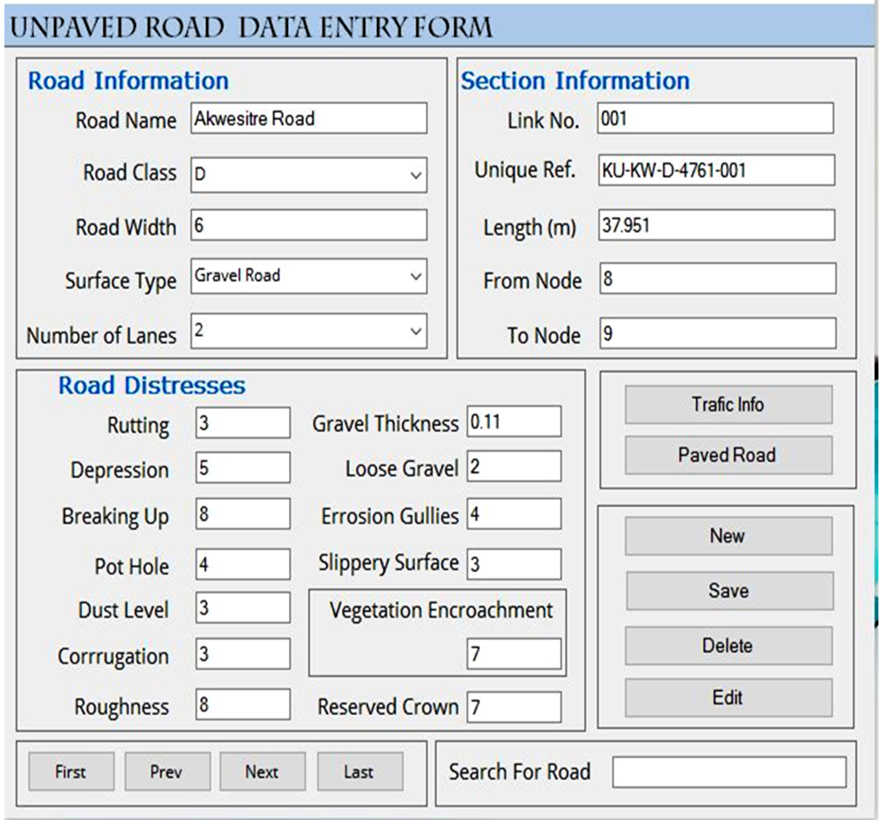 | Figure 5. Unpaved road data entry forms |
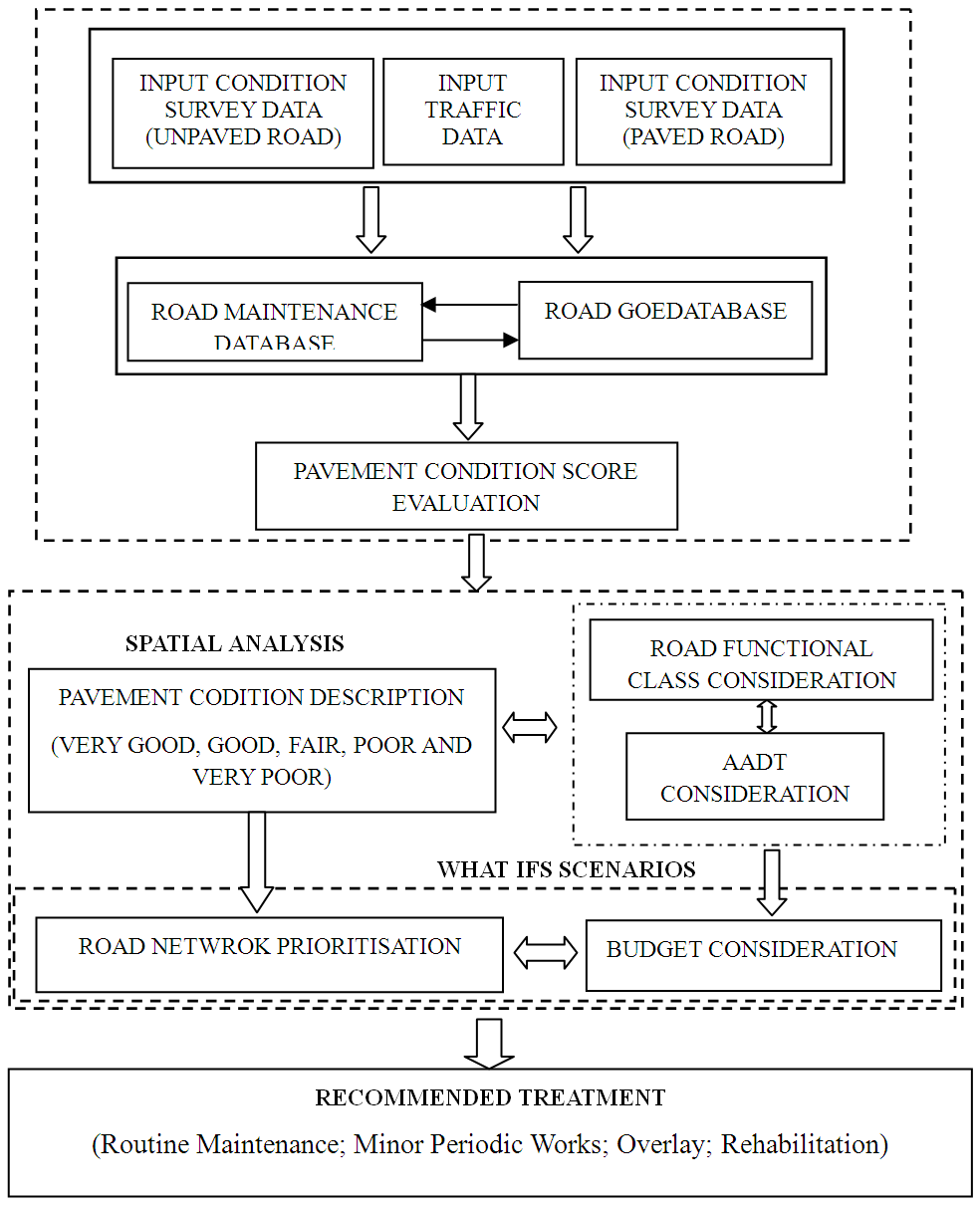 | Figure 6. GIS based pavement management system architecture |
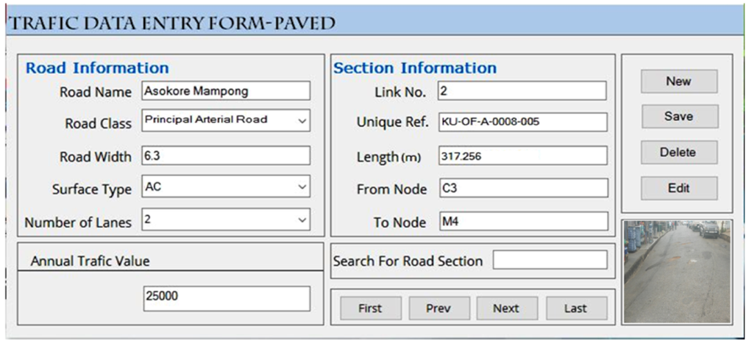 | Figure 7. Traffic data entry forms |
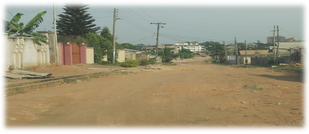 | Figure 8. Unpaved road in poor condition |
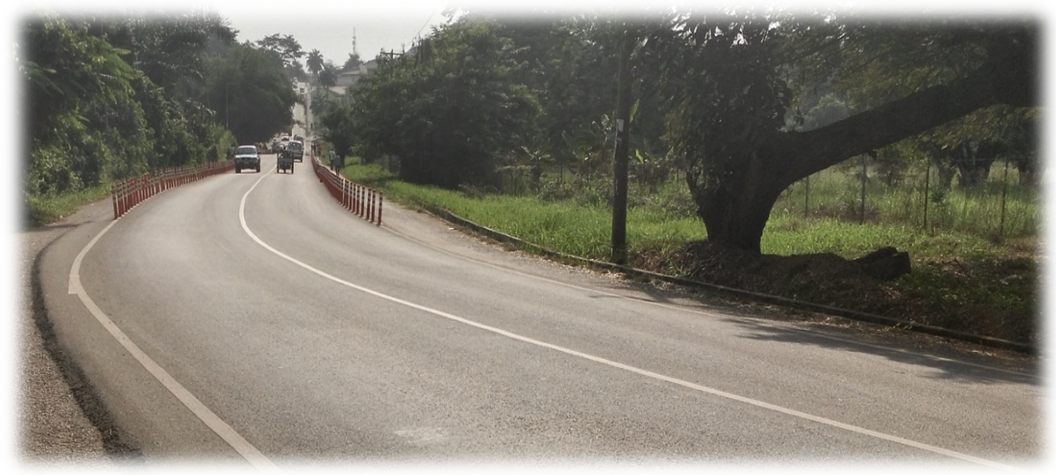 | Figure 9. Paved road in good condition |
6. Application Testing and Results
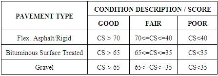
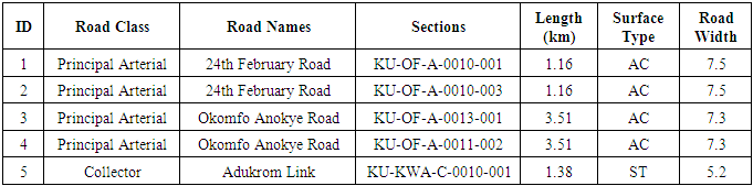
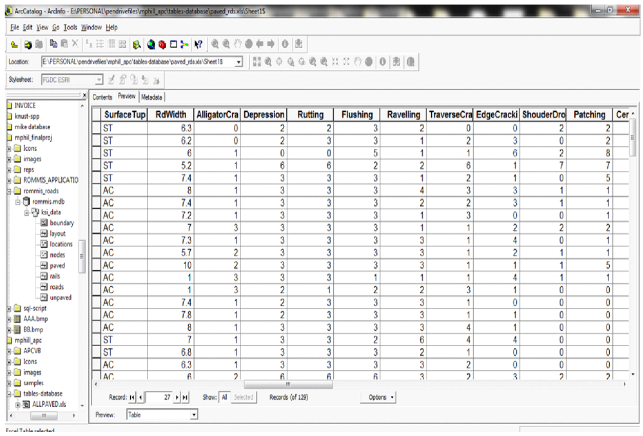
- The application was tested with field values to determine whether the parameters defining the data elements meet the required specifications and also to verify that expected output is produce. Out of the 1978.78 km of inventoried roads of all classes and surface types in Kumasi, a total of 1752.38 km was captured in the road maintenance database and was tested for reliability. Table 2 shows a section of road sectional data in the database of two sections in the city, on the 24th February road and Okomfo Anokye road in the western bypass of the central ring road and the Adukrom link.
|
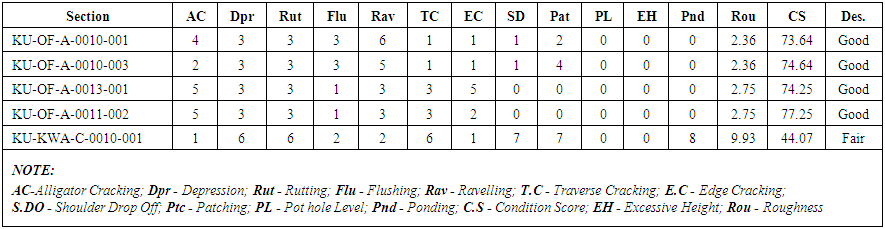 | Table 3. Field Data for Condition Score Calculation |
 | Figure 10. Field Data for Condition Score Calculation in GIS |
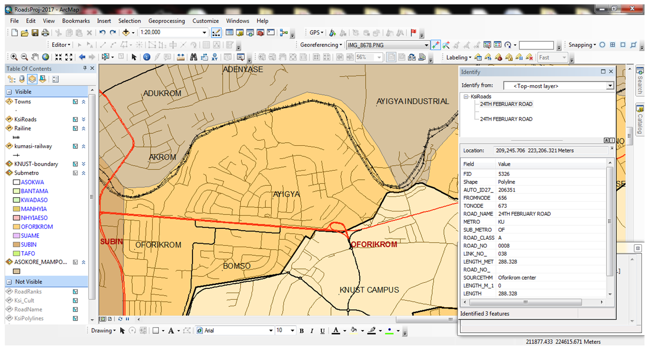 | Figure 11. Identify results of a section on 24th February road |
|
|
|
|
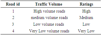
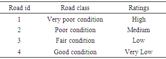
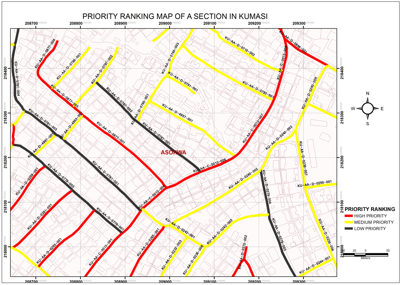 | Figure 12. Priority ranking of pavement |
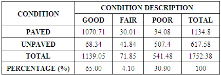
7. Conclusions
- The results and the analysis discussed clearly shows that the GIS based application is reliable, precise and can be used for an effective monitoring and evaluation of the road network. There are 1975.78 Km of roads of all classes in Kumasi metropolis, but a total of 1752.38Km were captured in the application database. It was realised from the results that there are 65.00% of roads in good condition, 4.10% of roads in fair condition and 30.90% of roads in poor condition. It also shows that out of the total network of 1752.38km captured in the database, 1134.8km were paved and 617.58km were unpaved roads. The system is user friendly, cheap and one need not to be a database expert or an expert in GIS before he/she can operate it. If implemented, it will help decision-makers in taking decisions interactively with the aid of visualisation of data in GIS without requiring any specialised technical skills.