Isaac K. Gitau, Charles N. Mundia
Institute of Geomatics, GIS and Remote Sensing, Dedan Kimathi University of Technology, Nyeri, Kenya
Correspondence to: Isaac K. Gitau, Institute of Geomatics, GIS and Remote Sensing, Dedan Kimathi University of Technology, Nyeri, Kenya.
| Email: |  |
Copyright © 2017 Scientific & Academic Publishing. All Rights Reserved.
This work is licensed under the Creative Commons Attribution International License (CC BY).
http://creativecommons.org/licenses/by/4.0/

Abstract
The choice of a route location is a detailed activity that involves evaluation of different factors in order to attain optimal location. Roads are major projects and therefore need to be located to ensure seamless connectivity, which should be optimal. The objective of this research study was to perform spatial modeling using GIS analysis and weighting criterions using Analytical Hierarchical Process to make site selection for an optimum road. To attain optimal road route location, satellite image of the study area was acquired and the image processed and reclassified to obtain baseline data of the area including the land use land cover map. A Geodatabase was created to allow integration with GIS analysis. GIS database included Shapefiles of soils, existing roads, towns, rivers, and vegetation, noise and dust surveys. Questionnaires administered to various experts were processed to give weights derived using Analytical Hierarchical Process (AHP). The weights from different criterions gave unique normalized Eigen vectors in each category. The weights were applied in the development of a model to obtain an optimum route. From the findings factors that were given high considerations were topographical and physical features, which included slope, vegetation and existing rivers. This was followed by infrastructure, environment and lastly soils according to the weights derived. Two routes from the analysis were realized which were optimal and differed from the original route proposed for the project. The implications of these findings therefore showed that embracement of GIS with integration of different sources of data and remote sensing and analysis using AHP technique should be adopted as a tool and system for a project of similar approach in Kenya.
Keywords:
AHP, GIS, Modeling, Optimal route location
Cite this paper: Isaac K. Gitau, Charles N. Mundia, GIS Modeling for an Optimal Road Route Location: Case Study of Moiben-Kapcherop-Kitale Road, American Journal of Geographic Information System, Vol. 6 No. 1, 2017, pp. 26-39. doi: 10.5923/j.ajgis.20170601.03.
1. Introduction
Road transport in Kenya constitutes a key component of Kenya’s service sector in both their contribution to the country’s employment and income generation and their role in external trade. The Kenya vision 2030 aspires for a country with integrated roads. The Kenya economy is dependent on road transport. Roads constitutes a major transportation channel widely used for carrying goods, passengers and other services (Minna et al, 2015). Roads have been significant contributors to national wealth and are vital elements of the social fabric in many nations because they represent a significant component of national infrastructure capital ( Dixon et al., 2010), therefore there is significant need for these roads to be optimal and reduce costing during construction and at the same time using modern methods to perform routing like GIS and remote sensing techniques. There is need to avoid adverse impacts and to ensure long-term benefits leading to the concept of sustainable development. According to (João & Fonseca, 1996) geographic information systems have the ability to store, integrate, analyze and display spatial attributes of social economic and environmental assessments. GIS can also provide a good function of information technology based on its strong ability on processing spatial data and attribute data. GIS has enabled the use of sets of simple operations such as overlay, classification, interpolation, aggregation of spatial information (Antunes et al., 2001) Evaluation of optimum route is a complex activity since there is need to be a balancing of various factors to come up with optimum route. GIS functionalities are useful in integrating various datasets, performing analysis and modeling for optimum route location. These functionalities address various hurdles of getting an optimized route basing on the various criteria.Roads in Kenya are under the umbrella of Kenya Roads Board, which its major task is to oversee the road network in Kenya and coordinate the development, rehabilitation and maintaining of these roads. Improved roads have attracted many investors along the road corridors (Gichaga, 2016).Traditional routing of roads in the earlier times involved use of bulk paper work, and use of baseline information that was not so precise and conclusive. In most cases, these baseline data lacked precise information on land cover, vegetation pattern, geomorphology, hydrogeology, drainage pattern, air, water, and noise quality, socio-economics, etc.The adoption of advanced technologies like remote sensing and GIS provides accurate and synoptic spatial and temporal databases on vegetation and land cover, surface hydrology, and aerosols for larger areas in a time- and cost effective way. Remotely sensed data is collected using passive or active remote-sensing system. However, satellite imageries integrated with other data sets are more accurate in delineating land use/land cover. Remote sensed data integrated with GIS has been applied as a tool in detecting land use and land cover (Weng, 2002). Decision-making are based on numerous data concerning the problem of selection appropriate site. Decisions about location involve the evaluation of multiple criteria according to several objectives. While many decisions are made, many are prompted by a single objective hence it also happens that there is need to make decisions that satisfy several objectives where these objectives may be complementary or conflicting (Rikalovic et al., 2014). Analytical Hierarchical Process is a method to derive ratio scales from paired comparisons. It is also a method that allows some small incosistentecy in judgment because human is not always consistent. The ratio scales are derived from the principal Eigen value. AHP decomposes the problem into a hierarchy of sub problems, which can more easily be comprehended and subjectively evaluated. The subjective evaluations are converted into numerical values and processed to rank each alternative on a numerical scale (Saaty, 2008).This paper presents a method that combines remote sensing, GIS and AHP to create a model that analyses criteria to identify an optimum road route and Eigen vectors that gave weights to the criterions.
2. Methodology
Methodology adapted for this study had two categories of data: GIS data and remote sensing data. A Geodatabase was created in ArcGIS 10.3 where it housed all the data and parameters used in this research. All data was logically and consistently checked for errors, additions, emissions or gaps. For Remote sensing data, Aster satellite image was used and preprocessed using ERDAS 10.0 software. The GIS data was prepared in the Geodatabase giving rise to the various categories of soils, air quality, noise levels, slope, existing roads, existing rivers and towns. Weights were derived for the road using Analytical Hierarchical Process and modeling the road route using them. A new model was developed that incorporated all the variables stored in the Geodatabase giving in to an optimum route or location for the road.
2.1. Study Area
the road measures approximately 80km and starts at the junction of Eldoret – Legebet road near Moiben and proceeds in a northerly direction to Cheborwa, where it turns westwards to Kapcherop, Kipkeikei, Sibanga where it continuous in westerly direction to Kitale. The road traverses through three counties in Kenya namely UasinGishu, ElgeyoMarakwet and TransNzoia.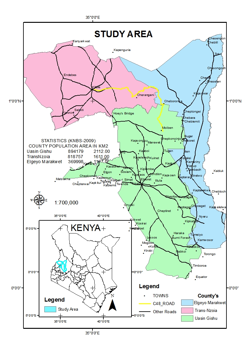 | Figure 1. Study Area |
2.2. Datasets and Materials
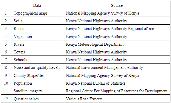
For this research, activities involved the integration of primary and secondary data sources, databases and satellite images. GIS datasets used were soils, roads, vegetation, rivers, towns, noise levels, air quality levels, county, schools and settlements data. Other additional data were existing topographical maps of the area. Spatial data also included expert questionnaires that were later analyzed to give weights to various criterions. Table 1. Datasets used for modeling for optimal route
 |
| |
|
2.3. Research Framework
The research framework adopted for this study is summarized in Figure 2. The methodology involved the selection of Spatial and non-spatial factors that would affect the routing of the road. Spatial data used was topographical sheets obtained from national mapping agency Survey of Kenya. Expert questionnaire also formed spatial data. A geodatabase was created in ArcGIS 10.3 where it housed all the data and parameters for this research. Aster satellite image was used and pre-processed using ERDAS 10.0 software. Sub setting was done to the mosaicked image and later linked to Google Earth view. Image classification was done using maximum likelihood to extract quantitative information from the image. From the various factors and criteria set of rules were established to minimize the road from crossing rivers, schools, settled areas, wetlands and flood prone areas. Rules to minimize the disruption of sound produced by the heavy machinery and dust emitted from the construction sites, rules to maximize the connectivity with other roads. For suitability process to be achieved, the data was converted in raster format and reclassification followed. When reclassification was done each cell was given a value which would tally from the rules set to obtain a suitable and optimum route. Derivation of weights for the road was done using Analytical Hierarchical Process and modeling the road route using them. Multi Criteria Decision Making (MCDM) is a procedure which transforms and combines geographical data and value judgments to evaluate a set of alternatives with respect to relevant criteria (Malczewski, 1999). This method combines all-important spatial criteria and illustrates the most suitable location for a certain land use on a map. GIS-based multi-criteria decision analysis provides flexibility that may be used for analysis, comprehension and reevaluation of a decision problem (Malczewski, 1999).Upon completion of AHP, the weights relative to each other factor were obtained through an iterative procedure by obtaining the Eigen vectors of the pairwise Comparison Matrix. The weights were adopted for weighted overlay procedure to get the suitability map. It was prudent to reclassify all the input factors in such a way that they can be compared one to one. The variables were compared as per Saatys’ scale (Saaty, 2003). The study developed a suitable model for the road, it was done in a way that a criteria was loaded in the Geodatabase with its weighted influence and when validated gave a suitable site. This procedure was done for all the datasets to achieve an overall of a final weight of the model that gave the best route.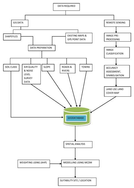 | Figure 2. Research methodology |
3. Results and Analysis
The results for the land cover mapping are presented in Figure 3. The results show the land cover derived from supervised classification. The land cover classes included: forest land, cropland & pasture, agricultural land, built-up/urban and rangeland.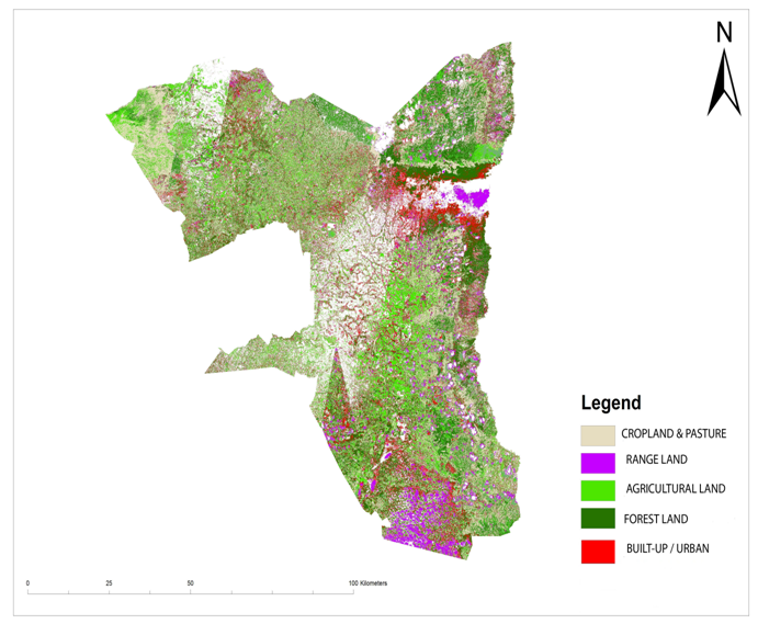 | Figure 3. Classified image of the Area of Study |
Results for soil analysis are presented in Figure 4. The results show the soil classes of the area and the original route. The area is generally covered with clayey soils taking more preference followed by loamy, very clayey and sand soil the least.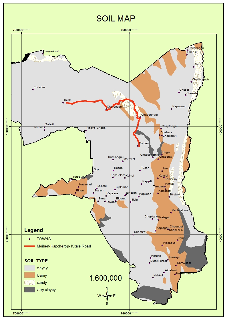 | Figure 4. Soil Map of the study area |
Results for drainage description are presented in Figure 5. The results show that there were four major types of drainage pattern of this area. The original route traversed from moderately well drainage, through a well-drained and ends onto a poorly drained area.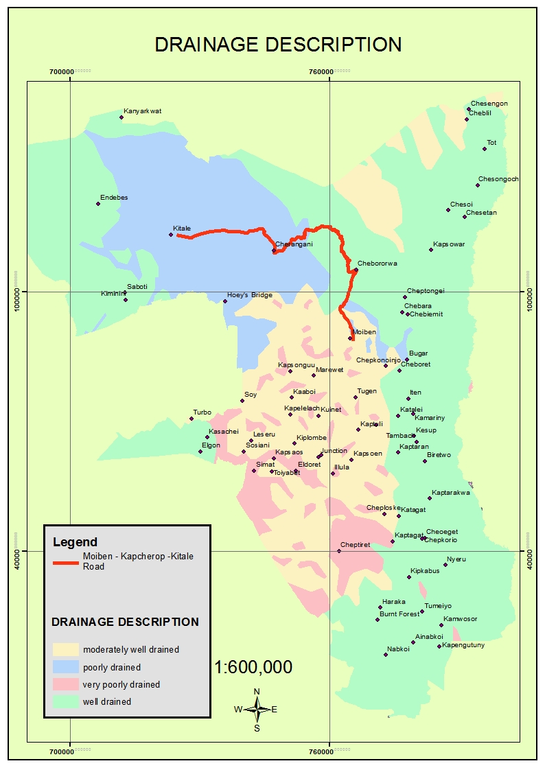 | Figure 5. Drainage Description |
Results for slope analysis are presented in Figure 6. The results show the graduation in dark brown representing the steepest places. This is the mountainous places of the area. The original route showed that it traversed on a gently undulating surface.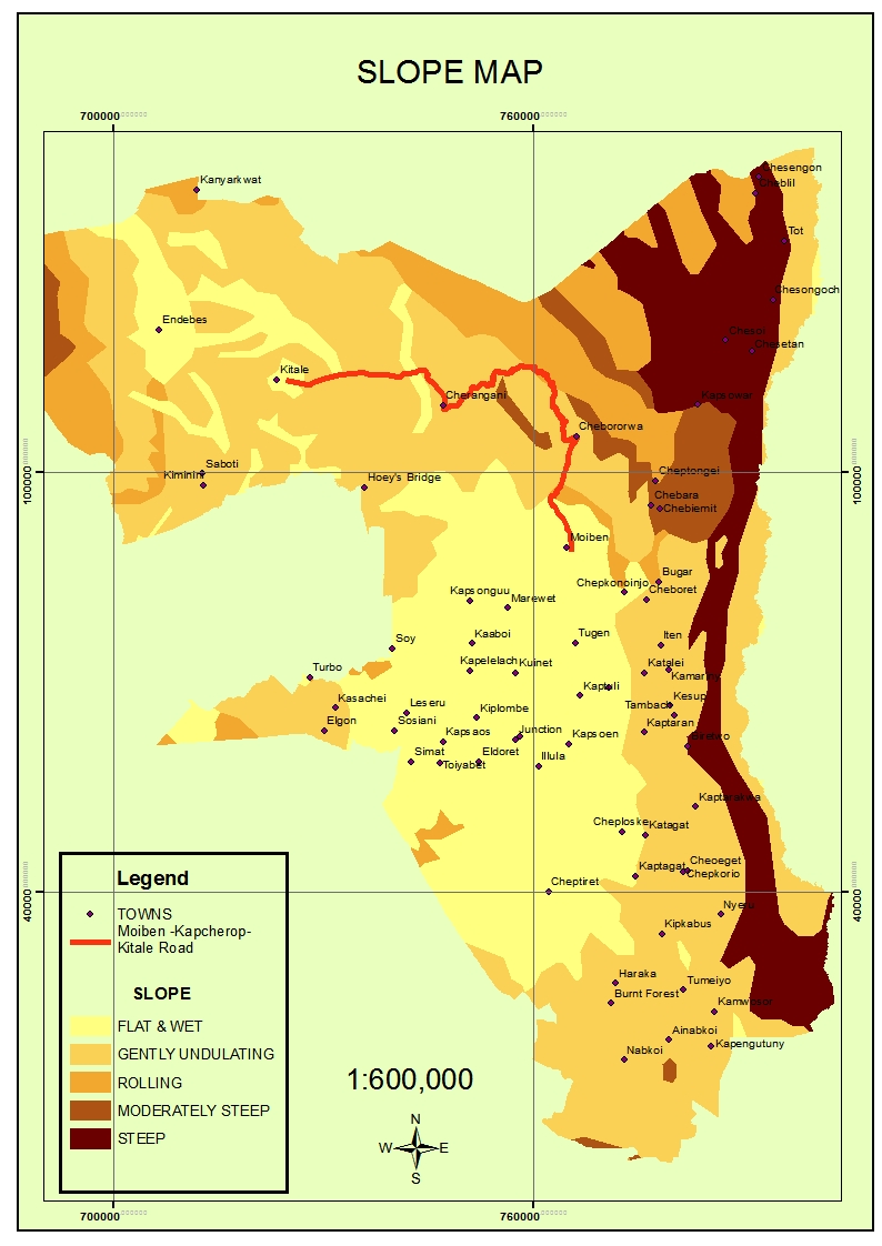 | Figure 6. Slope Map |
Results for river pattern are presented in Figure 7. The results show that the area is widely covered by a pattern of many rivers. These can be attributed by been an area that’s hosts some forests and have two rainy seasons with rainfall ranging between 900mm to 1200mm annually. It has a cool and temperate climate, with annual temperatures ranging between 8.4°C and 27°C. There is a need to reduce the cost when constructing such a road by avoiding areas where the road shall cut a river due to the construction of bridges and gabions.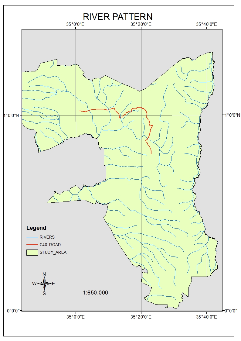 | Figure 7. Map of River Pattern |
Results for roads and towns are presented in Figure 8. The results show that the study area is characterized by several economic activities and industries and therefore there is need for connectivity from one point to another. It has several tourist attractions with scenic beauty, sports tourism, cultural tourism and eco-tourism. The road developed therefore should be of minimum cost and increase connectivity in the area.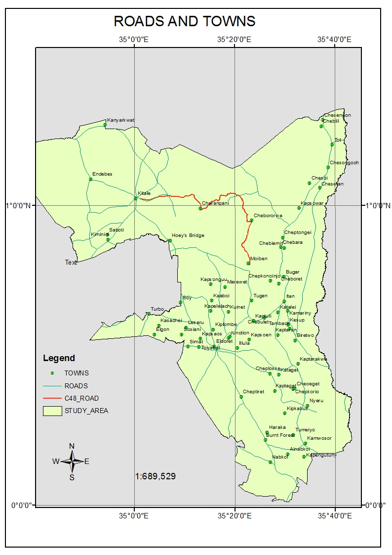 | Figure 8. Map of road network and towns |
Table 2. Land use Land cover statistics
 |
| |
|
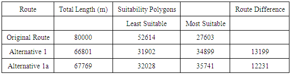
Results for the filtered alternative routes are presented in Figure 9. Based on the overall criterion alternative routes were calculated. The original route was 80,000m. After weighting all the criteria and doing the calculations on the pixels that the original route took, two alternative routes were hence calculated and analyzed as shown by Table 3.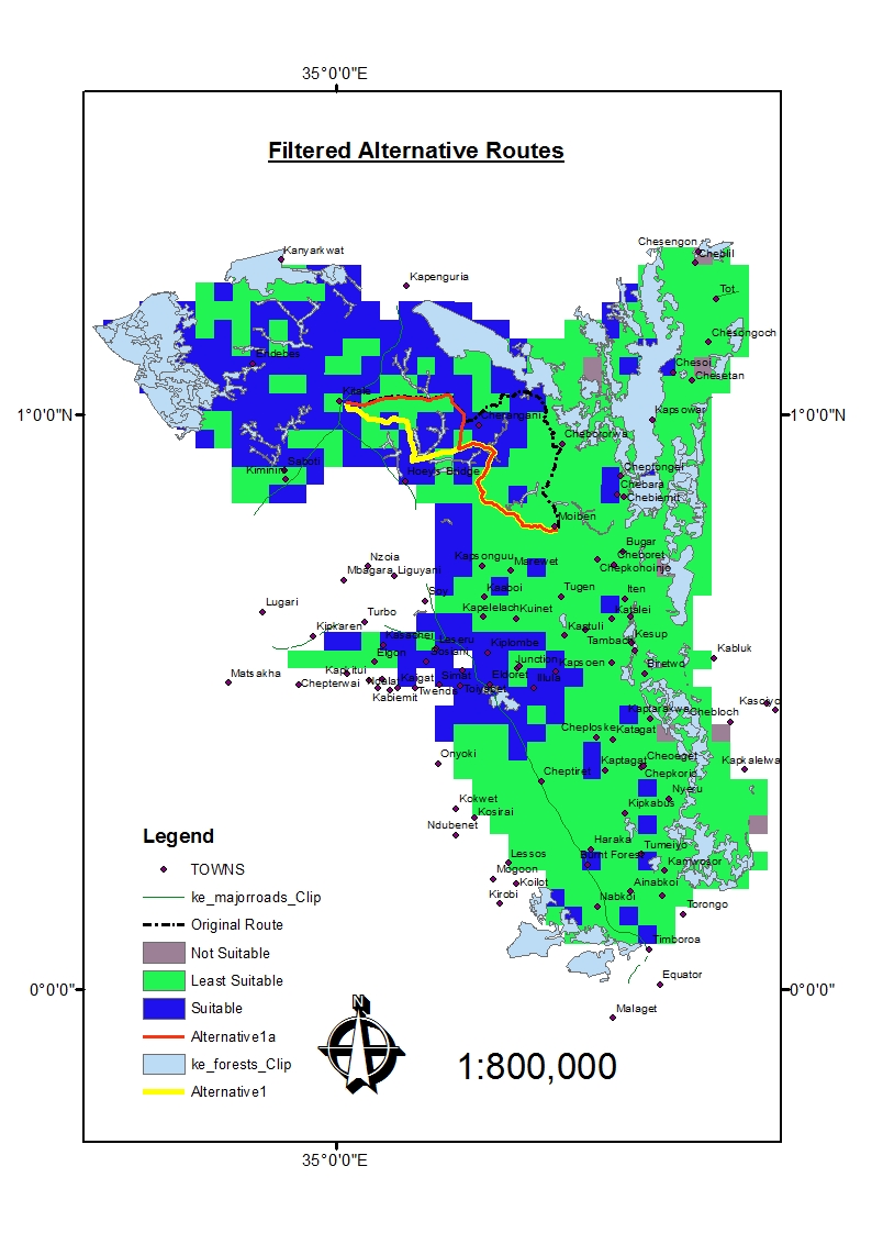 | Figure 9. Filtered alternative Routes |
Table 3. Results for alternative routing
 |
| |
|
Therefore, alternative route 1 was shorter by 13,199m while alternative 1a was shorter by 12,231m. Results for the original elevation profile are presented in Figure 10. The results shows that from the elevation values, this road started at 2126.5176m asl, then it gradually fell to 1958.9407m asl before shooting up to an elevation of 2357.6616m asl. This greatly has shown that some factors of slope and terrain were not given much consideration on its original design. The minimum elevation was 1800.8461m asl and the maximum was 2405.257m asl.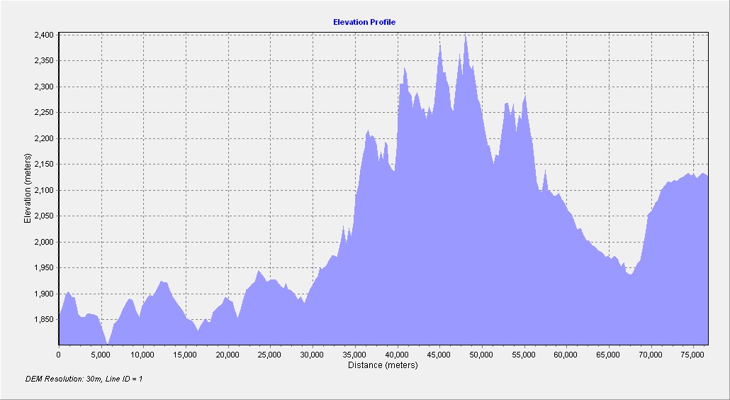 | Figure 10. Elevation Profile for the Original Route |
From the alternative 1a elevation profile, the elevation started 2127.0667m asl and smoothly fell to 1948.7696m asl at a distance of 35km.This has shown from the criterion of topography and physical features, these factors if considered in the design and construction would give an optimum road. The lowest elevation was 1802.4237m asl and highest was 2128.5815m asl, this shows that there was an incredible drop of the highest elevation with a 276.6755m asl difference. Such an elevation in terms of quantities for design of a road is a huge saving on material cost when implemented.For the elevation profile for alternative 1 route, the starting nodes coincided with that of alternative route 1a up to a distance of 35km where there was change of elevation. This route had the lowest elevation of 1794.6304m asl and a highest with 2129.4272m asl. Statistically, and graphically this route demonstrated to be the optimum route. The study developed a new suitable model for the road, it was done in a way that a criteria is loaded in the Geodatabase with its weighted influence and when validated gives a suitable site. An extract of the model Figure 11 shows the blue shaded ovals as inputs as e.g. towns is converted to Euclidean distances and extracted by Mask of the study area. It is then reclassified and a weighted overlay of towns achieved under infrastructure leading to an overall of a final weight of the model that gives the best route.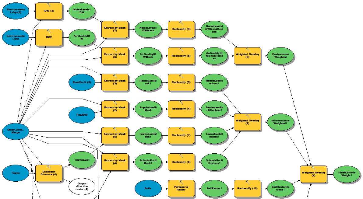 | Figure 11. Part of the Model |
4. Conclusions
This research objective was to perform spatial modeling using GIS analysis and weighting criterions using Analytical Hierarchical Process to come up with suitable sites for an optimum road. GIS and Remote sensing techniques were integrated in this study. Questionnaires administered to various experts were processed to give weights derived using Analytical Hierarchical Process (AHP). The weights from different criterions gave unique normalized Eigen vectors in each category. The weights were then applied in the development of a model to obtain an optimum route. Eight factors that were considered were slope, existing roads, rivers, air quality, towns, vegetation settlement and schools. Analytical Hierarchical process was used as a way to get relative preference of every factor used in this study.Information from experts was arranged in a hierarchical tree and using pairwise comparison relative criterion over another was expressed. Topographical and physical factors gained the highest choice. This was followed by infrastructures, Environments and Soils. From the results on topographical and physical factors, conclusion was drawn that there is much need to conserve the environment by avoiding diverging of rivers, avoiding vegetation clearing and avoiding so much of excavation of the land. Under the category of soils, this study has shown that much of this land was suitable for this road however only a small percentage gave the most suitable site. From the category of Infrastructures, more priority was given to settlements. This implies that for an optimum route to be achieved people can pave way for the road and this has shown that the roads proximity is near the people. This study has presented the results of an integrated GIS data sources with remote sensing data for a road project. In addition, the research has combined the use of AHP mode of decision making with GIS as an approach to factors that can be addressed for similar road projects in the country Kenya. Elevation profiles that were generated from this route clearly demonstrated that there was a huge change in elevation of this route. This results show the importance of conservation of vegetation, rivers and choice of fair slope for the route. The Model generated in this study was dynamic and other factors that were not considered can be incorporated to achieve results that are more precise. It is recommended that GIS, Remote sensing and AHP techniques can be adopted for obtaining optimum route for a road or any other linear project in Kenya. Policy and decision makers therefore need to welcome the role of using GIS and AHP as a method, which can be used for decision-making. To improve the results obtained from this study, it is recommended that more research need to be carried out whereby more datasets should be incorporated in the final model to give the final criteria.
References
| [1] | Antunes, P., Santos, R., Jordão, L., João, E., Fonseca, A., Sahzabi, H. Y., Vorovencii, I. (2001). The application of Geographical Information Systems to determine environmental impact significance. Environmental Impact Assessment Review, 21(6), 511–535. http://doi.org/10.1016/S0195-9255(01)00090-7. |
| [2] | Gichaga, F. J. (2016). The impact of road improvements on road safety and related characteristics. IATSSR, 0–3. http://doi.org/10.1016/j.iatssr.2016.05.002. |
| [3] | João, E., & Fonseca, A. (1996). The Role of Gis in Improving Environmental Assessment Effectiveness: Theory Vs. Practice. Impact Assessment, 14(4), 371–387. http://doi.org/10.1080/07349165.1996.9725913. |
| [4] | Malczewski, J. (1999). GIS and Multicriteria Decision Analysis. Geographical Analysis, 34(1), 91–92. http://doi.org/10.1353/geo.2002.0003. |
| [5] | Paper, C., Minna, T., Minna, T., & Minna, T. (2015). Application of GIS as Support Tool for Pavement Maintenance Strategy Selection, (JUNE), 0–13. |
| [6] | Rawat, J. S., Biswas, V., Kumar, M., Schaller, J., Wallace, J., Dell’Acqua Fabio, … Ogola, P. F. A. (2002). Gis Application in Environmental Planning. International Conference On Land Policy Reform, 16(2), 1–32. http://doi.org/10.14429/dsj.61.421. |
| [7] | Rikalovic, A., Cosic, I., & Lazarevic, D. (2014). GIS based multi-criteria analysis for industrial site selection. Procedia Engineering, 69, 1054–1063.http://doi.org/10.1016/j.proeng.2014.03.090. |
| [8] | Saaty, T. L. (2003). Decision making with the AHP, Why is the principal eigenvector necessary. European Journal of Operational Research, 145, 85–91. |
| [9] | Saaty, T. L. (2008). Decision making with the analytic hierarchy process. International Journal Services Sciences, 1(1), 83-98. |
| [10] | Weng, Q. (2002). Land use change analysis in the Zhujiang Delta of China using satellite remote sensing, GIS and stochastic modelling, 273–284. http://doi.org/10.1006/jema.2001.0509. |
| [11] | Willmott Dixon, Thorpe, D., Enshassi, A., Mohamed, S., Abushaban, S., & Cours, S. (2010). The Impacts of Construction and the Built Environment. Journal of Civil Engineering and Management, 1(800), 269–280. http://doi.org/10.3846/1392-3730.2009.15.269-280. |

 Abstract
 Reference
 Full-Text PDF
 Full-text HTML