-
Paper Information
- Paper Submission
-
Journal Information
- About This Journal
- Editorial Board
- Current Issue
- Archive
- Author Guidelines
- Contact Us
American Journal of Geographic Information System
p-ISSN: 2163-1131 e-ISSN: 2163-114X
2017; 6(1): 1-13
doi:10.5923/j.ajgis.20170601.01

Multi Criteria Evaluation Approach Based on Remote Sensing and GIS for Identification of Suitable Areas to the Implantation of Retention Basins and Artificial Lakes in Senegal
Diouf R.1, Ndiaye M. L.2, Traore V. B.3, Sambou H.1, 2, Giovani M.4, Lo Y.5, Sambou B.1, Diaw A. T.2, Beye A. C.3, 4
1Institute of Environmental Sciences, Cheikh Anta Diop University, Dakar, Senegal
2Geoinformation Laboratory, Polytechnic High School, Cheikh Anta Diop University, Dakar, Senegal
3Hydraulics Laboratory and Fluid Mechanics, Cheikh Anta Diop University, Dakar, Senegal
4Laboratory of Physics of Solids and Sciences of Materials, Cheikh Anta Diop University, Dakar, Senegal
5Direction of Retention Basins and Artificial Lakes, Dakar, Senegal
Correspondence to: Diouf R., Institute of Environmental Sciences, Cheikh Anta Diop University, Dakar, Senegal.
| Email: |  |
Copyright © 2017 Scientific & Academic Publishing. All Rights Reserved.
This work is licensed under the Creative Commons Attribution International License (CC BY).
http://creativecommons.org/licenses/by/4.0/

This paper aims to provide basic information relative to identification of sites suitable to the realization of retention basins and artificial lakes in Senegal to store productive water. For this, an approach based on several criteria and combining remote sensing and GIS, has been implemented. The data used first underwent a preprocessing consisting of harmonizing the layers by georeferencing, projection and conversion into raster. Fourteen criteria layers including Land use, Elevation, slope, Hydrogeology, Pedology, Locality and Drainage Density, Watershed average slope and elevation, Rainfall, Distance from the road, Gravelus index, Ecogeographic areas and Population density were then defined to identify all sites suitable for realization of retention basins and artificial lakes. ArcGIS 10.1 software through its extension Weighted sum overlay was used to aggregate layers. The results obtained, allowed prioritizing the sites in four classes: very high suitability, high suitability, moderate suitability and low suitability. In fact, 21.11% of the total areas of Senegal are very highly suitable to the planning of these structures. Validation of the results gave an accuracy of 0.81. This study represents a considerable asset for decision-makers in the search for strategies for management and planning of water resources for the intensification of sustainable and profitable agriculture to ensure food safety.
Keywords: GIS, Remote Sensing, MCE, Suitability Analysis, Food Security, Sustainable Development, Senegal
Cite this paper: Diouf R., Ndiaye M. L., Traore V. B., Sambou H., Giovani M., Lo Y., Sambou B., Diaw A. T., Beye A. C., Multi Criteria Evaluation Approach Based on Remote Sensing and GIS for Identification of Suitable Areas to the Implantation of Retention Basins and Artificial Lakes in Senegal, American Journal of Geographic Information System, Vol. 6 No. 1, 2017, pp. 1-13. doi: 10.5923/j.ajgis.20170601.01.
Article Outline
1. Introduction
- Scientific evidence indicates that due to increased concentration of greenhouse gases in the atmosphere, the climate of the Earth is changing; temperature is increasing and the amount and distribution of rainfall is being altered [1]. [2] reveals that these changes have multiple consequences difficult to pin down. One of the major consequences of climate change is undoubtedly the reduction in the availability of sufficient water resources for the improvement of food security [3-5]. Given climate variability and the sometimes dramatic consequences, the evolution of water resources is a concern at worldwide [6]. Africa is the continent most vulnerable to the effects of climate change [4, 7]. Its important economic sectors such as agriculture, livestock, etc., are vulnerable to the current sensitivity of climate with enormous economic impacts. 70% of the African population lives on agriculture even if half of the cultivated African territory is considered as arid or semi-arid [8-10]. According to [11] in the medium term, 600000 km2 of agricultural land classified as moderately handicapped by water lack, will pass to the level of severely mortgaged by shortages. This contributes according to [12], to further weaken Africa's adaptive capacity thereby increasing the continent's vulnerability to projected climate change.Sudano-Sahelian countries have for some thirty years, persistent drought [13, 14]. In Senegal, climate variability is mainly characterized by a significant reduction in rainfall leading to the reduction and degradation of water and natural resources [15-17]. These climatic constraints accelerated by anthropic actions, with population growth, urbanization, extension of cultivated areas and clearing, deforestation and overgrazing, led to degradation of vegetation cover, soil degradation, fall of agricultural, forestry and pastoral production, in general to the decline of the rural economy [18]. This water deficit did not spare the Senegalese agricultural sector with the degradation of the agro-sylvo-pastoral ecosystems generating a decrease in yields, the fall of incomes exposing the rural populations to precariousness and food insecurity [19, 20]. Agriculture is considered in Senegal as the main economic activity in rural areas employing about 70% of the active population [21]. [22] thinks that the best way to combat the impact of climate change on the living conditions of poor population, sectors of economic activity and the environment, is to integrate adaptation measures in development planning. Otherwise, agricultural production deficits would be increased, exposing populations to food insecurity [23]. To this end, numerous initiatives on political, institutional and scientific governance have been undertaken at the global, continental, sub regional and national levels to provide adequate responses to the challenges posed by climate change [24]. Indeed, the control of water seems to be an alternative to remedy the difficulties arising from the meteoric evolution of the agricultural policies. To face the climate riskiness, water control policies have been developed everywhere throughout the world: in Africa, Europe, Asia and America [25]. In Senegal, despite the investment efforts made in the Senegal River basin by SAED, Anambe by SODAGRI and Gambia River basin for the development of large irrigation, the potentially manageable areas remain important. Moreover, local small-scale irrigation, which involves a large part of the small rural family farm by controlling runoff, is very low compared to the existing potential [18]. This also shows that Senegalese agriculture is very dependent on rain. However, thousands of m³ of water are lost each year by runoff towards the sea, due to lack of storage structures, while water is a limiting factor for our agriculture [18]. It is in this sense that [26] said every drop of rain that falls, should be used instead of reaching the sea. Therefore, a good control of the water has become indispensable for a sustainable development of the Sahelian zone. In the perspective to effectively controlling runoff for the development of productive and sustainable agriculture, the authorities of Senegal initiated in 2000 a major project for the mobilization and exploitation of runoff water called "National Program of Retention Basin and Artificial Lakes". The primary objective of this program is to collect and store runoff water. This can strengthen water availability, improve people's living conditions, restore ecosystems, diversify production and combat rural exodus. Secondly, it aims to recharge groundwater, protect bridges, roads and fight against water erosion and flooding. In the framework of this retention basin policy, approximately 220 sites were developed between 2000 and 2009 on a total of 3240 planned. Storm water retention structures are also a development alternative for effectively achieving the Sustainable Development Goals (SDG). Thus, their valorization through efficient management could become centers for the development of wealth-generating activities (market gardening, mixed-use gardens, off-season crops, silviculture, fish farming, watering troughs), especially for vulnerable groups, especially young people and women [27]. The retention basins contribute to the improvement of the living conditions thanks to and fight poverty through self-consumption [28-32]. They supply the surrounding and urban markets with vegetables and dairy products, thus strengthening the dynamic city-countryside [32]. [33] add that the optimal exploitation of hilly lakes, is at the origin of the creation of a significant annual income supplement that translates into improved habitat and land speculation Land adjacent to the lakes. And according to [34], these hydraulic installations have become a true "natural heritage" that needs to be better known today to secure both resources and forms of exploitation. Consequently, these infrastructures contribute to local development, which generates strong demand at the national level [32], hence the need to identify other potential sites across the country. Established in fragile environments with low economic activities, these small dams are perceived as an additional, vital but uncertain resource. The choice of settlement sites and the management of reservoirs must be linked to precise conservation objectives or deliberately geared towards rural development [33]. This study aims to contribute to the identification of potential areas for the management of retention basins and artificial lakes using decision-making tools. Indeed, decision making is a sequence of activities that starts with identifying a problem and ends with recommendations for a decision [35]. Land-use suitability analysis is a multicriteria evaluation, which aims at identifying the most appropriate spatial pattern for future land uses according to specify requirements, preferences, or predictors of some activity [36-38]. According to [39], land suitability analysis has to be carried out in such a way that local needs and conditions are reflected well in the final decisions. GIS and Remote Sensing based Multi Criteria Evaluation (MCE) is a method of analyzing land suitability evaluation [40-43]. It may be used to develop and evaluate alternative plans that may facilitate compromise among interested parties [44]. Central to GIS and MEA is the aggregation algorithms or decision rules [45]. In this study, we used the WLC algorithm [55]. Indeed, the Weighted linear combinaison model is one the most widely used GIS-based decision rules [45-47]. The method is often applied in land use/suitability analysis, site selection, and resource evaluation problems [48-51]. It involves standardization of the suitability maps, assigning the weights of relative importance to the suitability’s maps, and then combining the weights and standardized suitability maps to obtain an overall suitability score [40]. In this study, mapping of the land suitable to the development of retention basins and artificial lakes is approached following a multicriteria approach, integrating several sources of information of topographical, climatic, hydrological, pedagogical, socio-economic and environmental order. Until then, traditional methods are used to locate the sites favorable in Senegal [18]. The results from these classical methods are not totally reliable and scientifically rigorous. That is why, it is judicious to use decision-making tools that have demonstrated their relevance in similar studies. The advantage of this method is to create a database and facilitate the identification of potential sites. Many other applications such as construction of hydraulic structures, installation of road infrastructures, flood control, etc., are rapidly possible. This paper is organized as follows. The study area and data are presented in Section 2. The methodology used is presented in Section 3. The results are presented in Section 4. Finally, Section 4 gives conclusions regarding the capabilities of MCE approach and findings.
2. Materials and Methods
2.1. Study Areas and Data
- Senegal is located in the extreme west of Africa between latitude 12° 8 and 16° 41 north and longitude 11° 21 and 17° 32 west. It covers an area of 196 712 km2 and its population is estimated to 12 171 265 [51]. It is limited to the North by Mauritania, east by Mali, South by Guinea Bissau and Guinea Conakry and East by the Atlantic Ocean (Figure 1). Administratively, Senegal is divided into 14 regions, 45 departments, 46 districts, 113 municipalities, 370 rural communities and 14,958 villages. There are 54 cities in Senegal with more than 10,000 inhabitants. It is a fairly flat country with an average altitude less than 50 m [52]. Its vegetation is dependent on rainfall distribution, following north-south gradient. Three major phytogeographic areas stand out: the Sahelian, Sudanian and Guinean domains. The climate of Senegal is characterized by high rainfall variability from one year to another, more formidable variability than the annual average is lower; plus annual total is shrinking, more rains are uncertain and irregular. Thus in the south, the average of 1250 mm (Ziguinchor raingauge), results from rainfall ranging from 900 mm to 1 400 mm, in the north, the average of 414 mm (Linguere raingauge), covers rainfall ranging from 850 mm in exceptionally rainy year to 200 mm in dry years [53-55]. Temperatures are generally high. The minima are reached during the dry season (15-20°C) and the maximum during the rainy season (35-40°C). Senegal is watered by very important rivers such as: Senegal River long of 1770 km, (with 337,000 km2); Gambia River long of 1150 km (77,000 km2); Casamance River 200 km long (21,150 km2) and other secondary watercourses such as Saloum, Lac de Guiers, Anambe and Kayanga. The water system consists essentially of non-perennial flowing rivers with the exception of Senegal and Gambia rivers in their upstream basin. In this context, the control and rational management of water resources requires a better knowledge of these temporary flows [56]. Most of Senegal's economy comes from the primary sector where 54% of the working population lives on agriculture, which contributes 7.86% of the Gross Domestic Product (GDP).
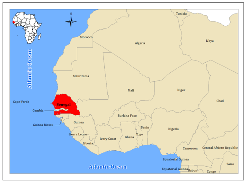 | Figure 1. Location of the study area |
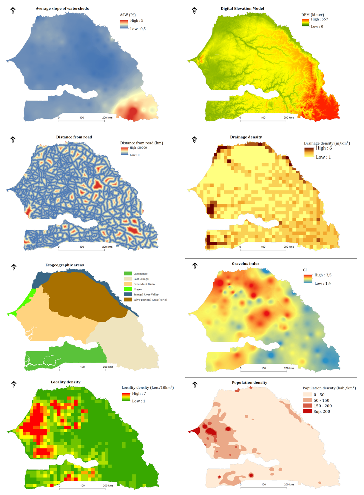 | Figure 2a. Presentation of Remote Sensing and GIS Data |
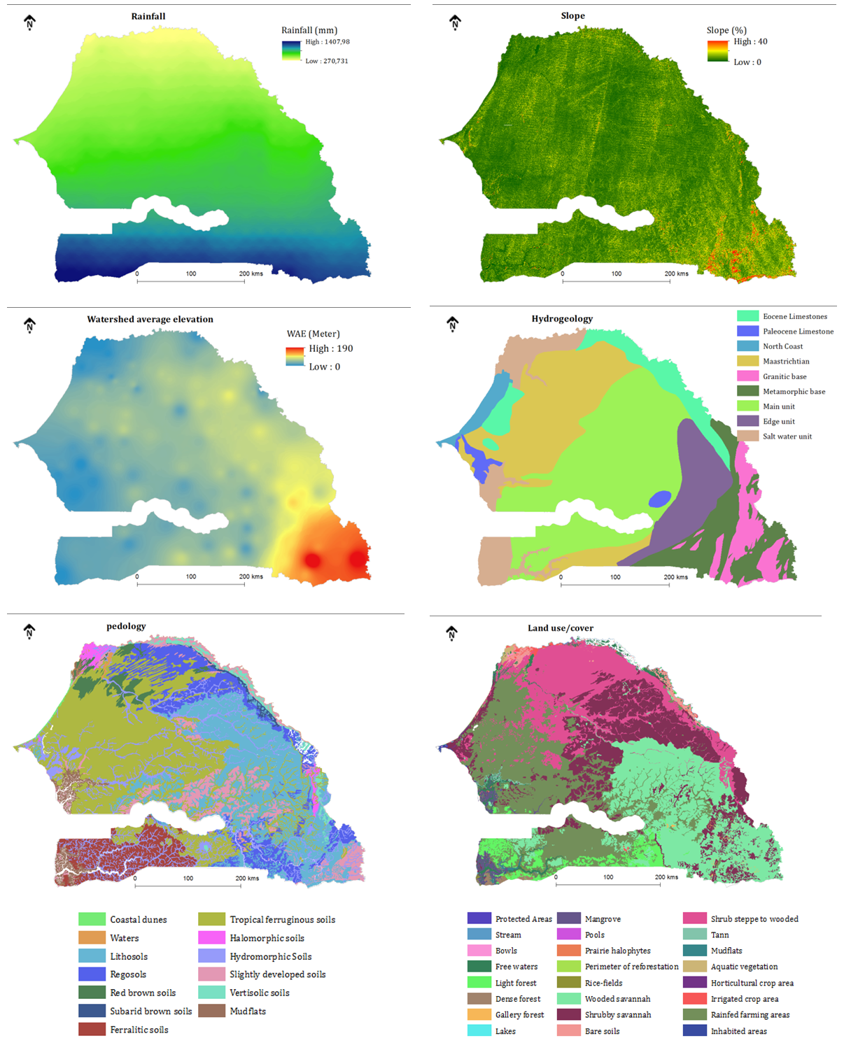 | Figure 2b. Presentation of Remote Sensing and GIS Data |
2.2. Methods
2.2.1. Data Processing
- The data used in this study, are of different sources and natures. Their descriptions, formats and sources are summarized in Table 1. However, they require a pretreatment step before their use in the modeling phase. The SRTM digital terrain model is used to extract the altitude and slope of the study area. It was also used to extract the watersheds and the reaches of the area and thus determine their altitude and average slope. A TRMM image on the rainfall was first georefected and then oriented by rotation of 90°. The study area is extracted from the image and then converted to ASCI format to extract the rainfall data. The raster datasets are then generated using Inverse Distance Weighted (IDW) spatial interpolation tool in ArcGIS 10.1 platforms. All data used in this study, are converted into raster with a resolution of 100m, and they were initially georeferenced and projected into the system WGS 1984 UTM Zone 28 N. The following criteria are obtained in this study: Land use, Elevation, slope, Hydrogeology, Pedology, Density of locality, Density of drainage, Watershed average slope and elevation, Rainfall, Distance from the road, Gravelus index, Ecogeographic Areas and Population density.
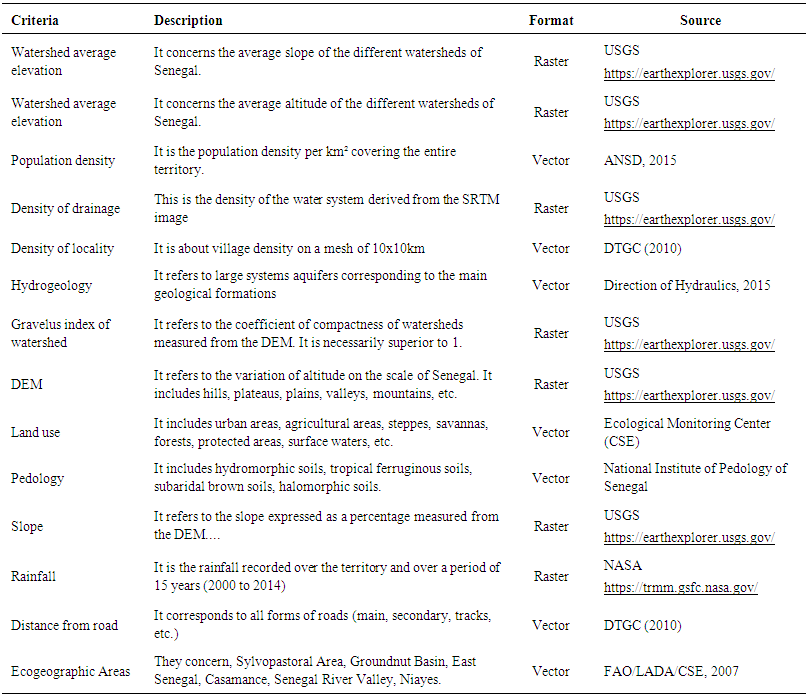 | Table 1. The geoinformation data used and their descript ion in this study |
2.2.2. Criterion Weighting
- The criteria don’t have the same effect on the choice of site. Therefore weights will be assigned to each according to their order of importance. The specialists, who have provided the criteria weights, are professionals and researchers from state structures, such as the Direction of Retention basins and Artificial Lakes (DBRLA) and the Direction of Water Resources Management and Planning (DGPRE). If the number of criteria is high, it is often difficult to estimate the relative weight of each [58-60]. In this study, we used a simple approach to weigh the 14 criteria. It consists for each evaluator to assign a weight to the different criteria on a scale of 0 to 1 or from 0 to 100. The scores can be in whole or in decimal, according to the score scale used. And the sum of the scores of each evaluator must be equal to 1 or 100. Therefore, to obtain the final score for each criterion, which will be used in the aggregation step, we can proceed in two ways: 1) calculation of the average of the scores assigned by the evaluators for each criterion considered individually and 2) to calculate the ratio between the sum of the scores of a given criterion and the sum of the scores of all the criteria. In both cases, the sum of the scores or weights is equal to 1 or 100. Table 2 shows the method of obtaining the final weights.
 | Table 2. Process of obtaining the final weights of the different criteria |
2.2.3. WLC (Weighted Linear Combination)
- The Weighted Linear Combinaison (WLC) technique is a decision rule for deriving composite map using GIS. It is one of the most often used decision model in GIS [61]. Weighted Linear Combinaison, or simple additive weighting, is based on the concept of a weighted average in which continuous criteria are standardized to a common numeric range, and then combined by means of a weighted average. This method is based on the weighted average [62]. The method can be executed using any GIS system with overlay capabilities, and allows the evaluation criterion map layers to be combined in order to determine the composite map layer which is output. To apply the WLC analysis practically, ArcGIS 10.1 software through its extension Weighted sum was used. It uses a weighted sum analysis that is act as a WLC analysis. A weighted sum analysis provides the ability to weight and combine multiple inputs to create an integrated analysis. In other words, it combines multiple raster inputs, representing multiple factors, of different weights or relative importance [50]. Each criterion was reclassified and each class was assigned a score on a scale of 1 to 5 indicating the level of vulnerability according to the opinion of the national experts consulted for this purpose (1 = very highly suitable, 2 = highly suitable, 3 = moderately suitable, 4 = lowly suitable and 5 = not suitable). Consequently, there are criteria with different numbers of classes. Scores and weights were assigned to the different criteria. The Layers, the criteria used, their scores, and their weights are summarized in table 3. After assigning factor scores and weights, suitability score was calculated by using the equation:
 Where, S, is the sum of the product of the individual weight, wi, and the score, xi for each factor, i.
 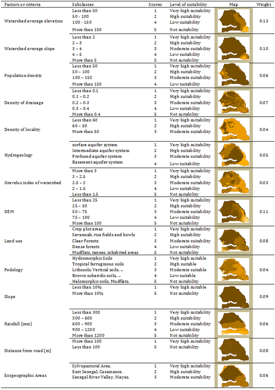 | Table 3. Assignment of Scores and Weights to Different Ability Criteria Selected in this Study |
3. Results and Discussion
- Suitability map for retention basins and artificial lakes planning, identified by weighted sum overlay using Spatial Analyst tools in ArcGIS 10.1, is shown in figure 4. The reading of this figure shows the best sites for the development of retention basins, artificial lakes or hydraulic structures. This decision map is subdivided into four classes of aptitude such as: very high suitability, high suitability, moderate suitability and low suitability. Table 4 shows that approximately 71% of Senegalese territory is highly suitable. Only 21% of the territory is very highly suitable (covering an area of 40634, 14 km2), 7.84% moderately suitable and 0.08% lowly suitable. The very high suitability areas are located mainly in the regions of Thies, Diourbel, Fatick and Kaolack corresponding to central-western part of the country. These areas also cover south-eastern Senegal, in the regions of Kolda, Sedhiou and Ziguinchor. In this part of Senegal, traditionally called Casamance, irrigated agriculture is very developed, with mainly the cultivation of rice. On the fitness map, the Senegal River valley is also concerned through the regions of Matam and Saint-Louis. The Niayes region, along the coast of the regions of Louga, Thiès and Dakar, are also considered as potentially suitable areas for the development of retention basin, artificial lakes or hydraulic structures.
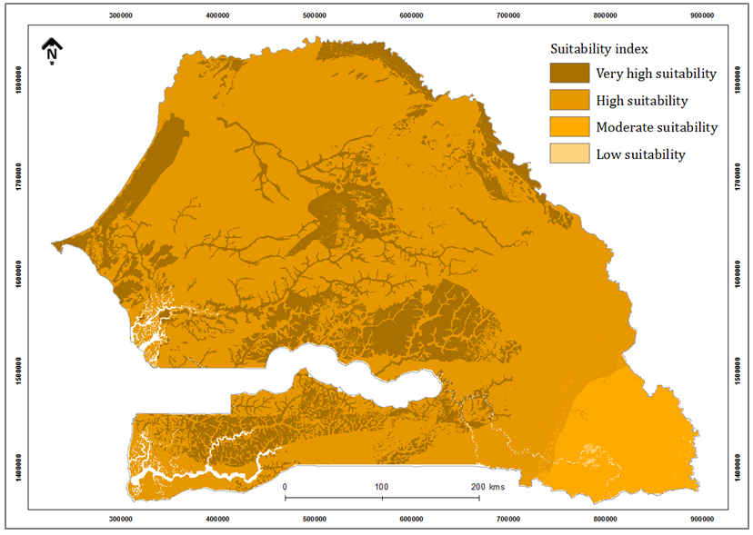 | Figure 4. Land Suitability for the Development of Retention Basin and Artificial Lakes in the study area |
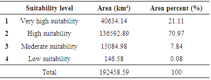 | Table 4. Suitability Ranks for the Development of Retention Basin and Artificial Lakes in the study area |

 : Average of sites identified as favorable areas on the fitness map;
  : number of sites identified by [18] corresponding effectively to the very highly suitable areas on the aptitude map.Table 5 shows that the quality of the overall accuracy is excellent, i.e. 0.81. At the regional scale, poor precisions are noted in the Kedougou region (0), and the Kolda and Ziguichor regions (0.4).
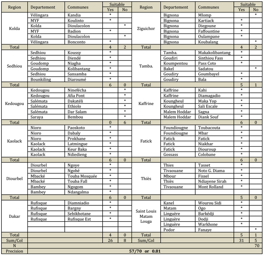 | Table 5. Validation of the regional aptitude map and calculation of the overall accuracy |
4. Conclusions
- This paper aims to map sites potentially suitable for the development of retention basins and artificial lakes. For this, our methodology combines GIS, Remote Sensing and MCE approach. These decisions tools are practical and flexible for the selection of suitable sites rapidly. In this study, 14 criteria layers were selected for the aggregation phase. They first underwent a pre-processing step which consists of harmonizing the layers (georeferencing and projection, conversion into raster mode, with 30m resolution). The criteria were weighted (with a relative weight assigned to each layer) and aggregated according to the WLC approach. The results of the aggregation show that approximately 21.11% of Senegalese territory is very highly suitable to the development of these structures. These areas are widespread throughout the country, mainly in the agro-ecological areas of Casamance, the Groundnut Basin, the Senegal River Valley and the Niayes area. This result has been validated with the work done by [18]. The overall accuracy of areas potentially very suitable is equal to 0.81, which is considered excellent. Indeed, these results can help decision-makers to limit working delay, exorbitant costs for such a study, and which require a high level of human resources. Real perspectives are thus offered to the public authorities in the intensification of agriculture to achieve the food self-sufficiency of the population.
 Abstract
 Reference
 Full-Text PDF
 Full-text HTML