-
Paper Information
- Paper Submission
-
Journal Information
- About This Journal
- Editorial Board
- Current Issue
- Archive
- Author Guidelines
- Contact Us
American Journal of Geographic Information System
p-ISSN: 2163-1131 e-ISSN: 2163-114X
2016; 5(1): 24-31
doi:10.5923/j.ajgis.20160501.03

Integrated a GIS and Multi Criteria Evaluation Approach for Suitability Analysis of Urban Expansion in Southeastern Jerusalem Region- Palestine
 Abstract
 Reference
 Full-Text PDF
 Full-text HTML
Samer Raddad
Department of Geography and Urban Studies, Al Quds University, Jerusalem, Palestine
Correspondence to: Samer Raddad, Department of Geography and Urban Studies, Al Quds University, Jerusalem, Palestine.
| Email: |  |
Copyright © 2016 Scientific & Academic Publishing. All Rights Reserved.
This work is licensed under the Creative Commons Attribution International License (CC BY).
http://creativecommons.org/licenses/by/4.0/

Although cities cover only less than 1% of the land surface, 50% of world population are living in urban areas that include more than 70% of the economic activities and use 75% of the world resources. Population, economy, transportation, and policies factors are identified as the main factors that affect urban expansion and development, especially in developing countries. Political transformations and instability conditions are among the most important factors effecting social, economic, and environmental aspects in the world especially in the countries and regions witnessed wars and political problems. In Occupied Palestinian Territories (OPT) the rapidly growing population, limited available decisions of policy makers, and political instability played a main role in the Palestinian urban expansion and development. Therefore, this study aims to define the most suitable area that should be developed in the Southeastern Jerusalem Region (SERJ) living under political instability conditions. Integrated the Geographical Information System (GIS) with Multi-Criteria Evaluation approach (MCE) Conducted to find the potential areas to be considered as urban development areas in the region. The modeling and analysis indicates four suitable classes and areas: highly suitable, highly moderate, suitable, and low suitable. Suitability map of urban expansion and development shows 77% of the study area consists of low suitable areas that are distributed in north and east of SERJ. The Palestinian urban policy makers need to pay more attention to urban development and expansion in the Southeastern Jerusalem Region because these areas are so close to the Jerusalem city in the west, and it is the last pass-point in the west bank between the north and the south. Policy makers, urban planners, urban mangers, and people need to show more awareness towards the sustainability urban planning issues, especially during political instability stages. Principles of urban smart growth will be useful ideas for promoting the sustainability in the Palestinian urban environments.
Keywords: Sustainable Urban Expansion, MCE, GIS, Suitability Analysis, Palestinian Urban Environments
Cite this paper: Samer Raddad, Integrated a GIS and Multi Criteria Evaluation Approach for Suitability Analysis of Urban Expansion in Southeastern Jerusalem Region- Palestine, American Journal of Geographic Information System, Vol. 5 No. 1, 2016, pp. 24-31. doi: 10.5923/j.ajgis.20160501.03.
Article Outline
1. Introduction
- Globally, 54% of the world’s people are living in the urban areas, and by 2050 66% of them will be living in cities [18]. Although cities, cover only a tiny fraction (< 1%) of the land surface, urban areas are the nexus of human activity with more than 50% of the population and 70–90% of economic activities, and they use over 75 % of the world resources [28] [9]. According to Angel [4] the urban land cover in developing countries will increase from 300,000 km2 in 2000 to 770,000 km2 in 2030 and to 1,200,000 km2 in 2050. So, urbanization leaded to resource depletion, increasing level of waste and pollution, and the reduction of species in the urban environments [22]. In 2011 Seto stated that the conversion of Earth's land surface to urban land uses is one of the most important human effects on the global biosphere. Therefore, analysing and detecting land cover/ land use change at different scales are essential processes in understanding various socioeconomic and environmental problems, which threat the future of the earth’s surface and humanity [23]. Population, economy, transportation, and political factors are identified as the main reasons that effect urban expansion and development, especially in developing countries [27] [11] [13]. Moreover, lack of regulations, laws, public awareness, information and professional capacity leaded to informal urban expansion and negative impact on urban environments [6]. The people continue moving into urban areas to seek better life and economic opportunities, Therefore, the practice of sustainable activities in the urban environments plays an important role in achieving global sustainability [31] [12]. According to Brundtland Commission, sustainable development means the “development that meets the needs of the present without compromising the ability of future generations to meet their own needs” [19]. Global awareness of speed and massive urban expansion is needed to better understand and plan for facing this challenge [4]. Therefore, national, regional, and local governments as well as civil organizations and some citizens need more efforts to cooperate together to promote the sustainability in the urban environments, especially in developing countries. So, urban growth management and control on our future urban expansion trends and process will be an important effect factor in the sustainability urban environment especially under instability conditions like Occupied Palestinian Territories (OPT). Political transformations and instability conditions are among the most important factors effecting social, economic, and environmental aspects in the world, especially in the countries and regions which witnessed wars and political problems. Urban expansion trends are impacted by these conditions while all of these changes and crises effecting urban land use change and spatial structure of the urban environment. Nuissl & Rink [19] focused on the impact of political transformations in eastern Germany, on the urban development process in eastern German cities. Xiao [35] showed the effect of the military defined walls on the urban spatial structure of land use in Shijiazhuang-China during 1950s. Worldwide, there are many places occupied by other countries and powers in history. For example, Czech was occupied by Germany during the World War II, and Latvia was later occupied by the Soviet Union from 1945-1991. These two examples showed military occupation that caused significant impact on the land use change through the transfer of the urban and rural communities as well as the farmers to other places. The political transformations at the regional level affected the urban development in the countries where the political events occurred. Moreover, it also caused significant impacts on the urban environments in the neighboring countries and cities. For example, Amman city, the capital of Jordan, is one of the cases where urban expansion and development in Amman-Jordan were impacted by many political transformations and events in the Middle East region such as the occupied parts of the Palestinian Territories by the Jewish groups in 1948, and the establishment of Israel, and the occupation of all Palestinian territories by the Israel army in 1967 as well as the second Gulf war in 1991. All of these wars and events leaded to the migration of the Palestinian and Iraqi refugee to Jordan, especially to Amman city which witnessed expansion as a result of these migration waves [24]. The Occupied Palestinian Territories (OPT) have witnessed many political transformations and events since the occupation by the Israeli Army of the Palestinian Land in 1967. The Israeli military administration controlled the urban development process until 1995, prior to the establishment of Palestinian Authority, which started to control urban development issues in some of the Palestinian urban localities [26]. Between 1990- 2005, there were many political events such as ASLO agreement and the establishment of the Palestinian Authority, as well as an increasing level of building Israeli settlements in the West Bank, and the construction of separation wall, which had significant impact on urban development and land use in the OPT [6]. In 1998 the Ministry Of Planning and International Cooperation (MOPIC) stated:“The Israeli territorial strategies of unrealistically limiting border expansion of cities and villages has overloaded infrastructure and increased population density in the built-up areas. It has also translated to the random, unplanned, and unlicensed construction of houses and urban sprawl. Furthermore, it has contributed to rural-urban migration by people who are unable to find housing in the rural areas” [17]. The Israeli–Palestinian conflict has negatively affected all elements of the natural environment including the quality of human life. [14] [16]. Therefore, the political factor is the major driving force which affected the urban development process and urban expansion trends in the Palestinian Urban Environment, and it is the main challenge facing urban development in the Palestinian urban environment [5] [30] [25]. Consequently, the future of the OPT is uncertain, restrictions on the available land and recourses will lead to more degradation in the Palestinian environment especially, in the urban and pre-urban areas.Various human activities require different land uses. Therefore, we need to allocate different land uses in a way that would support one type of land use while respecting other uses. Suitability means supporting a proposed land use through considering a number of factors such as society, economy, environment [34]. Decision making is a sequence of activities that starts with identifying a problem and ends with recommendations for a decision. The quality of decision depends on the quality of the activities that are carried out during the decision making process [36]. Multi Criteria Evaluation (MCE) is a method of analyzing land suitability evaluation. Likewise, it is a decision making tool to support policy makers for sustainable development, conflicting in the land use game such as ecological, economic, social, and political players. Land suitability maps can help urban planners, managers, and policy makers in the urban environments. Many empirical studies were conducted by adopting a MCE approach to find the suitable sites for urban development and land use [33] [3] [8] [15]. In the Palestinian context, some empirical studies integrated GIS with MCE methods and found them as power tools to promote the urban development process at urban and regional levels [2] [5].In the Occupied Palestinian Territories (OPT) the rapidly growing population, limited available, decisions of policy makers, and political instability played a main role in the Palestinian urban expansion and development. Therefore, Palestinian policy makers, planners, and managers need more attention towards evaluating lands for urban expansion and development in the urban environments under political and geopolitical impacts. They also should promote sustainable development. This study aims to define the most suitable area to be developed in the Southeastern Jerusalem Region by integrating the Geographical Information System (GIS) of Technology with MCE approach to find the potential areas to be considered as urban development areas in the study area and help the Palestinian to support the sustainability development.
2. Study Area
- The study area is located in the southeastern part of Jerusalem Governorate which is located in the middle of the West Bank (figure 1). Southeastern Jerusalem Region (SEJR) including Az Za'ayyem, Al 'Eizariya, Abu Dis, 'Ara al Jahalin, As Sawahira ash Sharqiya, and Ash Sheikh Sa'd are Palestinians localities with a area of 91 km2 and a population of 40260 [21]. According to Applied Research Institute there is an estimated number of 41714 Israeli settlers in Southeastern Jerusalem Region living in three Isreali settelments that include Ma'ale Adumim, Mizpe Yedude (New Kedar), and Kedar (Old Kedar) [7].
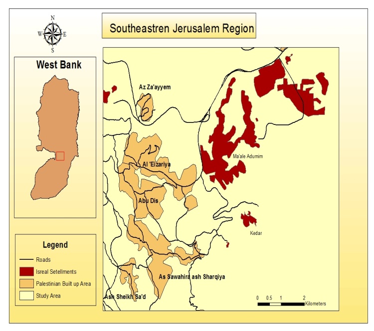 | Figure 1. Study area |
3. Methodology
- Geographic Information System (GIS) is a powerful tool for urban planners in their effort to be efficient and effective in the urban development process. The evaluation of land use in the urban planning context is a very complex process because it is need to consider many social, economic, and environmental factors. This study attempts to transform the spatial and non-spatial data from input data into result decision based on combining GIS and MCE to define suitable lands for sustainable urban expansion and development in the study area. To identify these areas as shown in figure (2), the researcher has developed a chart based on four steps: the first identifies the main factors effecting urban expansion in the Palestinian context, the second is for scoring and weighting the factors in the MCE framework, the third is for modeling the impact of the factors with model builder tool in the Arc GIS software as shown in figure (3), the fourth is to conduct the suitability analysis by integrating the GIS and MCE to find the suitable areas for urban expansion and development in the Southeastern Jerusalem Region. Suitability model in GIS can be conceptualized as:
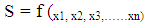 where S is suitability index and 123n are factors affecting the suitability of the sites for urban development. Assessing suitability of grid cells by weighting and combining factor maps. After assigning factor scores and weights, suitability score was calculated by using the following formula:
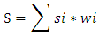 where, S, is the sum of the product of the individual weight, wi , and the score, si for each factor, i.. The importance of factors are related to show how individuals and groups are thinking about these factors.
 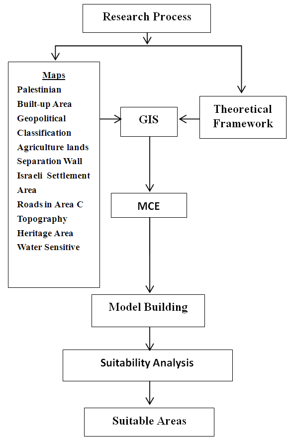 | Figure 2. Research Process |
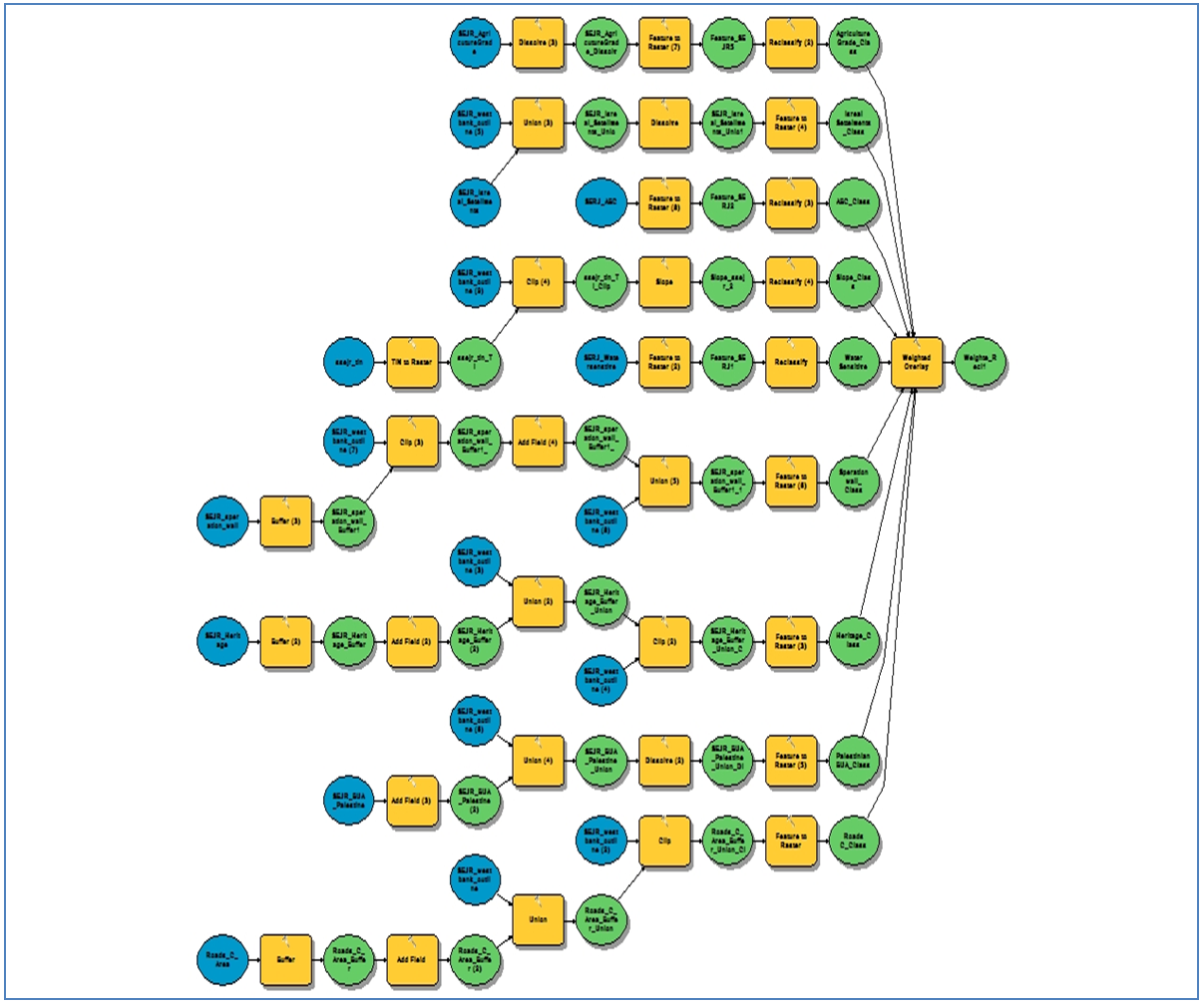 | Figure 3. Model of Urban Expansion and Development |
|
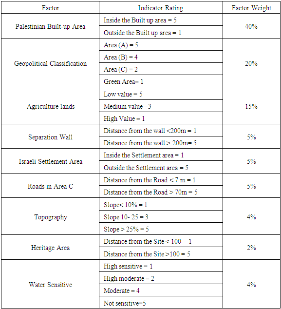
 | Figure 4. Suitability Maps of Urban Expansion Parameters |
4. Results
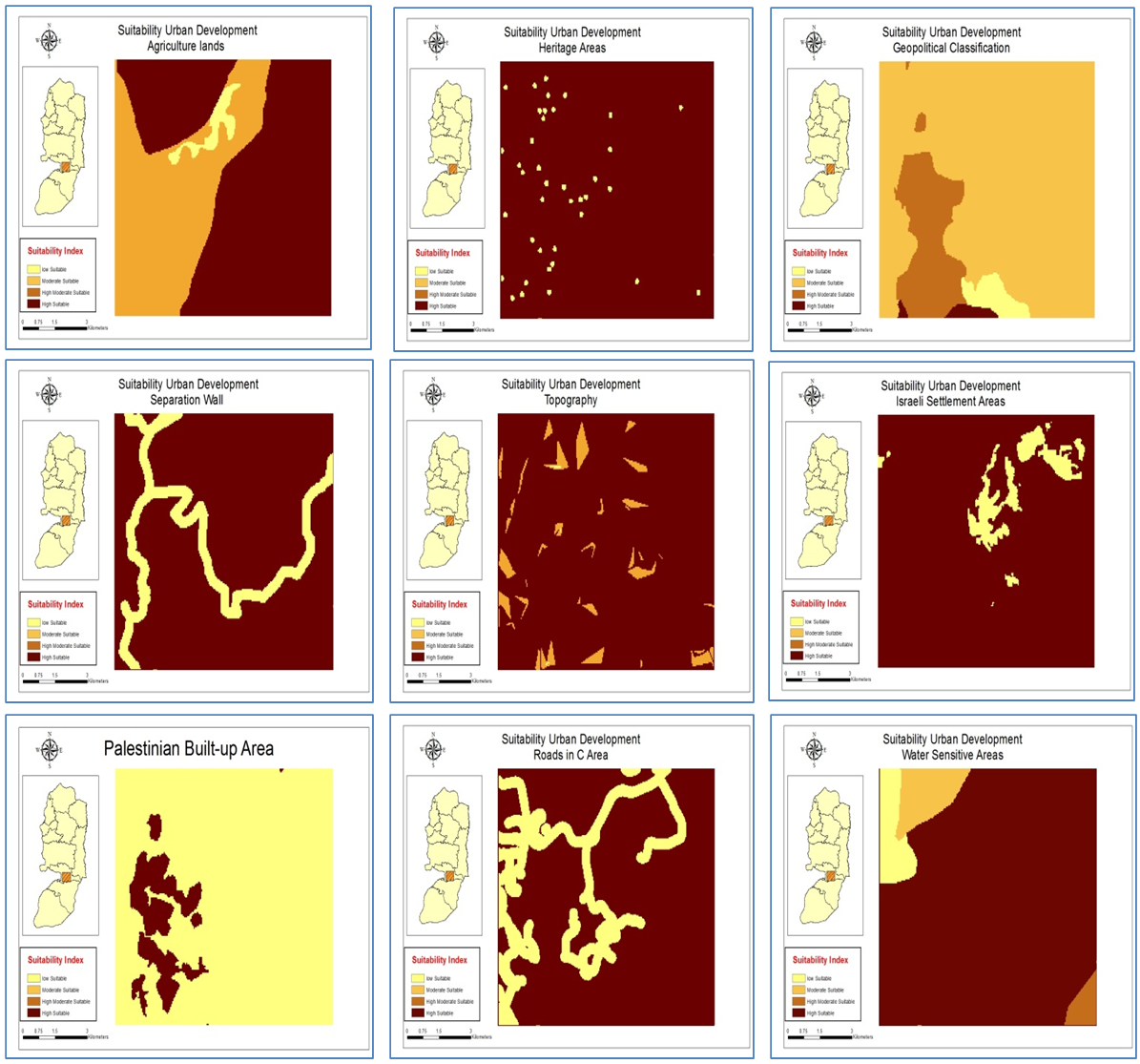
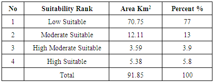
- The results were obtained after the analysis showed in Suitability map of urban expansion and development figure (5) that shows different urban development suitability in different areas in Southeastern Jerusalem Region. Table (2) indicated areas and percentages of different land suitability in the study area. Highly suitable area occupied 5.38 km2 of the total area, and it is located inside the Palestinian localities, which means that urban development will increase speedily in the built-up during the short-term and mid-term future. Highly moderate area of 3.59 km2 is distributed in the Palestinian urban regions and close to localities because the power of the geopolitical factor such as the separation wall in the west pushing the suitability urban development into the east. Therefore, we can signal these areas as the smallest areas in the suitability urban development class table (2). Moderately suitable area of 12.11 km2 is located and distributed between the Palestinian urban localities in the Southeaster Jerusalem region as shown in figure (5). It is also distributed in different areas with desperate pattern as a result of the conflict and interaction of various impact factors that affect the urban development in the study area. Low Suitable area of 70.75km2 is distributed on most of the lands in the study area with high impact of Geopolitical factors such as the Israeli settlements, the separation wall, and geopolitical class figure (1 & 5).
 | Figure 5. Suitability of Urban Expansion and Development |
|
5. Discussion and Recommendations
- GIS and multi-criteria evaluation approaches are integrated to find the suitable areas for urban expansion and development in the Southeastern Jerusalem Region in terms of promoting urban sustainability in the Palestinian urban environments. In the context research, the modeling and analysis indicate four suitable classes and areas such as highly suitable, highly moderate suitable, and low suitable. Suitability map of urban expansion and development illustrate 77% of the study area consisting of low suitable areas that are distributed in north and east of SERJ. According to suitability urban development, agricultural lands and water sensitive factors in figure (4) are the best choice for natural future Palestinian urban expansion and development, but according to geopolitical classification factor in figure (4), these areas are the worst areas for future Palestinian urban development because no chance for Palestinian to expand on these areas under the geopolitical factors impact. On other hand, only 5.8% for High Suitable and 3.9% for High Moderate Suitable lands for urban expansion and development. This situation is strongly forcing the Palestinian to direct growth in urban areas, therefore Palestinian urban areas in the study area will face a high density of built up area in the future years. Without control on the planning sector in the study area and under these situations the Palestinian urban areas will face a serious socioeconomic and environments problems and challenges. These findings agreed with most of the Palestinian research effort about the urban expansion and development [1] [14] [16]. Therefore, the Palestinian policy makers and urban mangers need to answer the major and complex question of how they can promote the sustainable development in the Palestinian urban environments under the political instability. The Palestinian urban policy makers need to pay more attention to urban development and expansion in the Southeastern Jerusalem Region because these areas are so close to the Jerusalem city in the west, as well as, it is the last pass point in the west bank between the north and the south. Policy makers, urban planners, urban mangers, and people need to be more aware of the sustainable urban planning issues, especially under political instability stages. Principles of urban smart growth theories will be useful bases to help the Palestinian planners and policy makers in promoting sustainability in the Palestinian urban environments especially, under these challenges such as multifunctional land uses, compact communities as well as promoting public transportation. Palestinian national and local authorities need to prepare a strategic regional plan for the land use in the southeastern Jerusalem region. Also, they need to establish policies addressing the sustainable development that should cover various fields like urban rehabilitation, land use, transport systems, energy management, conservation policy, and cultural policy. They need to enhance public awareness and participation in urban planning process towards respecting the building and planning laws and regulations and share them in the urban development projects and plans. Also, Integrated the NGOs and private sector in the urban planning process and development will be a very useful in any future urban development.
6. Conclusions
- Growing Palestinian people with high rate, limited lands for development, and impact of the political and geopolitical factor put the Palestinian policy makers and urban mangers face to face with a big challenge in the future urban development process. The Palestinian need for political stability in the country because it is the most significant factor in achieving any progress in controlling and managing the development and expansion. But, Palestinian urban planners and policy makers should prepare a new ideas, policies, and plans with different scenarios that a suitable working under political instability conditions and very limited areas for future urban development. GIS technology, combined with MCE, are practical and flexible tools for selecting potential areas for sustainable urban development in the urban planning context. Finally, this study will improve our knowledge in the urban development research context about the relationship between the urban expansion trends and the geopolitical pressure and push us to pay more research and practical efforts at different levels for promoting people to stay on their lands and in their cities, towns, and villages with a high level of abilities to improve their life through creating economic growth, social development, and environmental protection.