-
Paper Information
- Paper Submission
-
Journal Information
- About This Journal
- Editorial Board
- Current Issue
- Archive
- Author Guidelines
- Contact Us
American Journal of Geographic Information System
p-ISSN: 2163-1131 e-ISSN: 2163-114X
2015; 4(2): 64-75
doi:10.5923/j.ajgis.20150402.02
Dynamic Road Segmentation of Part of Bosso Local Government Area, Niger State
Oluibukun G. Ajayi, Joseph O. Odumosu, Hassan A. Samaila-Ija, Nanpon Zitta, Ekundayo A. Adesina, Olaniyi J. Olanrewaju
Department of Surveying and Geoinformatics, Federal University of Technology Minna, Nigeria
Correspondence to: Oluibukun G. Ajayi, Department of Surveying and Geoinformatics, Federal University of Technology Minna, Nigeria.
| Email: |  |
Copyright © 2015 Scientific & Academic Publishing. All Rights Reserved.
Dynamic road segmentation (DRS) data model finds maximum application in GIS Transportation (GIS-T) studies and analysis; serving as a data model that splits linear features into new set of segments wherever its attributes change. Attempt has been made by this research to carry out the Dynamic road segmentation of part of Bosso Local Government Area of Minna using an IKONOS image of 1-m Pan-sharpened spatial resolution and other field survey acquired data. Geometric data was acquired using Handheld GPS receivers while the attribute data was acquired via the social survey approach (administration of questionnaires, direct observations and on-site interviews). A Geo-database was designed and created within the Arc GIS 10.0 version software environment. Analysis and queries were also performed to solve some pertinent issues concerning the route segments and to highlight the closest infrastructural facility in case of emergencies. The result highlighted the present road pavement condition of the considered road segments, adjacent land use, traffic congestion rate, notable crime spots and accident hotspots. It also suggested that the building up of traffic congestion along the Kpakungun round about axis is due to the road width (8m), high traffic volume and the dilapidating state of the road’s pavement.
Keywords: GIS in Transportation (GIS-T), Road Network, Dynamic Segmentation (DS), Database, Adjoining Land Use, Linear Referencing, Road Traffic Accident
Cite this paper: Oluibukun G. Ajayi, Joseph O. Odumosu, Hassan A. Samaila-Ija, Nanpon Zitta, Ekundayo A. Adesina, Olaniyi J. Olanrewaju, Dynamic Road Segmentation of Part of Bosso Local Government Area, Niger State, American Journal of Geographic Information System, Vol. 4 No. 2, 2015, pp. 64-75. doi: 10.5923/j.ajgis.20150402.02.
Article Outline
1. Introduction
- Dynamic Segmentation (DS) which efficiently manages heterogeneous attributes along linear features, is a method of linear referencing that ensures the referencing of a road or other linear features without breaking such features into pieces. It is the process of computing the map locations of events stored and managed in an event table using a linear referencing measurement system and displaying same on a map (ArcGIS 10.1 Help file). This technique affords that multiple sets of attributes be associated with any portion of an existing linear feature independent of its beginning or ending node. Dynamic Segmentation data model is a term in Geographical Information System for Transportation (GIS-T) analysis, which generally refers to a data model that splits linear features into set of new segments whenever changes occur in their attributes.Dynamic segmentation places lengths of road into categories of quality based on the roughness and rutting of both its own sequence and that of neighboring segments. This also enables the integration of this data with GIS software, which could then be adapted to an integrated highway information system (James et al, 2000). Dynamic segmentation can also be defined as the combination of multiple sets of values to any portion of a linear feature based upon trends in the data. This differs from static segmentation where the data is always segmented at rigid boundaries (James et al, 2000).This technique (DS) computes the map locations of linearly referenced data (for example, attributes stored in a table) at run time so they can be displayed on a map, queried, and analyzed using a GIS. The dynamic segmentation process enables multiple sets of attributes to be associated with any portion of a line feature without segmenting the underlying feature. In the transportation field, examples of such linearly referenced data might include accident sites, road quality, and traffic volume. Boroujerdian et al (2014) applied Dynamic segmentation method for the identification of location as well as the length of high crash road segments, focusing on the location of occurred accidents along the road and their effective regions. Their experimental result showed an improvement of 25-38 percent in relative to other existing methods. A road maintenance data model using Dynamic Road segmentation technique which was successfully implemented on the Iranian road networks was proposed by Mohammed et al (2009). Christopher (2004) explored the dynamic segmentation functionality in ArcGIS using a typical road management data, a case study of the Brazos County. The findings of his research suggested that the level of compatibility between the network referencing system and the route development process in ArcGIS can influence the manpower effort to implement dynamic segmentation considerably. It also submitted that ArcGIS does not fulfill all the needs of road management spatial analysis and that additional data transformation tools are needed to fulfill this role. Dave (2003) also applied Dynamic segmentation for the analysis of forest road sediment production. His study presented a GIS/database system and the associated field inventories used to document and manage a suite of point and linear events using dynamic segmentation at a one foot resolution. These derived spatial features were then used in an analysis of sediment production rates throughout the road system routed through a series of hydrologically connected events derived from the dataset and defined as network elements.DS allows the storage of every feature as a separate entity while having only one reference over which all attributes are referenced (Mohammed et al, 2009). It considerably increases the ease of displaying road management data spatially, though manpower effort needed to implement dynamic segmentation to road management systems may increase considerably if manual intervention is required or adopted in the development stage (Christopher, 2004).Using GIS as the tool for maintaining and monitoring road network system will open up a wide range of possible applications, such as increase in traffic and road condition data acquisition and processing. This will ensure quick and convenient access of relevant and necessary information requisite for planning, design costing and execution of road network project thereby proffering solution to the lingering multivariate problems that are associated with road transportation especially in third world countries like Nigeria.In many Nigerian cities, the conditions of connecting road network are mostly dilapidated, not properly maintained or not well designed thereby causing increase in travel time, traffic congestion, increase in road traffic accidents, among other adverse consequences. The cause of this can be traced to successive government’s neglect, overstretched workloads, out-lived design lifespan, structural design defects, sub-standard construction materials and other natural phenomena (Ajani, 2001). GIS application is the best alternate technique used by developed countries in solving these problems by carrying out spatial analysis of the road network usages, thereby informing users on how to locate the road that leads to their desired destinations, within the shortest distances.Wuboys (1995) described GIS as a computer based information system that enables capture, modeling manipulation, retrieval, analysis and presentation of geographically referenced data. He also gave example of areas of applications in GIS i.e. resources inventing, network analysis, terrain analysis, location analysis, spatial analysis, temporal information analysis. Kufoniyi (1998) stated that the content of spatial database component of GIS depends on the application for which the system is planned.Using GIS-T as a tool, this paper seeks to map out and analyse the road pavement condition, nature of adjacent land use, notable crime zones and accident prone areas within the study area. Analysis that queries information such as shortest or longest routes (i.e. optimal routes) to some public facilities like: hospital, fire service station etc. were also performed on the created Geo-database of the study area.
2. Study Area
- The study area is part of Bosso local government in the city of Minna, Niger State, Nigeria. Bosso and environs is the center and major metropolitan of Minna the capital city of Niger State. It lies between Latitudes 9° 31¹ and 9° 40¹ North of Equator, and Longitudes 6° 29¹ and 6° 35¹ East of Greenwich Meridian and has a land mass area of about 884 hectares. Figure 1 shows a diagrammatic presentation of the study area.
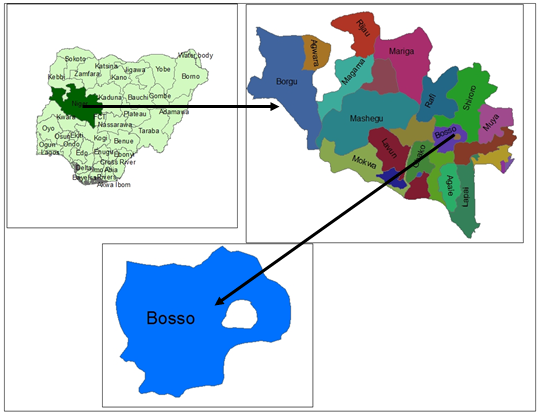 | Figure 1. Plate Showing Maps of the study area |
3. Methodology
- The general model of the work flow for this research is presented as Figure 2. A schematic diagram of the design and construction phases of a spatial database can be accessed in Kufoniyi (1998).
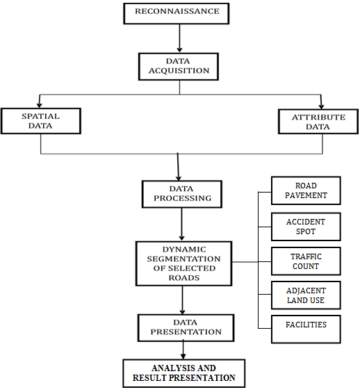 | Figure 2. Model of Work Flow of the study |
3.1. Data Acquisition
- Geometric data were acquired using digital land surveying method while attribute data was acquired through social survey (visualization, direct interviews and questionnaire). Five points were coordinated by Differential Global Positioning System (DGPS) receivers which were used for georeferencing purpose. The X and Y coordinate of other notable points (such as beginning and end nodes of road segments, crime and accident spots, notable road features such as potholes, etc.) were acquired using Garmin 76 Handheld GPS receivers. The satellite image was obtained from the Department of Surveying and Geoinformatics, Federal University of Technology, Minna. The image was acquired in 2005 with a scene dimension of 4km by 6km and spatial resolution (pixel size) of 1m.
3.2. Entity Relation-Diagram for Conceptual Design
- The relational network of the study area to the origin of the research as described by Entity Relational Diagrams (ER-Diagram) is herein described in Figure 3. Road network is one of the criteria to define a town. Minna being a town in Niger State has certain defining multi-valued attributes of which road system is fundamental.
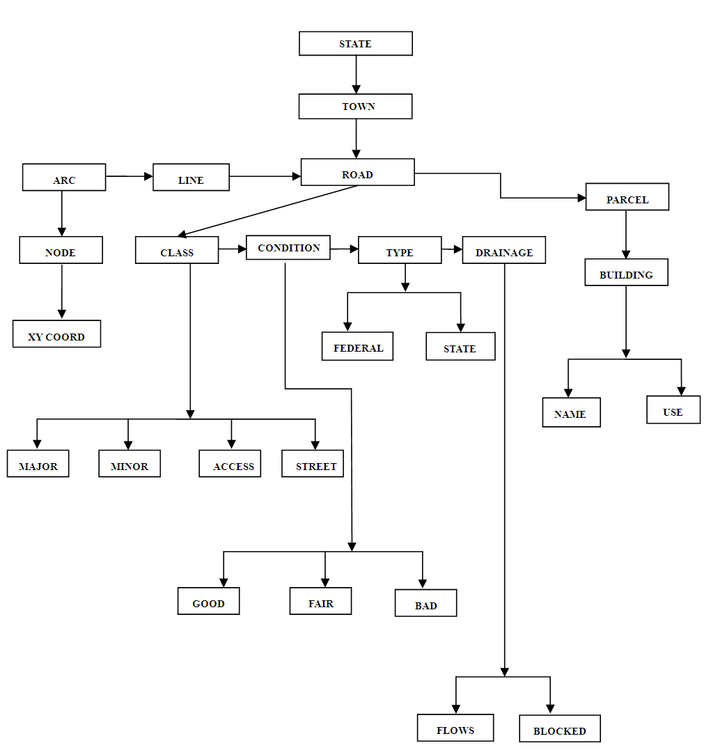 | Figure 3. Township Road Networks Entity Relation Diagram (Source: Authors’ research) |
3.3. Database Design and Creation
- Database is an organised integrated collection of data stored so as to be capable of use by relevant application with data been accessed by different logical paths (Kufoniyi 1998). The database was created for the integration of the information of points, lines and polygonal features together with some attribute data using a relational data structure wherein features and their attributes were recorded into the appropriate field and tuples.
3.4. Attribute Data as an Entity
- The relationship between entities and their attributes are presented in Figure 4. It also highlights their unique identifier (ID), entity type, class, and other attributes that best describes the entities.
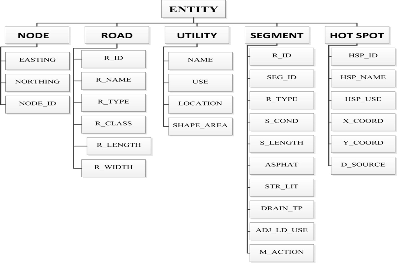 | Figure 4. Entities and their Attributes (Source: Authors’ research) |
3.5. Data Integrity
- Database integrity is ensuring that the data in the database is accurate. Optimal care was ensured while inputting and processing the data. Data integrity was also ensured, by permitting a database administrator to design validating procedures to be carried out when ever an update operation is attempted.
3.6. Testing of Database
- This involves ensuring the overall workability of the data base in terms preservation of data integrity during storage and/or retrieval process (Oguntade, 2005). This was done by designing a sample query and running the query to see if the desired result is achieved.
3.7. Queries
- Queries were designed for the purpose of retrieving information from the designed database. It is a way of obtaining specified information from the database using appropriate commands or syntax. Spatial query and analysis for this paper was carried out on features with certain characteristics related to the study area. The queries performed were based on the available database to answer certain generic questions asked from the database.
4. Results and Discussion
- The result of the single and multiple queries performed on the database are presented as Figures 5 and 6 respectively. The first query seeks to highlight the segments of the road that are in good condition while the second query attempts to highlight the segments of the major road that needs to be repaired or which is in a fair condition (See sub-sections 4.1 and 4.2). The result of the network analysis is presented in Subsection 4.3 while subsection 4.4 presents the adjoining land use map (Figure 10) and the compostie map showing the accident spots, crime hotspots, location of potholes and nodes defining various road segments (Figure 9).
4.1. Single Criterion Query
- A single criterion query was carried out where one condition is used for the design query. QUERY1Determination of the available segmented roads that are in good condition within project area. This is shown in Figure 5Type of analysis: Single criterionSyntax model: [S_Cond]= “G”
4.2. Multiple Criteria Query
- This is the situation where two or more conditions are imposed in a query operation. Here, the two conditions imposed include the road class (major roads) and the road pavement condition (fair condition).QUERY2Determination of available major roads that are in a fair conditionType of analysis: multiple criteria query. Syntax model: R_Class= “Major” AND S_Cond= “F”
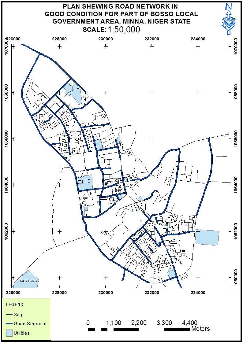 | Figure 5. Extracted roads in good condition within project area |
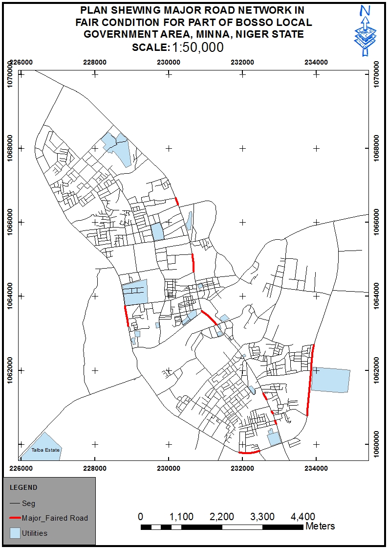 | Figure 6. Map of the available major roads that are in fair condition |
4.3. Network Analysis
- The result of the optimal route analysis for a journey from FUT Mini campus located in Bosso (Starting point) to Kure Market located along the Western Bypass (Destination) is presented in Figure 7 while the route directions with the expected travel time is shown in Figure 8. Based on our study, the journey should take an average travel time of 3 minutes and 4 seconds or a maximum of 4 minutes.
4.4. Presentation of the Road Segmentation
- Figure 9 shows the dynamic road segmentation separated with nodes, the road segments, crime scenes and notable potholes location. The result shows that there is a relationship between the frequency of road accident and the road pavement condition. Objectively, high accident rates were recorded on major roads with a handful of potholes. Such roads also experience traffic congestion even as most road users and commuters complain of difficulty in road navigation. Examples of such road segments include the Kpakungun round about axis, Shiroro road, Mobil round about axis, etc. High congestion rate was also recorded along the Kpakungun Round about axis, Mobil Round about, Bosso-Mobil Road, etc.Figure 10 shows the adjoining land use along the road segments. The notable adjacent land use was categorized into the Residential land use, Commercial land use, Residential/Commercial land use (Such as houses that was originally designed for residential purposes but now accommodates business ventures) and the Industrial land use. Mostly, along the major road segments, it was discovered that there are business shops signifying commercial land use and after some 50m to 100m inward we have residential land use. It was also recorded that there is only one industrial land use (located at the north western end of the western bypass) within the study area as at the time of conducting this research.
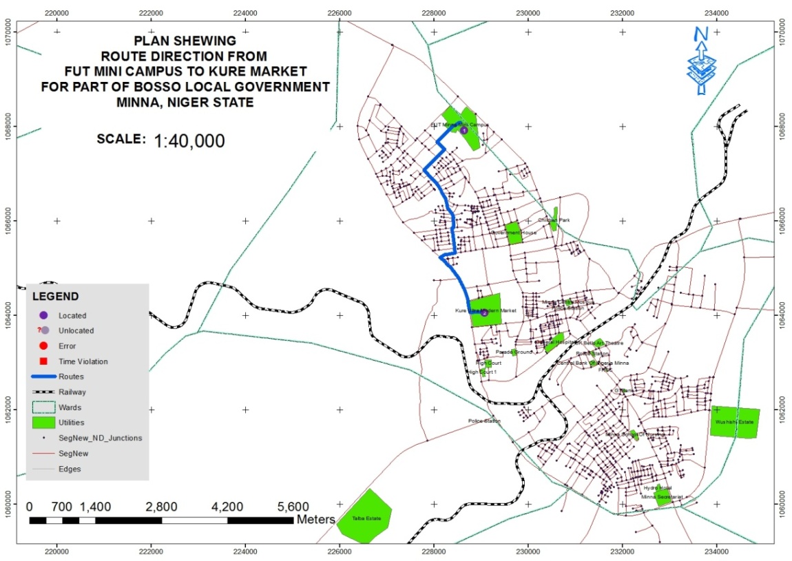 | Figure 7. The result for the optimal route between FUT Mini Campus (Starting point) and Kure market (destination) |
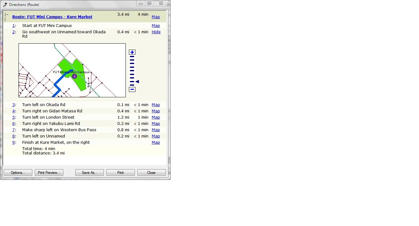 | Figure 8. Route direction from starting point and the destination |
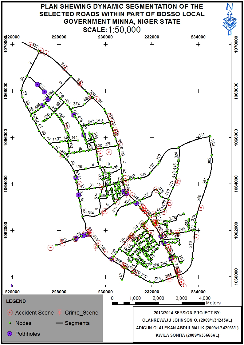 | Figure 9. The result for the available potholes and crime scene |
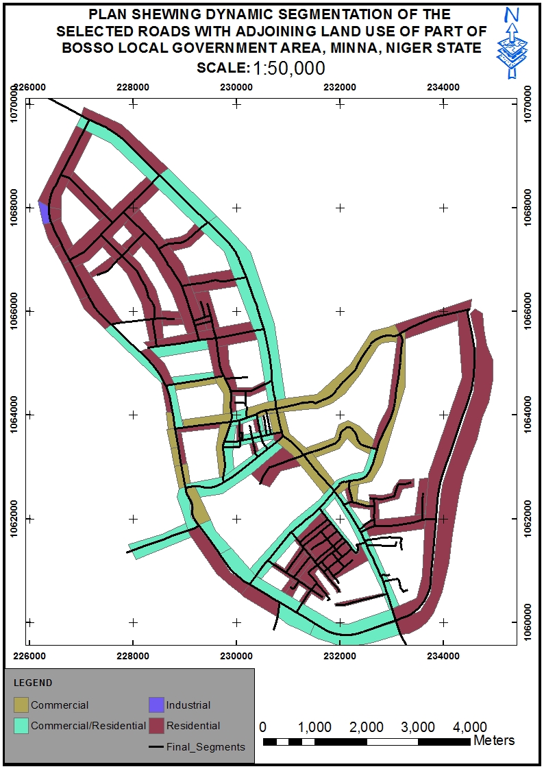 | Figure 10. Map for the adjoining land use of part of Bosso LGA, Minna |
5. Conclusions
- On the average, a greater portion of the pavement of Minna roads can be said to be in good condition. It was observed that Road Traffic Accidents (RTA) are more prominent on roads with poor or bad pavement, segments without proper road signs, segments with commercial adjacent land use etc. and that such roads riddled with potholes also records highest frequency of traffic congestion and as such, increase in travel time. The most prominent adjoining land use along the considered road segments is the residential land use while only one industry was observed to be operational within the studied area as shown on the adjacent land use map (Figure 10). It was also observed that the traffic volume that constitutes the workload on the Kpakungun axis which connects Minna to Bida is too heavy for the road width thereby contributing immensely to the traffic congestion frequently experienced at the Roundabout end of the road axis especially between time ranges of 0745Hours to 0945Hours (morning hours) and between 1545Hours to 1645Hours (evening hours) of the week days. This research suggests urgent repairs or rehabilitation of some pothole-riddled segments of the road and an expansion of the road width. It is also suggested that an alternate route be constructed to solve the reoccurring problem of traffic congestion in the Kpakungun axis.Finally, the technique adopted for this research is the dynamic segmentation of linear features using some of the road networks within Bosso LGA of Minna, Niger state, Nigeria as a case study. The technique offers an improved method of spatial data analysis and presentation, it considerably increases the ease of spatially displaying road management data and it is applicable to all linear features (node-to-nodes, node-to arcs, etc.), though road network has been experimented in this research using manual intervention. Future researches will look into the development of a real-time dynamic road segmentation model. This approach will create an online platform for automatic monitoring of these road features and updating their geo-database as soon as any change is observed.
AKNOWLEDGEMENTS
- The authors would like to thank Miss Kwila Sonita and Mr. Adigun Abdulmalik of the Department of Surveying and Geoinformatics, Federal University of Technology, Minna, for their immense contribution during the data acquisition stage of this research.
 Abstract
 Reference
 Full-Text PDF
 Full-text HTML