-
Paper Information
- Paper Submission
-
Journal Information
- About This Journal
- Editorial Board
- Current Issue
- Archive
- Author Guidelines
- Contact Us
American Journal of Geographic Information System
p-ISSN: 2163-1131 e-ISSN: 2163-114X
2014; 3(4): 147-157
doi:10.5923/j.ajgis.20140304.01
An Assessment of the Existing Continuously Operating Reference Stations (CORS) in Nigeria: An Exploration Using Geographical Information System (GIS)
Ali I. Naibbi1, Samir S. Ibrahim2
1Department Geography University of Portsmouth, Portsmouth, UK
2Office of the Surveyor General of the Federation of Nigeria, Garki II Abuja Nigeria
Correspondence to: Ali I. Naibbi, Department Geography University of Portsmouth, Portsmouth, UK.
| Email: |  |
Copyright © 2014 Scientific & Academic Publishing. All Rights Reserved.
The modernisation of the Global Navigation Satellite Systems (GNSS) has brought about significant changes in the methods of positioning and navigation. More recently, countries are adopting the continuous observation and measurements using a network of GNSS receivers called Continuously Operating Reference Stations (CORS) as the standard. For example, Nigeria has established 11 permanent GNSS Network (NIGNET) or CORS since 2008, which has provided the incentive for the adoption of the geocentric datum in all its geodetic activities. Unfortunately, the spatial coverage of the Nigerian CORS stations on a distance of more than 300km (between the stations) seems inadequate based on the global station densification standard of the International Terrestrial Reference Frame (ITRF). This study explores the CORS network and determines the suitability of improving the density of the existing CORS stations with a view to extending their spatial coverage in Nigeria. Data obtained from various sources are processed and analysed using buffer and Digital Elevation Model (DEM) techniques. The result shows that the existing CORS stations in Nigeria only covers about 25% of the country. Therefore, the study proposes new CORS stations that improve the distribution and the spatial coverage of the existing stations (to about 96%) in line with the ITRF’s standard.
Keywords: CORS, AFREF, Nigerian Geocentric Datum, GNSS, NIGNET
Cite this paper: Ali I. Naibbi, Samir S. Ibrahim, An Assessment of the Existing Continuously Operating Reference Stations (CORS) in Nigeria: An Exploration Using Geographical Information System (GIS), American Journal of Geographic Information System, Vol. 3 No. 4, 2014, pp. 147-157. doi: 10.5923/j.ajgis.20140304.01.
Article Outline
1. Introduction
- The establishment of survey control points involves the transfer of the control points closer to the site of the survey, which provides a geospatial data infrastructure in the area, and also assist the user with an easy access to reliable controls. Survey control points helps in the sustainable management of spatial data [1] and also plays a vital role in Navigation, Geodetic Surveying, Mapping, Photogrammetry, Civil Engineering and Geographic Information Systems (GIS). This present study investigates the existing surveying control points used in Nigeria and offers recommendations to improve their spatial coverage.The national mapping of Nigeria relates to the old systems of surveying (basic surveying procedures), which depended on using chains, the odolites and traversing techniques to establish the primary triangulation network of the country in the 1960s [2]. These traditional survey control systems are referenced to a non-geocentric datum (based on Clark 1880 ellipsoids) referred to as the Minna datum (L40) [2]. The L40 datum, which is regional in nature, has the following adopted geodetic co-ordinates; Latitude φ = 09° 38′ 09″ N, Longitude λ = 06° 30′ 59″ E, Height H = 279.6m above the geoid [3]. The old survey technique faces some deficiencies such as the absence of Geoidal height model [4]. The Geoidal height model is a mathematical model of the earth that uses gravity measurements to correspond with the mean ocean surface level on the earth [5]. Another deficiency that the old survey technique faces is that of transformation parameters, which involves the shift from one datum to another (local datum to global datum and vice versa). These are difficult to determine due to the old methods used in establishing the datum [5]. This suggests that there is a need for an upgrade (of the old survey techniques) to improve the accuracy of surveys and mapping activities in Nigeria for suitable and sustainable development. The adoption of geocentric coordinate frames as a national geodetic datum has now become the common trend [2] in both developed (for example, United States of America (USA), United Kingdom (UK), Austria)and developing countries (for example, South Africa and Kenya). For example, the space based technology made it possible using satellite to establish geocentric datum [2]. The high level of developmental activities in Nigeria in the areas of construction, power transmission, mechanised farming and so on, suggests the need to expand and update the Nigerian Primary Geodetic control Network (NPGN), and employ the geocentric datum that are commonly used in other countries. This will provide an avenue to meet up to the world standard, as well as to satisfy user’s high expectations (engineers, town planners, surveyors, geographers etc.). Even though, Nigeria has already established 11 permanent GNSS Network (NIGNET) of Continuously Operating Reference Station (CORS), this study examines the spatial coverage of these existing CORS network (as part of the Nigerian Geocentric Datum (NGD)), with a view to suggesting ways of improving their standard in line with the International Terrestrial Reference Frame (ITRF).
1.1. Geographical Location of Nigeria
- Nigeria lies between latitudes 4° and 14° N and longitudes 2° and 15° E, and is located in the western part of Africa [6]. The country has a total area of about 923,768km2 making it the 32nd largest country in the world [7]. It shares about 4,047km borders with four countries (Benin Republic to the west, Niger Republic to the north, Chad to the north-east and Cameroon to the east- see Figure 1). It has a coastline of at least 853 km that stretches along the Atlantic Ocean in the southern border.
 | Figure 1. Map of Nigeria (Source: Adapted from Porter et al. [8], p.372) |
2. Background
2.1. Continuously Operating Reference Station (CORS)
- Nicholas ([8]) defines CORS as Continuously Operating Reference Station, which can take the place of a traditional base station used in differential GNSS positing. CORS can give an instant high positional accuracy of ± 20 mm. CORS Network began in 1994 when NGS officially installed permanent GPS receiver in the National Institute of standards and Technology, Gaithersburg Campus, Maryland, and few months later in Colorado, which were later incorporated with three other continuously operating GPS stations that are originally part of CIGNET to become the first five stations in CORS Network ([9 -10]). By 2000, more than 200 CORS stations are installed and incorporated into the NGS’ CORS Network. By the first quarter of 2014, the CORS network increased to more than 1,900 sites, which is why it is now regarded as the primary source for geodetic survey community to access National Spatial Reference System (NSRS) data.CORS networks are now established in different countries and by different organisations due to its high geodetic data accuracy (± 20 mm). The development of CORS networks are categorised into three tiers as noted by Rizos ([11], p.10). These are as follows;(1) Tier 1 stations are the stations with International Global Service (IGS) grade 1 standards(2) Tier 2 stations as National Geodetic Network, and (3) Tier 3 stations are networks established by private institutions, state and local agencies. Schwieger et al. ([12], p.7) noted that the Tier 1 stations are high accuracy stations (± 20 mm) with class 1 geodetic receivers and well stabilised antenna monument capable of tracking any Regional Navigation Satellite System (RNSS) and GNSS signals. These stations are used to define and establish global reference frame and are also used in scientific research and geodetic sciences. Similarly, the Tier 2 are also high accuracy stations, but are maintained at state and national government levels. They are also equipped with good quality geodetic receivers and their antennas are stationed on a stabilised monument. They can also track signal broadcast from GNSS and RNSS. These stations are mostly established for the purpose of national geospatial reference frame (geocentric datum). Conversely, the Tier 3 are high stations but with minimum requirements compared to tier 1 and 2 stations. The Tier 3 stations are mostly established by local government, state, private organisations and agencies for positioning purposes. They are also referred to as “fit for purpose” stations. They are equipped with receivers that can track interoperable GNSS and RNSS signals.CORS stations are now established as networks that define regions at local, continental and global level due to its stability, continuity and effectiveness [9]. However, associations of scientists, geodesists and other earth observing bodies that form the first global reference frame (consisting of GNSS sites) established specifications for establishing CORS stations across the globe through the ITRF [12]. The ITRF reference systems are made to be a standard for all geodetic and earth science fields (see for example, [13-15]). The main task of the ITRF as noted by Schwieger et al. ([12], p.2) is to” maintain the stability and to provide open access to the geometric and gravimetric reference frames as well as time series of data and products, by ensuring the generation of uninterrupted state-of-the-art global observation”. It should be noted that all the stations are situated in open accessible areas (especially public places) to provide security and less obstruction to the sky by tall buildings and trees, which may cause multipath errors and reduces accuracy.
2.2. Nigerian GNSS Reference Network (NIGNET)
- Reflecting on the geodetic datum (Minna datum (L40) in Nigeria [2], which is not compatible with satellite derived positioning system, suggests that the new geocentric datum (CORS networks) should be adopted. This need prompted the Office of the Surveyor General of Nigeria (OSGOF) to initiate the NIGNET project in 2008 that derive the establishment of the 11 CORS stations in various locations in the country (see for example, [2] & [17]). These stations are coordinated by nine international Global Navigational Satellite System (GNSS) and IGS that are part of the International Terrestrial Reference Frame (ITRF2008) [2]. However, since the establishment of the 11 CORS stations in the country covering only 25% of the country, no attempt has been made to upgrade and extend their coverage. Conversely, developed countries with more CORS stations focuses on both improving the integrity of their CORS stations as well as improving the distribution and density of the spatial coverage of these stations. Such countries include Australia with about 250 CORS stations at regular intervals of between 50km to100km [11], United States of America with over 1,350 stations (as of 2008) at an average spacing of 70km between stations [9-11] & [18], and United Kingdom with about 110 stations at an average spacing of 60km [19]. Naturally, the availability and spatial coverage of the stations increases the number of IGS stations globally to strengthen the ITRF. Overall, geospatial applications are better with higher spatial coverage (density of the stations), because higher density provides good reception coverage for positioning results, prediction and monitoring of natural disasters.In 2007, prior to the establishment of CORS by OSGOF, the GPS team of OSGOF obtained the WGS 84 values of L40 (Nigerian Datum) by repeated GPS measurements using differential positioning techniques on the station (L40) [1]. A mean of means was obtained from the measurements and the value was used for adjusting a nationwide surveying campaign that commenced from Minna in Niger state, Nigeria [1]. By the end of 2007, the Regional Centre for Training in Aerospace Surveys (RECTAS) established the first permanent reference station (CORS) in Ile Ife, Ibadan, Nigeria, which consist of a receiver, an antenna, operating software, site server software for quality control and data analysis (see Figure 2). This was done in line with the African Reference Frame’s (AFREF) project initiative [20].
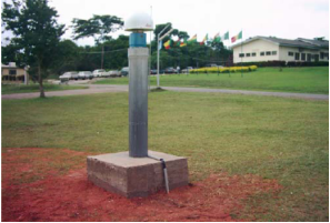 | Figure 2. First CORS station in Nigeria (Source: [20]) |
|
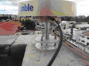 | Figure 3. Trimble R8- CORS at OSGOF roof top Abuja (Source: [22]) |
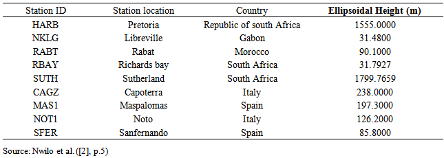
 | Figure 4. The Nigerian Permanent GNSS Reference Network (NIGNET) (Existing CORS stations) (Source: Adapted from Nwilo et al. [2]) |
3. Methods
3.1. Data Sources
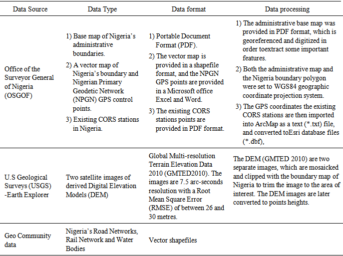
- The data used for this study are obtained from different secondary sources. A vector map of the Nigeria’s administrative boundary, Nigerian Primary Geodetic Network (NPGN) GPS control points as well as the existing CORS stations datasets are provided by the OSGOF. Other data sources include the U.S. Geological Surveys (USGS) Earth Explorer, Geo Community and Diva-GIS (see table 2 for more details).
|
3.2. Data Preparation and Analysis
3.2.1. Data Processing
- The processing of the collected data to map the existing CORS stations and the proposed sites for the establishment of new ones is summarised in table 2. From the table, the various data formats are standardised. This enables the integration of the various data sets into the research process. However, an interoperability issue was observed in the datasets, which are presented in both vector and raster formats, and most of them are in different referencing formats as they are acquired from different sources. As such, the files were converted to one projection system (World Geodetic System 1984 (WGS84)). The study used ESRI Arc GIS 10.1 software version to perform the analysis. This is because the software allows the exploration of the various data formats and has vast functionalities that suit the analysis conducted here.
3.2.2. Data Analysis
- The analysis commences by creating buffers of 100km radius from the existing 11 CORS stations in the country in order to observe their spatial coverage. This is because the study adopted the United States of America’s CORS map stations as a standard, bearing in mind the NGS’s guidelines for establishing new CORS stations which states that “proposed CORS will be no closer than 70km from an existing CORS” ([18], p. 5). This cannot be overlooked, as it is a requirement for establishing new CORS stations. The buffers established from the existing CORS stations are then converted to line features, and then to polygon features using ArcGIS 10.1 software, which allows the calculation of their spatial coverage in relation to the Nigerian area polygon.Satellite elevation imageor Digital Elevation Model (DEM) is used in proposing the location of the new stations because CORS, unlike its predecessor (Theodolites) in the field of surveying [13], are GPS instrument and do not use line of sight for baseline establishment (triangulation). Also, higher grounds have less obstruction of rarely more than 10 degrees above thehorizon [18].The DEM, which is a raster image, has been converted to points that allows for the determining of the height points and further classifications. The points are then classified according to the elevation difference. Care was observed during the classification in order to obtain a smooth and average spacing between the points. When selecting the proposed stations, it occurred that points lower than 100metres close to the riverside appeared in the valley (water bodies). Therefore, an effective measure was taken to move them further away from the water bodies by increasing the measurement of the height while avoiding random selection, as station stability is a priority. Also, the majority of the points are selected according to their proximity to public facilities, such as road networks. This is because accessibility is one of the priority factors in any developmental project and one of the core objectives in the guidelines for establishing bench marks and CORS stations ([18] & [22]). However, the stationing of some of the points on low land areas is to regulate the physical effect ofsoil characteristics. For example, areas with coarse-soil are best siltation sites because fine-grained or clay soil are susceptible to variation in moisture content and susceptible to erosion [22]. These areas (coarse-soil) are also easier to be accessed for maintenance than the stations on highlands or hillcrests.
4. Results and Discussions
4.1. The Spatial Coverage of the Existing and Proposed CORS Stations in Nigeria
- As highlighted earlier, CORS are categorised in tiers and the Nigerian CORS are operated under Tier 1 stations. Therefore, this study used the NGS’s benchmark guidelines for creating CORS stations, which was promoted by the United States NGS ([18], P.6). Figure 5 shows the coverage of the existing 11 CORS stations in Nigeria at 100km buffer. From the figure, it can be observed that the existing 11 CORS stations based on the 100km buffer covers only a quarter of the country’s area (306,598km² covered and 605,131km² uncovered). This is relatively poor at this radius and it is clear that there is a requirement for an increase in the number of the CORS stations to enhance the spatial coverage and distribution of the stations in order to meet up with the global standard. Hence, the need for proposing more condensed networks in the country.
 | Figure 5. The spatial coverage of the existing CORS stations in Nigeria at 100km Buffer |
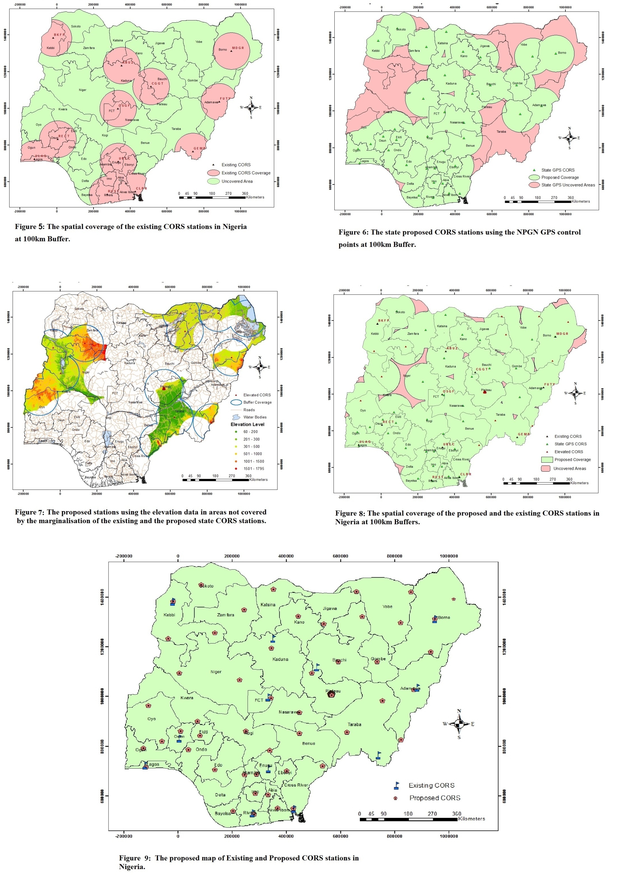 | Figure 6. The state proposed CORS stations using the NPGN GPS control points at 100km Buffer |
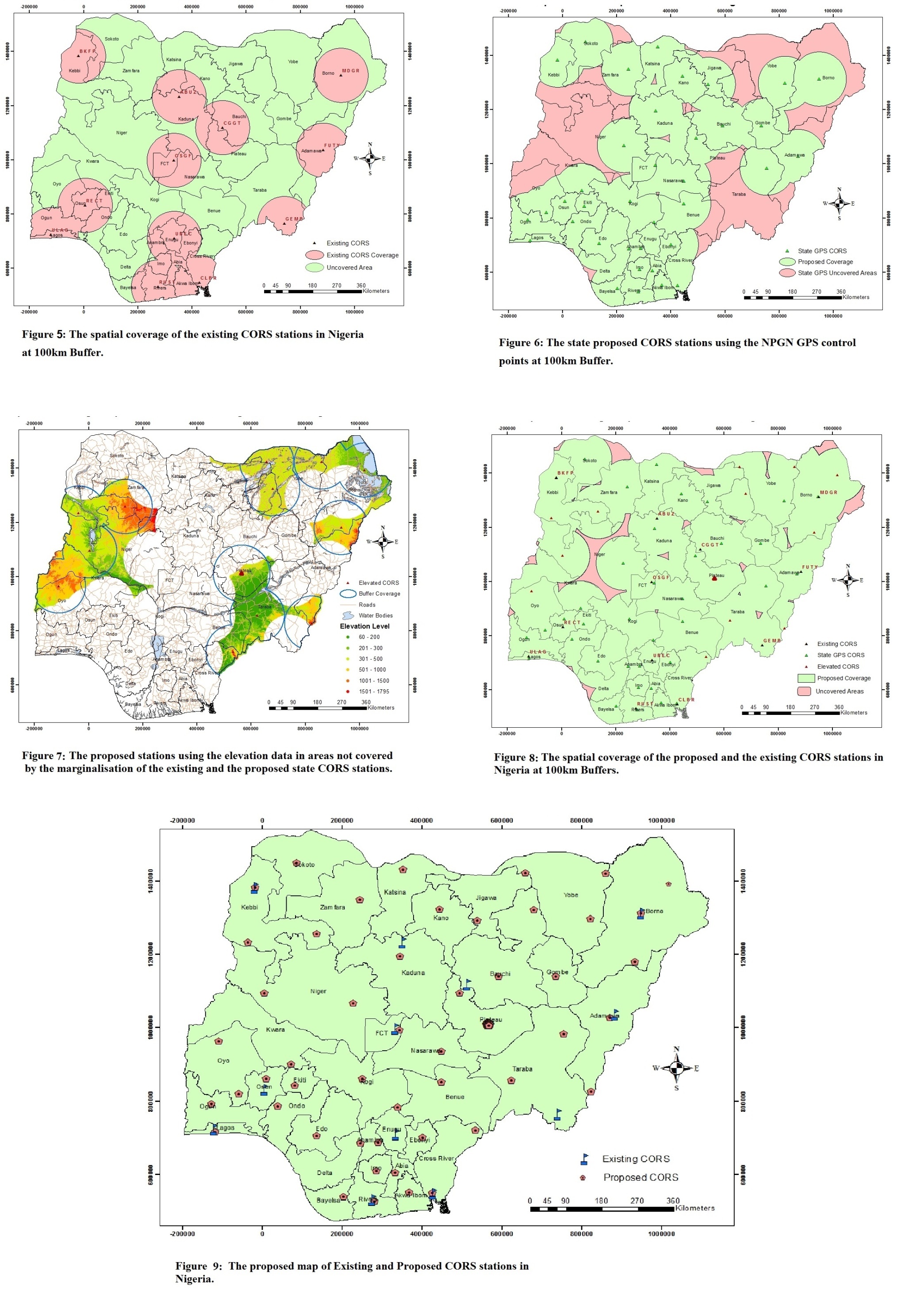 | Figure 7. The proposed stations using the elevation data in areas not covered by the marginalisation of the existing and the proposed state CORS stations |
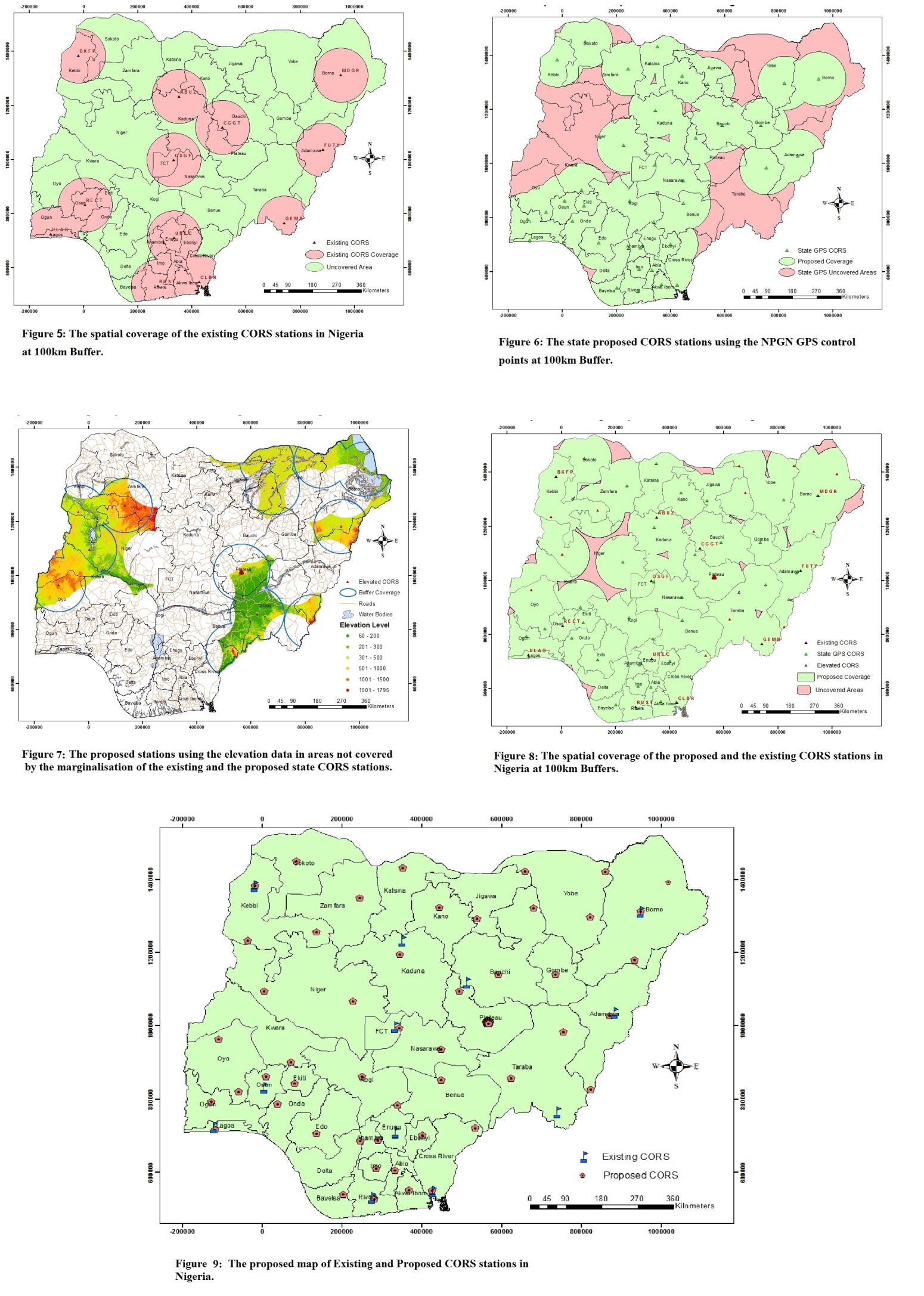 | Figure 8. The spatial coverage of the proposed and the existing CORS stations in Nigeria at 100km Buffers |
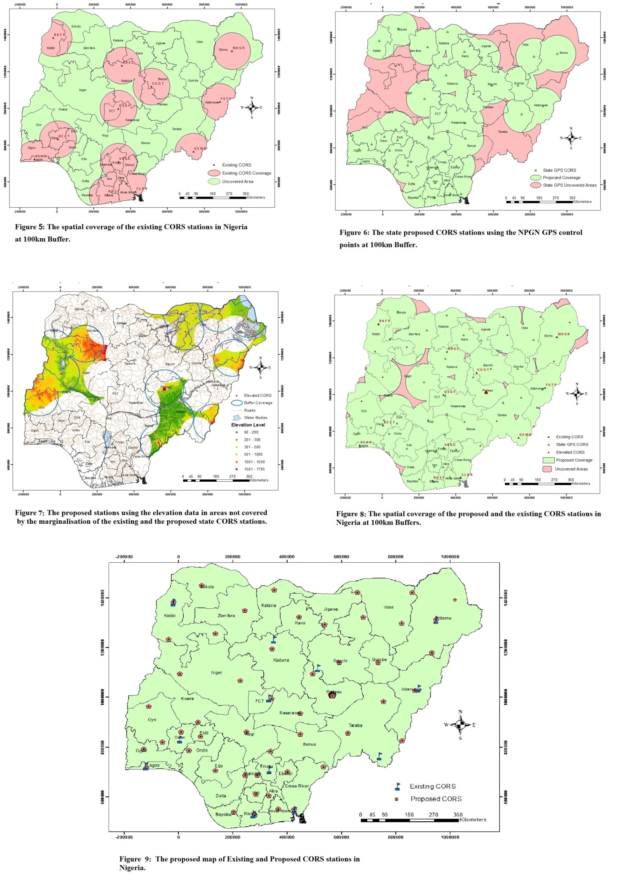 | Figure 9. The proposed map of Existing and Proposed CORS stations in Nigeria |
5. Conclusions
- Nigeria has already adopted the new geocentric datum, which commenced in 2007/2008 by installing CORS networks across the nation. This study used the international standard criteria for CORS establishment, as well as the objectives of the ITRF, AFREF and OSGOF to propose a condensed and more robust spatial network of CORS stations in Nigeria with baselines shorter than the existing 300km apart. However, the data sets used for the study are obtained from secondary sources and are only verified using other means such as the Google earth. Even though, the new proposed CORS stations maps are unable to provide any further detailed information about the landscape at each of the proposed stations due to the large area coverage and insufficient data, the study has highlighted the steps and potentiality of improving the existing CORS coverage map of the country. Therefore, the study serves as a template for future applications and fields that requires spatial coverage for their research or commercial use such as geospatial institutions and communication institutions.It should be noted that the study only focussed on spatial coverage, which limits other aspects of establishing CORS stations such as equipment specifications, data and communication procedures to be considered in this study. Also, there are many practical aspects of site configuration (for example, site monumentation, obstructions etc.) ([10], p.4& [18], p.7) that are considered during the establishment of CORS stations that this study overlooked because of lack of data.So far, it is evident from the results that the spatial coverage of the existing 11 CORS stations in Nigeria is inadequate, and therefore the proposal for the establishment of new ones is paramount. The new proposed 49 and the 11 existing CORS stations (totalling 60 CORS stations) established here covered about 96% of the total area of Nigeria as compared to the 11 existing stations that covers only 25% of the country. Also, the proposed stations have baseline distance of less than 200km apart, which provides a denser and well-improved distribution of networks. The proposed CORS networks can be linked to other existing CORS network within and outside the country, which can help reduce baseline dependent errors, improve positioning services and continuous referencing of GNSS measurements to the reference frame and datum, which is the sole objective of ITRF (see for example, [12] & [23]). It will also provide a common reference frame across the country and other continents for optimal collection, storage, exchanging and visualisation of information [12]. Similarly, the availability of well distributed CORS stations in Nigeria will make it possible to understand, expand and answer relative GNSS and GPS questions since it is the common standard technology in Navigation. This study opined that updating the current CORS stations in the country would accelerate the evolvement of the Nigerian terrestrial reference system into a complete NIGNET of 60 stations, which would potentially strengthen the Nigerian Primary Geodetic Network (NPGN).Overall, achieving a wider spatial coverage of the CORS networks (at near regular intervals), particularly now that the government is advocating for new reforms on infrastructural development across the nation is paramount.
ACKNOWLEDGEMENTS
- The authors wish to thank the OSGOF, the U.S. Geological Surveys (USGS), Geo Community and Diva-GIS for the data used in this study. We also like to thank the reviewers for their useful comments and suggestions.
 Abstract
 Reference
 Full-Text PDF
 Full-text HTML