Ikusemoran Mayomi1, Kolawole M. S.2, Adegoke Kayode Martins3
1remote Sensing & Gis Unit, Department of Geography, University of Maiduguri, Nigeria
2Geology Unit, Department of Earth Sciences, Kogi State University, Anyigba, Nigeria
3Department of Survey and Geomatics, Federal Polytechnic, Mubi, Nigeria
Correspondence to: Ikusemoran Mayomi, remote Sensing & Gis Unit, Department of Geography, University of Maiduguri, Nigeria.
| Email: |  |
Copyright © 2014 Scientific & Academic Publishing. All Rights Reserved.
Abstract
Following the location of large parts of Niger State in low terrain and proximity to River Niger: the largest river in Nigeria; coupled with the presence of three hydro Electric power stations in the state, Niger State has been confronted annually by flood disaster that has destroyed many lives and properties. The focus of this paper is the application of remotely sensed data and GIS techniques for terrain analysis for flood disaster vulnerability assessment of Niger State. Digital Elevation Modeling (DEM) of the State was created and classified into four: Niger valley, plains, uplands and highlands area using ArcGIS 9.3 software. It was revealed that the Niger valley and the plain terrain of the state which are classified as “highly vulnerable” and “vulnerable” respectively to flood disaster collectively cover a land area of 58.43% of the state total land area. Moreover, Katcha, Gbako, Bida, Agaei, Wushishi, Mokwa, Edati and Lapai were discovered to have their land area almost completely located in the Niger valley that is highly vulnerable to flood, while Agwara, Borgu, Bosso, Lavun, Magama and Mashegu have large portions of their lands located in the plains which were considered as vulnerable to flood. Shiroro Wushishi, Bida, Lavun and Gbako LGAs were also found to be vulnerable to flood disaster because of their locations at the downstream of Shiroro dam along River Kaduna. Some communities located at the downstream of Kainji, Jebba and Shiroro dams were also assessed for flood vulnerability through the assessment of the spatial locations of each of the communities within some specific buffer zones assed by spatial analysis of a generated database. It was recommended that remotely sensed data and GIS techniques should be adopted in creating data banks and generation of master plan for flood disaster in the state. Relocation of the communities in highly flood prone areas and pubic enlightenment on adherence to early flood warning were also recommended.
Keywords:
DEM, Flood disaster, Floodplains, GIS, Terrain analysis
Cite this paper: Ikusemoran Mayomi, Kolawole M. S., Adegoke Kayode Martins, Terrain Analysis for Flood Disaster Vulnerability Assessment: A Case Study of Niger State, Nigeria, American Journal of Geographic Information System, Vol. 3 No. 3, 2014, pp. 122-134. doi: 10.5923/j.ajgis.20140303.02.
1. Introduction
Niger state, no doubt was created to bring the government nearer to the people and to meet the yearnings of the people for common entity. However, since 1976 when the state was created, flood disaster has been an annual environmental hazard confronting the state [1]. The vulnerability of the state to flood disaster could be attributed to two major factors, the first being the location of large parts of the state in a lower terrain (Niger valleys and Plains) along the largest river in Nigeria, that is, River Niger, making the land and communities that are located in this low terrain area be prone to annual flooding. The second factor is the presence of the three Hydro Electric Power (HEP) stations in the state; the Kainji dam and Jebba dam on River Niger at Kainji and Jebba towns respectively and the Shiroro dam on River Kaduna. From the study of [2] the downstream of these three dams are vulnerable to floods especially when the spillways are opened to reduce water volumes in the dam so as to avoid dam collapse According to [3], historically, Nigerian floodplains have always attracted settlements especially in the northern part of Nigeria where the population is mostly agrarian. Those involved in the fishing sector of the agrarian industry normally settle along river banks and tributaries which are naturally flood prone. Also due to desertification, the segment of the population involved in livestock rearing necessarily have to live along river banks so that they can find enough water for their flocks. He stressed that the strongest attraction factor to settlements along flood plains especially in Nigeria is peoples’ strong affinity to flood plains in a claimed reverence to their ancestral heritage as this emotional attachment to ancestral areas of habitation is fueled by the cultural/religious attachment to ancestors, deities and sacred places including sacred lands. For instance, [4] noted that in Gbako LGA of Niger State, most of the communities that needed resettlements did not want to abandon their ancestral homes for other permanent places. According to [5] the obvious reason for flooding especially in municipalities and coastal areas in Nigeria lies in the wide distribution of low-lying coastal areas and river floodplains and because these areas have fast become a long standing attraction for human settlement, which [6] concluded that this subsistence attraction has become a high risk factor in most part of Nigerian floodplain regions. On the causes and impacts of flood hazards, [6] asserted that flood hazards are natural phenomenon, but the damages and losses from floods are the consequences of human actions because it has been known that floods can be caused by anthropogenic activities and human interventions in the natural processes such as increase in settlement areas, population growth and economic assets over low-lying plains prone to flooding which may lead to alterations in the natural drainage and river basin patterns, deforestation and climate change.Following the annual increase of flood disaster especially the devastating 2012 flood hazards in Nigeria coupled with improvement in the use of modern technologies for environmental monitoring such as remote sensing and GIS, the government of Nigeria and the relevant agencies have recently put all hands on deck for environmental monitoring and management especially flood disaster [7, 6] Flood disaster monitoring and management involves several processes and data generation, the terrain has to be studied, the landuse and vegetation cover deeply assessed, while the impact of the drainage and the hydrology of such areas must also be analyzed. Comprehensive data on all these activities and many more others have to be generated not only in good time with less cost but must also be very reliable with minimal human interference. [6] reported that there are number of tested techniques that could be used singly or in combination to map flood hazards and risks; which include historical information on floods, soil maps, aerial photographs, hydrological modeling of the major rivers, use of national digital terrain model and water level and satellite imageries. They concluded that geospatial technologies have been effectively used globally in respects of flood and water logging disaster monitoring and evaluation, water resources and water environment investigation. Several studies have been carried out by different authors on the use of geospatial techniques for flood assessment in the floodplains of Nigeria. For instance [8] used GIS and cellular framework approach for flood modeling and vulnerability of the floodplains of Adamawa State [7] used GIS based techniques to investigate flood vulnerability of the floodplains of the Benue basin, [6] applied geospatial techniques to the mapping and analysis of the 2012 flood disaster in the central parts of Nigeria. While [2] assessed flood vulnerability of River Kaduna downstream of the Shiroro dam using remote sensing and GIS techniques. In this study, a combination of remotely sensed data and GIS techniques was adopted to the analysis of the terrain of Niger State for flood vulnerability assessment. The use of SRTM data has recently become a pillar for terrain analysis, map referencing and accuracy assessment as well as for the study of vegetation cover, tsunami and geomorphology. For instance, [9] reported that since SRTM data became widely available, many studies utilized them for applications in topography (Falorni et al., 2005; Koch & Lohmann, 2000), geomorphology (Guth, 2003; Stock et al., 2002), vegetation cover studies (Kellndorfer et al., 2004), tsunami assessment (Blumberg et al., 2005), and urban studies (Gamba et al., 2002). SRTM data verification was performed using various altimetry data (Helm et al., 2002; Sun et al., 2003) and digital elevation models (Jarvis et al., 2004; Muller, 2005; Smith & Sandwell, 2003). On the importance of SRTM data, [9] reported that it is the first set of continuos data covering most part of the earth’s surface, it overcomes the deficiencies of conventional maps that have a variety of scales and levels of precision around the world, as well as overcoming the problems associated with ellipsoid and coordinate systems and the problems that occur at natural boundaries and even the general lack of data. Therefore in this paper, SRTM data was used to analyze the terrain of Niger state, Nigeria for flood vulnerability assessment.
1.1. Aim and Objectives
The aim of this study is to analyze the terrain of Niger State in order to assess the vulnerability of the land and the communities to flood disaster. The main objectives include:(i) To generate, classify and assess the quantity (in km2) of the classes of the terrain that are vulnerable to flood disaster in each LGA of Niger State (ii) To assess the vulnerability of some selected communities downstream of Kainji and Jebba dams along River Niger, and Shiroro dam along River Kaduna (iii) To create database on flood vulnerability of some communities and demonstrate spatial analysis of such communities to flood vulnerability
2. The Study Area
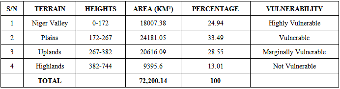
Though Niger State was created in 1976, but in 1991, the then Borgu LGA of Kwara State was merged with the present Niger State making the state to become the second largest state in terms of area landmass (72,200.14km2) after Borno State (74.83km2). Niger State shares international boundary with the Republic of Benin in the west and also shares state boundaries with Kebbi and Zamfara states in the north, Kaduna and FCT in the east, and Kogi and Kwara in the south. Niger state is located between latitudes 8.02◦N and 10.20◦N and longitudes 3.38◦E and 7.03◦E (Fig. 1). The 2006 National Population and Housing Census [10] put the total population of the state as 3, 954,772. Niger State with a total land area of 72,200.14km2 has the Niger valley terrain covering 18,007.38km2 (24.94%), the plains covering 24,181.04km2 (33.49%), upland covering 20616.09 (28.55%) while the remaining 9593.3km2 (13.01%) are made up of highlands (Table 1). The climate, vegetation and the soil of Niger State as described by [11], reported that the state experiences two distinct seasons the dry and wet seasons. The annual rainfall varies from about 1,600mm in the south to 1,200mm in the north. The duration of the rainy season ranges from 150 to 210 days or more from the north to the south. Mean maximum temperature remains high throughout the year; however, the lowest minimum temperatures occur usually between December and January when most parts of the state come under the influence of the tropical continental air mass which blows from the north. The Southern Guinea Savannah vegetation covers the entire landscape of the state. Like in other states of similar vegetation, it is characterized by woodlands and tall grasses interspersed with tall dense species. Three major soils types can be found in the State. These include the ferruginous tropical soils, hydromorphic soils and ferrosols. The most predominant soil type is the ferruginous tropical soils which are basically derived from the Basement Complex rocks, as well as from old sedimentary rocks. Such ferruginous tropical soils are ideal for the cultivation of guinea corn, maize, millet and groundnut. Hydromorphic or waterlogged soils are largely found in the extensive flood plain of the Niger River. Ferosols which developed on sandstone formations can be found within the Niger trough.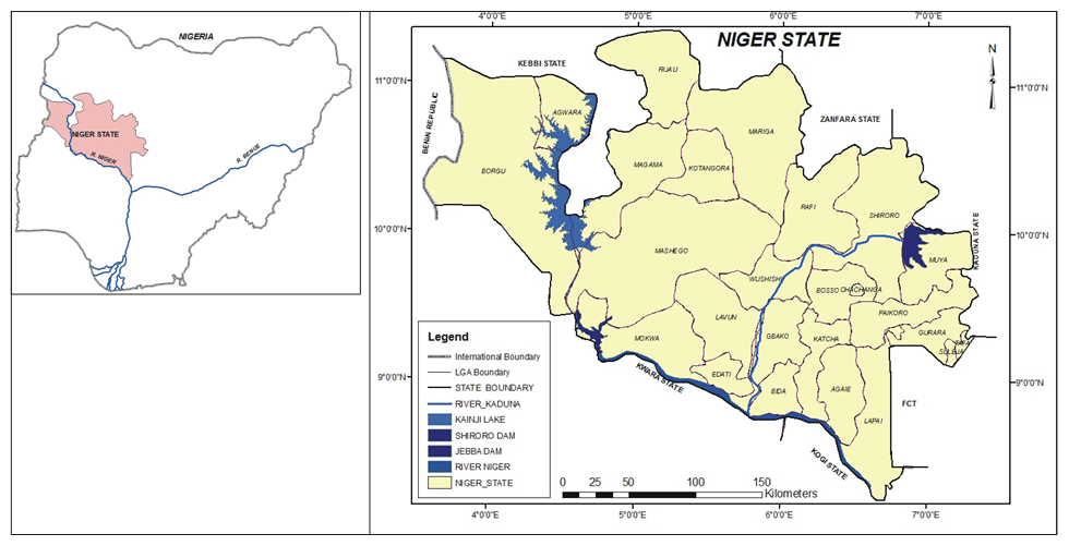 | Figure 1. The Study Area |
Table 1. Terrain Classes of Niger State
 |
| |
|
3. Materials and Methods
3.1. Materials
The materials that were acquired for this study include:(i) Digital Elevation Dataset from Shuttle Radar Topographical Mission (SRTM).(ii) Germin 72 Global Positioning System for acquisition of spatial locations of some communities in Niger State(iii) Thematic map of Niger State(iv) The 2006 Population and Housing Census Data(v) ArcGIS 9.3 and CorelDraw 12 software
3.2. Methods
3.2.1. Generation and Classifications of Digital Elevation Models (DEM) of Niger State
Since the study dwells much on terrain analysis, the terrain of the state was achieved through the generation of DEM images of the state. In this study, the DEM creation module of ArcGIS 9.3 was used to create the DEM of Niger State from Digital Elevation Dataset of Shuttle Radar Topographical Mission (SRTM). According to [9, 12] the shuttle Endeavour conducted the SRTM from an eleven day flight in February, 2000 which generated topography data between latitudes 56°N and 60°S. This SRTM data are of two types: the one arc second popularly known as SRTM1 which is mainly for USA and the three arc seconds known as SRTM3 for the rest of the world (11). Therefore the SRTM3 which has a spatial resolution of 90m was used in this study. The acquired dataset was vectorized using the raster polygon module of ArcGIS, while the output polygon map was classified into four major classes of: (i) Niger valley/basin which are found along River Niger with heights between 0 and 172m above the sea level (Fig. 2) and was classified as “highly vulnerable” to flood(ii) The plain with heights ranging from 172-267m (Fig. 2) above sea level which was classified as “vulnerable” to flood.(iii) The upland areas with a range of 267-382m above sea level (Fig. 2) was classified as “marginally vulnerable”(iv) The highland areas with their heights between 383 and 744m (the highest point in the state) above sea level as “not vulnerable” (Fig. 2).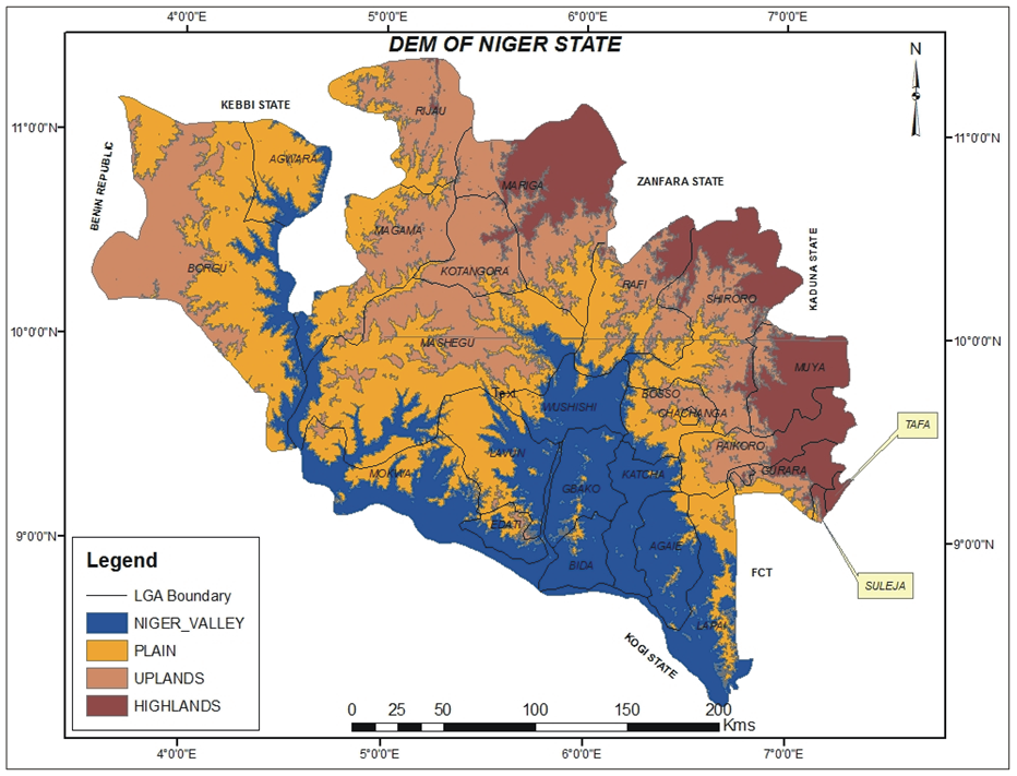 | Figure 2. DEM of Niger State |
3.3. Creation of Buffer Zones along the Two Main Rivers in the State
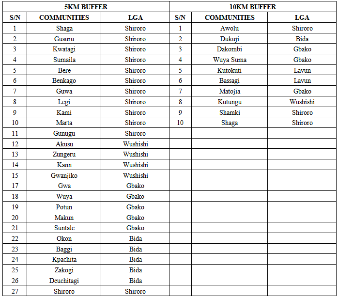
Previous flood experiences along River Niger [13, 14] revealed that during normal flood, an average of five kilometers at both sides of the river is affected. However, during excessive floods when the spillways of the dams are opened, an average of 10 kilometers of land at both sides of the river is affected. Meanwhile 5km and 3km buffer are said to be flooded on River Kaduna during normal flooding periods and when the spillway of Shiroro dam is opened respectively [2]. It is against this information that buffer zones of 5 and 10 kilometers were generated on river Niger at the downstream of the dams and 3 and 5 kilometers buffer on River Kaduna at the downstream of Shiroro dam using the multiple buffer module of ArcGIS software. It must however be noted here that considering the general terrain of the valleys of Rivers Niger and Kaduna (Fig.6), major parts of the valleys are located on either the Niger Basin or the plains with little areas especially the valley of River Kaduna close to Shiroro dam that are located in uplands. Therefore, since the heights of both the Niger basin and the plains are less than 267m, such topography are expected to be vulnerable to serious floods with little or no differences if the altitudes of the places are put into considerations. The little parts that are on the upland areas close to Shiroro dam may also be seriously affected by floods at both sides due to the large volume of water that are released from the dam especially when the spillways are opened, hence an altitude of less than 382m may not necessarily be a serious barrier. Hence, the use of equal meters for buffering both sides of the rivers.
3.4. Linking of Some Communities to the DEM and the Buffer Zone Maps
Germin 72 Global Positioning System (GPS) was used to acquire the coordinates of some selected communities in order to link the communities to the appropriate positions in the state. The communities that were linked to the map were selected in the following ways:(i) 30 communities were selected from those that are located at the downstream of Kainji and Jebba dams on River Niger. The selection of the communities were not based on particular numbers from each LGA or terrain types but based on all the communities that were identified and accessed. The specific locations of all the communities were derived by using GPS to obtain the coordinates of each of the locations of the 30 selected communities which were linked to the map through the “add xy data” module of ArcGIS. The essence of this procedure was to be able to identify the communities that lie in each of the two buffer zones of 10 and 5km. The select by attribute module of ArcGIS was then used to identify and generate the information in Fig 5 and Table 3 (ii) 37 communities were also selected from the numerous communities along the valleys of River Kaduna downstream of Shiroro dam using the same processes in 3.3i. The information in Table 4 were derived from this step(iii) In order to have clear assessments of the actual locations of each of the communities in the classified DEM map, that is, to know where among the four classified DEM of River valley, plains, uplands and highlands a community is located, all the communities in the state are linked to the DEM map. However, considering the cost and time of obtaining the coordinates of all the settlements in the State, Lavun LGA was selected using random sampling technique. The coordinates of 21 communities were obtained in the LGA using the same procedure in 3.3i to generate the information in Fig.3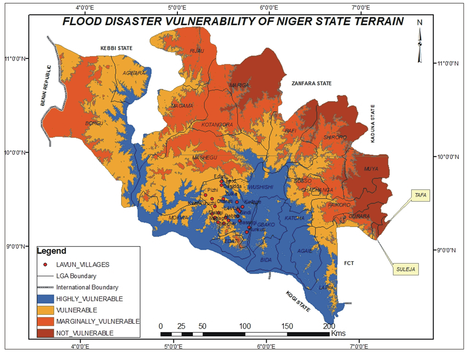 | Figure 3. Flood disaster vulnerability of the terrain of Niger State |
3.5. Identifications of the LGAs and the Communities that are Vulnerable to Flood
On the generated DEM and the buffer maps and with the superimposition of LGA boundary lines on the DEM map, the following criteria were used to classify flood vulnerability of each of the LGAs in the state:(i) All the LGAs that are located in the River Niger valley terrain. The eight LGAs in this category as revealed in Table 2 include: Katcha (95.97%), Gbako (95.22%), Bida (93.25%), Agaie ((0.06%), Wushishi (83.23%), Edati (64.09%) and Lapai (62.98%). (ii) All the LGAs that are located in the plain terrain. The LGAs in this category include: Agwara (99.7%), Lavun (98.52%), Chanchaga (75.58%), Mashegu (70.46%), Bosso (68.71%), Borgu 61.42%) and Magama (52.21%)(iii) All the LGAs that are located in the downstream of the three HEP dams in the state, that is, Mashegu in the downstream of Kainji dam, Mokwa, Bida, Katcha, Agaie and Lapai LGAs in the downstream of Kainji and Jebba dams and Shiroro, Rafi, Wushishi, Lavun, Gbako, Edati and Bida at the downstream of Shiroro dam.(iv) All the communities within 5 and 3 kilometers buffer along the valleys of River Niger and River Kaduna respectively are expected to be more prone to floods than those within 10 and 5 kilometers on Rivers Niger and Kaduna respectively
3.6. Flood Vulnerability Mapping
Flood vulnerability map was generated from the generated DEM map, the buffer maps and the locations of the communities. Flood vulnerability of the terrain and the communities based on their locations was classified into the following:(i) Highly vulnerable: All the land and communities within the 5 and 3 buffer zone on Niger and Kaduna rivers respectively and those located within the Niger valley of the terrain.(ii) Vulnerable: All the land and communities located in the plains as well as those within 10 and 5 kilometers buffer along Rivers Niger and Kaduna respectively.(iii) Marginally vulnerable: All the land and communities located in the Upland areas of the terrain(iv) Not vulnerable: All the land and communities located in the highland areas.
3.7. Development of Geo-database and Spatial Query for Decision Making
Database of the selected communities that are located along Rivers Niger and Kaduna as well as those that are found in the sampled LGA, that is, Lavun LGA were generated. The database was subsequently queried in order to generate some information that could be used for decision making. For instance, the by attribute module of ArcGIS was used to select in a single map all the communities that meet the following conditions: all the communities located within 5km buffer along River Niger, all the communities located within 5km buffer along River Kaduna and finally, all the communities located in Niger valley of the terrain of the State. The output map is presented in Fig 6.
4. Discussion of Results
4.1. Analysis of the Terrain of Niger State for Flood Vulnerability
The coverage and vulnerability of each classes of the terrain, that is, the Niger valley, the plains, the uplands and the highland areas as generated in Fig 2, is presented in Table 1.Table 1 revealed that plain terrain cover larger area (33%) than the other terrain types in Niger State. However, more than half (58.43%) of the land area of Niger State are located in either Niger valley or plains which are classified as “highly vulnerable” and “vulnerable” to flood disaster respectively (Fig 2). Therefore, the terrain of Niger state has made it prone to floods and its associated hazards as reported by [4] that though the Niger valley and the plains of Niger State may aggravate flood disaster occurrence, research has revealed that such areas are also beneficiary for agricultural development. For instance, [11] reported that Niger State contains extensive flood plains of the River Niger and this has made the state to be one of the largest and most fertile agricultural lands in the country. It also provides the best area for rice growing in Nigeria. Perhaps this may account for the location of the National Cereals Research Institute at Badeggi in the State.Having known the general impact of the terrain on flood disaster vulnerability in the State, efforts were also made to analyze the terrain of each of the twenty five LGAs in the State for assessments of their vulnerability to flood. The results are presented in Table 2 which revealed that in terms of the terrain, the following LGAs are “highly vulnerable” to flood disaster: Katcha, Gbako, Bida, Agaei, Wushishi, Mokwa, Edati and Lapai. While Agwara, Borgu, Bosso, Lavun, Magama and Mashegu are considered to be “vulnerable”. The remaining LGAs can be said to be free from flood occurrence if only the terrain factor is put into consideration. Previous reports on flood disaster occurrence in Niger State have proved the vulnerability of these LGAs to flood disaster. For instance, [15] reported that according to the Director General, Niger State Emergency Management Agency, Alhaji Mohammed Shaba, 10 out of the 25 LGAs of the state were affected by the 2012 flood: the 10 LGAs are, Mokwa, Lavun, Edati, Chanchaga, Shiroro, Borgu, Bida, Bosso, Munya and Wushishi. Moreover, [4] reported that the Gbako Local Government Area of Niger State commenced the arrangements to relocate over 40 communities that are prone to flood disaster as over 45 per cent of the land mass of the council was prone to flood because of the topography of most of the communities. While [16] reported that thirty communities in Lapai LGAs of Niger state have called on the state government to immediately resettle them out of the plains of River Niger following the menace of annual floods that have continued to ravage the area.
4.2. Assessment of the Communities and the Terrain to Flood Vulnerability
If a vast land area is flooded without any negative impact on human lives and properties, such area may just be regarded as being “flooded” without seeing it as a ‘disaster”. Therefore having classified the terrain of the state into vulnerability classes, it is necessary to identify the communities in each of the terrain classes so as to assess the vulnerability of the communities to flood disaster. Therefore, since it involves much time, energy and capital to generate the actual locations of all the communities in the state for flood vulnerability assessment, the coordinates of twenty one communities were generated in Lavun LGA which is the sampled LGA. The positions of each of the communities were seen on the terrain map as presented in Fig 4. While only nine communities are located within the Niger valley terrain that is classified as “highly vulnerable”, the remaining twelve communities are located in the plain that has been classified as “vulnerable”. From this sample, it can be concluded that most of the communities in Lavun LGa are prone to floods as reported by [17] that Lavun LGA has been one of the LGAs that are flood ravened. Moreover, Fig.4 revealed that Pizhi community is located on a plain terrain which is safer than those communities in the Niger valley. Therefore, the aspirations of Pelle, Rigido, Eda and Gbami to be relocated to Puzhin are not surprising as Pizhi is located on a higher elevation (Fig.4). Therefore if the coordinates of all the communities in the state are generated and linked to the terrain image, one will be able to assess the vulnerability of any of the communities to flood disaster: Niger Valley: Kukunti, Bassagi, Debba, Gindi, Awodu Kinchi, Kudagi, Kitcha, Kutiwengi and Edun. Plains: Pizhi, kwankuruzhi, Nabagi, Tunga Munini, Muchiti, Dabiga, Betamegi, Jakudosu, Dukunchi, Charati, Zulka and Dagidda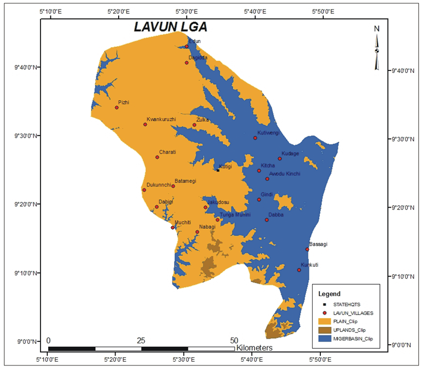 | Figure 4. Dem of Lavun LGA with locations of some communities |
4.3. Assessment of Flood Vulnerability of the Communities in the Downstream of Kainji, Jebba and Shiroro Dams
According to [6] because of the huge agricultural and natural resources potentials, the floodplains of the Niger has become a long standing attraction areas for human settlements and subsistence activities. Moreover the population map of Niger State based on the 2006 Population and Housing Census (Fig.5b) revealed that most of the LGAs with high and moderate number of people are either located along the Niger valley/plains or along the valleys of River Kaduna (Fig 5a).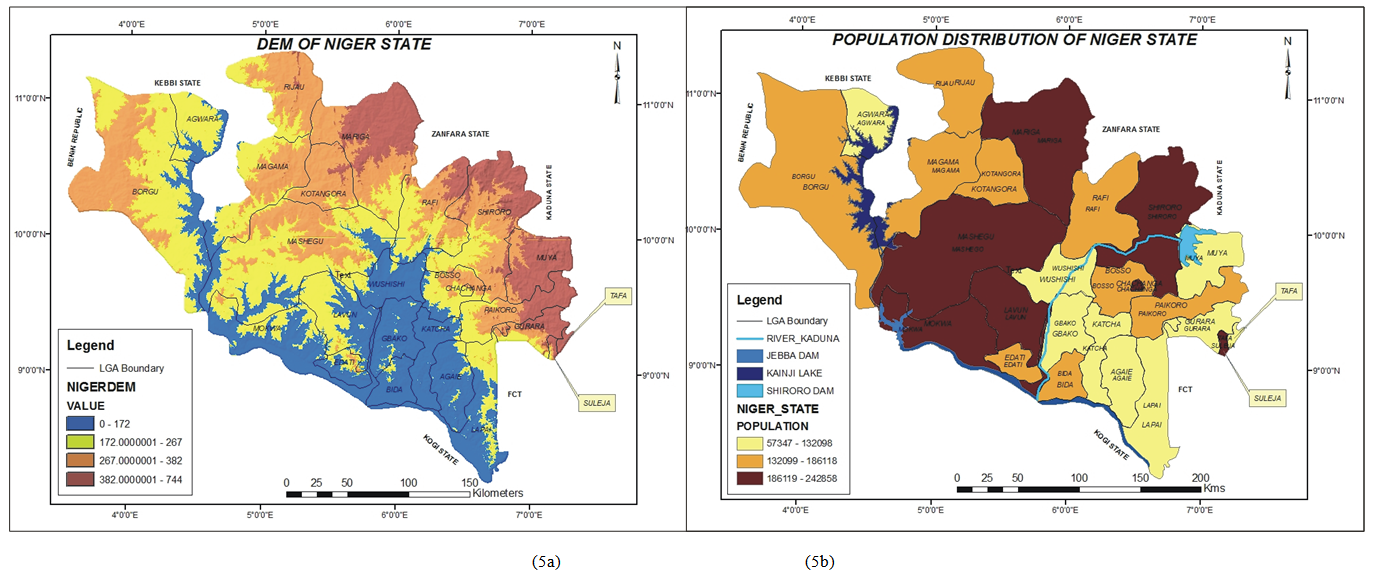 | Figure 5. (5a) DEM of Niger State; (5b) Population Distribution of Niger State |
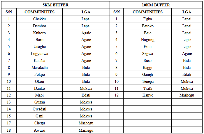
The necessity to assess the vulnerability of the communities in the floodplain of the Niger with high population has called for the assessments of flood disaster vulnerability of the communities in the downstream of the three major dams (Kainji, Jebba and Shiroro) in the State and the valleys of River Niger as shown in Fig. 6 In the River Niger basin, out of the thirty sampled communities, eighteen were discovered to be located within 5km buffer zone while twelve were within 10km buffer zone as presented in Table 3. Therefore, all the communities within the 5km zone are expected to be more vulnerable to flood disaster during the normal annual floods. For instance [18] reported that about 100 people have been displaced by flood water in old Awuru (one of the communities within 5kms buffer zone in Table 3) of Borgu Local Government Area of Niger State where the flood submerged about 38 houses, two mosques, farm lands and the only market in the community. Those communities within the 10kms zone are however only vulnerable when the spillways of the dams are opened during the annual floods when the lives and properties are in danger [13, 14]. Egba community which is one of the communities within 10kms buffer but further than 5kms buffer was reported [16] to be one of the 12 communities that were asking the government to resettle them to Kolo Legba Junction in Binna area of the state.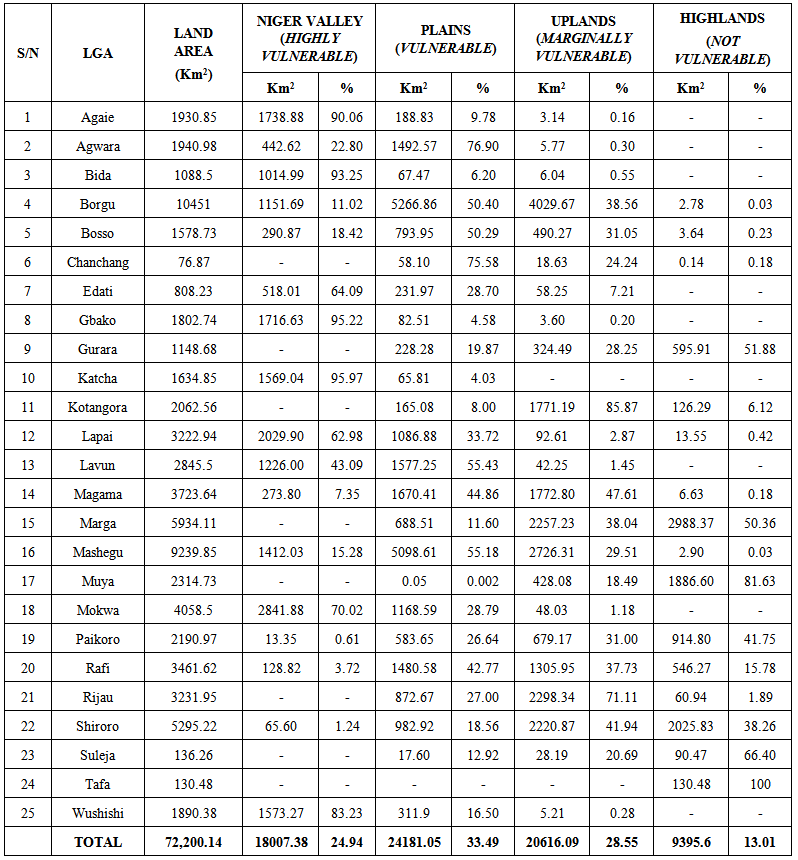 | Table 2. Flood vulnerability of the terrain in each LGAs of Niger State |
Table 3. Flood Vulnerability of the communities downstream of Kainji and Jebba dams
 |
| |
|
The vulnerability of some communities to flood in the downstream of Shiroro dam on River Kaduna is presented in Table 4 where twenty seven out of the thirty seven sample communities are located within 5kms buffer zone of R. Kaduna, while the remaining ten communities are further 5kms but within 10kms buffer zone.Table 4. Flood Vulnerability of the communities downstream of Shiroro dam
 |
| |
|
On the impacts of flood on the communities and land of the downstream of Shiroro dam along the valleys of River Kaduna, [3] commented that flood vulnerability of the dwellings downstream of Shiroro dam decreases with increasing distance from the river channel as evidenced from the 2012 flood disaster when dwellings nearer the river experienced more flood damages than those further off both sides of the river channel. He also reported that terrain elevation was another factor as houses whose terrain levels in relation to the river bed were higher did not also experience much flood damages even if they are close to the river bed. Therefore, Fig.6 revealed that right from the mouth of the Shiroro dam to the confluence of River Kaduna to River Niger, the terrain along the river channel is either plain or Niger valleys, hence making all the communities along river valley to be prone to flood disaster, though, depending on the distance from the river. Shiroro Town one of the communities within 5kms buffer along R. Kaduna has been rated as highly flood prone. For instance [3] reported that” the flood change in the Shiroro community is an ever present threat that will never go away” , though they concluded that better water way management and improved dam management will certainly reduce flood risk in Shiroro community. 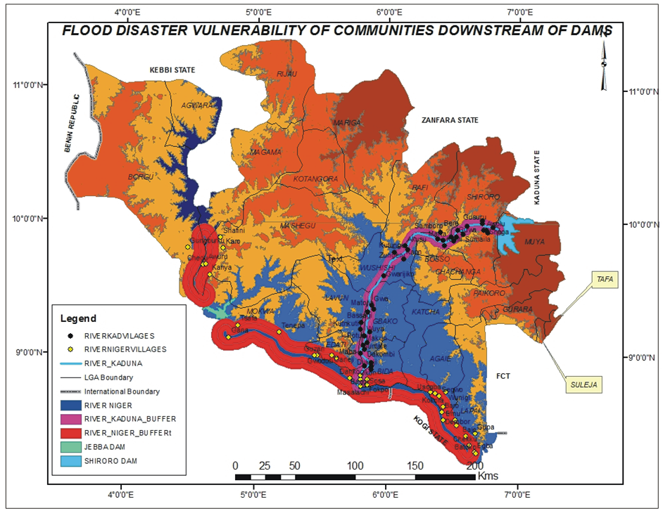 | Figure 6. Communities’ vulnerability to flood disaster in Niger State |
4.4. Spatial Analysis of Flood Vulnerability of the Land and Communities of Niger State
One of the capabilities of GIS techniques which distinguish it from other forms of spatial analysis is its ability to be spatially referenced. In this paper, a simple database was created using attribute data such as names of the communities, the coordinates of each of the communities, the terrain locations (Niger valley, plain, uplands and highlands) of each of the communities and the buffer zones locations (10, 5, and 3kms buffer) of each of the communities within the buffer zones. In this paper, the select by attribute module of ArcGIS was used to perform the following operations on a single map.(i) Identify and select all the settlements located within 5kms buffer among the sampled communities along River Niger(ii) Identify and select all the settlements located within 5kms buffer among the sampled communities along River Kaduna(iii) Identify and select all the settlements that are located in the Niger Valleys among the sampled communities in Lavun LGAThe result of the queries is presented in Fig. 7 (part of the map is zoomed in so as to clearly see the output map and the selected communities). The essence of this part of the study is to demonstrate quick generation and extractions of simple or complex information for decision making such as selection of all the communities that are highly vulnerable to flood disaster in the state, that is: those located in Niger valley in Lavun LGA, those within 5kms buffer along River Niger and those located within 3kms buffer along River Kaduna. The acquisition of these information may be very difficult, costly, time consuming, unreliable (prone to errors) and subject to human manipulations if manual methods are applied. Hence vital decisions like resettlements of some communities, flood monitoring and management and planning will surely be better achieved if remotely sensed data and GIS techniques are applied.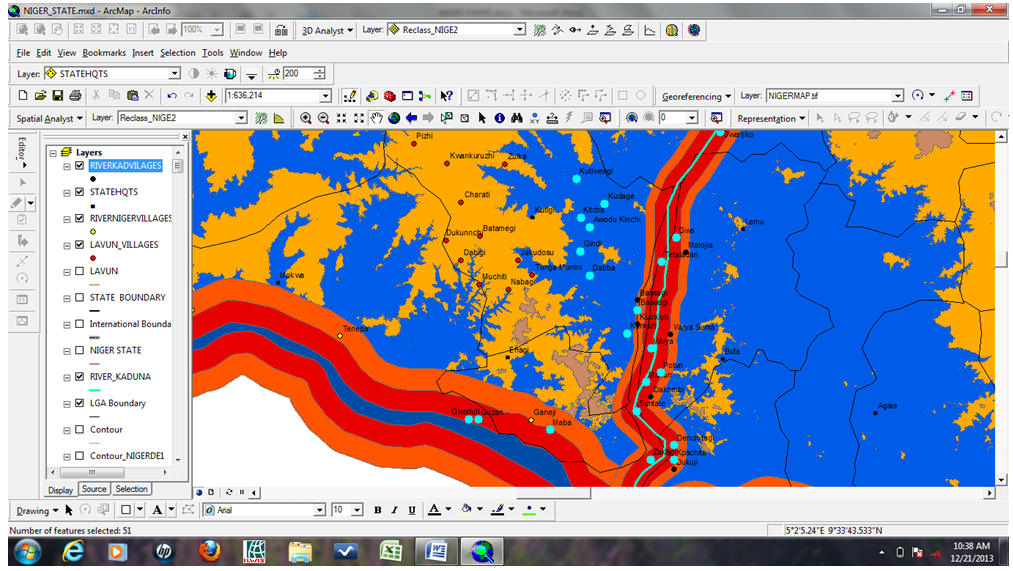 | Figure 7. Assessment of the communities in highly vulnerable terrain |
5. Summary and Conclusions
The use of remotely sensed data and GIS techniques for terrain analysis of Niger State in order to assess the flood disaster vulnerability of the state has been demonstrated in this paper. The study revealed that the terrain of Katcha, Gbako, Bida, Agaei, Wushishi, Mokwa, Edati and Lapai LGAs were highly vulnerability while Agwara, Borgu, Bosso, Lavun, Magama and Mashegu LGAs are considered to be “vulnerable”. Shiroro, and Wushishi LGAs which are though, not in highly vulnerable terrain but located at the downstream of Shiroro dam were also considered highly vulnerable to flood It has been reported that the basin of the River Niger which is suitable for the cultivation of various crops with all year available pastures for animal grazing especially during the dry season with no seasonal water scarcity for man and animals have made the river basin to be conducive for human habitation, hence, making the area to be more populated than the surrounding upland and highlands area. The annual floods induced by spill-water from dams across Rivers Niger and Kaduna along the Niger-Benue trough have threatened the existence of the inhabitants of this region for some decades, a situation that heightened the establishment of Hydroelectricity Power Producing Areas Development Commission (HPPPADEC). In order to effectively tackle the menace of flood disaster, there is the need for terrain analysis for proper landuse assessment and planning, the need for automated data gathering and analysis for generation of information that can reliably be depended upon for decision making on the estimation of Internally Displaced Persons (IDP), the communities to be resettled and where they would be resettled as well as compensation of persons and communities that are victims to flood. All these require quick, accurate, and cheap means of automated procedures which remotely sensed data and GIS techniques is second to none in spatially referenced data generation and analysis.
6. Recommendations
Based on the findings of this study, the following recommendations are made to effectively minimize the impacts of flood disaster in the State (i) Automated mapping and analysis of the terrain of the State so as to generate data bank and a kind of master plan for flood disaster monitoring and management in the state(ii) Generation of a comprehensive data and periodical reviews of all the communities that are vulnerable to flood in the state for quick decision making especially during flood disaster(iii) Relocation of all the communities that are discovered to be highly vulnerable to flood and discouragements of future settlements in flood prone areas(iv) Public enlightenments and awareness on flood early warning and disaster and disengagement from cultural affinity to flood prone areas which should be disseminated to the public in their own languages and through media that the majority of the people have access to(v) HPPADEC should as a matter of urgency address the myriad of perennial pains and hardship, born from the existence and activities of the three hydro-electricity dams of Kainji, Jebba and Shiroro
References
| [1] | Jubril Musa and Yunusa M.B. 2012. Using remote sensing data to improve rice production in Kutigi, Niger State, Nigeria. confluence journal of environmental studies, Vol. 7. Pp 66-71. |
| [2] | Muhammad Ismai’l and Iyortim Opeluwa Sannyol 2013. Application of remote sensing and GIS for flood vulnerability mapping: Case study of River Kaduna, Nigeria. International journal of geomatics and geosciences. Vol. 3 No. 3. |
| [3] | Anunobi, A. I. 2013. Housing vulnerability resilience and adaptation strategies to flood hazard. A case study of Shiroro Town in Niger State, north central Nigeria. Developing country studies. Vol. 3 No. 12 pp 73-81. |
| [4] | Opara, A. (2013) Niger State relocates 40 flood-prone villages. www.punchng.com. Retrieved Oct. 10 2013. |
| [5] | Ologunorisa, T. E and Abawua, M.J. 2005. Flood risk assessment: a review. Journal of applied sciences and environmental management. Vol. 9 No. 1 pp 57-63. |
| [6] | Ojigi, M.L., Abdulkadri, F.I., and Aderoju, M.O. 2013. Geospatial mapping and analysis of the 2012 flood disaster in central part of Nigeria. A Paper presented at the 8th National GIS symposium, Dammam, Saudi Arabia April 15-17 2013. |
| [7] | Ikusemoran Mayomi, Anthony Dami and Maryah, A.U. 2013. GIS based assessment of flood risk and vulnerability in the Benue floodplains, Adamawa State, Nigeria. Journal of geography and geology, Vol.5 No.4. pp 148-160. |
| [8] | Nwilo, Peter, C., Olayinka, Nihinlola. D., Ayila, D., Adzandar 2012. Flood modeling and vulnerability assessment of settlements in the floodplains using GIS and Cellular framework approach. Global journal of human social sciences, Vol. 12, Issue 3. |
| [9] | Liu, Y. (2000). An evaluation on the data quality of SRTM DEM of the Alpine and Plateau areas, North-Western of China. The international achieves of the photogrammetery, remote sensing and spatial information science. Vol xxxvii, part B1, Beijing pp 1123-1128. |
| [10] | National Population Commission 2009. 2006 Population and housing census of the federal republic of Nigeria: National and state population and housing priority tables. |
| [11] | Ayinde O.E., Ojehomon, V.E.T., Daramola, F.S and Falaki, A.A. 2013. Evaluation of the effects of climate change on rice production in Niger State Nigeria. Ethiopian Journal of environmental studies and management. Vol 6 PP 763-773 Volume 1. |
| [12] | Goncalves, J.A. and Morgado, A.M. (2008). Use of SRTM DEM as a georeferencing tool by elevation matching. The international achieves of the photogrammetery, remote sensing and spatial information science. Vol xxxvii, part B2, Beijing pp 879-884. |
| [13] | Ikusemoran, Mayomi 2000. Remote sensing and GIS for flood surveillance: A case study of Kainji lake basin, New Bussa, Nigeria. An unpublished M,Tech thesis, Department of Geography, Federal University of Technology, Minna. |
| [14] | Okhimanhe, Appollonia 2010. Satellite based assessment of natural and human induced environmental change in lake ecosystems: The case of Kainji Lake in Nigeria. Paper presented at the 2nd regional workshop on decision making support for coastal zone management, water resources and climate change in Africa, held between 15th and 17th Feb. 2010 at the International conference center, Cotonou, Republic of Benin. |
| [15] | Wakasso Aisha 2013. Seven killed, 149 Communities sacked by flash flood in Niger. www.thisdaylive.com. Retrieved Oct. 10 2013. |
| [16] | Ojo Aideloja 2013. Floods: 30 communities seek resettlement in Niger State.blueprintng.com/.../floods-30-communities-seek-resettlement-in-niger. Retreived Oct. 10 2013. |
| [17] | Niger State Environmental Protection Agency 2013. Flood: NSEMA begins resettlement of 10 communities. NSEPA 2013 Report. |
| [18] | Pita Chikwem 2013. Niger relocates 40 flood-prone villages. www.punchng.com. Retrieved Oct. 10 2013. |
 Abstract
 Reference
 Full-Text PDF
 Full-text HTML