-
Paper Information
- Paper Submission
-
Journal Information
- About This Journal
- Editorial Board
- Current Issue
- Archive
- Author Guidelines
- Contact Us
American Journal of Geographic Information System
p-ISSN: 2163-1131 e-ISSN: 2163-114X
2014; 3(2): 88-97
doi:10.5923/j.ajgis.20140302.03
Surveying and Mapping in Sustainable Land Administration and Socioeconomic Development in Nigeria: An Overview
 Abstract
 Reference
 Full-Text PDF
 Full-text HTML
Opaluwa Y. D 1, Adejare Q. A 2, Samaila-Ija H. A 1, Onuigbo I. C 1, Nwose I. A 1, Idris M. K 3
1Department of Surveying and Geoinformatics, Federal University of Technology Minna, Nigeria
2Seidel Geospatial Technology Ltd, 8, Ikosi Road, Ketu Lagos, Nigeria
3Department of Surveying and Geoinformatics, Niger State Polytechnic, Zungeru, Nigeria
Correspondence to: Opaluwa Y. D , Department of Surveying and Geoinformatics, Federal University of Technology Minna, Nigeria.
| Email: |  |
Copyright © 2014 Scientific & Academic Publishing. All Rights Reserved.
Land as a resource is fixed in supply but its demand for various uses is variable and on the increase as human population keeps on increasing. This explains why efficient land administration is central to socio-economic development of any nation. This paper presents an overview of Surveying and Mapping in sustainable land administration systems vis-à-vis its relevance in socio-economic development of Nigeria. Therefore, a comprehensive discussion of the concept of land administration systems was attempted, in view of this; a prototype land information system was developed. The engineering and scientific applications of surveying and mapping in solving both human and socio-economic problems were identified. In conclusion, the paper stressed the need to accord surveying the rightful place and priority in the national development programme.
Keywords: Land information System, Sustainable development, Surveying and Mapping, Land administration
Cite this paper: Opaluwa Y. D , Adejare Q. A , Samaila-Ija H. A , Onuigbo I. C , Nwose I. A , Idris M. K , Surveying and Mapping in Sustainable Land Administration and Socioeconomic Development in Nigeria: An Overview, American Journal of Geographic Information System, Vol. 3 No. 2, 2014, pp. 88-97. doi: 10.5923/j.ajgis.20140302.03.
Article Outline
1. Introduction
- The basic theoretical framework for all land administration systems in the world over is the delivery of sustainable development; this forms the bottom line for: economic, social and environmental development, as well as good governance. This in no doubt is the basic philosophy of the transformation agenda of the present administration. However, efficient socio-economic development and good governance required judicious planning, design and implementation, as well as rational use of land and its resources [12]. Hence, the need for maps and map substitutes is indispensable in this regards. Furthermore, Land Administration Systems are the basis for conceptualizing rights, restrictions and responsibilities related to people, policies and places. Property rights are normally concerned with ownership and tenure, whereas restrictions usually control use and activities on land; responsibilities relate more to a social, ethical commitment or attitude to environmental sustainability and good husbandry, [8].The reform Agenda of the Federal Government of Nigeria therefore, represent a vision for the future, where the contribution of the surveying community is central and indispensable. This involves the provision of the relevant geographic information in terms of mapping and databases of the built and natural environment, and also providing secure tenure systems, systems for land valuation, land use management and land development. The work of the surveyors forms a kind of “backbone” in society that supports social justice, economic growth, and environmental sustainability. These are all key components within the reform agenda of the Federal Republic of Nigeria. Proper implementation of this vision requires the development of a workable land information system or National Spatial Data Infrastructure (NSDI). However, [15] defined Information System as an efficient tool for collection, storage and analysis of various kinds of data and for decision-making. Spatial data are data that are geographically referenced and interconnected. Spatial data infrastructure (SDI) can therefore be defined as an organized structure responsible for the collection/collation, sharing, handling and organization of spatially referenced data in such a format that enhances proper management, manipulation, analysis, storage/retrieval and easy accessibility of spatial information [21]. National spatial data infrastructure (NSDI) is thus, very important for planning and development of any country. It is often stated that virtually 80% of man’s activities are spatial in nature [18]. The need to place information pertaining to the physical environment and the socio-economy in a geographical context pervades all human activities, [17]; these activities have been traditionally concerned with: (i). The recording, monitoring, and planning of the natural and artificial environments; (ii). Social administration and (iii). Military applications.Hence, the geospatial information system (GIS) is the natural consequence of the synergism between the abiding desire of the modern human society to model and plan the environment, [17].The main objectives of geospatial data infrastructure According to Opaluwa, [21] are:● To ensure the availability of spatial data to users at the right time and in the format that enhances decision making;● To facilitates the development and use of spatial data in a way that allows for effective data integration / combination, and● To eliminates the problem of duplication of efforts by sister organizations in areas of data capture and analysis.GIS as a major tool for decision making has been widely embraced in Nigeria since about a decade now, but its full implementation have been hindered by lack of necessary spatial data infrastructure such as the spatial reference frame and the fundamental datasets (essential components of SDI).The most essential objective of SDI is to deliver information that can fulfil the demands from users in the whole society. The best way to evaluate the SDI is therefore to look at the users and their use of the information. The potential users of Land and Geographic information include [5]:Ø State organizationsØ MunicipalitiesØ Business worldØ CitizensA decisive condition for reaching the benefits is to use the information and give potential users access to the information. The benefits of an effective SDI enables; for example to:Ø Develop and monitor land marketsØ Produce statistical data as a base for social and economic developmentØ Facilitate land reformsØ Promote improvement of land, buildings and infrastructural developmentØ Improve urban planningØ Guarantee ownership and security of tenureØ Be the basis for land and property taxationØ Provide security for credit andØ Reduce land disputesAccording to Federation of International Surveyors [13]”, a cadastre is normally a parcel-based and up-to-date land information system containing a record of interests in land (e.g. rights, restrictions and responsibilities). It usually includes a geometric description of land parcels linked to other records describing the nature of interests, the ownership or control of other interests and often the value of the parcel and its improvements. This paper therefore, attempts a comprehensive overview of the concept of land administration systems while the engineering and scientific applications of surveying and mapping in solving both human and socio-economic problems were presented, the roles of Surveyors in the successful implementation of the land reform programme of the Federal Government of Nigeria were thus examined.
2. The Concept of Land Administration Systems
- The importance of establishing appropriate land administration systems as a basis for generating economic development, social coherence and environmental sustainability has been recognized by the World Bank. Security in land rights is seen as a basic element in this process where land is increasingly seen as a key asset. Property is not only economic asset; but securing property rights provide a sense of identity and belonging that goes far beyond and underpins the values of democracy and human freedom. Historically, however, land rights evolved to give incentives for maintaining soil fertility, making land-related investments, and managing natural resources sustainably, [8]. The main rights are ownership and long term leasehold, these rights are typically managed through the cadastral/land registration systems developed over a period of time. Other rights such as easements and mortgage are often included in the registration systems.Cadastral Systems are organized in different ways throughout the world, especially with regard to the Land Registration component. Basically, two types of systems can be identified: the Deeds System and the Title System. The differences between the two concepts relate to the cultural development and judicial setting of the country [8, 23, 24]. The key difference is found in whether only the transaction is recorded (the Deeds System) or the title itself is recorded and secured (the Title System). The Deeds System is basically a register of owners focusing on “who owns what” while the Title System is a register of properties presenting “what is owned by whom”. The cultural and judicial aspects relate to whether a country is based on Roman law (Deeds Systems) or Germanic or common-Anglo law (Title Systems). This of course relates to the history of colonization [11, 24].“Rights such as freehold and registered leasehold, and the conventional cadastral and land registration systems, and the way they are presently structured, cannot supply security of tenure to the vast majority of the low income groups and/or deal quickly enough with the scale of urban problems [23, 24].
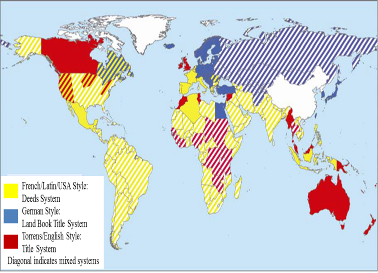 | Figure 1. World map of land registration systems (adapted from [7]) |
2.1. Land Management and Sustainability
- The concept of sustainable development has proper management of the environment as a key factor. According to [22], “Sustainable development is a notion, a movement and an approach which has developed into a global wave of concern, study, political mobilization and organization around the twin issues of Environmental protection and Economic development”. Land management involves distribution and management of a key asset (land) of any society. For western democracies, with their highly geared economies, land management is a key activity of both government and the private sector. Land management, and especially the central land administration component, aim to deliver efficient land markets and effective management of the use of the land in support of economic, social, and environmental sustainability [14]. The land management model as illustrated below (Figure 2) enhances the understanding of the role of land administration functions (land tenure, land value, land use, and land development) and how land administration institutions relate to the historical circumstances of a country and its policy decisions.
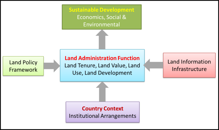 | Figure 2. Land management Model (After [8]) |
2.2. Integrated Land-Use Management
- Integrated land-use management is based on land policies laid down in the overall land laws, including the cadastral and land registration legislation as well as planning and building legislation. These laws identify the institutional principles and procedures for the areas of land and property registration, land-use planning, and land development [12]. More specific land policies are laid down in the sectorial land laws within areas such as agriculture, forestry, housing, natural resources, environmental protection, water supply, heritage etc. These laws identify the objectives within the various areas and the institutional arrangements to achieve these objectives through permit procedures, information policies, dispute handling, and so on [8]. The various areas produce sectorial programmes that include the collection of relevant information for decision making within each area. These programmes feed into the comprehensive spatial planning carried out at national, state/regional and local levels. Importantly, a mature system of comprehensive planning control needs to be based on appropriate and updated land use data systems, especially the cadastral register, the land book, the property valuation register, the building and dwelling register, etc. These registers need to be organized to form a network of integrated subsystems connected to the cadastral and topographic maps to form a national spatial data infrastructure for the natural and built environment. In the land-use management system (the planning control system) the various sectorial interests should be balanced against the overall development objectives for a given location and thereby form the basis for regulation of future land-use through planning permissions, building permits and sectorial land use permits according to the various land-use laws. These decisions are based on the relevant land use data and thereby reflect the spatial consequences for the land as well as society. In principle it can then be ensured that implementation will happen in support of sustainable development (see Figure 3).
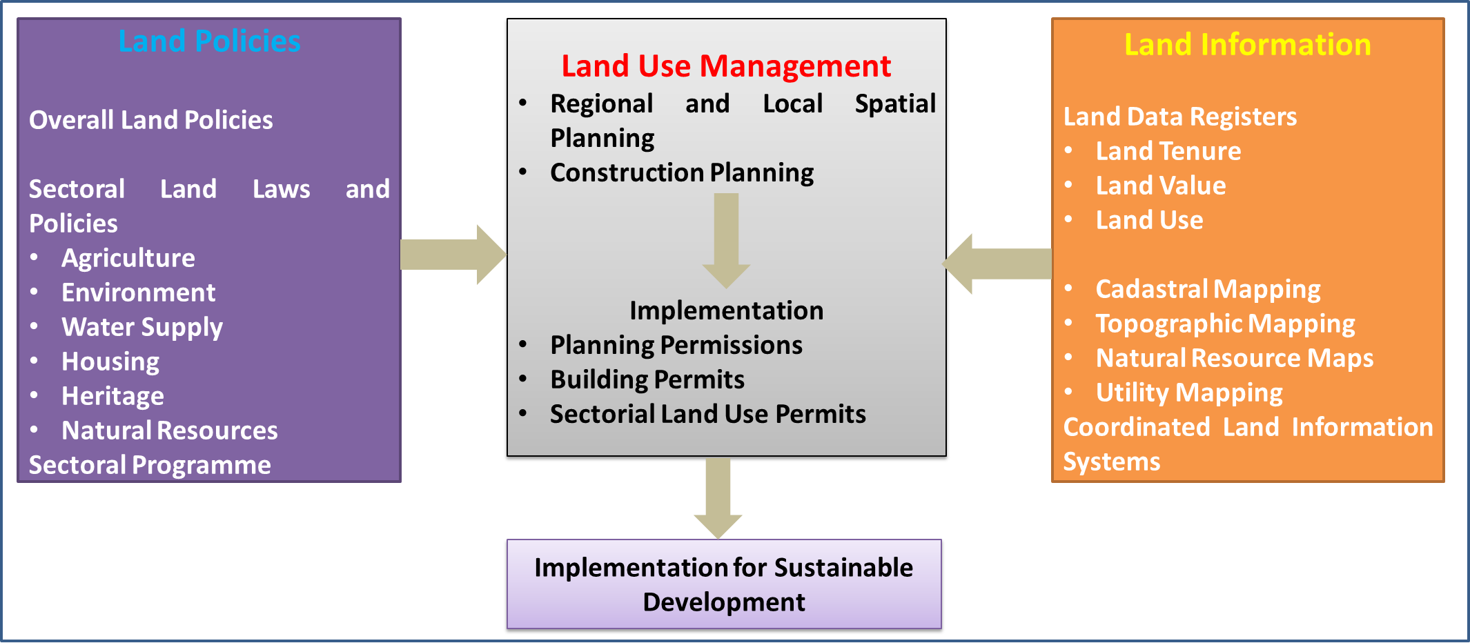 | Figure 3. Integrated land-use management for sustainable development (Source: [8]) |
2.3. The Nigerian Cadastral Systems
- In most countries, transfer of ownership of land is only possible upon registration of such land with relevant government authority. The property and the land registers are public and everyone is free to access them. In Nigeria, the Registry is organised [6] in three sections (Deeds, Titles and Plans). ● The Deeds Registry is responsible for receiving and storing all changes pertaining to interests in real property. ● The Title Registry provides a thorough check to .all relevant documents before registration is allowed. ● The Office of Surveyor-General (SG) is responsible for storing land records together with the plans showing legal boundaries of each land parcel. The Cadastre is considered as the official record of interest in land, which is the legally recognized registration of the quality, value and ownership of the land parcel [6]. According to the International Federation of Surveyors, “a Cadastre is normally a parcel based up-to-date land information system containing record of interests in land (e.g. rights, restrictions and responsibilities)”. Furthermore, a cadastre is a public land information system that supports the public administration of land [11].The failure of the Land Use Decree 1978 or Land Use Act 1980 has been detailed in [e.g. 2; 4, 16]. The causes of its failure include vesting the land in the government and that nobody must own more than half hectare land, whereas, essential maps covering a State indicating the ownership of each parcel of land are not available. Details that should be on such maps should include parcel boundary, parcel size, parcel ownership and sales history, parcel use and use history and land status (lease, rent or freehold) [4].The procedure for cadastre in Nigeria has always been by keeping data in files and cards. The files are stored in the land registry and subject to limited access [11]. They are traced serially. This method is popularly called “Conventional Paper File Record-Keeping”, that is analogue method. Its problems include susceptibility to mistakes, tracing a file can be difficult, accessing data in a file is tedious, it is ineffective as it encourages fraud, omissions, discrepancies and slowness. All these are eliminated with the GIS approach, [3]. Amidst numerous models of cadastre system that have existed in countries like Tanzania, Uganda, Britain, etc. Nigerian land registration system is a very faithful copy of Her majesty's Land Registry in London which had been in existence since 1862 [11]. Its function was to provide a safe, simple and economic system of land transfer in England and Wales. The Registry was not founded to create a general-purpose land information system for the public at large, rather a system whereby the interests of individual or corporate bodies owning land or legal interests of individual or corporate bodies owning land or legal interests in land are protected [3]. From the views of [1] and [10], the initial focus of land registration in Nigeria was the protection of land use rights and the establishment of security of tenure for users rather than taxation. Several Land Registration Acts had existed in Nigeria right from the pre-Independent era, these include; Act No.36 of 1924, Cap.56 of 1959 of the Laws of Western Nigeria, Land Instruments Registration Law Cap.72 of 1963 of the Laws of Eastern Nigeria [6]. The Acts prescribed that all instruments for registration must contain sufficient descriptions and plans of the affected land, and the plans must be countersigned by the Surveyor-General of the relevant State. The idea of land registration and adjudication of title had not been new to the country; but the problem had been that of decentralization and inefficiency, [3].
2.3.1. Defects of the Nigeria Cadastral System
- According to [19], the defects of the current practice are as follows:1. The same information is entered and stored repeatedly in different registers and documents thereby making the work strenuous and monotonous.2. The volumes of paper continue to grow, causing increase in storage space and management costs. 3. As paper records are transported from one location to another in response to demands from users, the rate of wear and tear is enormous, resulting in risks to the accuracy and availability of information.4. Access to records requires physical retrieval and reproduction, and land transactions can require weeks or months to complete.5. Linkage of data using common attribute data is not easily done and there is no room for flexibility because the data are in analogue (paper) format6. Human errors cannot be easily checked. The principal element of any modem cadastre is the digital cadastral map, for it's a large view of geographic area and it can be displayed and printed at different scales. Its major advantage is to display the spatial relationships between land objects. It is obviously organized into layers or themes giving information about properties, buildings, land use and population. On the other hand it must be a tool to describe the location, the shape and the contents of each object [11]. Other documents required in electronic land registration rely on encrypted digital signatures identifying the party submitting the document for registration. Documents are created and modified "on-line" on behalf of the vendor and purchaser with a property's legal description and ownership information retrieved from a centrally located land titles database automatically inserted.
3. A Model Land Information Systems
- In order to demonstrate the need for surveying and mapping in sustainable Land administration in Nigeria, a model Land Information System (LIS) was developed for Oduoye Estate in Minna Niger State.In doing this, the hard copy of the layout plan of the area was obtained from Niger State Ministry of Land and Housing. Spatial (location) data were also collected; this include the layout survey data showing the coordinate of the corners of all the lots in the layout obtained from survey Department of the Ministry, these data were acquired using a Promark3 single frequency Global Positioning System (GPS) receiver, while questionnaire was developed and administered in the area to obtain the attribute data.The layout map was scanned and georeferenced using the coordinate of some selected corners of the parcels as measured from the field using GPS (figure 4) also, using the coordinates, the bearings and distances of the sides of each lot were generated in AutoCAD 2010 software. The georeferenced map was later exported to Arc view GIS 3.2a software for vectorisation. The spatial and attribute (table 1) database was then created and the query builder tool in Arc view GIS was used to build the query based on different scenario as needs demand (figures 5 and 6 respectively).
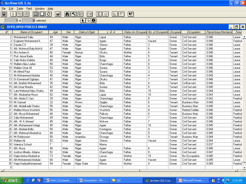 | Table 1. Parcel Database |
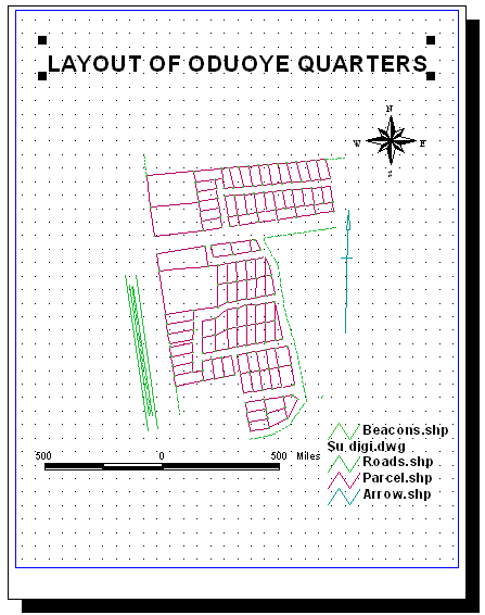 | Figure 4. Base map of the study area |
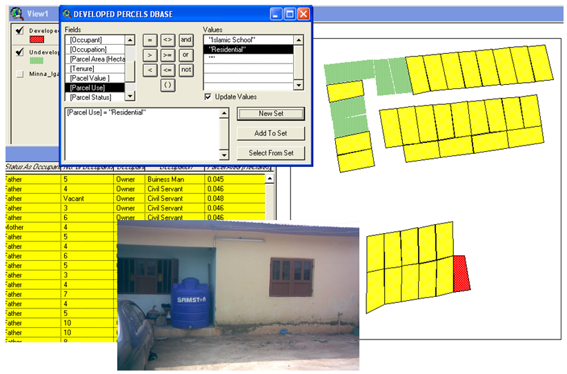 | Figure 5. Query showing Parcels used for Residential purpose |
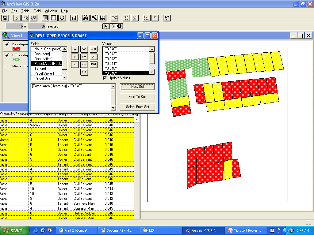 | Figure 6. Query showing Parcels whose plot sizes are equal to 0.046 hectares |
4. Applications of Surveying in Socioeconomic Development
- The application of surveying in socio-economic development of Nigeria cannot be over emphasized. This stems from the fact that survey data or geoinformation forms about 80% of the required information for development or improvement of any physical infrastructure (be it road, dam, bridge, rail line, port, or even housing development). Also, the realization of the dreams of National Space Research and Development Agency (NASRDA) will be farfetched if the survey contents of the Centre for Remote Sensing and the Centre for Geodesy and Geodynamics (CGG) are not well articulated and properly implemented. These are aids to the development and improvement of critical infrastructure as indicated in the transformation agenda of the Federal Republic of Nigeria.Furthermore, the need for map and map related data for farm planning and the use of GIS for Agricultural land classification and selection speaks volumes on the relevance of surveyors in the realization of national food security. Detail applications of surveying and mapping according to [20] are given in table 2 below.
5. Conclusions
- Land administration systems, in principle, reflect the social relationship between people and land recognized by any particular jurisdiction or state. Such a system is not just a GIS. On the other hand, land Administration Systems is not an end in itself but facilitate the implementation of the land policies within the context of a wider national land management framework. Land administration activities are, not just about technical or administrative processes; the activities are basically political and reflect the accepted social concepts concerning people, rights, and land objects with regard to land tenure, land markets, land taxation, land-use control, land development, and environmental management, land administration systems therefore need high-level political support and recognition. Thus, in this paper, the concept of land administration systems has been discussed, while various applications of surveying and mapping in solving both human and socio-economic problems were presented; the roles of Surveyors in the successful implementation of the transformation agenda of the Federal Government of Nigeria were thus examined, also a prototype land information system was developed and it was observed that the need for surveying and mapping is indispensable in sustainable land administration/management. This is because they provide the basic information required to create the GIS for land management. Hence, it suffices to state that no nation can build land management institutions without thinking about integration of activities, policies, and approaches. Technology opportunities provide additional motivation. Careful management of land related activities on the ground are crucial for delivery of sustainability. Therefore, there is the need to accord surveying and mapping its rightful place and priority in the national development programme.
References
| [1] | Adedunrin, I.O., (2000): Potential of Digital Cadastral Map for Revenue Generation. National Concord, Thursday January 20, 2000. |
| [2] | Adalemo, I.A. (1982): “Cartography, Maps and National Development”, in Ayeni, O. O. (ed.), Mapping for National Development in Nigeria, Special Publication NCAP-1 of the Nigerian Cartographic Association, pp 3-12. |
| [3] | Adesina, J. G. (2005): Application of Cadastral GIs in Township Map Revision for Successful Implementation of Land Registration. A Paper Presented at the 40th Annual General Meeting (AGM) and Conference with the theme: Up-to-date maps: A Tool for Land Registration and Sustainable Economic Development, held in Kano 3rd - 6th may. |
| [4] | Balogun, O. Y (2003): Enter The World Of Maps: You Can Never Miss Your Way, An Inagural Lecture delivered at the University of Lagos on Wednesday 16th July, 2003, 57pp. |
| [5] | Bo Lauri (2007): Spatial Information, an Important Part of the Infrastructure in Sweden Strategic Integration of Surveying Services. FIG Working Week 2007, Hong Kong SAR, China 13-17 May. |
| [6] | Dashe, J.D.J. (1987): Cadastral Surveying Practice in Nigeria. Department of Printing Technology, Kaduna Polytechnic, Kaduna. |
| [7] | Enemark, S. (2004): Building Land Information Policies. Proceedings of Special Forum on Building Land Information Policies in the Americas. Aguascalientes, Mexico, 26-27 October.http://www.fig.net/pub/mexico/papers_eng/ts2_enemark_eng.pdf. |
| [8] | Enemark, S. (2008): Environment and Land Administration - Focus on Rights, Restrictions and Responsibilities. FIG Commission 7 International Symposiums, Verona, Italy, 14 September.http://www.fig.net/pub/mexico/papers_eng/ts2_enemark_eng.pdf. |
| [9] | Enemark, S. and McLaren, R. (2008): Preventing Informal Development – through Means of Sustainable Land Use Control. Proceedings of FIG Working Week, Stockholm, 14-19 June .http://www.fig.net/pub/fig2008/papers/ts08a/ts08a_01_enemark_mclaren_2734.pdf. |
| [10] | Fabiyi, Y. L., (1990): Land Policy for Nigeria: Issues and Perspectives. Inaugural Lecture Series No. 99 delivered at Obafemi Awolowo University, Ile-lfe on June 12, 1990. P.16. |
| [11] | Fadahunsi, J. T. and Oluwadare, C. O (2005): Automated Land Registration In Nigeria. A Paper Presented at the 40th Annual General Meeting (AGM) and Conference with the theme: Up-to-date maps: A Tool for Land Registration and Sustainable Economic Development, held in Kano 3rd - 6th may. |
| [12] | FAO (2007): Good Governance and Land Tenure and Administration, FAO Land Tenure Series no 9. Rome. ftp://ftp.fao.org/docrep/fao/010/a1179e/a1179e00.pdf. |
| [13] | FIG, (1998): Cadastre 2014: A Vision for a Future Cadastral System. FIG Commission 7. |
| [14] | Jacobs, H.M. (2007): Social Conflict Over Property Rights, Land Lines, Lincoln Institute of Land Policy, April, pp.14-19. https://www.lincolninst.edu/pubs/dl/1222_LLA070404SocialConflictOverPropertyRights.pdf. |
| [15] | Kufonniyi, O. (1998): Database design creation on principles and application of GIS. Panel press Pp 46-47. |
| [16] | Mabogunje, A. L. (1982): “Order on the Land”, in Ayeni, O. O. (ed.) Mapping for National Development in Nigeria, Special Publication NCA-1 of the Nigerian Carto. Asso., pp13-22. |
| [17] | Musa, A (2003): The Role of Geoid In Geospatial Information Systems. Paper Presented at the Annual Seminar Series in Military Geography, Department of Geography, The Nigerian Defense Academy, Kaduna, Nigeria, 11th September. |
| [18] | Nwilo, P. C. (2003): The Role of Spatial Reference System Framework and Fundamental Data Sets in National Geospatial Data Infrastructure (NGDI). In Proceedings of the National Geospatial Data Infrastructure (NGDI), Stake Holders Workshop; Abuja, Nigeria, pp25-31. |
| [19] | Ogundele, R. A. (2005): A Well Structured and Updated Multipurpose Cadastral As A Panacea for Map Revision. A Paper Presented at the 40th Annual General Meeting (AGM) and Conference with the theme: Up-to-date maps: A Tool for Land Registration and Sustainable Economic Development, held in Kano 3rd - 6th may. |
| [20] | Oluwamotemi, K (2005): National Mapping Agency: A Necessity for the Development and Management of Geo - information for Rapid Development and Sustainable Physical and Economic Growth. A Paper Presented at the 40th Annual General Meeting (AGM) and Conference with the theme: Up-to-date maps: A Tool for Land Registration and Sustainable Economic Development, held in Kano 3rd - 6th may. |
| [21] | Opaluwa, Y. D. (2008): Determination of Optimum Geometrical Interpolation Technique for Modelling Local Geoid and Evaluation of GPS Derived Orthometric Heights. An M. Sc. Dissertation, University of Lagos, Nigeria. |
| [22] | UN (2000): United Nations Millennium Declaration. Millennium Summit, New York, 6-8 September 2000. UN, New York.http://www.un.org/millennium/declaration/ares552e.pdf. |
| [23] | UN-Habitat (2003): Handbook on Best practices, Security of Tenure and Access to Land. ISBN: 92-1-131446-1. UN-Habitat, Nairobihttp://www.unhabitat.org/pmss/getPage.asp |
| [24] | UN- Habitat (2008): Secure Land Rights for all. UN Habitat, Global Land Tools Network.http://www.gltn.net/en/e-library/land-rights-and-records/. |
| [25] | Williamson, I.P. and Wallace, J. (2007): New Roles of Land Administration Systems. Paper presented at the International Workshop on Good Land Administration - Its Role in Economic Development, Ulaanbaatar, Mongolia, 27-29 June. |