-
Paper Information
- Next Paper
- Previous Paper
- Paper Submission
-
Journal Information
- About This Journal
- Editorial Board
- Current Issue
- Archive
- Author Guidelines
- Contact Us
American Journal of Geographic Information System
p-ISSN: 2163-1131 e-ISSN: 2163-114X
2014; 3(1): 38-44
doi:10.5923/j.ajgis.20140301.04
The Evolution of GIS as a Land Use Planning Conflict Resolution Tool: A Chronological Approach
 Abstract
 Reference
 Full-Text PDF
 Full-text HTML
Emad Dawwas
Urban Planning Department, An-Najah National University, Nablus, P.O. Box: 7, Palestine
Correspondence to: Emad Dawwas, Urban Planning Department, An-Najah National University, Nablus, P.O. Box: 7, Palestine.
| Email: |  |
Copyright © 2012 Scientific & Academic Publishing. All Rights Reserved.
This paper argues that there is a reciprocal relationship between the emerging planning approaches and the GIS techniques adopted in the land use planning process. Such relationship is explained by providing an extensive literature review on the evolution of the GIS and the history of planning theories including the rational, advocacy, communicative, and multiculturalism approaches. The paper gives special emphasis to the types of conflict involved in the various planning perspectives. The conceptual scheme reflects the chronological developments in GIS technologies and techniques used in the land conflict resolution as related to the shifts in the planning theories from 1960s onward. The proposed framework is focused on two main guiding principles: 1) the conflict in the land use planning process and 2) the GIS techniques used to handle such conflict. The first principle, which emphasizes the land use planning as a multi-actor process, often triggers interest driven and cognitive types of conflict. The second principle predominantly views the role of GIS as a conflict resolution tool ever since it was invented in the early 1960s. The paper concludes that as the planning process moved from technical orientation to the highly participatory approach, the level of conflict dramatically increased as a result of involving more stakeholders whose values and desired outcomes had to be reflected in the plan making process. Such shifts in planning perspectives significantly influenced the developments in the adopted GIS techniques overtime. These techniques became more advanced and sophisticated in response to the rising levels of conflict in the planning process.
Keywords: GIS modeling, Planning process, Land use conflict, Conflict resolution
Cite this paper: Emad Dawwas, The Evolution of GIS as a Land Use Planning Conflict Resolution Tool: A Chronological Approach, American Journal of Geographic Information System, Vol. 3 No. 1, 2014, pp. 38-44. doi: 10.5923/j.ajgis.20140301.04.
Article Outline
1. Introduction
- The land use planning is a multi-stake process in which different stakeholders attempt to maximize their own benefits and satisfy their personal interests. In addition to its being a means to organize the future land uses and to solve the resulting conflict, the planning process, is a source of conflict as a multi-actor process. The term conflict in the planning jargon is associated with a wide spectrum of situations and does not have a universal definition. Conflict in the planning process might be any type of disagreement among a number of parties or stakeholders about who has the right to make the decision and within what spatial and temporal scale, and/or about the most appropriate mechanisms of making the decision, and/or about how the outcomes of the planning process will be implemented. This paper will focus on the conflict that is related to the mechanisms of making decisions within the planning process as well as the conflicts resulting from the disagreement on the planning values which underlie the planning policies and their future implications. The multi-stake character of the planning process and the ensuing conflict make the planners function within a complex and turbulent environment, and focus their effort more on mediating the conflict among different actors. Consequently, planners have employed a wide range of technologies and techniques in order to make good plans and successfully implement them. One of the most important among these technologies is the geographic information systems (GIS). GIS has been extensively used in the planning process since its invention and introduction to the planning process in the early 1960s. This paper will mainly focus on the interaction between the conflictual planning approaches and the evolution of the GIS techniques which have been employed to deal with the emerging conflicts. This will be achieved by investigating the relationship between different types of planning conflict and the GIS techniques used to ameliorate them. The paper provides a conceptual framework to illustrate the chronological developments in GIS technologies and techniques, and to link those to the dominant planning approaches and their conflict points.
2. Conceptual Framework
- Using a multi-actor context as the context of the land use planning process, conflict can be attributed to two main sources: disagreement on facts referred to as “cognitive conflict” and disagreement regarding values referred to as “interest conflict”[1]. Cognitive conflict exists when different parties base their decisions on different facts or on the same facts that are construed differently. Interest conflict occurs when individuals have different values or desire different outcomes. Centered on these definitions, the evolution of the GIS as a tool to handle the land conflict have been a function of the development of technology, and a function of the evolving perspectives of planning that represent the atmosphere in which the conflict is being handled. As shown in Figure (1), GIS has passed through four main stages since its advent in the early 1960s. These shifts in GIS and related technologies, and shifts in the planning perspectives have affected the way the two main components of the conflict (the cognitive conflict and interest conflict) have been treated as well as the techniques used in the resolution process. As the planning process became more democratized and involved more participants, the interest component of the conflict was given more importance. This made the technology and the techniques needed to handle the conflict more capable of handling values and subjective issues and combining them with facts and objective issues. This notion will be deliberately discussed through a chronological examination of the developments in GIS technologies and techniques used in the land use conflict resolution, taking into account shifts in the planning theories during each decade from 1960 onward.
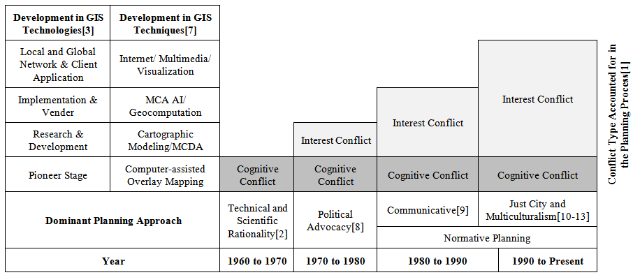 | Figure 1. GIS technologies and techniques evolution and the conflict components encountered in the evolving planning approaches |
2.1. First Stage: 1960s to 1970s
- Before the middle of the 20th century, urban planners were primarily concerned with abstract values of good form and spatial arrangement. Planning was perceived as large-scale architecture, and therefore the cities were viewed as large-scale architectural objects[2]. During this period, landscape architects and planners influenced the technology used in the planning process[3]. Although GIS had not been invented at this point of time, the road had been paved for this technology to evolve through advancements in the scientific field represented by the emergence of new quantitative theories and through technological developments—namely the emergence of the computer[4]. From the mid-1950s up to the late 1960s, the planning process went through a dramatic transition from the engineering approach which was concerned with the design of the physical elements of the city to a technical and scientific rational approach focusing on the quantitative techniques and theories of the social sciences[2]. The dominant image of planning was portrayed as a rational process that applied scientific knowledge and techniques to the management of public affairs[5]. Within this context of planning, the GIS was in its pioneer stage and the inevitable question was posed: what role can GIS play in land use planning? At that time, the primary goal of using GIS was to take raw data and transform them into new information which could support the decision-making process[4]. This created the belief that GIS would significantly help minimize conflict regarding land use, because the central issue was the amount of information available for the planners[6]. The belief began with the premise that GIS makes greater quantities of data and information within the framework of a computerized package more readily available and accessible.The perceived GIS role in land use conflict during this period was based on three main assumptions about the information[6]: (1) information is a "value-" and "politically neutral" resource; (2) a clear distinction between the "objective" facts stored in a computer and the "subjective" opinions and values of individuals and groups could be made; and (3) the more information planners have the better results they obtain and a higher quality of planning can be maintained. Therefore, the most important role of planners in this period was to provide more information of higher quality that could inform and improve the policy-making process. Based on this last assumption, GIS in its pioneer stage was perceived as a data-centered information technology that provided tools for deriving information from databases to be used in the rational planning process[7].The common definition and the perception of planning as a technical issue made the planners treat the land use conflict as a cognitive conflict that could be solved by generating more facts. Within this definition of conflict, GIS was a powerful tool as it succeeded to overcome the limitations of manual methods of combining high numbers of facts about the conflict by introducing the computer-assisted overlay techniques that could deal with large datasets[7]. The role of GIS technologies in land use conflict management was severely criticized, mainly because it was based on inaccurate assumptions (the aforementioned three assumptions)[1]. These criticisms were part of a larger complaint against the dominant planning approach as a whole that assumed the existence of an objective reality in which all parties could agree. In the mid-1960s, Paul Davidoff[8] criticized this approach because it excluded the public from participating in the process of rational planning or what he called the “unitary plan”, and so he introduced advocacy planning as an alternative to technical and scientific rational planning.
2.2. Second Stage: 1970s to 1980s
- Advocacy planning was the first step in departing from the rational scientific approach in planning towards the democratic participatory approach[14]. As advocacy planning emerged, planners had a professional commitment to actively advocate on behalf of the powerless members of society. They were obliged to do more than the job of explicating values underlying their courses of action, but needed to verify them and then be advocates for what they thought was proper[8]. By considering the interests of the general public (through their advocacy), the value component of the conflict was considered in the conflict resolution process. Accordingly, the role of GIS was expanded from dealing with only facts (quantities) towards dealing with values (interests) in addition, which reflected on the techniques used in solving land use conflicts. Boolean operations and weighed linear combinations (WLC) advanced by introduction of cartographic modelling and map algebra techniques into computer-assisted mapping were used to handle land use conflicts[7].In spite of the clear successes with advocacy planning, it was criticized for its potential to continue the previous dilemmas of rational planning, as mentioned by Krumhulz [14]. Such dilemmas included: disappointed expectations from planners towards the group(s) of interest; the lack of power to solve other huge or larger problems; and the difficulty of representing the many different interests within a given group. All of these critiques paved the road to the emergence of a new planning perspective known as the communicative perspective that was associated with dramatic changes in the GIS technologies and techniques.
2.3. Third Stage: 1980s to 1990s
- Communicative planning evolved as an alternative to advocacy planning in order to assure the reformative goals of planning[15]. Communicative planning theorists were based on Habermas’s communicative rationality. The idea of Habermas was that consensus and coordinate actions were possible within the life-world by rational and inherently democratic human beings through the process of communication[16]. As part of this new shift in the planning paradigm, planners realized that besides the typical functions of map preparation and analyses, planners needed to negotiate, bargain, explain, and administer (and debate) planning rules and regulations[7]. As these activities added the social component to the conflict resolution process, the rationality of planning, therefore, went beyond being based on pure logic and the abstract evaluation of evidence but rather on an informed consensus formed by a community of individuals in a particular place and time[17].In terms of the cognitive and interest conflicts, the involvement of the general public and other groups allowed for their diverse interests to be directly present in the conflict resolution process rather than channeling them through the advocacy planners. This, in turn, increased the importance given to the interest conflict component and affected the GIS techniques used. Technically, Boolean operations and WLC methods were not sufficient within this context as they oversimplified the complexity of the process underlying conflict problems by focusing on the facts rather than focusing on an appropriate combination of facts and values[7]. This limitation was a major incentive to adopt multicriteria decision making methods (MCDM) and integrating them with GIS (GIS-MCDM systems). These systems proved to have high capabilities in resolving the land use conflicts such that GIS provided a tool for handling the disagreements over facts (the cognitive component of the conflict) by providing more information of higher quality, while the MCDM techniques helped in diminishing the disagreements over values among the conflicting interest parties[18]. Despite its wide range of advantages and the dramatic changes made to planning theory and practice, and despite the successful employment of GIS technology, the communicative planning perspective was targeted by a strong wave of critics. The most important criticism was that consensus building does not take power into account and that powerful players will co-opt the other players, control outcomes, and dominate the process[19]. The power imbalance also threatened the role of GIS as a neutral tool being used in the conflict resolution process. As a result, consensus-building resulted in nothing more than compromise and the lowest common solutions, often reached through the pressure of peers. Consensus building was ultimately considered to be a waste of time because players could opt out of agreements at any time, and therefore communicative planning lost favor[19].
2.4. Fourth Stage: 1990s to Present
- Since the 1990s, GIS applications in land use conflict resolution have witnessed two dramatic changes due to the emerging planning theories and new environmental acts. These changes cannot be separated or ordered chronologically as the ones before, so they will be discussed under the same time period in the following two sub-sections.
2.4.1. The Emerging Planning Theories
- After 1990, different theories in the urban planning field emerged such as the just city theory[10, 11] and the planning in multicultural and fragmented societies[12, 13]. According to these theories, the demands of different stakeholders are determined not only by their socioeconomic characteristics but also by their cultural and ethnic backgrounds. The involvement of ethnocultural issues in the planning process added another dimension to the conflict by addressing ethnic and racial considerations. This conflict dimension is, in the first place, a type of interest conflict rather than cognitive conflict. However, the cognitive part of the conflict was not completely altered, but it existed without experiencing substantial changes. Consequently, the GIS techniques and technologies responded to this shift in the planning theories by increasing capabilities in handling values (represented in interest component) and combining them with facts (represented in the cognitive component) to allow more people to be involved and more perspectives to be accounted for in the conflict resolution process. As to the changes in GIS capabilities to deal with the interest component, the techniques (GIS-MCDM) that had been used were criticized for not being able to deal with conflict in its new shape in which the interest component had dramatically elevated. According to Jiang and Eastman[20], several studies demonstrated that considerably different results are usually generated when different traditional multicriteria evaluation techniques—used in the previous era—are applied to the same case. In order to overcome this limitation, the solution adopted was to integrate MCDA and Artificial Intelligence (AI) techniques with GIS to develop the knowledge-based or ‘intelligent’ multicriteria decision support. Accordingly, many advanced models integrating individual components of AI and GIS have emerged. Some of the attempts to develop mix systems including the integration of GIS and AI methods such as fuzzy logic techniques[21-23], Cellular Automata[24-26], genetic or evolutionary algorithms[27, 28] and artificial neural networks artificial neural networks[29-31]. Regarding the cognitive part of the conflict, GIS software can apply remote sensing imagery, terrain elevation models, and other digital data layers to visualize the extent of the area in dispute, the types of resources at risk, populations who might be affected, and other considerations. Due to the instability in these areas, GIS is also a proven means for exploring ‘what if’ scenarios for proposed territorial changes. The parties can view each territorial change proposal in light of how it might affect their strategic and national goals. GIS can also help clarify the spatial elements of a territorial dispute and its socio-economic and military implications. Due to these powerful capabilities, GIS can play a key role in solving territorial conflict when there is technology and data available and accessible to all disputing parties. Otherwise, it might play an opposite role when it and the related data and technologies are controlled by one party. Effective GIS use therefore requires all parties to commit to the transparent development of data bases relevant to the dispute. A suggested approach to achieve preliminary confidence building measures is to include joint training in use of GIS tools and data base management, as well as a sustained collaborative effort to construct accessible and reliable data layers for the disputed area. Such steps would establish a knowledge base that would enable future discussions of possible territorial options.
2.4.2. Environmental Regulatory Changes
- Regarding the second change referred to above (i.e. new environmental acts), the 1990s witnessed environmental regulatory changes represented in the passage of the Clean Air Act Amendments (CAAA) in 1990 and the Intermodal Surface Transportation Efficiency Act (ISTEA) in 1991in the United States[32], and, one decade later, the Clean Air for Europe (CAFE) Program[33]. According to these acts, metropolitan organizations (MPOs) became more responsible for reducing air pollution which required them to define a comprehensive regional vision[34]. The emergence of the environmental acts resulted in increasing the interest and the cognitive conflicts. It increased the interest component by giving high importance to the environmental values which resulted in increasing the conflict between these values and other land use planning values including economic, social, and liveability values, and it magnified the conflict among adjacent MPOs. On the other hand, it increased the cognitive conflict by requiring each MPO and other administrative units to present a high number of facts on their emission levels and the expected environmental impacts of their proposed plans before they are officially approved. This had put extra burden on the planners’ shoulders as they were required to ameliorate this conflict and to design land uses that are in compliance with the new environmental regulations. This, in turn, required conducting advanced technical analysis and using huge data sets in order to build a number of scenarios representing the likely future and its environmental consequences. As accomplishing such sophisticated endeavour required advanced computational capabilities that go beyond GIS capabilities, a general consensus emerged among urban planners to integrate the urban analytical models that are powerful analytical and computational tools with GIS as a visualization and data manipulation tool[34].Urban modelling systems including GIS capabilities were recommended by the US Department of Transportation’s Travel Model Improvement Program and Land Use Modelling Conference as tools to be employed, in addition to other purposes, in solving the conflict among different actors of the development process[35]. Some urban analytical models have been completely integrated with GIS to take advantage of GIS capabilities in manipulating data and visualizing results such as in the California Urban Futures Model (CUF)[36] as well as in METROPILUS which is housed within a GIS environment to improve visualization of output[17]. Activity-based forecasting models incorporating GIS applications have also been developed by McNally[37], and Cellular Automata (CA) models have also been integrated with GIS in several studies like Batty and Xie[38]. ILUMASS has GIS components combining raster and vector-based representations to allow for the advantages of spatial disaggregation in land use representation and efficient network algorithms for transportation network modelling [39].Regarding the most recent GIS technological developments—it became feasible for a wider range and higher number of stakeholders and individuals to be involved via Internet-GIS and Web-GIS[40-42]. These technological developments are considered to be the most significant trends in GIS technology of this period[7]. Accordingly, GIS has become generally more accessible and groups that have had a stake in the outcomes of decisions made by public officials are able to present their own scenarios and analyses. GIS has also become a tool of planning that is employed by community groups and non-governmental organizations as part of their planning efforts, and it is no longer a tool used exclusively by professional planners and consultants.
3. Limitations of Applicability
- The applicability of the proposed conceptual framework is limited by the fact that GIS tools are neutral ones and cannot be successfully employed unless the confronting parties have the will to resolve the conflict and are prepared to exchange ideas rationally. Rationality here means minimizing the tension, mistrust, poor communication conditions, intense emotions, ambiguity of goals, and confusion over roles.Within the same context, the information used in the planning process is usually controlled by different levels of political power. This makes the role of such information extremely essential and sensitive due to its effect on the interest and on the cognitive conflict. Liberal democratic and united societies typically have higher levels of data availability which are more readily accessible compared to non-democratic and divided societies. In the latter case, information can be used by the central government to misguide the public—especially the minority fraction of the public. Regardless of the advancement of the tools that are used to prepare land use plans, these limitations prevent planners from effectively acting as mediators to resolve conflicts and advocates to advance the interests of underrepresented groups.
4. Conclusions
- The suggested framework has shown that the developments in the GIS techniques have occurred in parallel with the evolving planning approaches. There is a reciprocal relation between the GIS techniques and the level and type of conflict in the planning process. From one side, the planning process has become more complex and turbulent as it moved from the more technical processes to more participatory and democratized ones, and as the levels of conflict (especially the interest component) increase. From another side, the need for advanced GIS increases as the planning process becomes more sophisticated, a thing which reflects on the complexity and advancement of GIS techniques employed in the planning process. As the multiculturalism theories emerged and GIS became a more available and accessible tool, planners and politicians in areas of ethnocultural conflicts were motivated to employ GIS in resolving land conflict. Finally, all these conclusions about the proposed conceptual framework are conditioned by the political context and the data availability and accessibility in a particular area. It is important that future research address the relevance of applying GIS techniques in highly divided societies where space utilization is more ideologically driven. In such societies, the planning context may require a wholly different set of GIS applications.
ACKNOWLEDGEMENTS
- The author would like to thank Prof. Donald Miller and Prof. Timothy Nyerges from the University of Washington, who kindly read and reviewed an earlier draft of this paper for their valuable suggestions.
References
| [1] | Obmeyer N., 1994, Spatial Conflict in the Information Age, URISA Proceedings, pp. 269-282.[Online]. Available: http://libraries.maine.edu/Spatial/gisweb/spatdb/urisa/ur94024.html |
| [2] | Couclelis, H., 1991, Requirements for planning-relevant GIS: A spatial perspective, Papers in Regional Science, Vol. 70 (1), pp. 9-19. |
| [3] | Foresman, T., 1998, The history of geographic information systems: perspectives from the pioneers, Upper Saddle River NJ: Prentice Hall PTR. |
| [4] | Al-Naqi A., GIS in municipal, public and private agencies, PhD. Dissertation, UNIVERSITY OF MIAMI Coral Gables, Florida, 1988. |
| [5] | Worrall, L., 1990, Geographic information systems: developments and applications, London, New York: Belhaven Press. |
| [6] | Forester, J., 1989, Planning in the Face of Power, University of California Press. |
| [7] | Malczewski, J., 2004, GIS-based land-use suitability analysis: a critical overview, Progress in planning, Vol. 62 (1), pp. 3-65. |
| [8] | Davidoff, P., 1965, Advocacy and Pluralism in Planning, Journal of the American Institute of Planners, Vo. 31(4), pp. 544-555. |
| [9] | Watson, V., 2002, The usefulness of normative planning theories in the context of Sub-Saharan Africa, Planning Theory, Vol. 1(1), pp. 27–52. |
| [10] | Fainstein, S., 2005, Planning Theory and the City. Journal of Planning Education and Research, Vol. 25, pp. 121-130. |
| [11] | Mitchell, Don., 2003, The Right to the City: Social Justice and the Fight for Public Space, New York: Guilford Press. |
| [12] | Bollens, S., 1998, Urban Planning Amidst ethnic Conflict: Jerusalem and Johannesburg, Urban Studies, Vol. 35 (4), pp. 729-50. |
| [13] | Healey, P., 1997, Collaborative Planning: Shaping Places in Fragmented Societies, New York: Palgrave Macmillan. (check this ref.) |
| [14] | Krumholz, N., 1994, Dilemmas of equity Planning: A Personal Memoir, Planning Theory (Franco Angeli Series) No. 10-11, pp. 45-56. |
| [15] | Watson, V., 2006, Deep Difference: Diversity, Planning and Ethics, Planning Theory, Vol. 5(1), pp. 31-50. |
| [16] | Habermas, J., 1984, The theory of communicative action. Boston: Beacon Press. |
| [17] | Brail, R., 2001, Planning support systems: integrating geographic information systems, models, and visualization tools. Redlands Calif.: ESRI Press. |
| [18] | Feick, R.D., Hall, G.B., 1999, Consensus-building in a multi-participant spatial decision support system, URISA Journal, Vol. 11 (2), pp. 17–23. |
| [19] | Innes, J. E., 2004, Consensus Building: Clarification for the Critics, Planning theory, Vol. 3 (1), pp. 5-20. |
| [20] | Jiang, H., Eastman, J.R., 2000, Application of fuzzy measures in multi-criteria evaluation in GIS, International Journal of Geographical Information Systems Vol. 14, pp. 173–184. |
| [21] | Burrough, P. A., MacMillan, R. A. and van Deursen, W., 1992, Fuzzy classification methods for determining land suitability from soil profile observations and topography. Journal of Soil Science Vol. 43, pp. 193–210. |
| [22] | Hall, G. B., Wang, F., and Subaryono, 1992, Comparison of Boolean and fuzzy classification methods in land suitability analysis by using geographical information systems. Environment and Planning A, Vol. 24, pp. 497-516. |
| [23] | Wanek D., 2003, Fuzzy Spatial Analysis Techniques in a Business GIS Environment. European Regional Science Association-ERSA conference papers ersa03p177. |
| [24] | Keith C. and Leonard J., 1998, Loose-coupling a cellular automaton model and GIS: long-term urban growth prediction for San Francisco and Washington/Baltimore, International Journal of Geographical Information Science, Vol. 12, Issue 7, pp. 699-714. |
| [25] | Xia L. and Anthony G., 2000, Modelling sustainable urban development by the integration of constrained cellular automata and GIS, International Journal of Geographical Information Science, Vol.14 (2), pp. 131-152. |
| [26] | Batty, M., & Xie, Y., 1994, Urban analysis in a GIS environment: population density modeling using ARC/INFO, In A. S. Fotheringham, and P. A. Rogerson, Spatial analysis and GIS, London: Taylor and Francis, pp. 189-219. |
| [27] | Theodor S., Janssenb R., van Herwijnenb M., 2004, A genetic algorithm approach to multiobjective land use planning, Computers & Operations Research, Vol. 31 (14), pp. 2293–2313. |
| [28] | Xia L. and Anthony G., 2005, Integration of genetic algorithms and GIS for optimal location search, International Journal of Geographical Information Science, Vol. 19 (5), pp. 581-601. |
| [29] | Wang, F., 1994, The use of artificial neural networks in a geographical information system for agricultural land- suitability assessment, Environment and Planning A Vol. 26, pp. 265-284. |
| [30] | Bryan C., Daniel B., A. and Gaurav M. 2002, Using neural networks and GIS to forecast land use changes: a Land Transformation Model, Computers, Environment and Urban Systems, Vol. 26 (6), pp. 553–575. |
| [31] | Pijanowski, B., Brown, D., Shellito, B. and Manik, A., 2002, Using neural networks and GIS to forecast land use changes: A Land Transformation Model. Computers, Environment and Urban Systems Vol. 26, pp. 553-575. |
| [32] | Bullard, R., 1997, Just transportation : dismantling race and class barriers to mobility. Gabriola Island BC, Stony Creek, CT: New Society Publishers. |
| [33] | Wagner, F., Schopp, W. and Heyes, C., 2006, The RAINS optimization module for the Clean Air For Europe (CAFÉ) Program.[Online]: Available:IR-06-029.pdf |
| [34] | Hanley, J. and Marshall N., 1997, An Integrated Computer Modeling Environment for Regional Land Use, air Quality, and Transportation Planning, SANDIA REPORT.[Online]. Available: http://citeseer.ist.psu.edu/368824.html. Accessed on 04/13/2008. |
| [35] | Bartholomew K., 2005, Integrating Land Use Issues into Transportation Planning: Scenario Planning.[Online]. Available: www.arch.utah.edu/SP_SummaryRpt_Web.pdf |
| [36] | Landis, J. and Zhang M., 1998, The second generation of the California urban futures model, Part 1: Model logic and theory, Environment and Planning B: Planning and Design, Vol. 25 (5), pp. 657 – 666. |
| [37] | McNally, G., 1996, The Potential for Integrating GIS in Activity-Based Forecasting Models.[Online]. Available: http://escholarship.org/uc/item/2js9554x. |
| [38] | Batty, M. and Xie Y., Sun Z., 1999, Modeling urban dynamics through GIS-based cellular automata. Computers, Environment and Urban Systems, Vol. 23, pp. 205-233. [Online]._Available:http://www.bartlett.ucl.ac.uk/casa/latest/software/files-for-download/ceus-paper.pdf. |
| [39] | Strauch, D., Grafe, J., Moeckel, R., Wegener, M., Muhlhans, H., Rindsfuser, G. and Beckmann K., 2003, Linking Transport And Land Use Planning: The Microscopic Dynamic Simulation Model Ilumass.[Online]. Available: http://www.geocomputation.org/2003/Strauch_Abs.pdf. Accessed on 05/28/2008. |
| [40] | Chaowei Y., David W., Ruixin Y., Menas K. and Qi L., 2005, Performance-improving techniques in web-based GIS, International Journal of Geographical Information Science, Vol. 19 (3), pp. 319-342. |
| [41] | Dragicevic, S., 2004, The potential of Web-based GIS, Journal of Geographic Systems, Vol. 6, pp. 79-81. |
| [42] | Yoon, C. and Hyeong, P., 2006, XML Web Service-based development model for Internet GIS applications, International Journal of Geographical Information Science, Vol 20 (4), pp. 371-399. |