-
Paper Information
- Previous Paper
- Paper Submission
-
Journal Information
- About This Journal
- Editorial Board
- Current Issue
- Archive
- Author Guidelines
- Contact Us
American Journal of Geographic Information System
p-ISSN: 2163-1131 e-ISSN: 2163-114X
2014; 3(1): 10-22
doi:10.5923/j.ajgis.20140301.02
A GIS Based Decision Support System for Identification of Suitable Sewerage Pond Sites in Tanzania
 Abstract
 Reference
 Full-Text PDF
 Full-text HTML
Yahaya Msangi1, Evaristo Liwa2
1Shinyanga Municipal Council, Tanzania
2School of Geospatial Sciences and Technology, Ardhi University, Tanzania
Correspondence to: Evaristo Liwa, School of Geospatial Sciences and Technology, Ardhi University, Tanzania.
| Email: |  |
Copyright © 2012 Scientific & Academic Publishing. All Rights Reserved.
This study focused on the application of GIS as a basis for project planning at a municipal (master plan) level by facilitating an Environmental Planning and Management process in locating permissible areas suitable for natural sewerage pond systems within Shinyanga municipality. The research advances the GIS based method and discusses the basics of Environmental Impact Assessment, including the principles of site selection procedure such as the factors and criteria to be considered in identifying and locating suitable sites for sewerage pond systems. The environmental attributes identified as necessary for the intended application were topography, environmentally protected sensitive areas, existing land uses, and infrastructures. The concerned variables (geographical features) were extracted from several datasets; such as Digital Terrain Model (DTM), topographic maps, control points, land use maps, and high resolution remote sensing images and aerial photographs. The methodology applied involved the designing and implementation of geospatial database for handling environmental data - a GIS based decision support system that facilitated the modeling to identify permissible areas and locate the suitable ones for natural sewerage pond systems.
Keywords: GIS, Support system, Sewerage ponds, Environmental management
Cite this paper: Yahaya Msangi, Evaristo Liwa, A GIS Based Decision Support System for Identification of Suitable Sewerage Pond Sites in Tanzania, American Journal of Geographic Information System, Vol. 3 No. 1, 2014, pp. 10-22. doi: 10.5923/j.ajgis.20140301.02.
Article Outline
1. Introduction
- Urban Environmental Planning and Management (EPM) is a programme that addresses urban environmental challenges, aiming at promoting sustainable and environmentally sound developments. The programme also facilitates and enhances (urban/city) multi-sectoral planning and coordination basing on participatory approach by engaging stakeholders in the decision-making process. EPM process came through Agenda 21 of the UN - Conference on Environment and Development, in 1992; a comprehensive programme of action to be adopted by Governments and implemented for sustainable urban growth and development both economically and environmentally. Waste management is among the environmental challenges mentioned in Section II of Agenda 21, Chapter 21[26]. The Agenda emphasizes that waste management should focus on interrelated and mutually supportive programme areas, among others, promoting environmentally sound waste disposal and treatment.The EPM process is revitalized under the Sustainable Cities Programme (SCP) (a global programme of the UNCHS - Habitat and the UNEP) with framework representing an approach that allows cities’ priority environmental issues to be effectively planned and managed for sustainable urban development. The SCP program was implemented in Tanzania in 1992 as a pilot study through the Sustainable Dar Es Salaam Project (SDP). By 1997 ten other municipalities in mainland Tanzania and Zanzibar namely; Arusha, Tanga, Moshi, Dodoma, Iringa, Mbeya, Morogoro, Mwanza, Tabora and Zanzibar replicated the programme from the Sustainable Dar Es Salaam Project experience[36]. Currently, the SCP program in Tanzania is operationalized under Urban Development and Environmental Management (UDEM) Framework through Prime Minister’s Office – Regional Administration and Local government (PMO- RALG). According to UDEM Framework Inception Report in Tanzania, Liquid Waste Management was among the priority areas supported through the SCP[37]. Liquid waste management, is an EPM process guided by The National Environmental Management Act, 2004 (sections 123 – 129); which takes care of environmental, social, physical and economic consequences due to liquid waste projects through planning, decision-making, implementation and monitoring [34]. The Act specifies that adverse environmental impacts resulting from the installation of a waste stabilization pond system should be minimal, and the positive impacts, such as alleviation of water pollution, should greatly outweigh any potential negative impacts such as creation of mosquito breeding grounds. Environmental Impact Assessment (EIA) is a process that identifies, predicts and interprets information on the potential impacts of the proposed action or development on the environment and to propose measures to address and mitigates these impacts (URL: www.iaia.org/). As such, EIA informs decision-makers of the potential environmental consequences of development alternatives. The primary objective of EIA process is to encourage the inclusion of environmental considerations in planning and decision making of the project as to ultimately arrive at actions that are environmentally compatible[1]. Environmental issues that are addressed in EIA process are multi-disciplinary and as such a multi-disciplinary decision making tool is needed to integrate and analyze all the necessary information to achieve the intended environmentally compatible developments. In Tanzania, EIA is a regulatory process also guided by the Environmental Management Act, 2004 and coordinated by the National Environment Management Council (NEMC). In executing EIA, two main tasks are involved: one is to manage a huge and diverse nature of database (spatial, non-spatial, discrete, continuous, temporal); and another is to make final interpretation based on the data[1].The conventional way of conducting an EIA study is less accurate and more time consuming process because it has more dependent and independent variables which have to be taken into account (e.g. land use, land price/value, population density, historical aspects, various infrastructures, etc), which also have different consequences[16].Most of the EIA methods suffer from excessive dependence on subjective-judgment and are weak in predicting and quantifying the impacts of the projects on the environment. There is a need for a support system that can handle the volume of spatial and non-spatial data. Geographical Information System (GIS) is a tool with the capability of handling (capturing, managing and presenting) of spatial data. The key role that GIS can play in EIA process is its ability to perform various geographic analyses and modeling representations; from which, its application will lead to quantifiable results, and hence objective judgment. Thus, the EIA - GIS based model can serve the purposes of being a convenient tool for handling environmental data and visualize the results for assessment, predict/quantify their impacts so that mitigation measures can be formulated. The objective of this research is, therefore, focused on designing and implementing a GIS based decision support system, a modeling tool guided by EIA procedures in proposing permissible sites suitable for a natural sewerage pond system for applicability in Tanzania.
1.1. Description of the Study Area
- This study is carried out in Shinyanga Municipality Shinyanga in Tanzania. The municipality occupies approximate 548 Km2. The topography of the municipality is basically characterized by flat terrain with portions of scattered hilly rocks and low lying land-forms. The rocky hills are predominant in the north-western parts of the municipality and in the western areas which forms boundary with the Shinyanga Rural Authority (Figure 1).Currently, the Municipality had no any existing sewerage treatment system; the sewerage pond systems for liquid waste management. The situation is such that domestic wastewater depends on ‘on site’ disposal systems; in particular, septic tanks, soakage pits and/or pit latrines. Both disposal systems occupy significant areas of land especially in small plots. The case becomes an environmental problem in areas aggravated by high ground water levels.
2. Research Methodology
2.1. Baseline Data and Collection
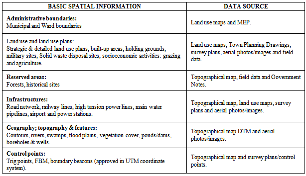
- Basic (spatial) environmental information needed in the GIS modeling process for EIA procedures were identified as shown in Table 1. The identified data (in brackets) were obtained from the following organizations: Shinyanga Municipal Council (Government Notes, MEP, survey plans, Land use maps and Town Planning Drawings); Ministry of Lands, Housing and Human Settlement Development (Topographical maps, survey plans/control points); and National Bureau of Standards (high resolution images); and Geo Network Limited (Digital Terrain Model).
|
2.2. Data Processing
- In this study, data processing involved data validation and data preparation.
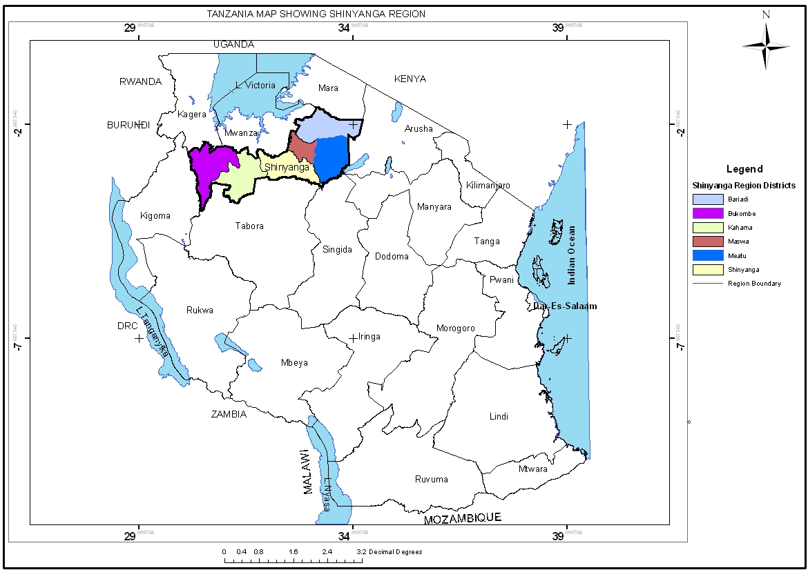 | Figure 1. Map of Tanzania Showing the Area of Study |
2.3. Modeling – the Approach and Structure Designed for EIA Procedures
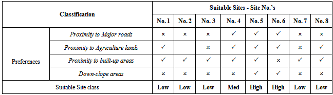
- The GIS modeling type adopted in this research is Suitability model which involves geo-processing operations on geographic features to prepare models for suitability and assessment of alternative scenario. Suitability assessment involved the application of suitability criteria (conditions and factors) identified to be required and/ or recommended in the process of assessing the suitability of the appropriate sewerage pond sites to prepare the suitability map.Suitability criteria included the Landscape factors and Classification conditions set to be applied for suitability analysis. The criteria were selected based on the environmental and engineering requirements for identification of suitable sites for sewerage ponds. Landscape factors were considered in ensuring efficient performance of the proposed natural sewerage pond systems. Generally, these factors are involved in assessing areas identified as environmentally permissible for sewerage pond. The landscape factors set to be applied in this research were: Topography; the slope of the proposed site should be less than or equal to (≤) 5%, and Area; the proposed site should be greater than or equal to (≥) 10 acres - approximately four hectares (4 Ha).Classification conditions are the key determinant conditions in the assessment of alternative scenario, (the alternative sites). The conditions were used to classify the suitable sites into three alternatives basing on the avoidance values; i.e. low, moderate and high avoidance value. The suitable sites were classified as:• High suitable class sites: high efficiency in pond performance with low construction and low operation costs.• Moderate suitable class sites: effective pond performance but high construction costs with low operation costs.• Low suitable class sites: serves low construction costs, having high operational costs to achieve efficient pond performance.
2.4. The GIS Based Model Structure
- The model’s overall structure is outlined in Figure 2. The model identifies the basic data set used in the processing steps of suitability analysis in determining suitable sites for sewerage pond.Referring to Figure 2; The Primary Maps section identifies the basic spatial datasets containing geographical information required for suitability analysis. The section include the Topographical maps, Land use maps, Digital (aerial) images, Survey plans, Coordinates and DTM datasets. Derived Maps is the next level of model abstraction which describes geographical features derived from primary maps using computer operations. The operations include various geo-processing operations such as on screen digitization and development of slope information. This section consisted of 27 derived criteria maps grouped into four categories: ESA, Land-uses (existing and planned), topography, and Infrastructures. The Interpreted Maps’ section refers to GIS modeling level which prescribe the proposed land use (decision-making) from the described information. These maps are the result of assessing for environmental and operational considerations in terms of the intended use. This group of ‘Interpreted Maps’ comprised of six category maps: Exclusion (identifying locations prohibited for sewerage pond systems including sensitive areas), Permissible lands (to a map locating areas accepted as environmentally permissible for sewerage pond systems), Slope, Proximity to major roads, Proximity to agriculture lands, and Proximity to built-up areas, that the best locations for the sewerage pond are, near existing roads, near agriculture lands, close to built-up/planned area, and on downstream areas with respect to planned residential zones. The final section of the model; Suitability Map is a composite of the set of interpreted maps. The overall suitability map relies on the suitable areas map and the resultant predefined possible intersections of the four preference maps. The preparation of the suitability map involves masking of the suitable class zones with the suitable areas to visualize any location that could contain a sewerage pond (except Exclusion), and if so, what is its relative goodness in terms of avoidance values; i.e. high suitable class, moderate suitable class, or low suitable class site.
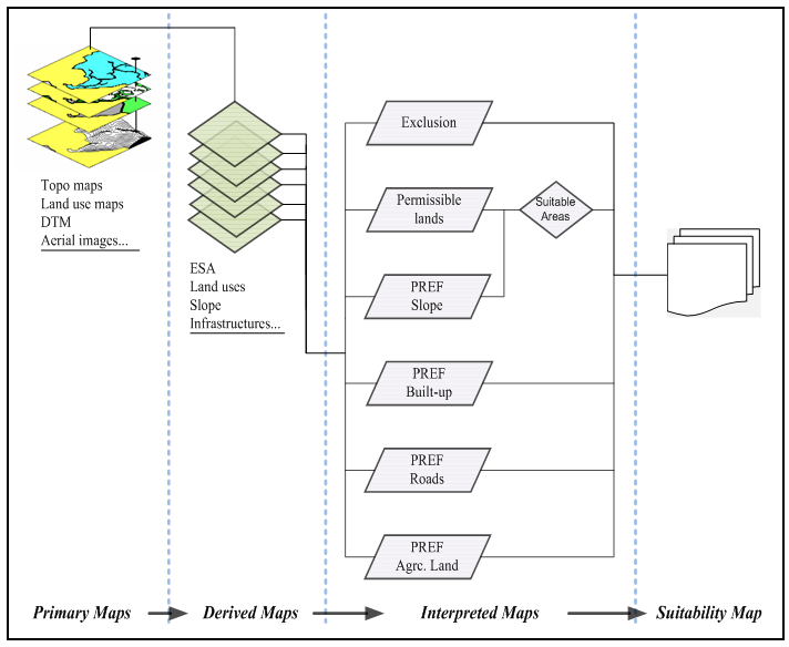 | Figure 2. The GIS-based Model Structure in Identifying Suitable Areas for WSP |
2.5. Identification of Environmentally Sensitive Areas (ESA)
- ESA are geographical (natural and man-made) features with high environmental value that need either protection or conservation or sustainable use of various elements o of the environment. According to the EIA Guidelines and Procedures provided by NEMC; five categories of ESA existing within the study area were identified:• Wetlands and water bodies: flood plains, swamps, rivers (permanent and seasonal), dams (natural and manmade) and water treatment plant.• Protected areas: forest reserves; National forest reserve and forest reserves guarded by laws of Local Government.• Recharge areas of aquifers: boreholes and shallow wells.• Prime agriculture lands: urban farms (planned) and local farming areas.• Burial sites and graves: included or allocated within neighborhood layouts; i.e. the detailed land use plans (Town Planning Drawings).
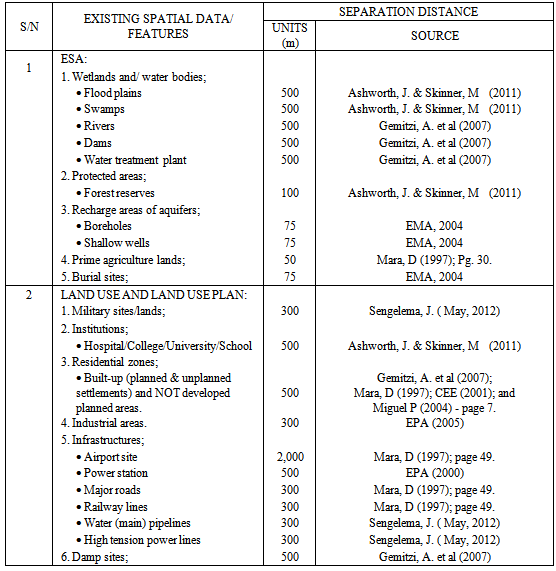
2.6. Setting out Acceptable Separation Distances (Buffering)
- In assigning buffer zones, considerations were taken with respect to the nature and behavior of the sewerage pond as a cause of several potential impacts on the environment such as contamination (soil, surface water and groundwater), pollution (odor), physical appearance (visual impact), attraction to birds (dangerous-in-nearby airports), etc. The distances (buffers) were adopted from several sources including written (published) documents. Table 2 identifies the adopted acceptable separation distances with respect to the sewerage pond site.
2.7. Conceptual Database Design
- Conceptual database design is a software and hardware independent process for creating a conceptual schema of an information system using a high level conceptual data model for the database (Elmasri & Navathe, 2000). This provided a concise description of user requirement, detailed description of the entity types, relations and constraints.IN this study the Entity Relationship (ER) model was used. This is one of several high-level, or semantic, data models used in database design. The goal was to create a simple description of the data that closely matches how users and developers think of the data[22]. This was achieved by constructing the entity relationship diagram (ERD) as the representation of the conceptual data model of the database in the graphic form.
2.8. Logical Database Design
- Logical database design converted the conceptual database design into a database schema; i.e. simplifying the conceptual design into logical manner. The process is software dependent but hardware independent. The aim was to convert the Entity Relation (ER) schema into a relational database schema; the result is a conceptual schema, sometimes called the logical schema, in the relational data model[22]. The ERD were translated into a collection of tables with associated constraints which resulted to the following relational tables:i. SMC boundary (BoundaryID, Boundary_Name, Area_Coverage, EstablishingGN_No)ii. Ward (WardID, Ward_Name, Area_Coverage)iii. Landuse distribution (LanduseID, Landuse_ Category, Entry date)iv. Landuse category (CategoryID, Landuse_Type, Landusetype_Name, LanduseID, Location, WardID, Status)v. ESA (ESAsID, ESA_Name, Entry date)vi. ESA features (FeatureID, Feature_Category, Local_Name, ESAsID, WardID, Status)
3. Results
3.1. The Geospatial Database
- The construction of the geospatial database, also known as the Shinyanga Municipal Environmental Management Information System - SMEIMS was realized by integrating the spatial component developed in ArcGIS with the non-spatial component developed in MS Access DBMS. Figure 3 conceptualizes the processes in developing the SMEMIS. The non spatial component of the geospatial database contains six relational tables namely: SMC boundary, wards, land uses, ESA categories, land use types and ESA features. The development of the spatial database based on the management of the vector-based geographic features prepared as individual layers. The layers were developed from coordinates, DTM and as well as from the scanned land use maps, aerial photos and topographical maps through onscreen digitization.
3.2. GIS-Modeling for EIA Based Site Selection Procedures
- In achieving the intended results, the EIA-based GIS modeling process was chained into two phases; phase one was the identification of permissible sites and the second phase involved preparation of suitable sites model.
3.2.1. Permissible Sites Selection Process
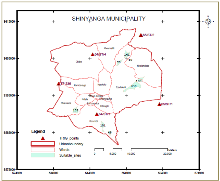
- This phase involved spatial data analyses in identifying permissible lands (Permissibility of land use refers to the awareness of the existing Municipal land use plan (Master/Strategic plan) during the site selection process. The concern is made to determine if the proposed land use is permissible on a particular site under the provisions of the local environmental plan, other planning instruments or government policy.Initially, the process located the restricted areas for sewerage pond systems, and then, defined the included areas (permissible lands) as one feature class out of the restricted areas. The included areas, initially as one feature, were converted to individual features each as a polygon representing a particular permissible region, all on one feature class layer – the Permissible lands (Figure4); The map identifies eight (8) permissible areas possible for sewerage pond systems.
3.2.2. Suitable Sites Model
- This phase involved the preparation and testing of the model to give the intended results - the final map that locates the classified permissible sites suitable for sewerage pond systems. The modeling, achieved through suitability analysis executed in two sequential operations: preparation of the model for suitability and the assessment for alternative scenario.Preparation of suitability model:Suitability model identifies all permissible lands which are suitable for sewerage pond systems, referred to as suitable sites. The identified permissible lands were analyzed to locate the regions within which they meet the landscape factors set, previously expressed as topography: slope ≤ 5% and site size: area ≥ 4 Ha. Figure 5.Assessment for alternative scenario:At this stage, all suitable sites were assessed basing on ‘avoidance values’ as per classification conditions to identify the ‘alternative sites’ into three categories: high, moderate and low suitable classes.Geographical patterns representing the ‘preferences’ were prepared that included: Prime agricultural lands, built-up areas and major roads layers were buffered to develop the three proximity-based preferences as feature class layers; i.e. proximity to prime agricultural lands, proximity to built-up areas and proximity to major roads. This resulted into patterns of the three proximity-based preferences are shown on Figure 6.
|
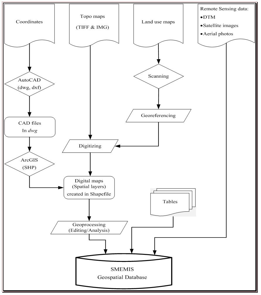 | Figure 3. Conceptual framework in building the Shinyanga Municipal Environmental Management Information System - Geospatial Database |
 | Figure 4. Permissible lands for sewerage pond systems |
|
3.3. Suitable Sites
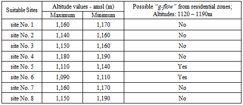
- Last was to assess the identified ‘suitable sites’ with the developed ‘class zones’ for alternative sites in terms of high, medium and low class suitable sites. The alternative sites were obtained through an overlay assessment of each class zone with the suitable sites layer. For all suitable sites intersected with (falling within) a particular class zone were identified and defined as suitable sites of that particular class; i.e. suitable sites coincide with high, medium or low class zone were considered as high, medium or low class suitable sites respectively. Table 4 prepared with generalizes the assessment results particularly in a situation whereby a suitable site is NOT wholly, BUT largely intersected with a class zone, the site was considered as it belongs to that particular class.Figure 8 is a resultant suitability map displaying the classified as high, moderate and low class permissible sites, suitable for sewerage pond systems within the study area.
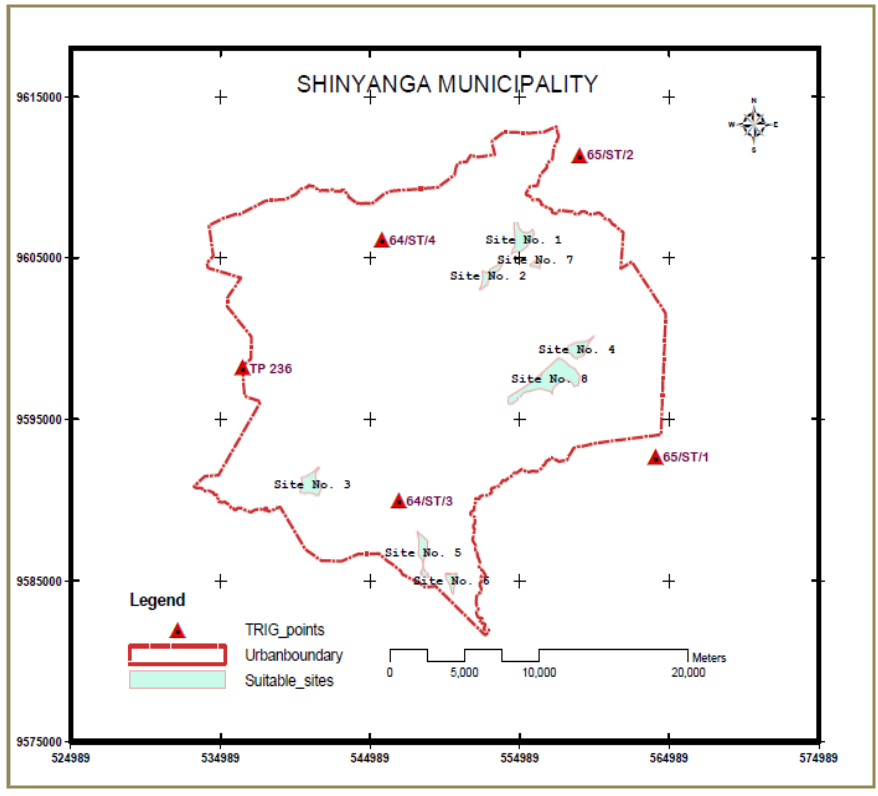 | Figure 5. Suitable sites for sewerage pond systems |
|
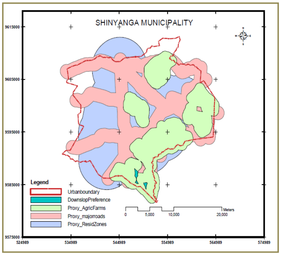 | Figure 6. Overlay display of the three proximity-based classification preferences |
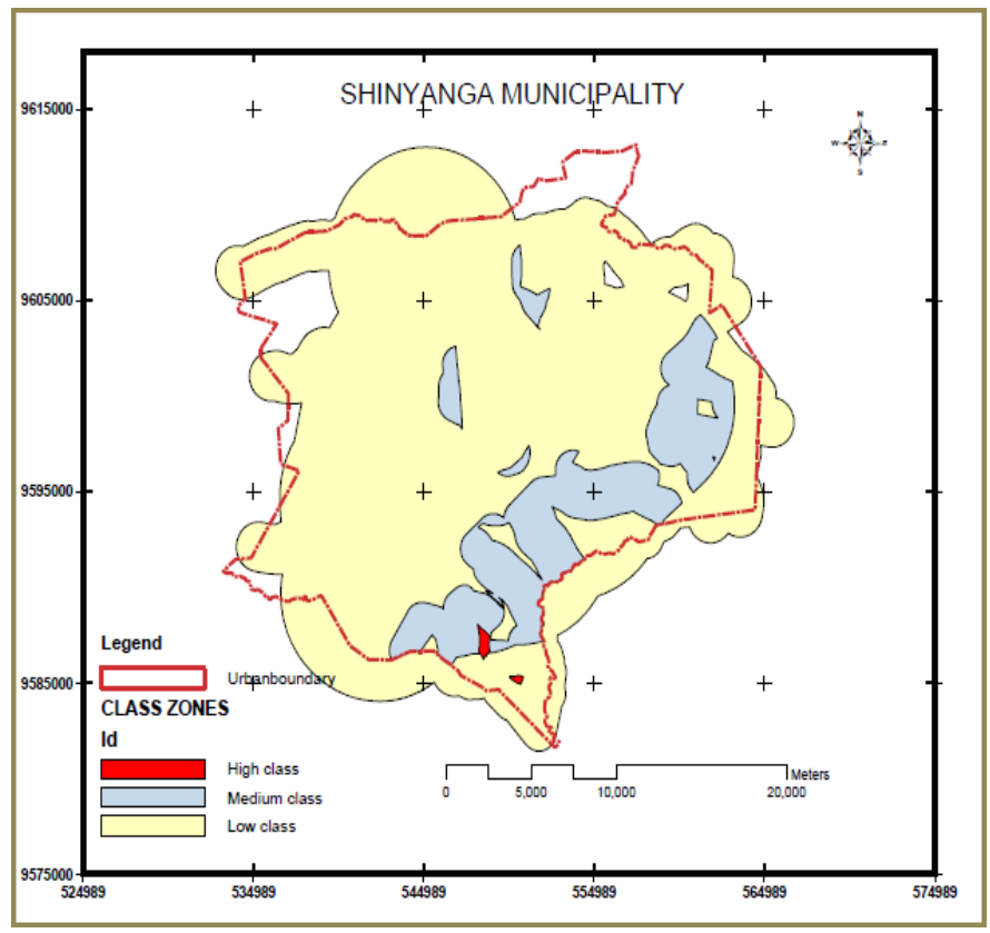 | Figure 7. The ‘suitable class zones’ identified within the area |
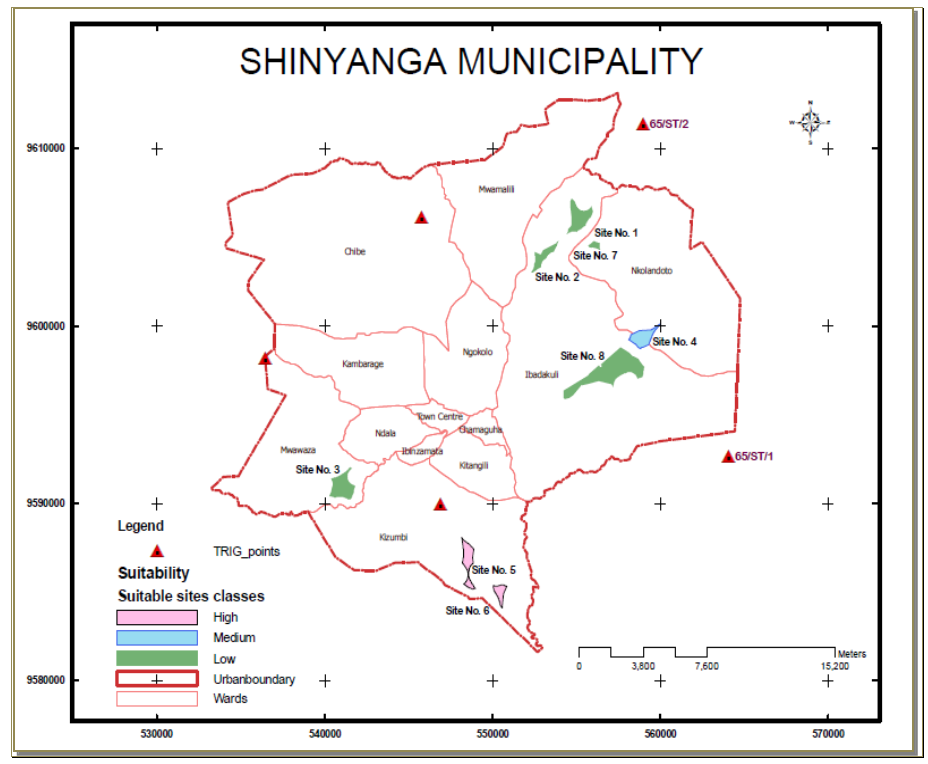 | Figure 8. Suitability map for sewerage pond sites within Shinyanga Municipality |
4. Conclusions
- The methodology followed in this study can be generalized for EPM process to facilitate various spatial analyses and management capabilities of an environmental decision support system in integrating and monitoring data to enhance solutions in other applications.Apart from the achieved functionality of the prepared geo-database in modeling the EIA procedures, the geo-database will also enhance the capacity of data handling, analysis and dissemination of the urban environmental information; as such, it will serve as a common source database with quality assurance/quality control on data (bases) sets, hence the centralized GIS system for EPM process as a unit. The unit as one central body responsible for maintaining the GIS system will serve as the core for effective and efficient urban planning and management activities. In this situation, most of the problems associated with the use of GIS for this purpose which affect the entire EIA system including the costs of start up, system maintenance, database construction and purchase of hardware and software, can be overcome. The study didn’t address the issues related to the policy level; the issues need further work. The study however, didn’t take into account the opinion of the local communities, which perhaps, plays the most important role in siting such facilities. But, It offers a quite simple, accurate and fast way to examine large areas at a master plan level, though the final decision, at the municipal level, should be based on more detailed examination on the identified sites.