-
Paper Information
- Paper Submission
-
Journal Information
- About This Journal
- Editorial Board
- Current Issue
- Archive
- Author Guidelines
- Contact Us
American Journal of Geographic Information System
p-ISSN: 2163-1131 e-ISSN: 2163-114X
2013; 2(1): 15-18
doi:10.5923/j.ajgis.20130201.03
A Study of Morphological Changes in the Coastal Areas and Offshore Islands of Bangladesh Using Remote Sensing
 Abstract
 Reference
 Full-Text PDF
 Full-text HTML
M. Shamsul Alam 1, Kabir Uddin 2
1Department of Geography & Environmental Studies University of Rajshahi, Rajshahi 6205, Bangladesh
2International Centre for Integrated Mountain Development, GPO Box 3226, Kathmandu, Nepal
Correspondence to: M. Shamsul Alam , Department of Geography & Environmental Studies University of Rajshahi, Rajshahi 6205, Bangladesh.
| Email: |  |
Copyright © 2012 Scientific & Academic Publishing. All Rights Reserved.
Bangladesh is a country where 80 percent of the land is below 1 meters from the MSL. The small country with a huge population is already known to the outside world for her vulnerability to natural hazards. Among the impacts of climate change, the serious concern for Bangladesh is the relative sea level rise (RSLR). A 45-centimeter sea level rise in Bangladesh may dislocate about 35 million people from 20 coastal districts by 2050. In a worst-case scenario, Bangladesh could lose nearly 25 percent of its 1989 land area by around 2100. The process of erosion, deposition and accretion are common phenomenon in the deltaic country. This study based on remote sensing data tries to examine the erosion, accretion and net gain/loss of land in the Coastal Areas and Offshore Islands of Bangladesh and recommends measures to enhance the process of accretion to save millions from becoming environmental refugees.
Keywords: Bangladesh, IPCC, Hydro-Geomorphology, Erosion, Accretion
Cite this paper: M. Shamsul Alam , Kabir Uddin , A Study of Morphological Changes in the Coastal Areas and Offshore Islands of Bangladesh Using Remote Sensing, American Journal of Geographic Information System, Vol. 2 No. 1, 2013, pp. 15-18. doi: 10.5923/j.ajgis.20130201.03.
Article Outline
1. Introduction
- Located in the South Asian Region between 21°N to 26°30'N and 88°E to 92°30'E Bangladesh (Figure 1), a small densely populated country known to the outside world for frequent natural hazards that takes lives and property almost every year. The country is a low-lying delta, formed by the dense network of the distributaries of the mighty Ganges- Brahmaputra- Meghna (GBM) , between the Himalayas and the Bay of Bengal. The total land area is 147,570 sq. km1 and consists mostly of low and flat land, with some hilly areas in the northeast and southeast. A network of more than 230 major rivers and their tributaries criss-crosses the country. With an average elevation of 4 to 5 meters above mean sea level (MSL), nearly a third of the country is susceptible to tidal inundation and nearly 70% gets flooded during heavy monsoons. About 10% of the country is only 1 meter above the mean sea level, and one-third is under tidal excursions. The country has a population of about 150 million 5 With over 1000 people per sq. km., one of the highest population densities in the world. When the country is achieving success in meeting her multi-dimensional problems in addition to natural hazards, the IPPC's prediction of Climate Change and its impacts has added a further dimension of concern to the people and government of the country as well as the world community. Among the impacts of climate change as predicted by the IPCC, the serious concern for Bangladesh is the relative sea level rise (RSLR). Sea level rise is projected for Bangladesh, although there is disagreement on what the degree of sea level will be-the IPCC Fourth Assessment gives a global average sea-level rise over the second half of the 20th century was 1.8 ± 0.3 mm/yr, and the order of 2 to 3 mm/yr is considered likely during the early 21st century[1]. It has also been predicted that the RSLR is expected to displace 20 million environmental refugees; 32 percent and 8 percent loss of rice and wheat production respectively. Certainly these are a matter of serious concern to the people and government of country as well as the world community. A 45-centimeter sea level rise in Bangladesh may dislocate about 35 million million people from 20 coastal districts by 2050[2]. Organization for Economic Cooperation and Development (OECD, 2003) study suggested that 1 (one) meter rise in sea level would inundate 18% of Bangladesh’s total land mass which will ultimately turns the whole southern region into a sea[3]. In a worst-case scenario, Bangladesh could lose nearly 25 percent of its 1989 land area by around 2100[4] .Projected sea-level rise could flood the residence of millions of people living in the low lying areas of South, South-East and East Asia such as in Vietnam, Bangladesh, India and China[2,5].In the backdrop of such a situation this study endevours to examine the recent morphological changes due to land erosion versus accretion in the coastal areas and offshore island of Bangladesh based on remote sensing (RS) data and other relevant research evidences of RSLR in the Northern Indian Ocean, especially the Bay of Bengal and suggest measures to accelerate the coastal accretion process in protecting people from becoming environmental refuges.
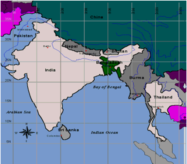 | Figure 1. Location of Bangladesh |
2. Methodology
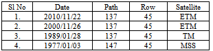
- Based on satellite image quality and availability, the primary data used were MSS, TM and ETM+ sensor of Landsat satellite for four different years. Table 1 shows the list of satellite imagery. The enumeration of the coastal belt and associate land cover was derived in steps. Images were processed in eCognition Developer 8.7 software for object-based image analysis (OBIA). All the scene of Landsat images were not acquired as rectified image. Topographic maps, Landsat MSS and TM image were georeferenced to UTM and Zone 46 projection based on generated Ground Control Points (GCP) from Landsat ETM+(2000) image. All images were resampled with the nearest neighbour method to a common resolution of 30m. After that Landsat images were processed in Cognition / Definiens software for object-based image analysis (OBIA). The fundamental step of eCognition image analysis is a segmentation of a scene. Multiresolution segmentations were used for object-based image analysis. Multiresolution Segmentation groups areas of similar pixel values into objects. Consequently homogeneous areas result in larger objects, heterogeneous areas in smaller ones. A convenient approach was used to run segmentations with different parameters until the result was satisfactory. For each segment, information on average Land and Water Mask has been derived. These information was used to develop suitable classification algorithms for individual classes. Image objects were linked to class objects and each classification link stored the membership value of the image object to the linked class. With each polygon assigned rules to a specific class, land cover map including river channel was generated for coastal zone of Bangladesh. The classified data was exported to ArcGIS and morphological changes have been analyzed following ordinary procedures.
|
3. Results and Discussion
- Results of the morphological changes in the coastal areas and offshore islands of Bangladesh indicate more accretion than erosion of land (Table 2 and Figures 3) during 1977-2010 period. The results of the morphological changes during the 34 year period in the coastal areas of Bangladesh shows net gain of 139 square Kilometers of land counterbalancing the predicted submergence due to RSLR. The eastern side shows erosion while the south and southwestern coastal region shows more accretion.The first author was a member of the survey team that surveyed the newly accreted island of 'Nijhum Deep' (Silent Island located between 22 0 -220 03.0’ N and 91 0 0’ E is an offshore island in the Bay of Bengal situated in the extreme south of Hatiya island which is separated by Hatiya channel which came in surface in 1972) in January 1977. At that time the team had to travel from Jahajmara to the island in shallow water (a distance of 10 kilometers) by sea truck. In 2005 another team of the Department of Geography & Environmental Studies of the University of Rajshahi visited the same island when they travelled from point to the island by land. This is a real-time example of the accretion going in the coastal areas and offshore islands of the country.
|
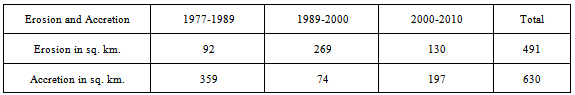
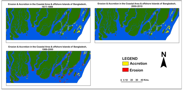 | Figure 2. Erosion and Accretion in the Coastal Areas of Bangladesh, 1977-2010 period |
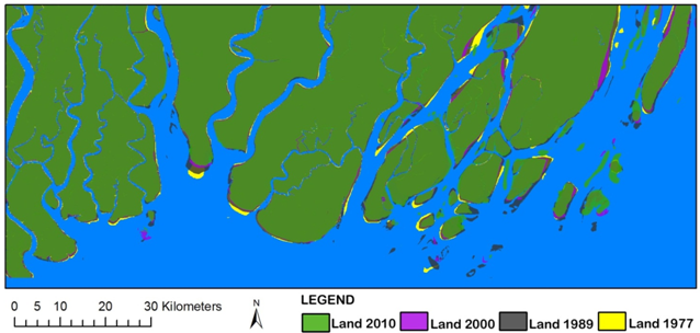 | Figure 3. Morphological Changes in the Coastal Areas of Bangladesh, 1977-2010 |
4. Government Initiatives
- Bangladesh reclaimed 1,000 square kilometers of new land in the Meghna estuary by building two dams in 1957 and 1964. Despite the success, the reclamation process was halted due to lack of donor financing. The Government of Bangladesh (GoB) has been pursuing a number of projects in the coastal areas of Bangladesh since 1977 to address the problems of coastal floods & tidal surges; erosion and accretion of coastal areas. Land Reclamation Project (LRP), Meghna Estuary Studies (MES), Coastal Embankment Rehabilitation Project (CERP), Delta Development Project (DDP); Char Development and Settlement Projects (CDSP), Integrated Coastal Zone Management Project (ICZMP), Estuary Development Programme (EDP) etc. are some of the GoB’s coastal initiatives.
5. Recommendations and Conclusions
- In the advent of the above context a proper management plan should be undertaken to save the coastal areas of Bangladesh from submerging. Such plan should begin with the understanding of the complex processes involved in delta building, especially the sediment dispersal mechanism in the Sundarban delta. The following recommendation can be made to arrest erosion and help accretion in the coastal belt of the country. ● Undertake research to understand the complex delta process in the GBM delta and response of this mangrove to RSLR.● Plugging of the breaches and strengthen the polders along the coastal belt and design hydraulic engineering projects to arrest erosion and accelerate accretion. ● Bring the shrimp culture near the Sundarban under planned scheme of not disturbing the natural sedimentation process. ● Develop tools of prediction of morphological changes in response to the RSLR.● Monitor of the morphological changes.● Enhance the afforestation programme along the coastal belt, especially in the Sundarban to help both acceleration of land stabilisation of char lands[12] The process of land accretion in the coastal area and offshore islands of Bangladesh poses a serious question on the predictions of the IPCC regarding the impacts of climate change and RSLR in Bangladesh. Efforts to enhance the process of land accretion in the coastal area and offshore islands of Bangladesh should be strengthened to save millions from drowning. At the same time research for comprehensive understanding of the Bengal delta building process should also be undertaken.