-
Paper Information
- Paper Submission
-
Journal Information
- About This Journal
- Editorial Board
- Current Issue
- Archive
- Author Guidelines
- Contact Us
American Journal of Environmental Engineering
p-ISSN: 2166-4633 e-ISSN: 2166-465X
2020; 10(1): 13-19
doi:10.5923/j.ajee.20201001.03

Geological Assessment of Landslide Occurences in Okemesi Area, Southwestern Nigeria
 Abstract
 Reference
 Full-Text PDF
 Full-text HTML
Ayodele O. S.1, Olayanju G. M.2, Adeosun O. E.1
1Applied Geology Department, Federal University of Technology Akure, Nigeria
2Applied Geophysics Department, Federal University of Technology Akure, Nigeria
Correspondence to: Ayodele O. S., Applied Geology Department, Federal University of Technology Akure, Nigeria.
| Email: |  |
Copyright © 2020 The Author(s). Published by Scientific & Academic Publishing.
This work is licensed under the Creative Commons Attribution International License (CC BY).
http://creativecommons.org/licenses/by/4.0/

Landslide occurrence in Okemesi, an ancient town in the southwestern Nigeria on 24th of September 2017 was the third in the last two decades that led to loss of properties worth millions of Naira. This paper presents a geological investigation and quantitative modelling of the topographic surface of the area of landslide occurrence with the view of identifying the factors responsible for the land failure mechanism. The investigation included reconnaissance survey, geological mapping of the area to determine the underlying lithologic units, systematic sampling of soils and rocks at the affected sites at a sampling interval of 100 m, determination of geotechnical properties of the soils and rocks as well as Atterberg limits. Index and engineering properties of the soils such as load bearing capacities of the rocks and soils, repose angles and specific gravity were determined in the laboratory. The result of geotechnical analysis revealed that the soils are predominantly sandy clay with clay content ranging from 9.0 - 24.6%, sand content 60.2 – 70.6%, and silt content 13.5- 24.6% respectively. The soils were classified as poorly graded on basis of the unified soil classification system with specific gravity ranging from 2.640 - 2.690. Laboratory estimated repose angles also range from 28.20 – 38.280, which indicated that analyzed soils showed high level of instability This can be attributed to the major damage caused by the slump at the toe and lower section of the slope during the 2017 landslide. It is therefore pertinent that the settlers be relocated to away from the schistose quartzitic hill to avoid loss of lives in future that might arise from possible reactivated landslide.
Keywords: Okemesi, Landslide, Angle of Repose, Geotechnical properties, Rocks, Soil
Cite this paper: Ayodele O. S., Olayanju G. M., Adeosun O. E., Geological Assessment of Landslide Occurences in Okemesi Area, Southwestern Nigeria, American Journal of Environmental Engineering, Vol. 10 No. 1, 2020, pp. 13-19. doi: 10.5923/j.ajee.20201001.03.
Article Outline
1. Introduction
- Alongside avalanche, landslide can be ranked as one of the natural disasters having high impact on humanity. In most cases, it occurs as landslip, slope failure or slump, which is an uncontrollable downhill flow of rock, earth, debris or the combination of the three. Landslides are among many disasters causing massive destructions and loss of lives and properties across the globe. A landslide can be defined as the movement of a mass of rock, debris, or earth down a slope. It is the collapse of a mass of earth or rock from a mountain or cliff. The mechanisms of rainfall-induced landslides have been extensively studied and some of the conclusions assert that the amount of rain, nature of slope-material, geology, discontinuities and weathering are the major factors predisposing a slope to failure ([9], [11], [12], [14] & [15]). The steepest angle at which the sloping surface of loose materials is stable is called the angle of repose. At this angle, the material on the slope face is on the verge of sliding. When the ground becomes saturated, it can become unstable, losing its equilibrium in the long run, which is when a landslide breaks loose. Other causes include factors that increase the effects of down-slope forces and factors that contribute to low or reduced strength. Much of the damage, according to Brabb (1989) [6] is masked by association with more spectacular events, such as earthquakes, volcanic eruptions, hurricanes, and floods. Landslide occurrences have been reported in various parts of Nigeria. This paper investigates the recurrent landslides in the area by determining the geotechnical properties of the soils and relate them to the geology of the area in order to identify plausible causes of the recurrent landslides in the area.
2. Study Area
- Agbona hill in Okemesi where the incident occurred lies within latitudes 7° 49' 0" N to7° 52' 30" N and longitudes 4° 53' 0" E to 4° 56' 30" E with a total surface area of 24km² (Figure 1). It lies in the eastern part of the Ilesha N.E topographical sheet No. 243 acquired at a scale of 1:50,000. The landslide occurred in two areas but only a part was quite accessible unlike the other parts which is thickly vegetated, steep and rugged thereby making accessibility difficult. There is prevalence of gully erosion along hill slopes and valleys while the drainage patterns of the study area are dendritic & Trellis.
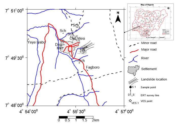 | Figure 1. Map of the study area |
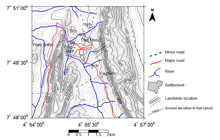 | Figure 2. Topographic map of the study area |
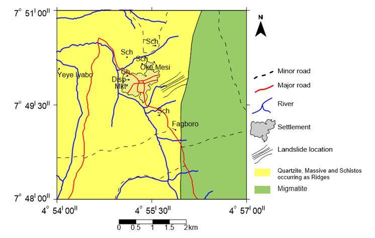 | Figure 3. Geologic Map of the Study area (After Ayodele, 2018) |
3. Methods
- The method of study adopted for this research involved geologic field mapping and laboratory investigation. The field mapping exercise was carried out shortly after the event occurred. During the mapping, information on the landslides was gathered from eye witnesses. Geological mapping of the area was carried out to determine the nature of the rocks, the geological and environmental factors that must have caused the landslides and a special attention was paid to the rock types, fractures and human activities along the slope toe of the hill and types and sizes of the materials moved. Prior to the geological mapping exercise, aerial photographs taken in the 1970s and 80s and topographic maps of Okemesi-Ekiti, Sheet 244 Southeast and Southwest, on a scale of 1:50,000 were evaluated. The nature and amount of destruction to lives and property were recorded. A total of twenty (20) samples were collected from the study sites consisting both soil and rock samples (figure 4). The rock samples were collected at an interval of 100m and labeled before it was packed into the sample bag. Physical characteristics of the rocks such as color, textures and various features were recorded. The soil samples were collected at a depth of 1m and later subjected to index and strength tests to determine their geotechnical properties.
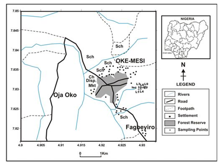 | Figure 4. Map of the study area showing sampling points of rocks and soils |
4. Results, Interpretations and Discussions
- ResultsAn eye witness account revealed that landslides occurred on the 24th September, 2017 in the morning between the hours of 1:00 am and 6:00 am after a torrential rain that lasted for three consecutive days. The sliding was accompanied by loud explosions and vibration that was felt in the surroundings. According to him, no life was lost but buildings were affected by the large boulders that were sliding towards the toe of the hill (Figures 5 & 6). The summary of geotechnical results is presented in table 1.
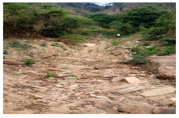 | Figure 5. Photograph of steep slopes that facilitated the movement of material down slopes |
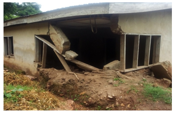 | Figure 6. Field Photograph of damaged building caused by the landslide |
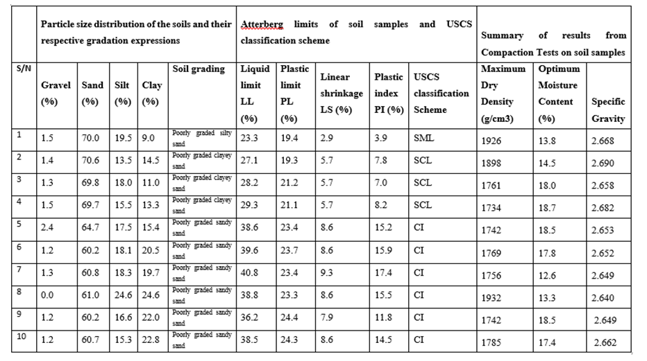 | Table 1. The summary of geotechnical results |
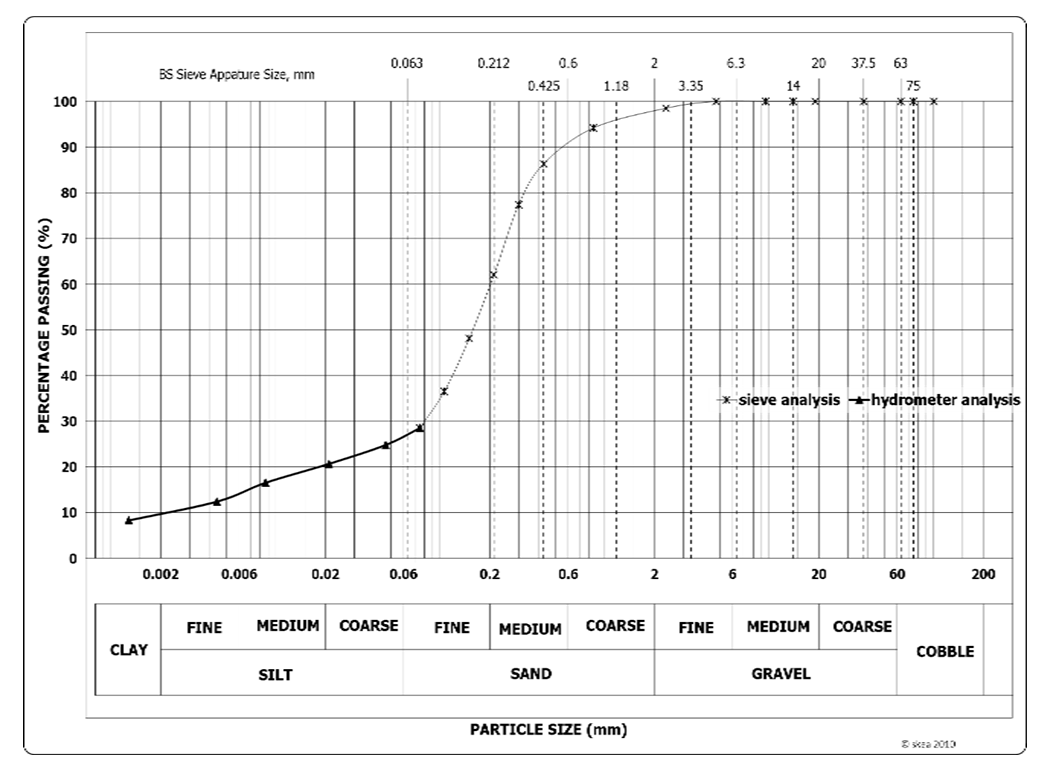 | Figure 7. A typical grain size distribution curve of the study area |
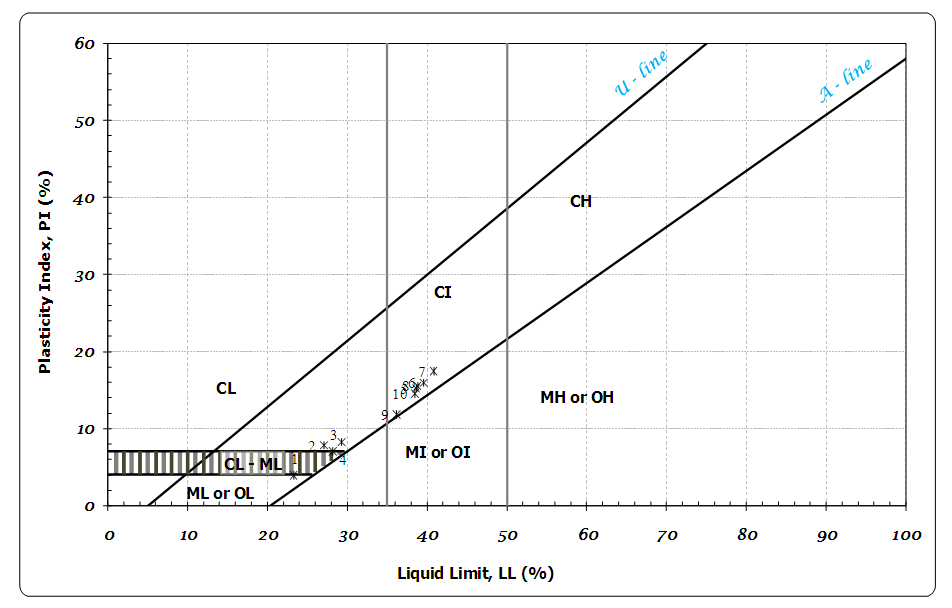 | Figure 8. A typical cassagrande curve generated from the study soil |
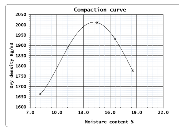 | Figure 9. A typical compaction curve for the soil samples |
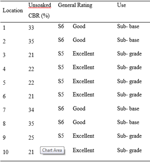 | Table 2. Rating of Soils Underlying the Study Area for use as subgrade, sub-base and base materials in road and airfield construction employing FMW&H rating |
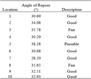 | Table 3. Classification of powder flowability based on angle of repose |
5. Conclusions and Recommendations
- Geological study as seen during the field mapping of the affected area shows that the rocks in the studied area has been intensely fractured. This has contributed to the occurrence of the landslide.From the geotechnical properties of the soil samples analyzed the soil samples collected showed more susceptibility to landslide or slope failure. Remedial measure for earth slope stabilization includes reducing the height of the slope loading at the toe of the slope, benching, fattening or reducing the slope angle etc. The slopes should be improved on by methods like; drainage control, and slope flattening. The latter reduces the weight of the mass tending to slide, providing a support below the toe and this support also increases the resistance to sliding and hence increases the stability. Also, grouting and injection of cementing materials into weak zones also help in stability. This highlights the need for more rigorous analysis of the soil and subsequent adoption of appropriate prevention techniques. The mitigation method does not help in avoiding the landslide but helps to reduce the loss of life and damage to the property that can be caused due to the landslides. Excavation activities should be avoided in regions that are highly susceptible to landslide or slope instability since that might trigger larger landslide especially in soft clays. In regions that are less susceptible to land slide the strengthening of slopes can be carried out with the help of plastic mesh reinforcement, proper drainage networks, check dams, constructing retaining walls, gabion walls etc. Providing vegetation on the slopes and other biotechnical slope protection methods like using geonets, planting vetiver etc. also helps in reducing the landslides.Based on the findings of this research work, the following recommendations are made. (i) Excavation activities should be avoided in regions that are highly susceptible to landslide or slope instability since that might trigger larger landslide in the area. (ii) In regions that are less susceptible to landslide the strengthening of slopes can be carried out with the help of plastic mesh reinforcement, proper drainage networks, check dams, constructing retaining walls, gabion walls etc. (iii) Providing vegetation on the slopes and other biotechnical slope protection methods like using geonets, planting vetiver etc. also helps in reducing the landslides. (iv) Reforestation with deep rooted trees and planting trees in rows would help in reducing the landslides by enhancing stability.