-
Paper Information
- Paper Submission
-
Journal Information
- About This Journal
- Editorial Board
- Current Issue
- Archive
- Author Guidelines
- Contact Us
American Journal of Environmental Engineering
p-ISSN: 2166-4633 e-ISSN: 2166-465X
2017; 7(4): 82-92
doi:10.5923/j.ajee.20170704.02

Geospatial Analysis of the Impact of Urban Built-up Development on the Distribution of Suitable Solid Waste Dumpsites in Ile-Ife, Nigeria
 Abstract
 Reference
 Full-Text PDF
 Full-text HTML
Eneche Patrick Samson Udama1, Nwosu Eberechi Ethel2, Abu Hassan Onimisi1
1Department of Geography and Environmental Studies, Kogi State University, Anyigba, Nigeria
2Department of Photogrammetry and Remote Sensing, Regional Centre for Training in Aerospace Surveys (RECTAS), Ile-Ife, Nigeria
Correspondence to: Eneche Patrick Samson Udama, Department of Geography and Environmental Studies, Kogi State University, Anyigba, Nigeria.
| Email: |  |
Copyright © 2017 Scientific & Academic Publishing. All Rights Reserved.
This work is licensed under the Creative Commons Attribution International License (CC BY).
http://creativecommons.org/licenses/by/4.0/

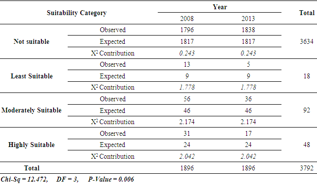
The implication of rapid urban built-up development on the siting of suitable solid waste dumpsites in Ile-Ife forms the major thrust of this paper. This study made use of different parameters to identify suitable solid waste dumpsites in Ile-Ife for 2008 and 2013 and determined the spatial growth of urban built-up development for the same epoch. Landsat ETM+ imageries for 2008 and 2013, Google Earth Pro Scenes, ASTER GDEM elevation data, as well as geologic and soil maps were obtained and analysed in. Erdas Imagine 9.2, ArcGIS 10.5 and Minitab 17.0 environments. Classification and extraction of geospatial data earmarked for the study, including road, water body, soil, underlying geology and slope were performed with the aid of simple model builders, Multi-Criteria Evaluation (MCE) analysis and Chi-square statistic. The result revealed that Ile-Ife town had a frequency of change in urban built-up area of about 1.91sq.km per year and experienced a reduction of moderately and highly suitable solid waste dumpsites and an increase in unsuitable ones. The Chi-square result (P-value = 0.006; -level of 0.05) revealed a significant difference in dumpsites suitability categories for the period under investigation. It was therefore concluded that in view of sustainable urban development, there is need for restrictions to be given for urban built-up development as it affects the limited areas suitable for waste disposal in Ile-Ife. The study also proved the flexibility of smart geospatial techniques (by which future scenarios can be predicted or simulated), thus recommended for environmental managers and urban planners.
Keywords: Multi-Criteria Analysis, Solid waste dumpsite, Suitability, Model
Cite this paper: Eneche Patrick Samson Udama, Nwosu Eberechi Ethel, Abu Hassan Onimisi, Geospatial Analysis of the Impact of Urban Built-up Development on the Distribution of Suitable Solid Waste Dumpsites in Ile-Ife, Nigeria, American Journal of Environmental Engineering, Vol. 7 No. 4, 2017, pp. 82-92. doi: 10.5923/j.ajee.20170704.02.
Article Outline
1. Introduction
- Waste management is a global environmental issue which constitutes a high significant level of hazard in most of the world’s cities today. Solid waste is the term used to describe non-liquid waste materials arising from domestic, trade, commercial, agricultural, industrial activities and from public services (Aibor and Olorunda 2006; Butu, Ageda, & Bichi 2013). Man, in an attempt to satisfy his daily needs, engages in the production of goods and services and in this process waste is naturally generated (Petts 2000; Smith et al. 2001). Solid waste generation is experiencing a rapid increase all over the world as a result of continuous economic growth, urbanization and industrialization. When left unattended to for a long time, solid wastes can constitute serious health hazards, causes offensive, foul odour or smell, pollute underground water sources and decrease aesthetics and quality of the environment (Uwadugu, 2003). This is even more difficult for environmental scientists as urbanization or urban sprawl as the case may be do not follow any particular, defined path or politico-administrative boundary (Bloch, et al 2015; Musa, Nnodu, & Eneche, 2016). Dump sites are historically the most used method for solid waste disposal in the world and has the longest history, the widest range of capabilities and in most instances, is the least expensive waste disposal method (Weiss, 1974; Khorram, et al. 2015). Most of the existing solid waste disposal sites in developing countries are open dumps even as the technology for proper sanitary landfill practice is not totally implemented (Weiss 1974; Petts, 2000; Lee and Krieger 1990; Toyobo, Baba & Oyeniyi, 2004; Nas et al. 2010; Suman 2012). It is expected that suitable disposal site must follow environmental safety criteria and attributes that will enable the wastes generated to be isolated so that there will be minimal risk to people or to the environment. Arimah and Adinu (1995) observed that location of dumpsites in urban areas will be beneficial to the urban dwellers because they will help to provide the most efficient and safe means of disposing the waste generated. However, the perceived environmental costs (e.g. air, water and land pollution and/or degradation), health-related hazards (such as cholera, typhoid, gastro enteritis, etc.), social and economic impacts associated, waste dumpsite are often confined to the immediate zone of influence of dumpsites and extends up to few kilometres (Tammemagi, 1999; Smith, Brown, Ogilvie, & Rushton, 2001; Chang, 2013; Anukwonke, 2014).In Nigeria, rapid urban growth since the 1960s have led to an increase in population of different cities thereby putting pressure on land resources, especially within urban and peri-urban areas, and this has led to an increase in solid waste generated in such areas (Hauwa, 2003; Uwadugu, 2003; Adetunji, Atomode, & Isah, 2015). Different studies in Nigeria have shown that solid waste generated from increasing number of persons in urban areas have deleterious effects if not carefully or properly handled. The study carried out by Uwadugu (2003) and Adetunji, Atomode, & Isah (2015) in Lokoja Metropolis, Kogi State, an area currently experiencing rapid urbanization as noted by Ifatimehin, Essoka and Ahmed (2012), is an area where solid waste generated are usually left for months on the streets before they are cleared, creating foul odour and breeding grounds for rodents and pathogens etc. Odjugo and Konyeme (2008) equally revealed in their studies the significant impact of urbanization on the quality of Ikpoba River in Benin City. Butu, Ageda and Bichi (2013) also studied the temporary roadside disposal of municipal solid waste in Karu, Nasarawa State and how it caused serious physical nuisance, aesthetic distortion and the proliferation of hideouts for rodents and snakes. Anukwonke (2014) revealed in his work that the pollution of groundwater in Onitsha, Anambra State from sampling fifteen (15), was due to little or no treatment of solid waste. These are issues that must be well-injected into any sustainable urban development strategy, to ensure the siting of suitable waste dumpsites at all time. This is the reason why the extent to which urban built-up space or land use type acts as a crucial component for considering the siting of solid waste dumpsites in any given area cannot be overemphasized. Recently, the process for locating suitable solid waste dumpsites have been more extensive and objective especially with the use of Geographic Information System (GIS) as a tool for selecting dumpsites and criteria, for example proximity to built-up areas, access road, waterbodies, and critical facilities; underlying geology, slope; economic value of land; direction of wind; etc. (Dorhofer & Siebert, 1998; Eastman 2012; Chang 2013). From this perspective, solid waste dumpsite selection can be seen as a Multiple Criteria Decision-Making (MCDM) problem as pointed out by Dursun et al. (2011) and Babalola and Busu (2011). There are however, several techniques for the selection of suitable solid waste dumpsites as adopted by different authors. The most common ones are the combination of Analytical Hierarchy Process (AHP) with GIS (Onut & Soner, 2008), the use of Analytic Network Process (ANP) (Afzali, et al., 2014), Fuzzy Logic and GIS (Khorram, et al., 2015) and the use of Intelligent systems (Al-Jarrah and Abu-Qdais, 2006). On the other hand, GIS has also been used in different studies for assessing the dynamics of land use/land cover, especially for urban land uses (Dimyati et al 1996; Balogun et al 2011; Ifatimehin et al 2012; Ajala and Olayiwola 2013; Du et al., 2014; Rawat and Kumar, 2015). The study of Ajala and Olayiwola (2013) on the growth and development pattern of Ile-Ife over a period of 21 years revealed a 2.95km2 land consumption rate and a 350% of change. Urbanization, therefore, which remains a global force to be reckoned with, gives an underlying basis that apart from the identification of suitable sites for waste disposal their update are necessary but the periods for this have not been farfetched, especially in Ile-Ife. In line with the findings of aforementioned authors, this research was carried out with the objective to establish the implication of urban land use dynamics (over a 5-year period) on the areas suitable for the location of solid waste dumpsites in Ile-Ife. Osun State, Nigeria. This was achieved by identifying critical parameters necessary for the selection of suitable solid waste dumpsites from existing literature, extraction of built-up land use/cover (LU/C) from satellite imageries, identification of suitable solid waste dumpsites for 2008 and 2013 and the significance of their spatio-temporal changes.
2. Study Area
- Ile-Ife is located within Latitude 7°26'N and 7°32'N and within Longitude 4°29'E and 4°35'E, covering an area of about 1,894Km2 in the present day Osun State. Ile-Ife consists of four Local Government Areas (Ife Central, Ife South, Ife East and Ife North). Two of these, Ife Central and Ife East, are located within Ile-Ife Township and have a population of 501,952 (Ajala & Olayiwola, 2013). See Figure 1.
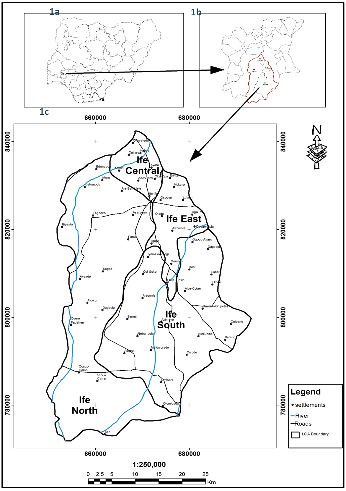 | Figure 1. Map of the Study Area. 1a: Map of Nigeria showing Osun State; 1b: Map of Osun State showing Ile-Ife; 1c: Map of Ile-Ife |
3. Materials and Method
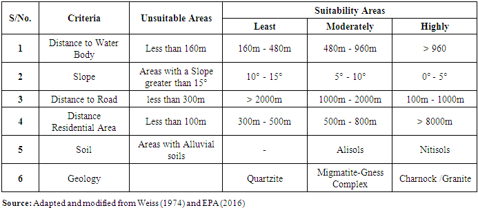
- The study made use of secondary data which contain both spatial and non-spatial data, complemented with detailed groundtruthing. A GIS-based logical methodology was adopted for this investigation with the use of Multi-Criteria Analysis (MCA). The MCA according to Chang (2013) combines a set of criteria to achieve a single composite map or base for making decision in line with any set objective, in this case, identification of suitable solid waste dumpsites in Ile-Ife. As observed by different authors (Dorhofer and Siebert 1998; Abessi and Saeedi 2009; Nas et al. 2010; Babalola & Busu, 2011; Eastman, 2012; Suman, 2012; Chang, 2013), there are numerous criteria used in the mapping of suitable waste dumpsites in any geographic area, however, this study only considered land slope, proximity to waterbody, built-up areas, and road as well as the underlying geology and soil of the study area, briefly explained.a. Underlying Geology: In the siting of waste dumpsites, groundwater contamination issues are a major concern, hence the geologic characteristics of a site are important. A key factor in decreasing the potential for contamination is the geomorphic characteristics or subsurface geology of the area. Earth material with low hydraulic conductivity, low effective porosity, and high retention of hazardous solutes are ideal for dumpsite locations (Dorhofer & Siebert, 1998; Ozeair and Mohsen, 2009).b. Proximity to Water Sources: Dumpsites create noxious gases and leakage that make them unsuitable to be in close proximity to surface waters (Dorhofer & Siebert, 1998; Nas, et al., 2010). If any landfill site were to leak waste-related chemicals into surrounding water, streams, or reservoirs, contamination would occur. The result would be the transfer of hazardous chemicals into drinking water, where reagents such as viruses and toxins could develop. Buffer analysis was therefore performed to realize this as carried out by Abessi and Saeedi (2009).c. Land-Use: Public acceptance of unwanted facility siting vary with land-use (Baban & Flannagan, 1998). Land-use of lowest value in public opinion reduces conflict over higher valued land-uses. But again, it is expected that dumpsites be located at areas far from human habitation, even recreational areas and open spaces. Hence, the study made use of the maximum likelihood classification algorithm to map-out built-up areas from the Landsat images of 2008 and 2013 – these served as major inputs in the study workflow.d. Slope: Slope which refers to the measures of the rate of change of elevation at a surface location is an important criteria as a steep slopes makes it difficult and costly to construct dumpsites since higher slopes would increase runoff of pollutants from the dumpsite, and thereby contaminate areas further away from such sites (Chang, 2013). e. Soil Properties: Certain soil characteristics promote a safer and more economically feasible implementation and operation of dumpsite. Permeability, effective porosity, and workability are important soil considerations (Atkinson et al., 1995). Soils with high silt and clay fractions provide groundwater protection and are an economically cheaper means to construct a dumpsite. Dorhofer & Siebert (1998) emphasized that if clay is not available at a location, it must be hauled to the site or substituted with a geo-synthetic system to maintain water quality levels.Thus the method employed in this study involved, first, land use land cover classification from which built-up land use types were extracted for two different years (2008 and 2013) and subsequent extraction of other important criteria for siting solid waste dumpsites as hitherto described. See Figure 2 for the workflow adopted in this study.
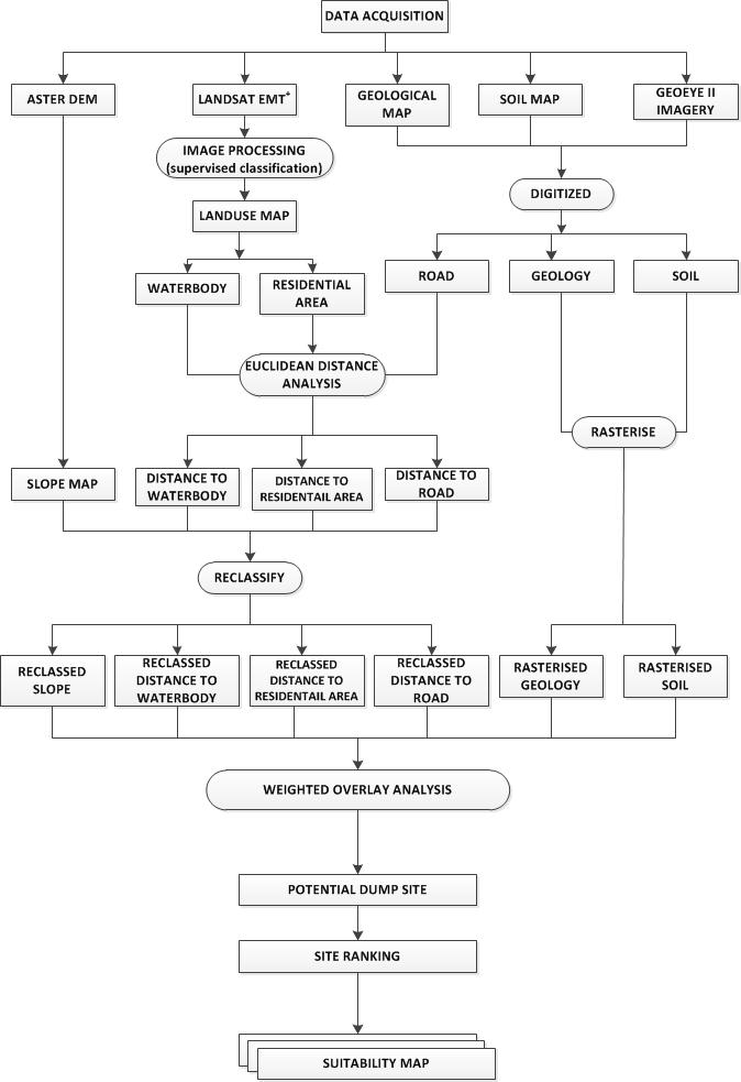 | Figure 2. GIS workflow adopted for the study |
|
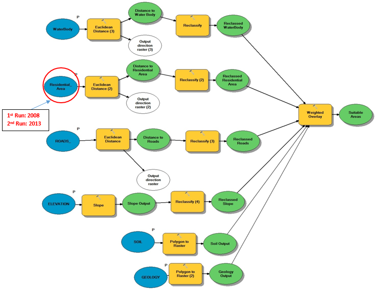 | Figure 3. Model builder adopted for the study |
4. Result and Discussion
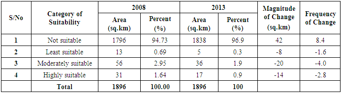
- This study focused on unravelling the implication of urban built-up land cover dynamics in the siting of suitable solid waste dumpsites in Ile-Ife. Figure 4 shows the criteria maps alongside their derivatives used for site suitability selection in the study. From the land use classification maps, built- up area showed a frequency of change in urban built-up land of 1.91sq.km which imply an increase within a period of 5 years from 82.472 sq.km in 2008 to 92.039 sq.km in 2013. The digitized waterbodies and major roads as well as elevation data were also extracted for the area under investigation.
 | Figure 4. Different criteria maps and their derivatives obtained for the study |
|
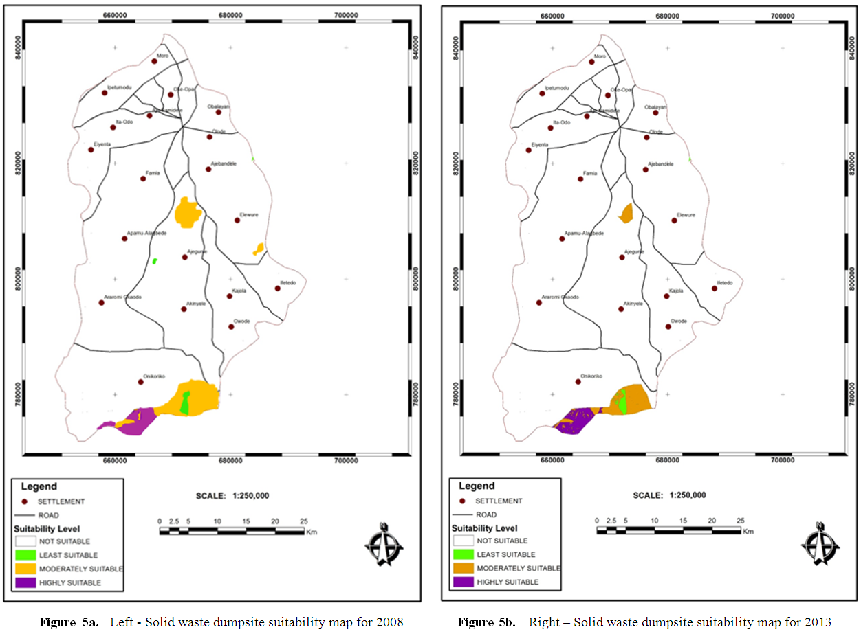 | Figure 5 |
|
5. Conclusions and Recommendations
- This study revealed different areas for siting dumpsites in the study area based on different suitability criteria (proximity to built-up areas, water bodies, and roads as well as underlying geology and soil) through the integration of RS and GIS techniques. More specifically, the use of spatial modelling tool with the adoption of MCE analysis - possibly implemented by changing different model components (in this case, urban built-up areas) within the GIS environment is laudable. It showed that areas mapped out to attain different solid waste dumpsite suitability categories do not tend to remain constant especially when the urban fabric or built-up space is considered in the development of final suitability map for any given time. In other words, the study revealed that within a period of five (5) years in Ile-Ife, built-up areal development significantly changed and more importantly led to a reduction in areas highly, moderately and least suitable for locating solid waste dumpsites. This study shows the veritable potential role of GIS for decision taken. It is therefore possible and needful for environmental managers and scientist to be able to develop simple, flexible and user-friendly models in developing waste management strategies. Such models can be updated more frequently by simply updating any (if not all) of the model’s components or adding new ones to obtain a new/different solid waste dumpsite suitability map such as the one developed in this study.While our result will be beneficial to raise awareness on the dynamism of urbanization and its impact on the available areas suitable for siting solid waste dumpsites in any urban area, there is still a need to update all the components required to run the model at any given time. Future research work should focus more on simulation and prediction of the availability and vagaries of the spatial extent of different suitable solid waste dumpsites, given the rapidity of urbanization in Nigerian cities, particularly for a more recent epoch. Lastly, to reap the gains of urbanization, development control must be effective, not only for the purpose of directing or steering development in an orderly manner but to as well restrict and or earmark areas that may be favourable for human habitation but may at the long run lead to the disappearance of high to moderately suitable sites for locating solid waste dumpsites in the long run. This study reaffirms the need for the use of waste recycling plants in cities that may, perhaps had their highly suitable sites subsumed due to sporadic urbanization. Hence, this will ensure smart, resilient and sustainable cities as urban dwellers will be least exposed and vulnerable to health hazards related to poorly sited solid waste dumpsites.