Abdullah R. Sonbul
King Abdulaziz University, Faculty of Earth Sciences, Engineering and Environmental Geology Department, Jeddah, Saudi Arabia
Correspondence to: Abdullah R. Sonbul, King Abdulaziz University, Faculty of Earth Sciences, Engineering and Environmental Geology Department, Jeddah, Saudi Arabia.
| Email: |  |
Copyright © 2016 Scientific & Academic Publishing. All Rights Reserved.
This work is licensed under the Creative Commons Attribution International License (CC BY).
http://creativecommons.org/licenses/by/4.0/

Abstract
The study area is located in the west central part of the Arabian shield along the Red Sea coastal plain. It comprises of old igneous and metamorphic rocks of the Arabian Shield overlain directly by the tertiary sedimentary succession and finally the tertiary basic volcanic flows (Harrat). The studied sand sheets and dunes cover the different rock units of the study area mainly within the flat areas and wadies. Due to arid rainless continental climatic conditions and geology about 37% of Saudi Arabia is covered by desert sands. These sands are mostly dynamic and causing environmental problems. The study area is considered as one of the most important, promising and strategic coastal areas between Jeddah and Rabigh. This coastal area is characterized by its plains and flattened ground so that the dynamic and migrated eolian sands (sand dunes and sand sheets) are on the most famous landforms in this area. The most common dunes are barchans, longitudinal rarely star-like dunes. These eolian sands are dynamic and migrate from one place to another so threatening communities and farms as well as highways and railways.
Keywords:
Sand Dune, Environmental Risks, Khulays, Saudi Arabia
Cite this paper: Abdullah R. Sonbul, Environmental Engineering Risks Assessment of Sand Dunes, North Jeddah, Saudi Arabia, American Journal of Environmental Engineering, Vol. 6 No. 6, 2016, pp. 164-173. doi: 10.5923/j.ajee.20160606.02.
1. Introduction
1.1. General Physiography
The study area is located between Jeddah and Rabigh which is considered as one of the most important, strategic, promising and attractive investment of the Saudi Red Sea coastal region. This coastal area has highly populated cities, highways and railways. These cities as well as the highways and railways are threatened by the risk of sand dune migration and, desertification of farmland that exists in abundance in this area [1]. At Wadi Khulays, sand dunes are mostly barchans and linear dunes. The inter dune areas are mostly deflated gravel surfaces, and some sand sheets are found around the piedmont [2-4]. This work represents the results of extensive field and laboratory testing carried out to assess Environmental Engineering risks of Khulays dune field, North Jeddah, Saudi Arabia.
1.2. Location and Geological Setting
The study area extends between latitudes 22°00¯N and 22°30¯N and longitudes 39°00¯E and 39°15¯E and locates an area between Jeddah and Rabigh. It is a part of the Arabian shield of west central Saudi Arabia (Figs. 1, 2). This part is generally comprises of four main rock units (Fig. 3). These are the Precambrian Arabian shield rocks, the Cenozoic sedimentary rocks, the Cenozoic sedimentary Basalt (Harrat) and the Quaternary sedimentary succession. These rock units are well seen in the satellite image of the study area. The interplay between the structural elements and the weathering processes led to the exposure of the different rock units of the study area. Each rock unit has its own color and degree of appearance on the satellite image.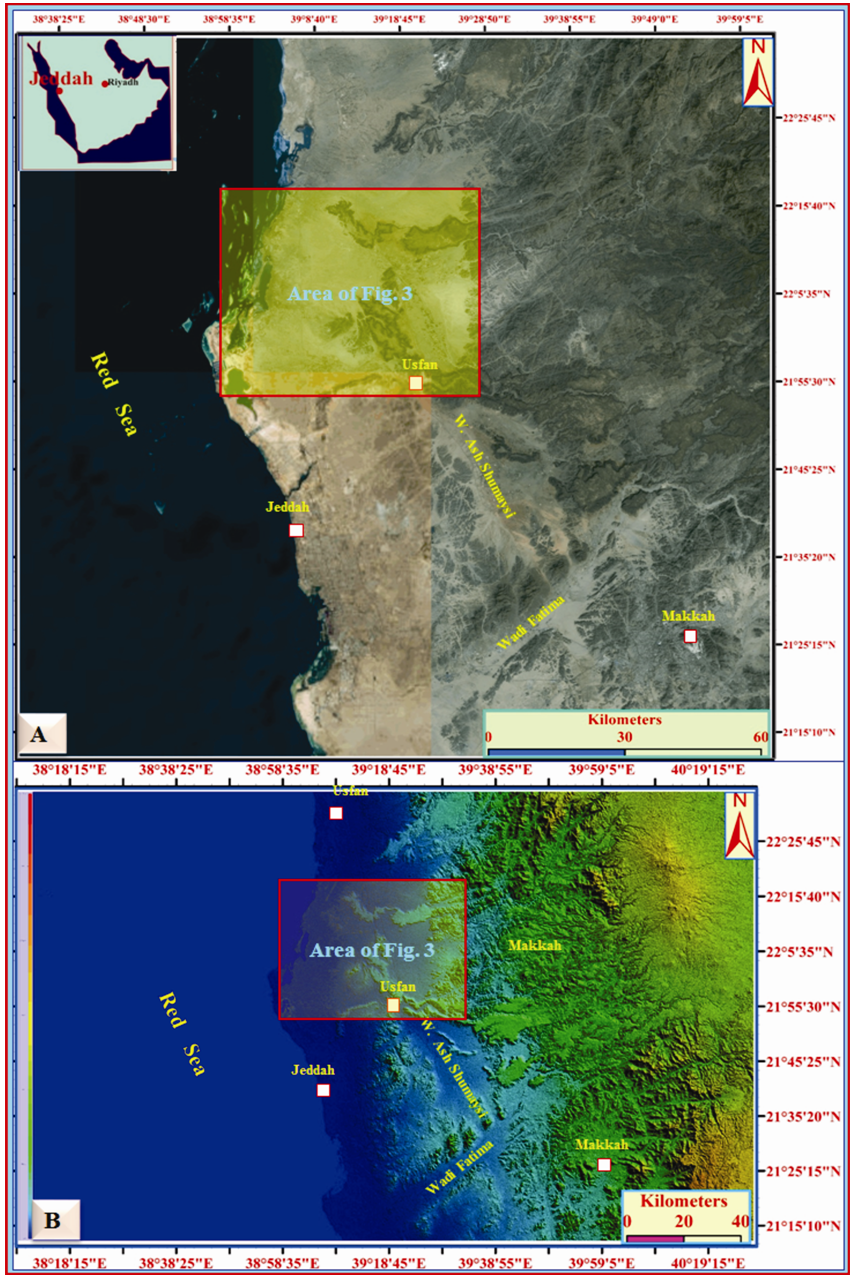 | Figure 1. A= Satellite image of Makkah District showing the main physiographic domains; B= Topographic elevations of Fig. A. notice the highest topographic areas are in the east while the lowest topographic areas are around the Red Sea coastal plain |
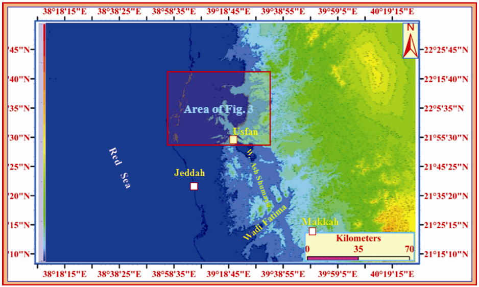 | Figure 2. Contour map of the areas of Figs. 1A, B showing the highest areas in the east and the lowest areas in the west |
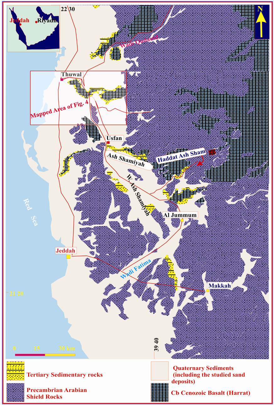 | Figure 3. Simplified Geologic Map of Makkah District [10] |
Geologically, the area around Asfan is represented by several rock units from older to younger as the following (Fig. 4): 1. Paleocene-Miocene which is classified into three rock units i.e. a) Asfan Formation consisting of limestone, fine-grained sandstones and mudstone beds; b) Shumaysi Formation which contains arkosic sandstone beds with minor conglomerates and limestone beds; and c) Hammah Formation composes mainly of alkali-olivine basalts.2. Quaternary deposits which include the following types: a) Alluvial deposits consists mainly of unconsolidated fining upward cycles of channel-lag gravels followed upward with sands, silts and thin layer of clays; b) Sabhka deposits were presented seaward and consisting mainly of silts and very fine sands; c) Aeolian sands are deposited by wind action to form sand dunes and sand-sheets, and d) Reefs and sands are concentrated and localized along the shoreline of the Red sea which is composed mainly of calcareous eroded coral reefs with other skeletal remains.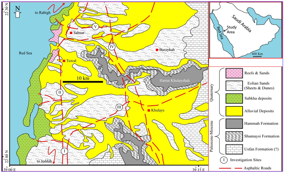 | Figure 4. Geological map of the studied area (modified from geological map of the Rabigh Quadrangle, sheet. 22D, Kingdom of Saudi Arabia, complied by [11] |
1.3. Materials and Methods
Detailed field investigations of the study area were performed to evaluate the environmental risks of sand dunes in Khulays dune field. The main geometric parameters (height, width, windward length and slip-face length) of more than 20 barchan dunes were measured in the field and listed in Table 1. For the study, 20 dune sand samples were collected from five sites. The dune sand samples were collected and placed in special cloth bags and numbered for further testing in the laboratories of Faculty of Earth Sciences, King Abdulaziz University. Geological maps and a Global Positioning System (GPS) instrument were used to locate the sample positions and detailed geological maps of the studied area were constructed (Fig. 4). The sieve analysis of the dune sand samples was done in accordance with [5]. The specific gravity and absorption tests were carried out in accordance with [6]. Also, the textural characteristics (forms and roundness degree) were counted for 100 quartz grains using the visual chart by [7] and listed in Table 2.
1.4. Sand Deposits of Jeddah Area
In Saudi Arabia, owing to dry continental climatic conditions, the topography and geological formations prevalent in these regions are the main causes of forming dune sands which cover vast areas. Approximately 37% of Saudi lands have been covered by desert sands (800.000 km2 of 2.3 million km2 [8]. These sands are mainly concentrated in eastern provinces and in the Arabian shield. Generally, the Saudi sand dunes of the Arabian shield are restricted to wadi courses that cut through the Precambrian igneous and metamorphic rocks of the Arabian Shield [9]. These sand dunes are dynamic elements, which grow and migrate causing environmental risks, limiting the expansion of cities, roads, power lines and communication lines. Serious geo-environmental hazards in the urban areas and road construction were recorded in the studied area owing to accumulations and migration of sand dunes (Figs. 5-8).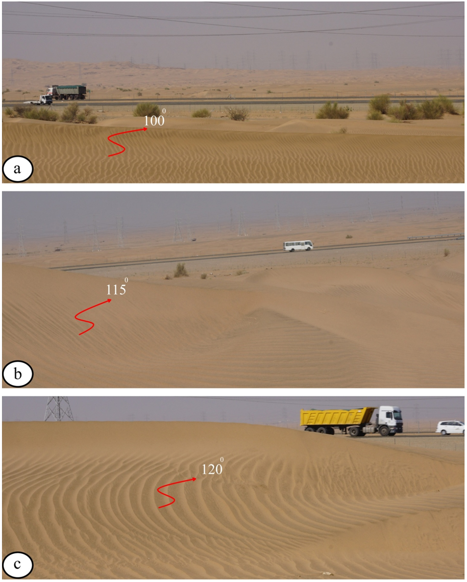 | Figure 5. Field photographs show sand dunes migrating towards asphaltic roads at sites I, III and V (a, b and c respectively) |
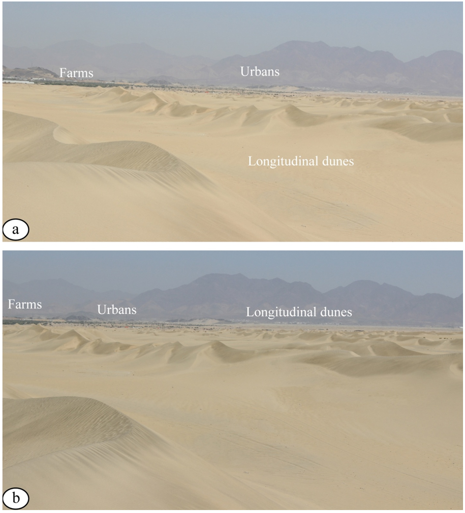 | Figure 6. Field photographs show longitudinal dunes migrating towards urban areas and farms at sites IV (a and b respectively) |
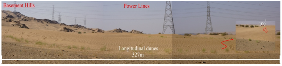 | Figure 7. Field panoramic photograph shows longitudinal sand dunes and sand sheets covering vast flat areas (Site I) |
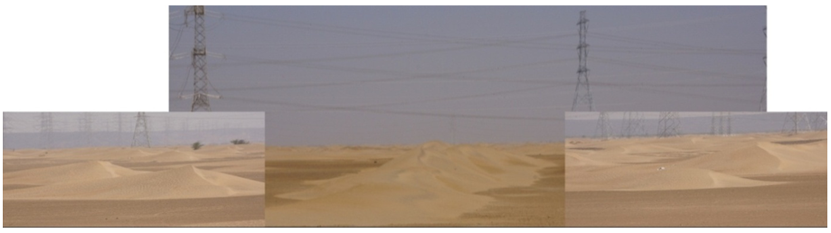 | Figure 8. Field panoramic photograph shows longitudinal sand dunes and sand sheets covering vast flat areas (Site III) |
2. Results and Discussion
2.1. Grain Analysis
The grain size analysis of dune sands was used to deduce their depositional environmental characteristics. The dune sands are usually characterized by well sorted rounded grains and cubic forms. Figure 9 shows the grain size distribution curves of the studied dune sands. These samples are predominantly medium sand (17.5% to 24.5%), fine sand (33.4% to 38.4%) and very fine sand (16.8% to 45.1%) with a very small percent of coarse sands (0.9% to 2.2%) and fines (silt and clay-sizes particles) around 2% (Table 1). The studied dune sands in different sites are characterized by unimodal distributions and were classified according to the Unified Soil Classification [12] as poorly graded sand (SP). The coefficient of uniformity (Cu) values of the studied dune sands varies from 1.9% to 2.4%, while the values of the coefficient of curvature (Cc) fluctuates between 1.11% to 1.23% (Table 1).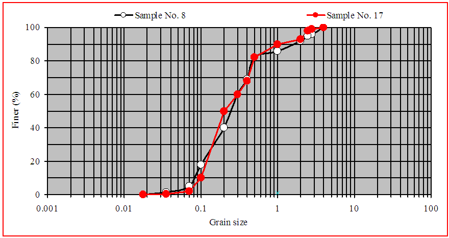 | Figure 9. Grain size distribution curves of the studied dune sands |
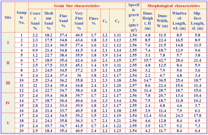 | Table 1. Basic physical properties and morphological characteristics of the dune sands of the study |
2.2. Geometric Parameters
The main morphological fractures (height, width, windward length and slip-face length) of more than 20 barchan dunes were measured in the field and listed in Table 1. The results of the geometric parameters measured, included dune height (H), dune width (W), windward length (wL) and slip-face length (sL) are illustrated in Fig. 7. The investigated dunes are individual asymmetrical barchan type having dune heights (H) varing from 2.2m to 13.4m, dune width (W) ranging from 6.7m to 42.7m and windward length (wL) fluctuating from 3.9m to 22.9m. Whereas, the slip-face length (sL) varies from 3.4m to 21.4m (Table 1). It was evident that, there is a strong positive correlation between these geometric parameters of the studied barchan dunes (Table 1 and Fig. 10).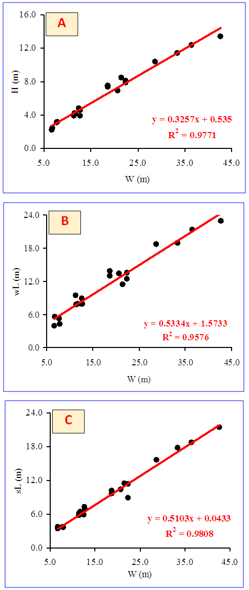 | Figure 10. Shows relationships of dune width (W) vs. dune height (H), windward length (wL) and slip-face length (sL) (a, b and c respectively) |
Figure 10 shows significant strong linear relationships (r-values ranging from 0.998 to 0.9979), between dune width (W) and dune height (H), windward length (wL) and slip-face length (sL) (R2-values are 0.97, 0.95 and 0.98 respectively). Consequently, the empirical relation between the various geometric parameters of the studied barchan dunes can be given as the following equations: | (1) |
 | (2) |
 | (3) |
2.3. Specific Gravity
The specific gravity of the studied dune sands ranges from 2.54g/cm3 to 2.57g/cm3 (Table 1). Indicating the specific gravity of the studied dune sands has a very narrow range due to mono-composition characteristics.
2.4. Textural Characteristics
The textural characteristics (shape and roundness) of clastic sediments usually reflect the environmental condition (e.g. intensity of abrasion, distance of transportation). The studied dune sands consist mainly of equant or spherical particles (84%), elongated grains (12%) with a minor amount of flay grains (4%, Table 2 and Fig. 11).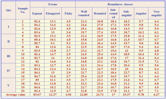 | Table 2. Relative frequency of different forms and roundness classes of the studied dune sands |
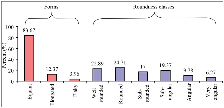 | Figure 11. Relative frequency of different forms and roundness classes of the studied dune sands (average values) |
Consequently, the studied dune sands mainly consist of rounded (24.71%), well rounded (22.89%), sub-angular (19.37%), sub-rounded (17%), angular (9.78%) and very angular grains (6.27%, Table 2 and Fig. 8). The highly relative abundance of equant rounded grains of the studied dune sands is a result of the long distance of air-transportation and subjection to pitting causing grains to become rounded faster than those transported in aqueous media [13].
3. Conclusions
Based on the field investigations and the experimental results, the most important conclusions can be summarized in the following points:Eolian sands in the study area are mostly composed of sand dunes and sand sheets which are dynamic and migrated. In the study area, sand dunes are consisting of barchan, longitudinal and star-shape dunes which originated from longitudinal ones owing to multi-direction winds.Texturally the studied dune sands are composed mainly of equant rounded to sub rounded grains. The geometric parameters (height, width, windward length and slip-face length) of the studied barchans have strong positive correlations. From the environmental risks point of view, the studied area sand dune migration causes major environmental problems for urban areas, asphaltic highways and farms (as shown in Figs. 5-8).
ACKNOWLEDGEMENTS
The author would like to express his appreciation for the contributions of Dr. El Sayed Sedek for his effort during the field work. Also the support from the lab facilities in the Faculty of Earth Science at King Abdullaziz University is highly value.
References
| [1] | Abu Seif, E.S., Sonbul, A.R., Hakami, B.A.H. and El-Sawy, E.K., 2016, Experimental study on the utilization of dune sands as a construction material in the area between Jeddah and Mecca, Western Saudi Arabia. Bull Eng Geol Environ, DOI 10.1007/s10064-016-0855-9. |
| [2] | Binda, P.L., 1983, on the skewness of some sands from Saudi Arabia. In: Ahlbrandt TS, Brookfield ME (ed) Eolian sediments and processes. Elsevier, Amsterdam, pp 27–39. |
| [3] | Zaidi, S.M.S., 1983, Landforms and geomorphic evaluation of Wadi Khulays Area, Western Saudi Arabia. Faculty of Earth Science King Abdulaziz University Jeddah Bull 5:153–166. |
| [4] | Sagga, A.M., 1998, Barchan dunes of Wadi Khulays, western region of Saudi Arabia: geomorphology and sedimentology relationships. J KAAU Earth Science 10:105–114. |
| [5] | ASTM C33, 2003, Standard specification for concrete aggregates. American Society for Testing and Materials, ASTM specification, Philadelphia. |
| [6] | ASTM C128, 1993, Standard test method for specific gravity and absorption of fine aggregate. ASTM C 128, American Society for Testing and Materials, ASTM specification, Philadelphia. |
| [7] | Powers, M.C., 1953, a new roundness scale for sedimentary particles, J Sediment Petrol 23, 117-119. |
| [8] | Garzanti, E., Vermeesch, P., Andò, S., Vezzoli, G., Valagussa, M., Allen, K., Kadi, K.A. and Al-Juboury, A.I.A., 2013, Provenance and recycling of Arabian Desert sand. Earth-Science Reviews 120, 1-19. |
| [9] | Al-Harthi, A.A., 2002, Geohazard assessment of sand dunes between Jeddah and Al-Lith, western Saudi Arabia. Environmental Geology 42, 360–369. |
| [10] | Johnson, P. R., 2006, Explanatory notes to the map of Proterozoic geology of western Saudi Arabia, technical report SGS-Tr-2006-4. |
| [11] | Ramsey, C. R., 1986, Geological Map of the Rabigh Quadrangle, sheet 22D, Kingdom of Saudi Arabia. Directorate General of Mineral Resources, Jeddah. |
| [12] | Terzaghi, K. and Peck, R.B., 1968, Soil mechanics in engineering practice. Wiley, New York. |
| [13] | El Sayed, M.I., 1999, Sedimentological characteristics and morphology of the aeolian sand dunes in the eastern part of the UAE: A case study from Ar Rub’ Al Khali. Jour. Sedimentary Geology 123, 219-238. |

 Abstract
 Reference
 Full-Text PDF
 Full-text HTML