-
Paper Information
- Previous Paper
- Paper Submission
-
Journal Information
- About This Journal
- Editorial Board
- Current Issue
- Archive
- Author Guidelines
- Contact Us
American Journal of Environmental Engineering
p-ISSN: 2166-4633 e-ISSN: 2166-465X
2016; 6(5): 148-155
doi:10.5923/j.ajee.20160605.03

Sustainable Viticulture: Geotechnologies for Update Permanent Preservation Areas in the Serra Gaúcha Wine Region, Brazil
 Abstract
 Reference
 Full-Text PDF
 Full-text HTML
R. Hoff1, H. Pauletto2, R. Alberti2, A. R. Farias3
1Empresa Brasileira de Pesquisa Agropecuária, Embrapa Uva e Vinho, Bento Gonçalves, Brasil
2Universidade do Vale do Rio dos Sinos – UNISINOS, São Leopoldo, Brasil
3Empresa Brasileira de Pesquisa Agropecuária - Embrapa Gestão Territorial, Campinas, Brasil
Correspondence to: R. Hoff, Empresa Brasileira de Pesquisa Agropecuária, Embrapa Uva e Vinho, Bento Gonçalves, Brasil.
| Email: |  |
Copyright © 2016 Scientific & Academic Publishing. All Rights Reserved.
This work is licensed under the Creative Commons Attribution International License (CC BY).
http://creativecommons.org/licenses/by/4.0/

The Serra Gaúcha wine region is important for production of grapes and wines in Brazil. For the geographical indications for wines (GI), environmental management is an important requirement to set a GI. Since 2002, “Vale dos Vinhedos” was recognized as GI, category Indication of Origin (IP) and from 2012, it was recognized as Designation of Origin (DO). From 2005, studies in this region were important for identification the permanent preservation areas and remote sensing and GIS techniques have being used for support. In this time, the map of vineyards was obtained by vectorization upon image as well as drainage network. The objective of this work was identify vineyards located in permanent preservation areas within the “Vale dos Vinhedos” GI after ten years gone, area that was reduced when region achieved the DO category. An aerial high-resolution data was used to generate digital elevation model that produced drainage and slope. The vineyards areas were obtained from measurement by high precision GPS. GIS techniques were employed for generate slope and distances maps (drainage areas). Subsequently was elaborated the preservation map, including areas with slope exceeding 45° and areas around 50 meters of drainage network and lakes. The crossing between PPA and vineyards maps produced the map of conflict areas, identifying vineyards deployed in conservation areas. The conflict use area was characterized mostly by vineyards deployed across drainage networks. The study showed that reducing the area of IP for DO allowed excluding areas with high slopes containing forests, reducing the areas of conflict in the GI. It can be concluded that the areas of the study showed a good preservation for the cultivation of the vine and the conflict areas can be converted in reclamation areas.
Keywords: Geographic appellation, Remote sensing, Environment
Cite this paper: R. Hoff, H. Pauletto, R. Alberti, A. R. Farias, Sustainable Viticulture: Geotechnologies for Update Permanent Preservation Areas in the Serra Gaúcha Wine Region, Brazil, American Journal of Environmental Engineering, Vol. 6 No. 5, 2016, pp. 148-155. doi: 10.5923/j.ajee.20160605.03.
Article Outline
1. Introduction
- Agriculture and their associated activities can affect the territorial aspects, changing the natural environment in geographical space, due the fact that people staying in areas for particular purpose. In agriculture, natural areas have intended for the production of food for the survival of humanity, even though this occurs in complex and compartmentalized way. The agricultural activities have close and permanent relationship from the beginning of history. From the moment that humans stood at specific places and their nomadic journeys were reduced, determine what the best place to produce has become extremely important gains in agricultural production, even though it was initially intended for the livelihood of people.With technical development, mapping activities have modernized, as well as the techniques for agriculture. Soil surveys focused on the production of certain agricultural product, regional climatic characterization, mapping of pests and varieties, are some of the topics now commonly performed to support agricultural development. Considering that today the number of known variables that influence the quality and agricultural productivity is significant and extensive, there is a need to integrate this vast data structure. By an interactive and relational environment, such as Geographic Information Systems (GIS), it is possible to analyze different representations of reality for supporting the decision making process.The GIS makes possible to integrate spatial and non-spatial information from diverse sources in a single database and enabling the generation of new data derived [1, 2]. These systems may be tools with different applications in agriculture. Although this tool is not restricted to the field of agricultural production, its use has shown significant results with regard to the organization and optimization in viticulture. In addition to spatial planning and temporal characterization of production, the tools and the data entered in a GIS allow to producers to organize the agricultural region for other purposes, such as the delimitation of areas of permanent preservation, legal reserve, resource management water, among others.The environmental laws in Brazil are focused in agriculture to preserve areas and maintain sustainability. However, environmental problems are reached significant dimensions, affecting the stability of ecosystems. The investigation for new means of production considering the environment needs searching sufficient data for decision-making. Reflections on the socioeconomic context, for the awareness of these problems, makes it necessary that the researches developing studies looking for solutions to the environmental impacts caused by human activities [3].In study conducted made in the Rio Alegre watershed, Espírito Santo (Brazil), 78 percent of the area is conflicting use in coffee culture, having few areas of the ecosystem and only little fragments of native forest [4]. In that region, were identified use conflicts in 13 percent of the area under study [5]. This problem is a result of the extensive areas with agricultural potential for crops and pastures in areas of permanent preservation. The concern of society with planning comes from ancient ages, but in modern times was to the environment, incorporating social, political, ecological and economic aspects [6]. Environmental planning takes knowledge about the ecosystem in order to make a better fit between man and nature, including a large thematic diversity around three axes: a) prevention and/or correction of environmental problems of economic sectors; b) management of environmental resources and natural resource planning; c) prevention and/or environmental conservation [7]. In Brazil, the permanent preservation areas (PPA) have been the focus of studies for environmental management in agriculture, as provided by the Brazilian Forest Code. The PPA areas are covered or not by native vegetation with environmental function of preserving water resources, landscape, geological stability, biodiversity, migration of fauna and flora, soil protection and ensuring the life quality to human populations, according Law No. 4771/1965 [8]. Thus, PPA are considered the forests and other forms of natural vegetation along of drainages defined according the width of the watercourse, strong slope areas, areas around lakes and water reservoirs, springs, and other areas that may be declared for preservation by the government. Therefore, environmental planning is an ongoing process and meets the requirements to current and future environmental demands. It involves the collection, organization and analysis of information through systematic procedures and methods to achieve the best alternative decisions or choices. The use of available resources according to their potential is intended to achieve specific goals in the future, leading the improvement of a given situation and the life quality of societies [9].The Serra Gaúcha Wine Region is the Brazilian largest producer of grapes and wines [10], have looking for recognition through geographical indication (GI) with a view to adding value to local products. Since the 1990s, the winegrowers' associations looking for characterize the territory of production of fine wines in Rio Grande do Sul through the GI establishment, understanding that the environmental variable values producing region [11]. Currently, this producing region has developing GI studies by a partnership between Embrapa Grape and Wine, Universities and producers associations.According [12] the evolution of viticulture in the Rio Grande do Sul State, especially in the Serra Gaúcha region, the identity is linked to Italian immigrant. The descendants of these immigrants, installed since the nineteenth century in the municipalities of the Serra Gaúcha Wine Region, acquired a colony of land per family (approximately 25 hectares), which generated an intense exploration of these areas. Over the years, agricultural practices disregarded the environmental preservation areas on the property to establish a vineyard, with common drainage construction to eliminate the streams and springs. The main studies in Brazil for geographical appellation of wine production were “Vale dos Vinhedos” GI [12], “Monte Belo” GI [13], and “Pinto Bandeira” GI [14]. These GI were considered, among other themes, environmental aspects, including permanent preservation areas (PPA), which were identified more accurately and quickly by remote sensing and GIS techniques, based on criteria of the Brazilian Forest Code Law No. 4771 of September 15, 1965 [8]. For example, there are some studies areas by GIS and remote sensing techniques in these regions [15-17].Since 2002, “Vale dos Vinhedos” was recognized as GI, category Indication of Provenance (IP) and since 2012, it was recognized as Designation of Origin (DO). From 2005, studies in this region were important for identification the permanent preservation areas and remote sensing and GIS techniques have used for support. In this time, the map of vineyards was obtained by vectorization upon image as well as drainage network. The Serra Gaúcha wine region integrates important ecosystems linked to the Atlantic Forest Biome [18]. In the Vale dos Vinhedos DO there are many preserved forest fragments and the results of this study may support the maintenance to keep the forest in harmony with viticulture [19]. The objective of this study was identify vineyards located in permanent preservation areas within the “Vale dos Vinhedos” GI after ten years gone, wherein area that was reduced when region achieved the "DO" category. Thus, the purpose was storing and organization geographic data in GIS for interpretation of socio-environmental reality of the region. The purpose in this case is to diagnose areas that, according to the current Brazilian Forest Code how PPA, but that currently support agricultural use, not be in compliance, therefore, with the legal requirement to reclamation.
2. Geotechnology
- Many modern socio-economic problems such as high population density, pollution, desertification, natural disas-ters, among others, are linked to the geographical area. The location of a new agribusiness, determining the best soil for a culture, or the best route for transporting products can also be processed in a geographic in-formation system (GIS). A GIS environment can be defined briefly as a computer application to associate spatial nature of information and alphanumeric information.Differing other information systems, GIS has the ability to manipulate information based on spatial attributes and linking layers of data through common attributes georeferenced, allowing combine, analyze and produce thematic maps. The GIS allow integrating different kinds of infor-mation and thus viewing multiple scenaries in order to solve complex problems. The features of this system have in-creasingly attracted multiple users, due to its diffusion and success in agriculture.In the agriculture, the GIS has been widely used in planning and management, such as irrigation, agricultural potential maps, and installment projects, among others. In addition, GIS have been used to support precision agriculture and environmental studies, as most of the technologies require georeferenced information, as seen in studies of viticulture [20, 21]. Initially, the uses of GIS tools for precision agriculture have been linked to the idea of large agricultural enterprises, since the cost of tools and supplies necessary became restricted their use on great farms. With the advancement of knowledge of the techniques of collecting and organizing data, reducing the cost of the set of tools (computers, spreadsheets, satellite images) and the creation of free software for remote sensing and GIS, also spent to be available for the small property and other users, such as SPRING [22]. The GIS provides the organization of data and its year-over-year, resulting in a historic data, as being accumulated and analyzed over time, serving as a basis for decision-making to the productor, increasing profitability and management accuracy in agriculture. So the environmental planning becomes very important, especially in areas of annual crops, perennial crops or commercial forests, which have long life, where it should not be considered just the traditional agricultural year and the data should therefore have an ongoing process of analysis.The parameters and data collection varies according to each purpose and mapping structure available for data acquisition. Thus, any element that has a spatial dimension can be represented, mapped and analyzed based on tools available in GIS environment. In agriculture, this involves productivity-mapping, physical and chemical conditions of soil and plants, disease and pest control, application optimization of chemical inputs and other attributes. Among the numerous opportunities offered by the use of this tool, the only fundamentally necessary imposing is the collection of the data as a reference coordinate system, commonly done with GPS (Global Positioning System) receiving equipment. In the absence or inability to use this instrument, the spatial representation of the elements can be made from topographic maps or using Internet tools, such as Google Earth.
3. Material and Method
- The study area of Designation of Origin “Vale dos Vinhedos” is located in Bento Gonçalves municipality, Rio Grande do Sul State, shown in Figure 1.
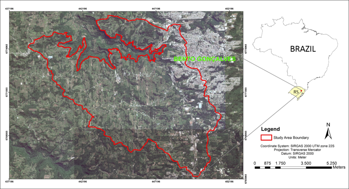 | Figure 1. Location of Designation of Origin “Vale dos Vinhedos”, Serra Gaúcha wine region, Brazil |
4. Results
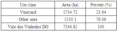
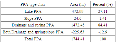
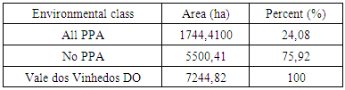
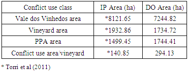
- Today the area of Vale dos Vinhedos GI was reduced compared since the indication of provenance (IP), with 8121.65 hectares, until the Designation of Origin (DO) with 7244.82 hectares. Others aspects have changed, such as: i) altitude in 2005 ranges from 204 to 723 meters, altitude in 2015 ranges from 376 to 723 meters [25]; ii) slope above 45 degree in 2005 has 60.25 ha, while in 2015, only 24.6 ha.Consequently, permanent preservation areas on steep slopes and river edges are outside in the new area.
|
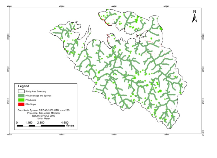
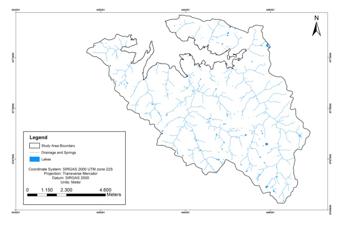 | Figure 2. Drainage, springs and lakes in Vale dos Vinhedos DO, Brazil |
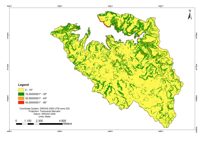 | Figure 3. Intervals of slope in Vale dos Vinhedos DO, Brazil |
|
 | Figure 4. Permanent preservation areas in Vale dos Vinhedos DO, Brazil |
|
|
|
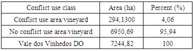
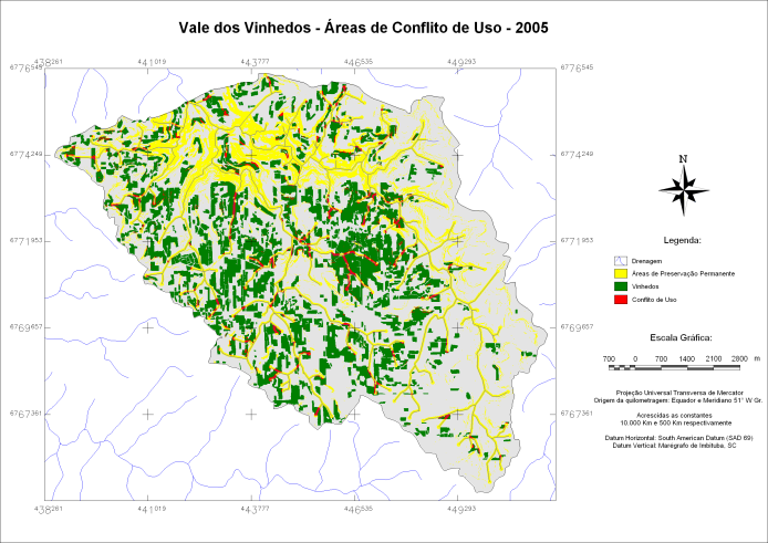 | Figure 5. Conflicting use areas in the Vale dos Vinhedos DO at 2005 survey (Torri et al 2011) |
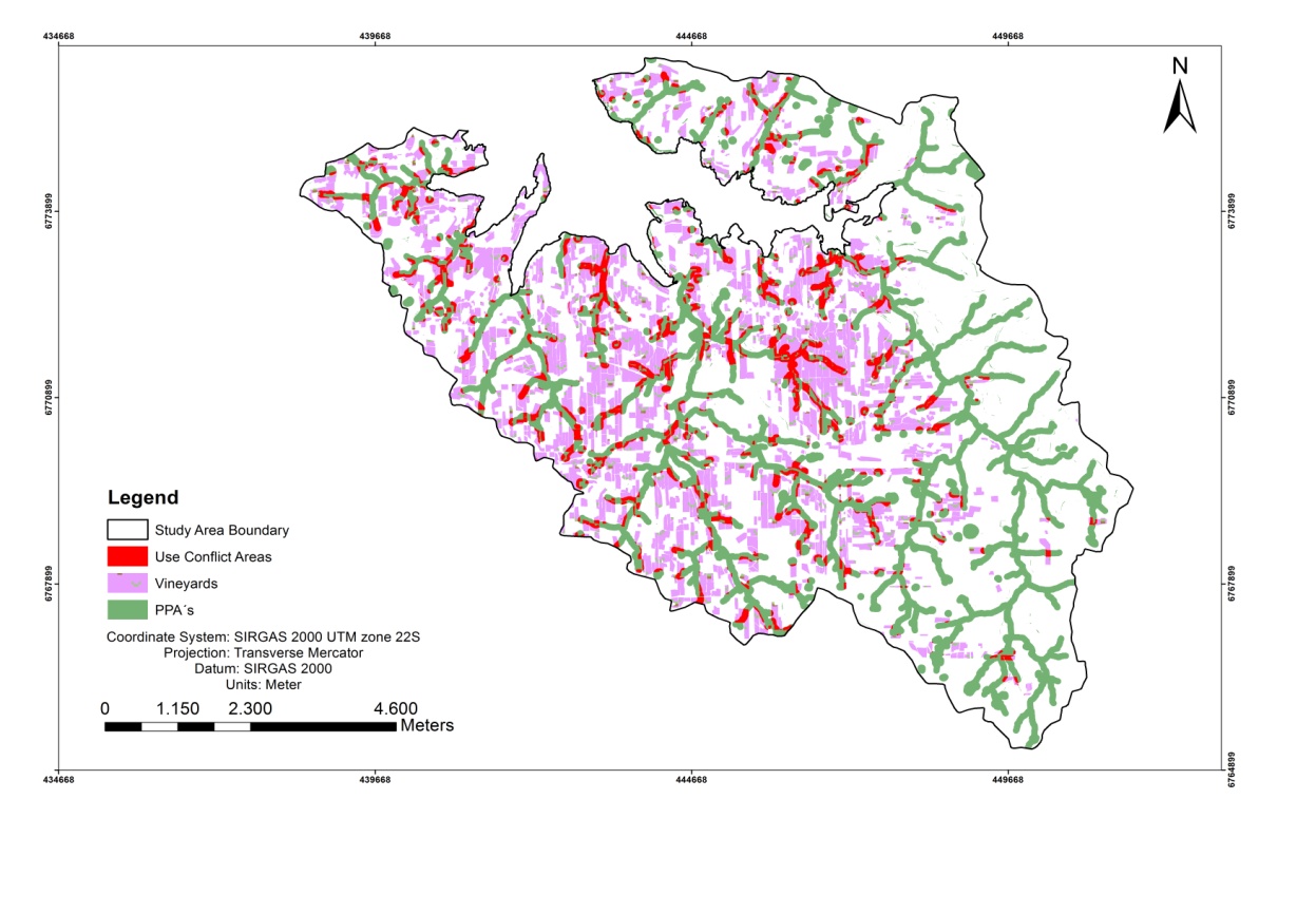 | Figure 6. Updated conflicting use areas in the Vale dos Vinhedos DO at 2015 survey |
5. Conclusions
- In the present study, environmental criteria were modified PPA limit due to current laws such as: i) around the drainage areas were increased from 30 to 50 meters; ii) slope limit was reduced from 47 percent to 45 degrees. The database was improved compared to previous studies, such as: iii) the area was decreased in relation to the indication of provenance (Table 5); iv) the drainage network and lakes were better detailed (Figure 2) and v) the updated vineyards showed smaller area than in the past decade (Figure 6). Overall, this represented a protection of water sources, including springs.The obtained data - PPAs and conflict use areas showing a high degree of detail, which generated accurate information. This was very useful in the Serra Gaúcha region with wavy relief that favors the increase of the area in conflict when under pressure from agricultural use, as in the case of vineyards. The mapping of PPA, however, is to favor areas to be recovered and preserve other, adding value to regional product, i.e., fine wine. In addition, these studies have contributed to the evolution for the Vale dos Vinhedos DO, approved by National Institute of Industrial Property - INPI at 2012. Based on this study, it is possible to better plan the deployment of vineyards as regards environmental laws, since the mapping has high resolution, making it suitable for precision farming studies. Such products enabled an interpretation of the current development status of viticulture and its potential as well as their conflicts of uses, supporting future action planning, whether in public or private level in the areas of geographical indications.
ACKNOWLEDGEMENTS
- The authors thank to Financiadora de Estudos e Projetos – Finep, Conselho Nacional de Desenvolvimento Científico e Tecnológico – CNPq e Fundação de Amparo à Pesquisa do Estado do Rio Grande do Sul - FAPERGS.