-
Paper Information
- Paper Submission
-
Journal Information
- About This Journal
- Editorial Board
- Current Issue
- Archive
- Author Guidelines
- Contact Us
American Journal of Environmental Engineering
p-ISSN: 2166-4633 e-ISSN: 2166-465X
2014; 4(5): 85-93
doi:10.5923/j.ajee.20140405.01
Highway By-pass Alternatives for a City: A Digital Case Study from Air Pollution Dispersion Criterion
 Abstract
 Reference
 Full-Text PDF
 Full-text HTML
S. B. Pawar , M. Husain
Civil Engineering Department, SSBT’s College of Engineering and Technology, Bamnhori, Jalgaon, MS, India
Correspondence to: M. Husain , Civil Engineering Department, SSBT’s College of Engineering and Technology, Bamnhori, Jalgaon, MS, India.
| Email: |  |
Copyright © 2014 Scientific & Academic Publishing. All Rights Reserved.
Meteorology plays key role in the dispersion of air pollution. However the highway geometry is also an equally important aspect. In fact the combination of the two variables can significantly affect the air pollution accumulation on either side of the highway. Hence the geometry of the highways passing through cities should be judiciously selected keeping in view the meteorological aspect too. This will reduce the air pollution concentration along highways and consequently will protect the human health. The present work is a case study of city of Jalgaon. The AH no. 46 passes through the city. It has high traffic density. Hence the proposal for a bypass is under consideration of government authorities. The authors have developed a computer simulation model to analyze the air pollution dispersion taking into account the meteorological parameters and highway geometry. The analysis has revealed that due to the existing typical layout of highway and prevailing meteorology there is a drastic effect on the air pollution concentration over the city. The proposed bypass highway also has the same problem. Hence an alternative geometry for the highway has been proposed. The alternative geometry is able to significantly reduce the air pollution concentration.
Keywords: Air pollution, Dispersion, Meteorological factors, Highway planning
Cite this paper: S. B. Pawar , M. Husain , Highway By-pass Alternatives for a City: A Digital Case Study from Air Pollution Dispersion Criterion, American Journal of Environmental Engineering, Vol. 4 No. 5, 2014, pp. 85-93. doi: 10.5923/j.ajee.20140405.01.
1. Introduction
- In India the awareness about air pollution is still at nascent stage. The first air pollution act came in existence in 1981 [1]. Later India’s pollution control authorities had been prompt enough to recognize EURO norms and even to promulgate Bharat stage emission norms for vehicular air pollution control. Vehicles are the prime cause of air pollution in India [2]. With rapid industrialization and population growth, this problem is taking gigantic shape in India. The air pollution coming out of a source is dispersed in certain volume of air and is diluted [3]. However, this dispersion and dilution is strongly influenced by the meteorological factors including wind velocity, solar radiation, humidity, atmospheric thermal gradient, etc. The researchers had begun to explore these variables as early as in 1947 [4-5]. Sutton has analyzed the micrometeorological parameters that influence the air pollution dispersion. The dispersion of air pollution is a complex phenomenon. The first models to describe the air pollution dispersion came into existence in 1960-70s [6-7]. The earlier models considered point sources which mathematically resemble to stacks. However, Turner (1969) considered a line source in his mathematical simulation [8]. The line sources resemble to a highway. Thus it became possible to analyze the dispersion of air pollution through a highway. The authors have done an attempt to apply Turner model through computer simulation to study the air pollution dispersion over a city due to the highway passing through it. Presently the highway authorities are working for a bypass highway for the city to reduce the air pollution. The authors have extended their simulation study further to analyze the effect of bypass highway layout and have also proposed an alternative highway layout keeping in view the local meteorological conditions. The analysis shows that the alternative thus proposed shall greatly reduce the air pollution over the city.
2. The Software
- Turner’s model for dispersion of air pollution from line source is written as follows [8]:
 | (1) |
 à angle between wind direction and line source.The equation (1) is solved numerically. A computer simulation software is developed using FORTRAN 77. The software is facilitated to use inputs like vehicular emission levels, wind velocity and other meteorological parameters. Hence the software can be used to analyze the effect of varying meteorological parameters on the air pollution dispersion. The equation (1) is applicable when
  <450. In case the
  > 450, the wind velocity is divided into two components. The parallel component is ignored and the perpendicular component is considered. As the source length is sufficiently large, the uniform distribution in y direction is assumed, above-mentioned assumption of ignoring the parallel component is justified. The software is given in appendix 1. Referring to the wind rose diagram of figure 3, it can be seen that the wind is quiet during January to March. From April to September it blows heavy in the direction W-E. in October to December there are mild winds from E-W directions. Hence the most significant wind direction can be considered as W-E, with the maximum velocity 2.36 m/sec. For the highway segments, as defined in Fig 1, it is parallel to segment 1-2 and 4-5. For segments 2-3 and 3-4, the wind direction is approximately 45°. For segments 1-2 and 4-5, the wind velocity is considered to be at a nominal angle of 3° angle to the highway. It is resolved in two components 2.36cos3 and 2.36sin3. The later component is perpendicular to the highway and it is used as input to the software. The parallel component is ignored with the justification as given earlier.
 3. Results and Discussion
- The present work has used Turner’s model and solved is numerically. A computer software is developed using this model. The software can be used to estimate air pollution dispersion due to any highway. In the present work, a case study is done for the city of Jalgaon (21.05N, 75.57E, at 250 m from mean sea level). AH46, also known as NH6, passes through the city. Fig 1 shows the city with highway layout. The highway is heavily loaded with the traffic. It creates lot of air pollution in the city. Considering the pollution aspect as well as the traffic congestion aspect, the government has decided to provide a bypass to the city. Fig 2 shows the bypass highway layout. The present work has used the software for air pollution dispersion studies. The software has been used to explore following aspects, using the vehicular emission data, vehicular density and meteorological parameters from the literature:(i) Existing level of air pollution in the city: it is found to be significantly high. (ii) Changes in the air pollution due to the proposed highway bypass, considering the prevailing meteorological conditions of the locality. (iii) An alternative bypass layout that can significantly reduce the air pollution level. The alternative bypass is shown in Fig 3.
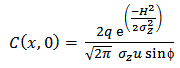
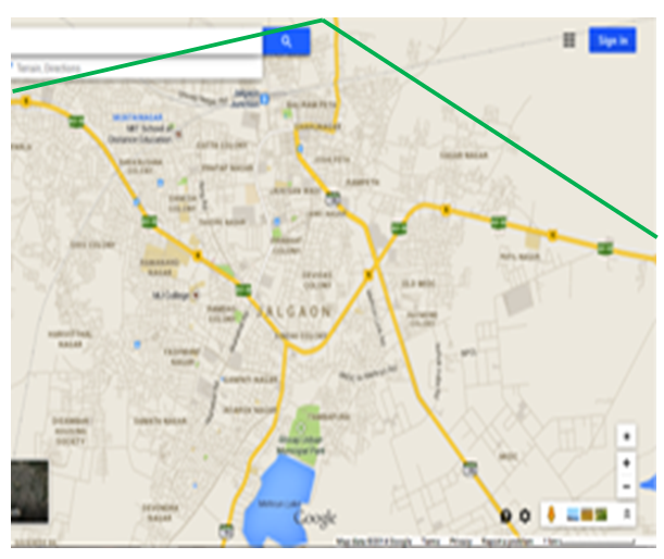
 | Figure 1. Road map of Jalgaon city. The NH6 (AH46) is shown in pink color. The stars are used to denote the segments of highway. Lengths of segments are as follows: 1-2: 4.5 km, 2-3: 4.8 km, 3-4: 3.7 km, 4-5: 5.3 km |
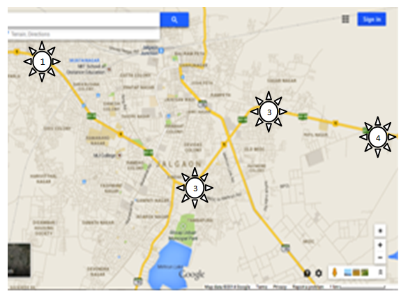
 | Figure 2. Bypass highway layout of Jalgaon. Bypass is shown in green color |
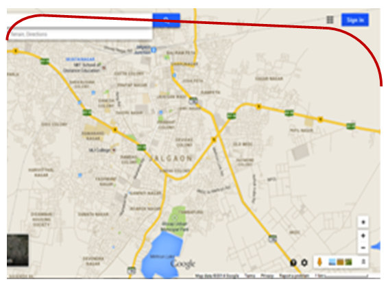
 | Figure 3. Proposed alternative bypass highway for Jalgaon. The proposed alternative is indicated in black |
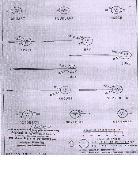 | Figure 4. Wind rose diagram for Jalgaon city |
|
|
4. Conclusions
- Dispersion of air pollution from a line source is a complex phenomenon. Its dependence upon meteorological parameters has been recognized by engineers. However its dependence upon combination of the line source layout and meteorology is a new concept. The concept has been first time proposed by the authors and has been justified by the digital simulation in the present work. The information is of great significance for town planners. Traditionally the town planners have worked on the plain fundamental concept that the highways should be away from the cities so as to minimize the air pollution. However the present work has linked the highway geometry with the local meteorology. It is in fact an emergence of new dimension in the domain of town planning as well as highway planning.
Appendix 1