-
Paper Information
- Previous Paper
- Paper Submission
-
Journal Information
- About This Journal
- Editorial Board
- Current Issue
- Archive
- Author Guidelines
- Contact Us
American Journal of Environmental Engineering
p-ISSN: 2166-4633 e-ISSN: 2166-465X
2013; 3(1): 77-83
doi:10.5923/j.ajee.20130301.11
Groundwater Quality Appraisal in Southern Parts of Kaduna State, Nigeria
 Abstract
 Reference
 Full-Text PDF
 Full-text HTML
Eduvie Martin Obada 1, Olaniyan Isaac Oladejo 2
1National Water Resources Institute, Kaduna, Nigeria
2Department of Physical Sciences, Ondo State University of Science and Technology, Okitipupa, Nigeria
Correspondence to: Olaniyan Isaac Oladejo , Department of Physical Sciences, Ondo State University of Science and Technology, Okitipupa, Nigeria.
| Email: |  |
Copyright © 2012 Scientific & Academic Publishing. All Rights Reserved.
Assessment of groundwater quality from the rocks of the Basement Complex in the southern parts of Kaduna State, Nigeria was carried out. Forty samples from boreholes, hand-dug wells and springs were collected during the dry and raining seasons for chemical and bacteriological analyses. The essence of the study is to assess the quality and the portability of the groundwater using the World Health Organization (WHO) standards for drinking water. The results of the water samples analyses indicate a low total mineralization. However, results of some hand dug wells suggest that the water might have been contaminated due to human activities and closeness to pit latrines/soak-away and other domestic refuse dumps. The Piper’s trilinear and Schoeller diagrams showed that the groundwater in the study area can be classified to be Ca-Na-HCO3 fresh water.
Keywords: Groundwater Quality, Total Mineralization, Pollution Indicators, Water Chemistry
Cite this paper: Eduvie Martin Obada , Olaniyan Isaac Oladejo , Groundwater Quality Appraisal in Southern Parts of Kaduna State, Nigeria, American Journal of Environmental Engineering, Vol. 3 No. 1, 2013, pp. 77-83. doi: 10.5923/j.ajee.20130301.11.
Article Outline
1. Introduction
- In spite of the considerable investment of Government in Nigeria over the years in the provision of water for domestic, industrial and agricultural purposes, a large part of the population still does not have access to water of adequate quantity and quality. It is estimated that only 58% of the inhabitants of the urban and semi-urban areas of Nigeria and 39% of rural areas have access to potable water supply. In spite of these low figures, the average delivery to the urban population is only 32 litres per capita per day (lpcd) while the value for rural areas is 10 lpcd[1] . Kaduna State is located in the humid, wet-dry tropics, in the northern reaches of the Guinea Savannah. Geologically, the area under investigation lies within the Crystalline Complex. In the study area, the average rainfall is 1350 mm per annum, and is distributed within four to eight months, usually from March to October[2],[3]. The ever increasing demand for water, especially for domestic purpose, has led to widespread and very intensive search in all parts of Nigeria, especially in the Crystalline Complex where occurrences of groundwater are considered low and generally to be under the control of geological structures and weathered overburden. Most rural communities in southern parts of Kaduna State depend largely on groundwater through wells and boreholes for their water needs, since most surface sources are more susceptible to pollution and are expensive to develop. In view of the importance of this source of water to the communities in the area, there is therefore the need to assess the water chemistry and bacteriological characteristics of the groundwater in the area. The present research is also aimed at detecting localities with good water quality and also comparing present results with available water quality data carried out within the project area over a period of time.
2. The Study Area
- The study area, southern parts of Kaduna State in the Northern Nigeria, covers about 24,500 square kilometers and lies between latitudes 9° 00’-10° 45’N and longitudes 7° l0’- 8° 45’ E. The area has boundaries with Niger State to the west, Federal Capital Territory (FCT) and Plateau State to the South and South-east, respectively, while Kano and Bauchi States have borders to the east of the study area (Figure 1).
3. Geology and Hydrogeology
- The southern parts of Kaduna in the north-central Nigeria forms a part of the West African Mobile zone which extends from east to west from Nigeria, and Ghana where it is “sutured” to the West African craton by the Pan African Dahomeyan (or Beninian) belt. The whole ensemble of rocks in this zone had undergone an extensive episode of “remobilisation and reactivation” during the Pan-African thermotectonic event some 600 my ago[4]. The entire land area is underlain by Precambrian migmatite-gneiss complex, metasediments/metavolcanics (mostly schists, quartzite, and banded iron formations). Pan African granitoids and calc-alkaline granites, and volcanics of Jurassic age. These various rock units, especially the gneisses and the schists, have been affected by many periods of orogenic movements, resulting in extensive deformation and migmatization. McCurry[5] reported that the oldest rocks of the area are the gneisses and older metasediments believed to be Birrimian in age (about 2500 my).The groundwater prospects of Basement areas have mixed reviews in the literature. The igneous and metamorphic rocks constituting the Basement Complex of Nigeria as a whole has an undeserved reputation as poor aquifers[6],[7].Groundwater occurrence in the area could be grouped into three. These are:(a) The Weathered/Fractured Basement Complex(b) The Newer Basalts(c) The River AlluviumThe weathered granular sandy zone is composed of coarse-grained sands, which form a level below the loose clayey laterite. The granular sands may consist of sands or gravels derived from the disintegrations of the crystalline rock. There are good prospects for groundwater production in the horizon of the intermediate zones with an average thickness of about 6 m[8]. The majority of hand-dug wells in the study area terminate in this part of the zone.The Newer Basalts occur in the vicinity of Kafanchan and Manchok along the western edge of the Jos Plateau. The Basalts were erupted after the Plateau had achieved almost its present-day topography and are themselves little affected by erosion[5]. Thus, they often overlie alluvial deposits. Zones of weathering and beds of alluvium also occur between individual basalt flows. The aquifer potential of the fluvio-volcanic sequence is good and yields of 370 to 500 m3/d have been obtained. Also, a borehole (No. GWR/21/l) drilled at Tum village, within the Newer Basalts, produced a yield of l2.6 m3/h. A highly productive spring (Kajim) emerges from the Newer Basalt at Manchok. The dry season flow of this spring is about 11,000 m3/day[9]. It forms the headwater of a tributary of the Kaduna River.
4. Methodology
- Water samples collected from boreholes, hand dug wells and springs were subjected to water quality assessment during the study. The chemical elements, which are found in groundwater, come from rains, organic action in the soil and decomposition of minerals in the rocks through which the groundwater travels. The present research is aimed at detecting localities with good water quality and also comparing present results with available water quality data carried out within the project area over a period of time.The chemical parameters that are the most essential in groundwater chemistry and present in important quantities which were analysed for include: major ions concentration (sodium, calcium, magnesium, potassium, bicarbonate, sulphate and chloride). To further achieve a better assessment of the water quality, nitrate and iron were also analysed for.
5. Sampling and Chemical Analysis
- In the present study, two sets of sampling with a total of forty samples (boreholes, hand-dug wells and springs) were collected for chemical analysis. However, after subjecting the results to quality control by means of the ionic balance, nine (9) of the results were rejected due to error limit of over 10%. The details of sample locations are shown in Figure 1. The temperature, pH, specific conductance and bicarbonate were determined on the spot using Hach Kit and Kent pH meter to obtain accurate results because these properties change with time on exposure of the water sample to the atmosphere[10]. The major cations Ca++, Na+. K+ and Mg++ were acidified on the spot and taken to the laboratory for analysis using Atomic Absorption Spectrometer (AAS) and flame photometer, while the anions Cl-, S042-, NO3- were determined by titrimetrical method and calorimetric techniques. Bacteriological analyses of hand-dug wells in parts of the study area were carried out in Mando and Kawo areas of Kaduna metropolis both during rainy and dry seasons. Faecal coliforms and faecal streptococcus were the indicator organisms analysed for during the research. Membrane filter technique was used and Eosin Methylene Blue (EMB) agar was the culture medium, while a temperature of 37° C was maintained and incubated for a period of 18-24 hours.
6. Results and Discussions
- Tables 1 and 2 show the results of the physico-chemical analyses and the ionic balance of groundwater in the study area. The water samples have a low total mineralization as indicated from the conductivity values. The Piper’s trilinear diagram (Figure 2) and Schoeller diagram showed that the groundwater in the study area can be said to be a Ca-Na-HCO3- fresh water. Generally, since the Basement rocks contain minerals such as feldspars, amphiboles, pyroxene, and micas, which contain various amounts of the elements, they are often released into groundwater when the minerals undergo weathering. Similar results have been obtained from Kaduna area[11] and central parts of northern Nigeria with similar geology[12].The Sodium Adsorption Ratio (SAR), which indicates the extent to which soil adsorb sodium from water is influenced by the concentration and composition of the soluble salts. This parameter is important because, above certain levels, the adsorbed sodium has adverse effects upon the physical properties of the soil, namely, permeability and infiltration rates. All the water samples fall within the low regions of both salinity and sodium hazard areas.
|

|

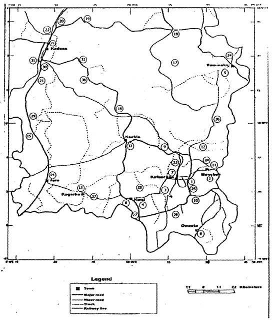 | Figure 1. Location Map Showing Sampling Points for Water Analysis |
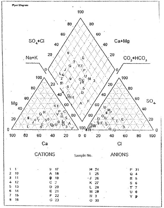 | Figure 2. Piper Tri-linear Diagram of Water Samples from the Study Area |
7. Conclusions and Recommendation
- Groundwater from Southern parts of Kaduna State constitutes a major source of water supply to the various communities in the area. The groundwater can be classified as Ca-Na-HCO3 fresh water. Results of chemical analyses of water from some of the hand-dug wells suggest that some of the wells might have been contaminated due to human activities and closeness to pit latrines/soak-away and other domestic refuse dumps. It is recommended that hand-dug wells should be lined and constructed far away from any source of possible pollution like pit latrines and soak-away.