-
Paper Information
- Next Paper
- Previous Paper
- Paper Submission
-
Journal Information
- About This Journal
- Editorial Board
- Current Issue
- Archive
- Author Guidelines
- Contact Us
Journal of Civil Engineering Research
p-ISSN: 2163-2316 e-ISSN: 2163-2340
2014; 4(3A): 214-217
doi:10.5923/c.jce.201402.36
Development of Windstorm Database System for Wind Damages in Malaysia
 Abstract
 Reference
 Full-Text PDF
 Full-text HTML
Wan Chik F. A., Che Deraman S. N. A., Noram I. Ramli, Muhammad M. K. A., Majid T. A., Zulkarnain N. Z.
Disaster Research Nexus, School of Civil Engineering, Universiti Sains Malaysia, Penang, Malaysia
Correspondence to: Che Deraman S. N. A., Disaster Research Nexus, School of Civil Engineering, Universiti Sains Malaysia, Penang, Malaysia.
| Email: |  |
Copyright © 2014 Scientific & Academic Publishing. All Rights Reserved.
Damage, losses and social problem are casualties that could create by this natural disaster. All natural disasters including those related to wind have enormous socio-economic implications in terms of the sustainability of the human habitat and built environment No complete database gathered on previous wind storm occurrence in Malaysia to study the past trend of event. A systematic wind database must be created in order to manage, to display and store the wind data. The objective of this research is to produce windstorm occurrence map and to compare wind damage with terrain category as stipulated in MS 1553:2002.
Keywords: Windstorm occurrence, Database, Terrain category, Land use
Cite this paper: Wan Chik F. A., Che Deraman S. N. A., Noram I. Ramli, Muhammad M. K. A., Majid T. A., Zulkarnain N. Z., Development of Windstorm Database System for Wind Damages in Malaysia, Journal of Civil Engineering Research, Vol. 4 No. 3A, 2014, pp. 214-217. doi: 10.5923/c.jce.201402.36.
Article Outline
1. Introduction
- Almost every year some part of Malaysia will experienced of roof damages caused by the windstorm. In Malaysia, the wind database system must be improved in order to make the information becomes more efficient and flexible. The requirement of a database system that uses the latest software is needed that can give good information to user and public regarding the windstorm events that happen nowadays. A database is an integrated collection of data records, files, and other objects. A DBMS allows different user application programs to concurrently access the same database. DBMSs may use a variety of database models, such as the relational model or object model, to conveniently describe and support applications. It typically supports query languages, which are in fact high-level programming languages, dedicated database languages that considerably simplify writing database application programs [1]. Wind data is the essential study element for wind researcher in either in meteorological field or renewable energy. Indeed, a reliable wind data also one of the aspects studies before wind system been built. However, Malaysia, there is lack of reliable and accurate wind data which present on spatial [2]. Until to date, there is no conclusive statistics that relate to the scenario of this disaster that could be referred as a whole in Malaysia are readily available. When integrating data coming from multiple different sources we are faced with the possibility of inconsistency in databases. A systematic wind database must be created in order to manage, to display and store the wind data. The current data with respect to wind data in Peninsular Malaysia is being kept in the form of news and attribute files. It will be very beneficial and time saving if a proper wind data database system is introduced to local authority.
2. Methodology
2.1. Windstorm Occurrence Map
- The study area also included Peninsular Malaysia but the raw data is compared by year 2007 to 2012. For Peninsular Malaysia, the data collection is from news report. In this study, the data were summarized general features of the windstorm occurrences scenario of the date, location, regions, number of damaged/injured/dead, cost, structure damage, and references. The coordinate system WGS corroborated by Kelab Ukur Malaysia. The finding of the coordinate of damage area is done by using Google Earth and Google Map. Preparation of the map for the studied region was done by adding layer to Peninsular Malaysia map using the GIS software. The map is produced by divide the data by month and number of damage houses. To develop the windstorm occurrence map is by import the XYZIDRIS (ASCII XYZ) file. Establishing shape files (point, line and polygon) where performed by GIS software. The result obtained will be compared with MS1553:2002 [3]. The outcome map will be compare with terrain category in MS1553:2002 Section 4 Clause 4.2.1 under terrain category definitions. The windstorm occurrence map will overlay with land use map using database query in GIS in order to get terrain category due to windstorm location.
3. Result and Discussion
- This sub-section will discuss result using GIS software on wind damages mapping. This includes data collection, data extraction for Peninsular Malaysia since year 2002 to 2012 and detail data for Penang in year 2012 only. Data collected are called raw data whereby all the information are based on general features of the windstorm occurrences scenario of the date, location, region, number of damaged, injured, dead, cost, structure damage, and references.
3.1. Windstorm Occurrences
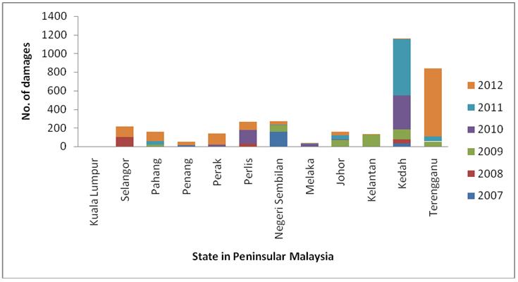
- Figure 4.1 shows the windstorm occurrence based on number of damages during the study years between years 2007 to 2012. Number of cases of windstorm occurrence in Peninsular Malaysia between the study years, the occurrences shows slightly increases from years 2007 to 2012. From this study, the total number of windstorm occurrences in Peninsular Malaysia between the study periods is 74 cases. In six years data period, it shows that the highest number of occurrence is in year 2012 which is 21 occurrences, followed by year 2011 (16 cases), year 2009 (12 cases), year 2008 (10 cases), year 2010 (9 cases) and the lowest number of occurrence is in year 2007 by 6 occurrences. Kedah state represents a maximum number of occurrences, 19 cases in six years data. Meanwhile the minimum number of occurrences is 3 cases where is Melaka and Penang state. The graph denotes that there is no data recorded in Kuala Lumpur State due to some circumstances.
 | Figure 1. Statistic of cases occurred in each state in Peninsular Malaysia (2007-2012) |
3.2. Damages of Building
- Fig.2 shows the number of damages that occurred during the windstorm event in Peninsular Malaysia between the study years. From this study, total number of 3412 damages was recorded between the study years. The number of damage is directly proportional to number of cases where the highest number of damages is in year 2012 which is 1265 damages, followed by years 2011(747 damages), years 2010 (552 damages), years 2009 (453 damages), years 2007 (215 damages) and the lowest number of damages is in year 2008 which is 180 damages was recorded. The number of damages is increases between the six years data. Kedah state represents the highest number of damages which are 1161 damages, while 36 damages in Penang state are the lowest. Majority low rise buildings among the building structures in Malaysia face the great impact during the event. It was identified that 80% of the cases caused damaged to the roofing systems due to the thunderstorm in Peninsular Malaysia. Damage breakdown shows that 47% damage in steel sheet roofing, 30% damage on trusses system, 13% damage on roof tiles and 20% for other related damages stated by [4].
 | Figure 2. Statistics of damages in each state in Peninsular Malaysia (2007-2012) |
3.3. Type of Land Use (Peninsular Malaysia)
- It is observed that most of the damaged occurs in northern region on Peninsular Malaysia. Table 1 shows the windstorm event in study area is categorized based on terrain category.
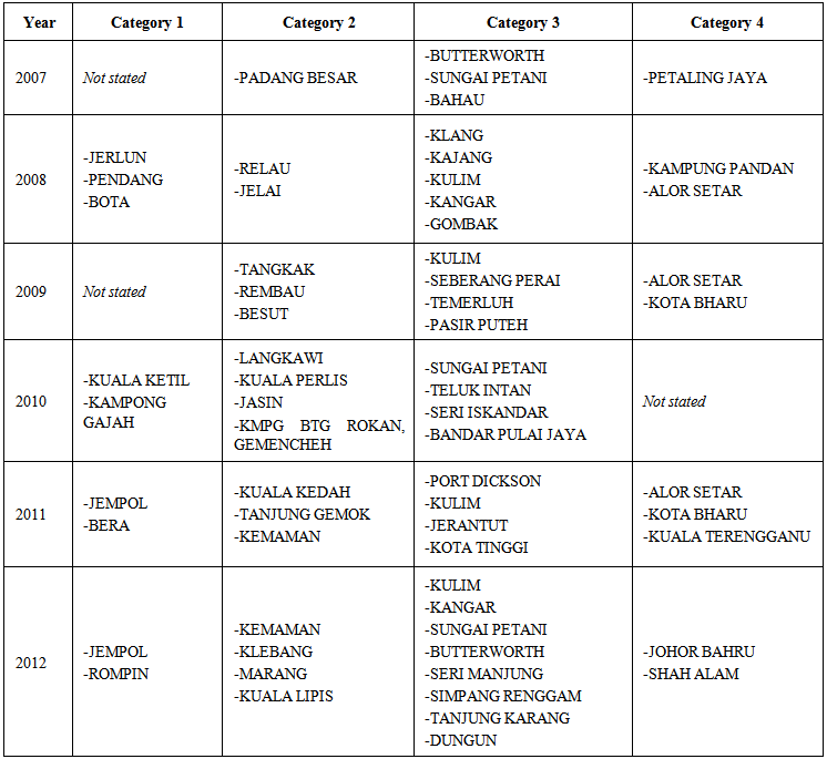 | Table 1. Classification of windstorm event in Peninsular Malaysia (2007-2012) based on terrain category |
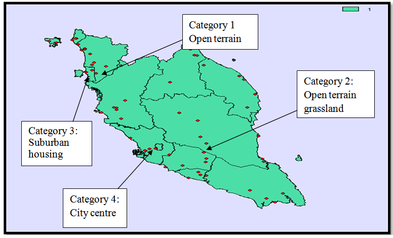 | Figure 3. Windstorm occurrences map of Peninsular Malaysia based on terrain category |
- Wind damage to low rise building mostly started with damage one of the components forming the building envelope especially roof sheeting. According to windstorm data in Peninsular Malaysia in year 2007, about 90% of damage are from roof and truss, 10% more damages are contribute from canopies, cars, dome, roof wall, porch and road facilities. From the previous study carried out, it is found that most of the failure occurred in structural system such as roof and truss. Uplifting of roof system during wind storm also caused damage to the buildings. Generally failure occurred at two points either at roof to wall connection or at roof sheeting frame [4]. Factors of windstorm occurrences such as age of houses, type of building, topography, elevation height, roof connection, vegetation, construction standards and local human behavior shall be considered. Various phenomena occur to buildings and their surroundings during strong winds, sometimes leading to failure.
4. Conclusions
- From the result obtained, Kedah state experience terrain category 1 (open terrain area) Category 2: open terrain grassland, the location in the study area is Jelai, Negeri Sembilan. Suburban area is mostly has high population because nowadays development of housing is rapidly growth. Town area mostly included in category 3: (suburban housing). Seberang perai, Penang is one of example of suburban area. Category 4 is for largely city centre area because closely space obstruction especially the location of building. From this study, Kuala Lumpur and Selangor State experienced terrain category 4.
ACKNOWLEDGEMENTS
- The author would like to express gratitude and thankful to Universiti Sains Malaysia for providing financial support from Delivering Excellence Grant for the research and Ministry of Education giving sponsorship under MyBrain15 throughout the studies.