-
Paper Information
- Next Paper
- Previous Paper
- Paper Submission
-
Journal Information
- About This Journal
- Editorial Board
- Current Issue
- Archive
- Author Guidelines
- Contact Us
Journal of Civil Engineering Research
p-ISSN: 2163-2316 e-ISSN: 2163-2340
2014; 4(3A): 145-148
doi:10.5923/c.jce.201402.25
Case Study: Wind Speed Estimation of High-Rise Building Using Surface Interpolation Methods
 Abstract
 Reference
 Full-Text PDF
 Full-text HTML
Deraman S. N. C., Wan Chik F. A., Muhammad M. K. A., Noram I. Ramli, Majid T. A., M. S. S. Ahamad
Disaster Research Nexus, School of Civil Engineering, Universiti Sains Malaysia, Engineering Campus, Penang, Malaysia
Correspondence to: Muhammad M. K. A., Disaster Research Nexus, School of Civil Engineering, Universiti Sains Malaysia, Engineering Campus, Penang, Malaysia.
| Email: |  |
Copyright © 2014 Scientific & Academic Publishing. All Rights Reserved.
This paper is based on the event in Penang that caused fatality, injuries and damages. This study focuses on high-rise building near to the incident area using the wind speed during that event. The aim of this study is to compare the best interpolation methods from the results of estimated wind speed at that respective building. The interpolation process used IDW and TIN method using GIS IDRISI Selva software. IDW method covers for all the area but TIN method do not cover beyond the triangulation point. The value of wind speed is 17.46 m/s for both IDW and TIN method but the most preferable method is IDW. The value of wind speed can be higher or lower than the estimation value if the factors that can change the value of wind speed had been considered in the mapping.
Keywords: Surface Interpolation, GIS, Wind Speed
Cite this paper: Deraman S. N. C., Wan Chik F. A., Muhammad M. K. A., Noram I. Ramli, Majid T. A., M. S. S. Ahamad, Case Study: Wind Speed Estimation of High-Rise Building Using Surface Interpolation Methods, Journal of Civil Engineering Research, Vol. 4 No. 3A, 2014, pp. 145-148. doi: 10.5923/c.jce.201402.25.
Article Outline
1. Introduction
- Windstorm is one of natural disaster happen in our country besides epidemics, floods, earthquakes, mass movement dry and mass movement wet. According to CRED [1], 21.19% of natural disaster in Malaysia related to storm. This number is not a small number but it is something to be aware and worry not only by the government but also individual itself. The common damages caused by windstorm are uprooted trees and blown off roofs. Penang state can be classified as a sub-urban area with a lot of high-rise buildings. There were too many incident related to windstorm and high-rise building. One of the incidence happened in Penang in 2013 that caused damages, injuries and fatal. This study focuses on the high-rise building near to the location of incident using the data during the incident provided by MET. Ramli et al. [2] reported that average of wind speed will increase as the height increase and force acting on structures depends on terrain category [3]. Liu [4] stated that, building or structures deflect winds, causing a change in wind speed and direction around the buildings or structures. Frictional effects show an important role for wind near the ground surface. Thus, the mean wind speed may change in direction slightly with height, as well as magnitude [5]. As stated in MET [6] report, the general features of the climate in Malaysia are uniform temperature, high humidity, copious rainfall and light wind. It also reported that the southwest monsoon season usually happened in the late half of May or early June and in September. Wind climate in Malaysia is conquered by two monsoon seasons and inter-monsoon thunderstorms Majid et al. [7].The estimation value of the wind speed at that building was determined using surface interpolation method available in GIS software tools (IDRISI Selva). IDRISI Selva is one of the GIS software that commonly used in mapping the wind speed other than ArcGIS. Spatial interpolation is the process of calculating an unknown at the specific point using a set of sample point with known values that are distributed across the area. The rules about the spatial variation and location of data collection points are important because they can significantly affect the results [9]. Apaydin et al. [8] stated that spatial interpolation has its own special which can be used to estimate meteorological variable at other location. The aim of this study is to compare the best result using two surface interpolation methods from the results of estimated wind speed at the respective building at the height of 10 m from ground surface.
2. Methods
2.1. Datasets
- The map was interpolated by using the datasets that provided by Malaysian Meteorological Department (MET) on the same date and time as the incident happened. The minimum numbers of point to be interpolated are four points which are Alor Setar, Langkawi, Butterworth and Bayan Lepas. The selected points based on the closer distance from the location of incident. There are two methods that have been used in this study which are Inverse Distance Weighted (IDW) and Triangulated Irregular Network (TIN). Both methods are used for surface interpolation purposes. Spatial interpolation is often an important strategy for creating a continuous surface when taking irregular point data [10]. Apaydin et al. [8] stated that the interpolation techniques were group into two main categories which are deterministic and geostatistical and IDW are categorized as deterministic because this technique create surface from measured points, based on either extent of similarity.
2.2. Inverse Distance Weighted (IDW)
- IDW interpolation is commonly used in GIS to create raster overlays from point data. Once the data are on a regular grid, contour lines can be threaded through the interpolated values and the map can be drawn as either a vector contour map or as a raster-shaded map [11]. Luo [12] and Chinta [13] has quoted the paper from Theissen [14] and stated that IDW interpolation combines the idea of proximity espoused. The IDW function is used when the set of points is dense enough to capture the extent of local surface variation needed for analysis; therefore, it was used in this study [15]. The principle of IDW methods is to assign more weight to nearby points than to distant points. The usual expression is,
 | (1) |
 the value to be predicted for location sₒ
 number of measured sample points surrounding the prediction location that will be used in the prediction
 the weights assigned to each measured point to be used
 the observed value at location si
2.3. Triangulated Irregular Network (TIN)
- TIN is another tool in GIS and it is a vector data structure. It creates a surface formed by triangles of nearest points. The sample data points become the vertices of a set of triangular facets that completely cover the study area. In IDRISI, the TIN is generated and then used to create a continuous raster surface model. TIN creates a constrained or non-constrained TIN from isoline or point data. In TIN method, there are two principal phases to be generated which are the selection of the point data and connection into triangular facets [16]. In this study, the IDRISI TIN module is created from the input of isoline data from fours stations in Northern region of Peninsular Malaysia. In doing so, the TIN can be constrained so no triangular facet edge crosses an isoline. This forces the triangulation to preserve the character of the surface as defined by the isolines [17].
3. Result and Discussion
- The interpolated results of wind speed using GIS IDRISI Selva software is calculated from four sets of reading during the event and at the same time. The data attribute information contains wind speed and wind direction. The wind speed data is in the unit of meter per second while the wind direction data is in unit of degree. Table 1 shows the maximum wind speed during that event for each station.
|
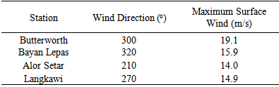
 | Figure 1. Wind Speed Map using IDW Method |
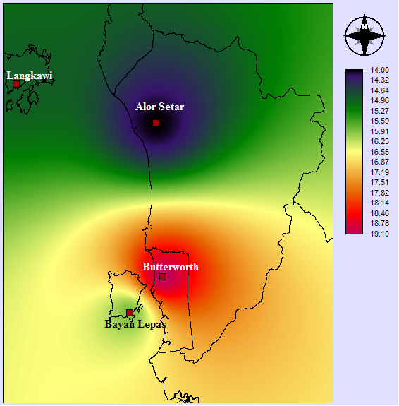
 | Figure 2. Wind Speed Map using TIN method |
4. Conclusions
- The result from IDW and TIN method give the same value of wind speed which is 17.46 m/s at the height of 10 m from ground surface. This value is not the worst that can cause the structure collapsed. It may caused by the failure of the structure itself. The use of surface interpolation is to predict the value at specific location and the most preferable method to be applied is IDW because it can be used for interpolation and extrapolation. Morever, to get the accurate value of wind speed at that building, the factors that will affected the wind speed must be considered before doing interpolation process.
ACKNOWLEDGEMENTS
- The authors would like to thank to Ministry of Education Malaysia under MyBrain15 for providing financial support during this study, Research Creativity Management Office (RCMO) for the APEX Delivering Excellence (DE) Grant 2012, Universiti Sains Malaysia and Institute Postgraduate Studies (IPS), Universiti Sains Malaysia for the IPS Graduate Fund.