-
Paper Information
- Next Paper
- Previous Paper
- Paper Submission
-
Journal Information
- About This Journal
- Editorial Board
- Current Issue
- Archive
- Author Guidelines
- Contact Us
Journal of Civil Engineering Research
p-ISSN: 2163-2316 e-ISSN: 2163-2340
2014; 4(3A): 110-115
doi:10.5923/c.jce.201402.18
Consideration about Subsurface Structure of Uemachi Fault Using Geotechnical Borehole Database in Osaka, Japan
 Abstract
 Reference
 Full-Text PDF
 Full-text HTML
Naoko Kitada1, Naoto Inoue1, Keiji Takemura2, Muneki Mitamura3
1Geo-Research Institute
2Department of Geosciences, Graduate school of Science, Kyoto University
3Department of Geosciences, Graduate school of Science, Osaka City University
Correspondence to: Naoko Kitada, Geo-Research Institute.
| Email: |  |
Copyright © 2014 Scientific & Academic Publishing. All Rights Reserved.
In Osaka, Uemachi Fault is one of the famous active faults. It across the center of Osaka and lies in N–S direction mainly and is more than 40 km in length. Pliocene to Quaternary sediment “Osaka Group” and terrace sediment are found to be deposited in the Osaka Plain. These sediment are very thick layers over 1000m therefore, fault structure are appeared as flexure zone (only vending the strata) and hidden the fault displacement around the surface. In this study, we try to show the flexure zone around central Osaka area using borehole database and decided the site of borehole drilling site and carried out the survey in order to decide the displacement rate of Uemachi fault. Sakuragawa flexure and Suminoe flexure are considered the secondary fault of Uemachi fault system. These are NE-SW trend and only several km lengths. Database show the Sakuragawa flexure wind in the plain. We carried out the drilling the borehole and sampling the core samples in the Sakuragawa flexure zone. The result of compare with the neighbor area, the average displacement speed indicates more active the Sakuragawa flexure rather than Uemachi fault zone.
Keywords: Osaka Plain, Active fault, Borehole database, Marine clay, Surface structure, Fault activity
Cite this paper: Naoko Kitada, Naoto Inoue, Keiji Takemura, Muneki Mitamura, Consideration about Subsurface Structure of Uemachi Fault Using Geotechnical Borehole Database in Osaka, Japan, Journal of Civil Engineering Research, Vol. 4 No. 3A, 2014, pp. 110-115. doi: 10.5923/c.jce.201402.18.
Article Outline
1. Introduction
- The Uemachi Fault in Osaka is an important active fault that controls tectonics and sedimentation in the Osaka Basin. It across the center of Osaka and lies in N–S direction mainly and is more than 40 km in length. The sediments that cover this basin are over 1000 m thick and, start to subsidence of the basin and aggradation from 3.5 Ma (Kitada et al., 2011 [1]). Cyclic climate change has occurred since 1.3 Ma, with at least 15 layers of marine clay having been deposited in central Osaka during warm intervals. The stratigraphy of this sedimentary sequence, known as the Osaka Group, has been summarized for upland areas on the basis of correlation of marine clay beds and volcanic ash layers.
2. Characteristics of Uemachi Fault and Borehole Database
- In Osaka, Uemachi Fault is important active fault control the tectonic movement of sedimentation of Osaka basin. Pliocene to Quaternary sediment “Osaka Group” and terrace sediment are found to be deposited in the Osaka Plain and Holocene marine clay layers (Ma13) are covered these plains in order to sea level change. Fifteen layers of marine clay beds are deposited due to the cyclic sea level changes during glacial retreats. These sediment are very thick layers over 1000m therefore, fault structure are appeared as flexure zone (only vending the strata) and hidden the fault displacement around the surface (Fig.1). The up side on the fault (east side) is modified by erosion and urban development however, many seismic reflection surveys information the fault trace line on a piecemeal basis. One of the subway construction project across the fault, are carried out the many borehole drilling survey around the fault. It is the good case to understand the subsurface structure around fault. The active fault survey is almost done by the seismic reflection survey. However the surface structure is very complicated and difficult to estimate the folding structure. The result of this study along the subway, these marine clay layers are correlated using tephra and microfossil analysis. Fault displacement is resolved by the 600m flexture zone. These flexture zone need attention of amplified the seismic wave not only the fault displacement. From 2010, Project of focus investigations for Uemachi fault start and in this program, to make clear the distribution of this flexture zone, we use borehole database of KG-Net.
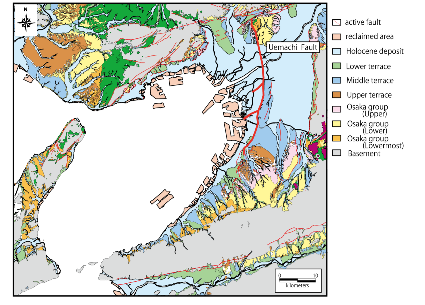 | Figure 1. Geological and tectonic map of area around Osaka Area (Active fault map in urban area, 1996 [2]) |
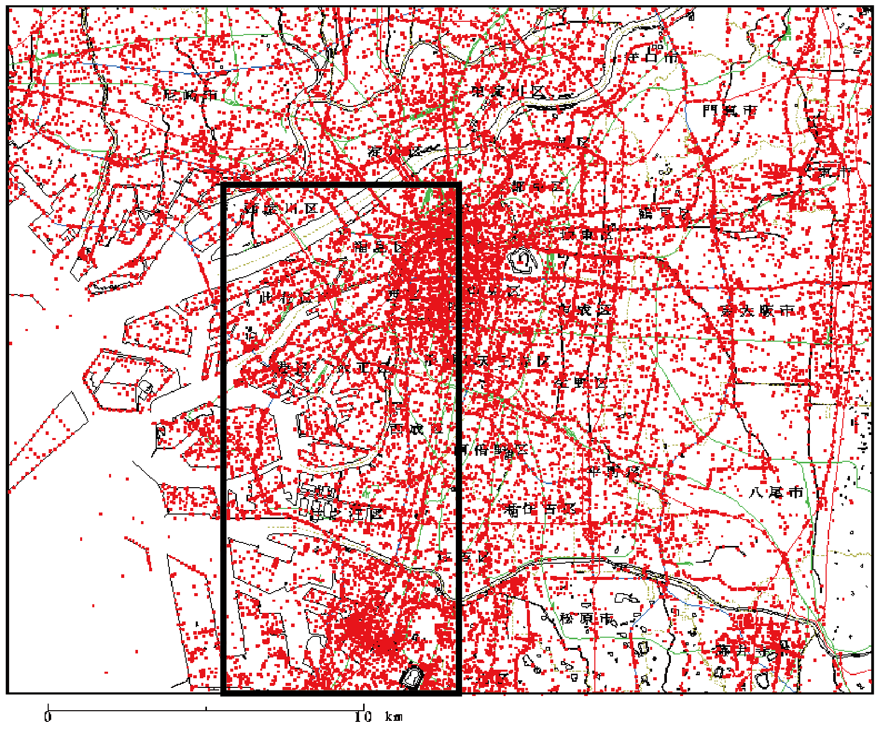 | Figure 2. Distribution of borehole database in the Osaka Basin Square shows the study area |
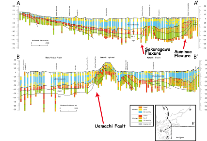 | Figure 3. Geological cross section across the Osaka plain [3] |
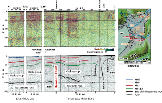 | Figure 4. Sceismic profile inth Osaka basin [4] |
3. Subsurface Structure around Uemachi Fault and Result
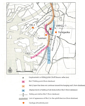
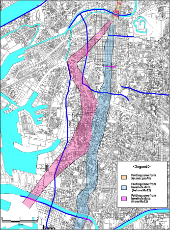
- We first examined the borehole data along the seismic reflection line and then considered the surrounding area. An example of this analysis is shown in Figure 5, which highlights the fact that the buckling is expressed particularly well in the marine clay layers. An Upper Pleistocene marine clay (Ma12) is a good indicator of the flexure zone. We constructed many cross sections in and around the fault zone and classified the deformation form into three categories around the flexure zone. First, Ma12 marine clay layers were folded and were recognized on both the up and down sides of the flexure. Second, Ma12 marine clay layers appeared to be folded, but did not continue toward the hanging wall. Third, old marine clay, which was folded or displaced, was observed. An example of the correlate between seismic profile and borehole data shows in Fig 5. The results of this study allowed us to map the distribution of folding in a zone in the west of the Osaka area. Folding can be classified into three types: (1) Ma12 folding, (2) Ma12 folding that does not continue toward the hanging wall, and (3) folding or displacement of old marine clay. Ma12 marine clay is folded near the flexure, but the hanging-wall side appears to be denuded. Type (3) is distributed around Uemachi in upland areas, but the Ma13 and Ma12 layers are not found in these areas; therefore, it is difficult to estimate later activity along the Uemachi Fault [5] (Fig 6).
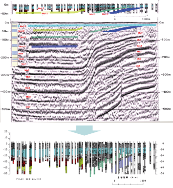 | Figure 5. An example of compare seismic profile and borehole data |
 | Figure 6. Distribution of flexure zones (Kitada et al, 2012) [5] |
 | Figure 7. Distribution of the folding zone of Uemachi Fault |
ACKNOWLEDGEMENTS
- This research is funded by the integrated research project for the Uemachi active fault system in FY2011 by MEXT.