-
Paper Information
- Next Paper
- Previous Paper
- Paper Submission
-
Journal Information
- About This Journal
- Editorial Board
- Current Issue
- Archive
- Author Guidelines
- Contact Us
Journal of Civil Engineering Research
p-ISSN: 2163-2316 e-ISSN: 2163-2340
2014; 4(3A): 103-109
doi:10.5923/c.jce.201402.17
Geological Models and Geotechnical Models – Lessons from Development of Japan-Wide Geotechnical Ground Models –
 Abstract
 Reference
 Full-Text PDF
 Full-text HTML
1Overseas Department, Kiso-Jiban Consultants Co., Ltd., Tokyo, Japan
2Geo-Informatics Engineering Group, Geo-Research Institute, Osaka, Japan
Correspondence to: Hiroaki Todo, Overseas Department, Kiso-Jiban Consultants Co., Ltd., Tokyo, Japan.
| Email: |  |
Copyright © 2014 Scientific & Academic Publishing. All Rights Reserved.
On October 15, 2010, the Japanese Geotechnical Society (JGS) released sets of geotechnical ground models for 6 cities on the internet. At the end of 2014, the public release would grow to 34 cities, and by 2017 the models of additional 40 cities would join the line-up. Hundreds to thousands of individual ground models constitute a database of ground models for a city, which is a part of the nation-wide ground model databases. Each model covers an area of 250 m by 250 m in plan and to a depth of less than 100 m from the ground surface, and was built by using data from various geotechnical information databases. The paper discusses one issue arising from rapid expansion of the model construction in number of cities. The issue is ‘relationship between geological models and geotechnical models.’ Although they are different concepts, their differences are often overlooked as they are similar.
Keywords: Digital geotechnical information database, Ground models, Urban geo-informatics, Hazard map
Cite this paper: Hiroaki Todo, Koji Yamamoto, Geological Models and Geotechnical Models – Lessons from Development of Japan-Wide Geotechnical Ground Models –, Journal of Civil Engineering Research, Vol. 4 No. 3A, 2014, pp. 103-109. doi: 10.5923/c.jce.201402.17.
Article Outline
1. Introduction
- Japan has more than 100 geotechnical information databases published since 1960 by various organizations in the form of printed media, compact disks, and the internet. Those databases are, however, diverse in terms of format, data contents, accuracy, data construction, input methods, distribution methods, up-dating methods and frequency, and subscription fees [1]. It is thus difficult for the public to compose appropriate data from various databases and comprehend the ground conditions at desired locations. In 2006 the JGS studied the way to integrate those geotechnical information databases and to publish them on the internet in consolidated, harmonized, and unified ways, so that the public can easily access and understand ground conditions anywhere in Japan. Subsequently the JGS started building their own ground models using then available geotechnical information databases and published the first version of the geotechnical ground models for 6 cities on the internet on October 15, 2010 [2]. The published ground models expanded into more cities year-by-year reaching to 34 cities at the end of 2014. During the 8 years of the development, it becomes apparent that even geotechnical specialists have difficulties in properly interpreting the data from these databases. The paper aims at improving the interpretation of the data through systematic approach by making distinction between geological models and geotechnical models.
2. Geotechnical Databases in Japan
- Before ‘the Access to Government Information Act’ was in force in 2001, there were already about 100 geotechnical information data bases (GIDB) in Japan and they were published mostly by private hands [3]. Figure 1, the locations of typical geotechnical information databases, shows that most of the databases cover small areas of one or two cities while others enclose large areas containing several prefectures.
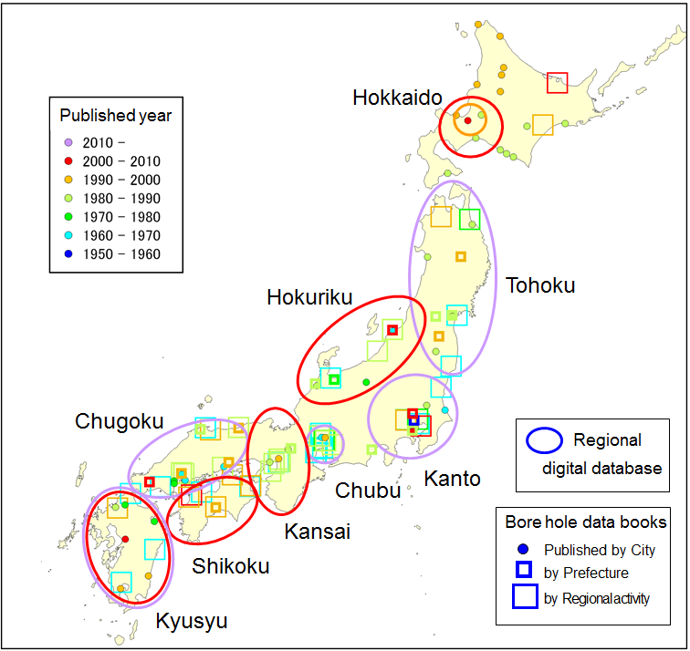 | Figure 1. Locations of Typical Geotechnical Information Databases in Japan (as of July 2014) |
3. Development of Japan-Wide Geotechnical Ground Models
- In July 2006 a 5-year, nationwide, inter-agency project, the Integrated Geophysical and Geological Information Database, started, led by the National Research Institute for Earth Science and Disaster Prevention (NIED), with the participation of the National Institute of Advanced Industrial Science and Technology, the Public Works Research Institute , Tokyo University, Tokyo Institute of Technology, and the JGS. The Special Coordination Funds for Promoting Science and Technology (SCFPST) under the Ministry of Education, Culture, Sports, Science and Technology, Japan, financed the project [5].The JGS’s mission in the project was to link the existing geotechnical databases that the Society’s local chapters took part in their construction, maintenance, and administration. For this purpose, the JGS set up a work team. After a year of discussion, the work team’s answer to ‘the linking the existing geotechnical databases’ was to make ground models throughout Japan by interpreting all the available raw data from the existing databases. The system is called Nation–Wide Electronic Geotechnical Database Systems (NEGDS), which is essentially a collection of ground models with each model representing the ground of 250m by 250m in plan to a maximum depth of 100 m. The proposed systems can digitally construct, save, modify, and display the models and the information contained there can be viewed and downloaded from the internet.The reasons for building the ground models rather than merely linking the existing databases through the internet are as follows with details given elsewhere [1].
- (1) The existing databases are very much different in their construction, systems, data structures, data contents, and data quality. It is very difficult to link such variety of databases with different contents and systems.(2) The condition that the research results funded by the SCFPST have to be open to the public makes many operators of the databases difficult to participate to the systems because all the data linked to the systems have to be eventually disclosed. The problems associated with the free disclosure are:-• Some data had been supplied with prior confidential agreement not to disclose the data due to ownership of the data, copy rights, and information on private properties.• Some data had been supplied with the conditions that data can be used for research only, and cannot be released to the public. • The databases were sold with fee.(3) The work team did not have authority over other independent database operators and could not force them to link their databases to a new system the work team was going to develop. The systems should be such that the other independently operated databases would willingly join.Building the ground models can skip the above problems related to simply linking various databases. As of July 2014, the models cover 34 cities as shown in Figure 2 and all the models will be published by the end of the year.
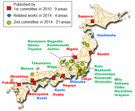 | Figure 2. Areas of Ground Models Ready for Publication as of July 2014 together with Earlier Publication |
4. Construction Method of One Ground Model
- The construction procedure of a model is as follows [1]:(1) To use a standard 250 m grid map published by Geographic Survey Institute of Japan.(2) To select the location for the model to be constructed.(3) To construct a ground model using borehole data available nearby in consideration of topography and geology. For making the ground model, the software developed by the work team is available to assist construction of a ground model from the existing digital databases.One should not simply make the model by selecting one borehole inside the area, but should build the model in consideration of surrounding ground conditions. The model thus represents average ground conditions in the area, not the ground condition at the center of the area.
5. Pitfalls during Construction of Japan-Wide Geotechnical Ground Models
- Anyone can easily construct a ground model of a particular location of 250 m by 250m area using the software developed by the work team based on the data from digital geotechnical databases at hand. Although the user manual of the software emphasizes geological, topographical and engineering interpretation for the construction of the models, the authors have observed that this statement is taken lightly by many who make the models with little training. The authors sometimes observe that geotechnical models, constructed straight away using the software with little reference to local geology, are assessed later if they conform to available published geological models such as geological cross sections. This practice is against the intent of the user manual of the software and the development team of Japan-wide geotechnical models. The geotechnical ground models should be built while referring to local geology, topography, and geotechnical engineering properties. Rapid expansion of the coverage areas to many cities is the cause for lacking well-trained volunteers. While anyone can construct the models very easily using the software with the borehole data in and around the target area, the requirement for the geological, topographical and engineering interpretation is vague without standardized procedures. Another reason for this unintended practice is that the software requires inputting soil types (clay, sand, etc.) but is incapable of handling geological classification (Holocene, Pleistocene, etc.) of each soil layer. Similarly, the software needs to differentiate between natural ground and man-made ground. For example, man-made sandy ground and natural sandy deposits are both classified as sand by the software, while their potential for liquefaction during earthquakes is very much different. The present software cannot produce the ground models where no data is available, because the ground models are constructed based on the borehole data within and around the target area of 250 x 250m. However, the models can be constructed with reasonable accuracy at such blank areas if geological models such as contour maps of the base of the Holocene deposits are available.
6. Geological Models versus Geotechnical Models
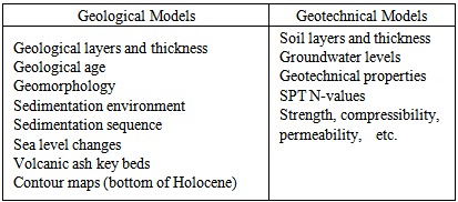
- In every-day practice, geotechnical engineers usually use the geological models and geotechnical models in the following ways. The information contained in each model is commonly as in Table 1.- Geological models; soil cross sections are first made based on topographic map, survey drawings, boreholes data, sounding results, and other information. Contour maps of the bottom of soft clay layers are often made.- Geotechnical models; ground models are constructed for the evaluation of bearing capacities and settlements based on the geological models and soil test results.
|
7. Recommendations
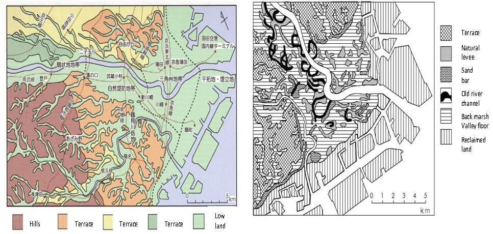
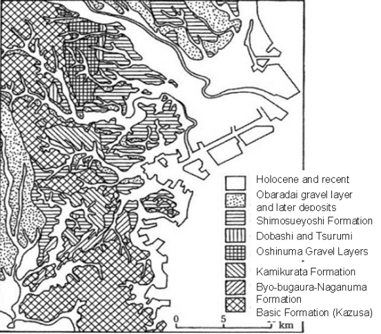
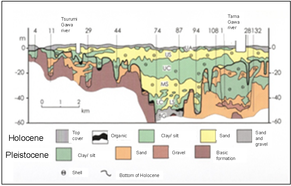
- The authors perceive the necessity of creating a standard/guideline procedure for the geological and topographical interpretation. A draft procedure is proposed below taking an example from the lower reach of the Tama Gawa River: (1) To set up a local team of specialists who have good knowledge of local ground conditions. The team should consist of geo-engineers, geologists, and specialists for topography and geomorphology because geotechnical engineers are generally weaker in interpreting topography and geology compared to geologists and geo-morphologist. A list of member has to be submitted to the central development team of Japan-wide geotechnical models.(2) To construct geological models first before making geotechnical models in order to better represent the ground conditions. This should be clearly stated in the user manual of the software. (3) To understand topographic conditions by investigating literatures • Topographic features as shown in Figure 3 • Micro-topography classification map including past meander of the rivers as shown in Figure 4• Liquefaction record map ([7] for example)• Recent topographic change such as reclamation and large scale land development(4) To understand geological history and sedimentation environment by investigating literatures • Geological map as shown in Figure 5• Published geological history and sedimentation environment• Collection of published geological cross sections such as Figure 6• Collection of published contour maps of various geological formations• Collection of other geological literature(5) To understand groundwater level by collecting published information(6) To try to comprehend the ground conditions at a particular location to be modeled• To draw geological cross sections for the area to be modeled• To identify geological formations to be present at the area • To draw contour lines for the top of the tertiary formations, the top of the Pleistocene deposits, the bottom of the Holocene deposits, the engineering base level such as SPT N-values of 30 or 50, such as shown in Figure 7(7) To cross check the identified geological formations with their geotechnical engineering properties (for example, soft clay should have high natural water contents).(8) At this stage, the software is introduced to make the ground models. The first step is to relate the soil types given in each borehole log to the geological formations. For example, each soil type is labeled as Tertiary formation, Pleistocene deposits, Holocene deposits, or the engineering base formations. This process, the most difficult part, requires discussions and judgment by specialists.(9) Now, it is ready to make models using the software.The authors also consider important for undergraduate and graduate students majoring geotechnical engineering to learn quaternary geology, sedimentology, and geomorphology, among others.
 | Figure 3. Topographic Features |
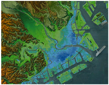
 | Figure 4. Topographic Classification (Figs. 4 to 7, Reference to [6]) |
 | Figure 5. Geological Map |
 | Figure 6. Geological Cross Section |
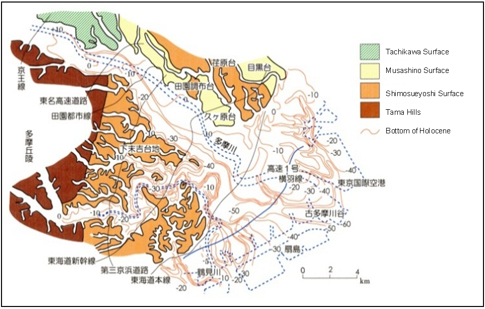 | Figure 7. Contour Lines of Bottom of Holocene |