-
Paper Information
- Next Paper
- Previous Paper
- Paper Submission
-
Journal Information
- About This Journal
- Editorial Board
- Current Issue
- Archive
- Author Guidelines
- Contact Us
Journal of Civil Engineering Research
p-ISSN: 2163-2316 e-ISSN: 2163-2340
2014; 4(3A): 83-88
doi:10.5923/c.jce.201402.14
Evaluation of Rainfall Induced Instability of Tumulus Mounds
 Abstract
 Reference
 Full-Text PDF
 Full-text HTML
Mai Sawada1, Mamoru Mimura1, Mitsugu Yoshimura2
1Department of Urban Management, Graduate School of Engineering, Kyoto University, Japan
2Soil and Rock Engineering Co. Ltd, Japan
Correspondence to: Mitsugu Yoshimura, Soil and Rock Engineering Co. Ltd, Japan.
| Email: |  |
Copyright © 2014 Scientific & Academic Publishing. All Rights Reserved.
Rainfall induced instability of a tumulus mound is one of the most serious damages to tumuli. Evaluation of water infiltration and the induced instability of tumulus mounds is an important geotechnical mission for the conservation of tumuli. This paper deals with the evaluation of rainfall infiltration into the unsaturated mound and the induced instability and damage of Kengoshizuka Tumulus. Rainfall induced failure took place in the severely embrittled surface of the mound in the rainy season of 2012. The embrittled layered structure and geotechnical properties of the mound are investigated by in-situ and laboratorytests and considered in the analytical model for the evaluation. The factor of safety in terms of slope stability is calculated using the analytically estimated degree of saturation of the mound and the experimentally obtained strength parameters of the sliding surface. The results of the evaluation quantitatively show the instability of the tumulus mound induced by rainfall.
Keywords: Historical geo-relics, Slope stability, Rainfall infiltration, Seepage flow analysis
Cite this paper: Mai Sawada, Mamoru Mimura, Mitsugu Yoshimura, Evaluation of Rainfall Induced Instability of Tumulus Mounds, Journal of Civil Engineering Research, Vol. 4 No. 3A, 2014, pp. 83-88. doi: 10.5923/c.jce.201402.14.
Article Outline
1. Introduction
- Tumuli are tombs for ancient emperors and district rulers constructed in various parts of Japan from the third to the seventh centuries. Tumulus mounds usually consist of densely compacted earth mounds and have chambers for coffins inside. The structure and construction method of a tumulus are characterized by the period and region in which the tumulus was constructed. Some tumuli have cultural heritages such as burial accessories and mural paintings in the chambers. Tumuli have been conserved as historical geo-relics which provide us important historical knowledge.Tumuli, however, have been damaged by exposure to natural environment and man-caused destruction such as weathering, earthquakes, tomb robbery, urban development, etc. This paper deals with harmful rainfall infiltration into tumulus mounds which induces slope failure. The weight of the surface layer of a tumulus mound increases, meanwhile the shear strength of the sliding surface decreases with rainfall infiltration into the mound. These instability factors induced by rainfall infiltration lead to slope failure. Water seeps deeply into the mound through the failure part and the hydrothermal environment in the chamber changes. Because of this, mural paintings in the chamber are finally damaged by fungi and insects. Evaluation of water infiltration and the induced instability of tumulus mounds is hence an important geotechnical mission for conservation of tumuli.Rainfall induced failure took place in the severely embrittled surface of the mound of Kengoshizuka Tumulus, in Asuka village, Takaichi country, Nara prefecture, in the rainy season of 2012 (Fig. 1). The tumulus was constructed in the seventh century and added to tentative UNESCO World Heritage lists in 2006 as a part of “Asuka-Fujiwara: Archaeological sites of Japan’s Ancient Capitals and Related Properties”. The present study discusses the evaluation of rainfall infiltration into the unsaturated mound and the induced instability of Kengoshizuka Tumulus. Fig. 2 shows the procedure of the evaluation.
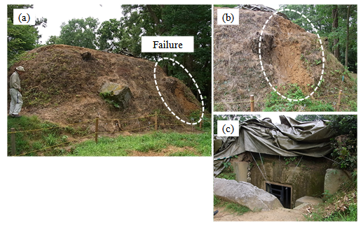 | Figure 1. (a) The north side of the tumulus mound, (b) The failure part, (c) The entrance of the chamber (August, 2012) |
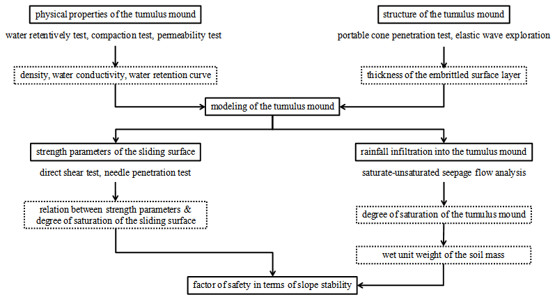 | Figure 2. Procedure of the evaluation of rainfall infiltration and the induced instability of the tumulus mound |
2. The Layered Structure of the Tumulus Mound and Geotechnical Properties of the Soil Layers
- The tumulus mound consists of densely compacted decomposed granite soil layers called Hanchiku. The surface of the mound, however, has been embrittled mainly because of repetitive propagation and die of plants. The investigation of the layered structure of the mound and the physical, hydraulic and mechanical properties of the soil layers is important in modelling of the tumulus mound.Fig. 3 shows plan and cross-section views of the tumulus mound. Elastic wave exploration and portable cone penetration test are conducted on the two lines shown in Fig. 3. The results on Line1 are shown in Fig. 4. Five points named A to E shows the measuring points of portable cone penetration test. The results of elastic wave test shows that shear wave velocity changes at a depth of 50 to 100 cm from the ground surface. The shear wave velocity in the surface layer is lower than that in the underlying layer. Around at the boundary of shear wave velocity, the penetration resistance reaches 500 kN/m2. The results on Line2 show the same tendency with those on Line1.
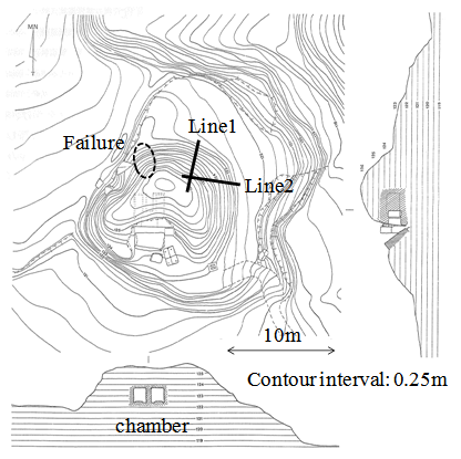 | Figure 3. Plan and cross-section views of Kengoshizuka Tumulus [1] |
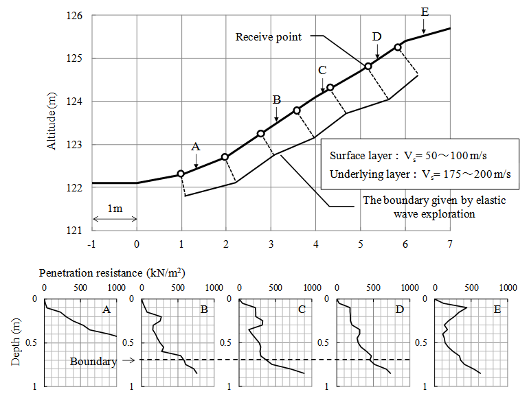 | Figure 4. The results of elastic wave exploration and portable cone penetration on Line1 |
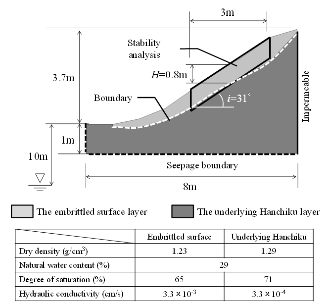 | Figure 5. The adopted model for the evaluation |
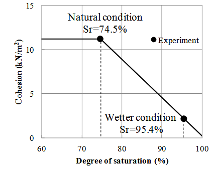 | Figure 6. Experimentally obtained relation between cohesion and degree of saturation |
3. Evaluation of Rainfall Infiltration into the Tumulus Mound and Slope Stability
- The rainfall infiltration into the tumulus mound is evaluated by saturate-unsaturated seepage flow analysis using FEM [6]. The rainfall infiltration into the tumulus mound is evaluated during seven days from 16th to 22nd June, 2012. The amount of rainfall during the period is shown in Fig. 10. The initial condition is adjusted to the measured water content of the tumulus mound by providing appropriate amount of prior rainfall and subsequent seepage period. Here, 3.33mm/hr x 30day-prior rainfall and subsequent 200day-seepage period are adopted. Distributions of degree of saturation of the mound during the seven days are shown in Fig. 7. The seepage water flows along the boundary of the two layers and the degree of saturation at the boundary increases day by day. This is because the permeability of the underlying Hanchiku layer is lower than that of the embrittled surface layer. The results of seepage flow analysis and in-situ tests shown before suggest that the boundary is vulnerable to failure.
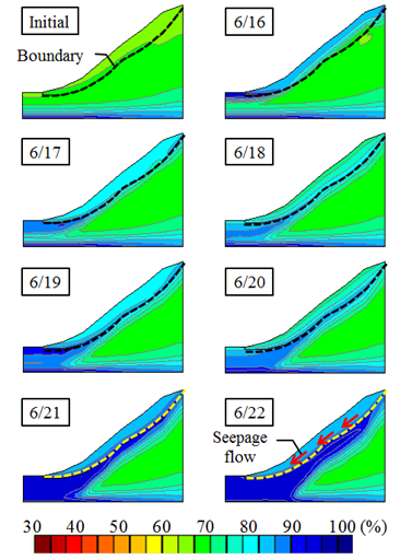 | Figure 7. The distributions of degree of saturation of the tumulus mound from 16th to 22nd June, 2012 |
 . Fig. 8 and Fig. 9 show
  and c during the seven days, respectively. The calculated safety factors are shown in Fig. 10. The safety factor continues to decrease and goes below to 1.0 on June 21st. This result explains the rainfall induced failure occurred in 2012.
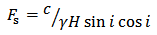 | (1) |
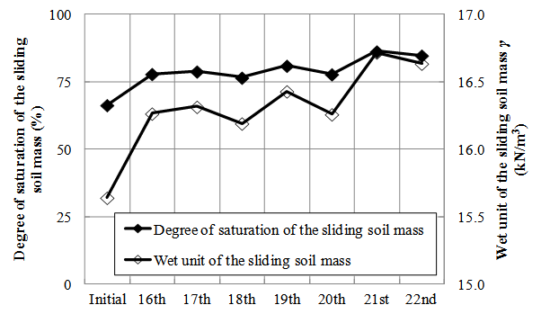 | Figure 8. Degree of saturation and wet unit of the sliding soil mass |
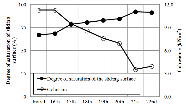 | Figure 9. Degree of saturation and cohesion of the sliding surface |
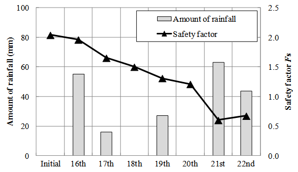 | Figure 10. The amount of rainfall and the calculated safety factor |
4. Conclusions
- The evaluation of rainfall infiltration into the unsaturated mound and the induced instability of the Kengoshizuka Tumulus are discussed. The results of in-situ tests show that the density and strength of the embrittled surface layer of the tumulus mound are lower than those of the densely compacted underlying layer. Based on this, the analysis model with the layered structure of the mound is adapted to the evaluation and the physical, hydraulic and mechanical properties of the soil layers are assessed. The rainfall infiltration into the mound is estimated by seepage flow analysis. The slope stability is evaluated using the analytically estimated degree of saturation of the mound and the experimentally obtained strength parameters of the sliding surface. The results of the evaluation quantitatively show the instability of the tumulus mound induced by rainfall.